The page was successfully edited.

|
|
Route |
|---|---|
|
|
Mountaineering, Scrambling, Canyoneering |
|
|
Summer, Fall |
|
|
One to two days |
|
|
Class 3 |
|
|
Overview
This route to Outlaw Canyon is completely different than the one up and over the Key Saddle. It climbs up to the east rim of Outlaw Canyon from inside the canyon itself using a steep big horn sheep route up a couloir.The Bighorn Couloir is rugged, but easy to find and follow and you can't get lost. There is loose rock and you might question the sanity of the four legged animals that use this route to access the rim lands.
From the rim, you can explore north and route-find into the east fork of Outlaw Canyon, or explore other destinations.
The canyon itself is fairly easy, but will require technical and natural anchoring skills. Do not underestimate the route through the canyon. It isn’t that easy and is quite challenging for most.
 Apparently, not all bighorns make it safely through these routes.
Getting There
Note: Directions are going to be very brief and this is intentional. Pay attention to the landmarks when driving and make sure to use a good map. If you can’t find the trailhead on your own, then this is not the right place for you to go climbing. I would suggest doing something like Longs Peak instead.Briefly put: To get to the trailhead drive to the park headquarters of Dinosaur N.M., which is a few miles east of the town of Dinosaur, CO (Dinosaur is located on Highway 40 just east of the Utah border). Drive north on the Harpers Corner road for north until the Echo Park Road (gravel) takes off to the right (east). Drive the Echo Park Road to a junction. Turn right at the junction and head east along the Bench Road. Follow this road to the head of Red Rocks Canyon and Park. The road is sometimes too rough for passenger cars after leaving the pavement. Moderate clearance vehicles such as Subarus should do OK, but low slung cars can sometimes have problems.
 Yampa River near the mouth of Outlaw Canyon.
Approach Map
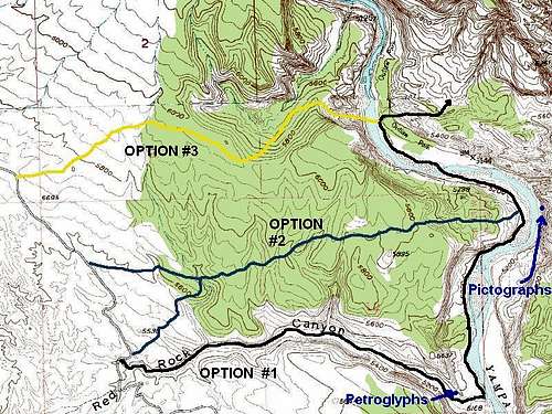 Map of Approach to Outlaw Canyon, outlining three possible routes.
Approach Route to the Mouth of Outlaw Canyon
Option #1The easiest but the longest of the three approach routes is the one down Red Rock Canyon. In my opinion, this is the best route in. From the Bench Road, follow the fence line to the canyon and drop down in. Old cattle trails can be followed for much of the way down canyon to the Yampa River, and there isn't too much bushwhacking. Near the mouth of the canyon is a signature from 1919 and some petroglyphs.
Once the Yampa River is reached, you can follow more game paths down the river to Outlaw Park. There is one section that would be tricky in high water where you must climb around a boulder. Just before the river crossing marked on the map, there is a nice sandy beach to camp on, at least at low water. There are also some very old pictographs as marked on the map above.
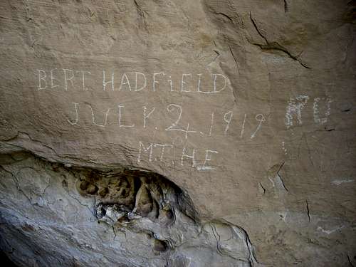 Here is a signature we found in Red Rocks Canyon on the approach to the Yampa River and Outlaw Peak.
Option #2
Another route, slightly shorter than the one above is to hike cross country from the Bench Road to the big bend in the Yampa River north of the mouth of Red Rocks Canyon. The hard part is weaving in and out of all the drainags. If you stay to the north and away from the canyon, you can avoid many of the drainages, but be sure to not go too far north and end up on the wrong point. From the end of the point above the river bend (see map), you can scramble down to the river. Follow the river down to the crossing as mentioned above.
Option #3
The most direct way to the base of the climb is to head to and climb down the gully to the river. This is the most difficult route, and a very hot one when coming back out. Briefly put, from the car park at the beginning of the route marked on the map, head towards the big drainage west of Outlaw Park. Drop into the drainage, but don't follow it down very far. Locate the gully marked on the map. You will pass a small saddle between the canyon and the access gully. See the photo. This is a very steep and rugged route and there is some loose rock and much scrambling to reach the river.
Once nice place to camp is on the sandy beach south of what is marked BM 5144 on the topo map. This is just before you must cross the Yampa to continue down river.
 Important! Route to access gully to the Yampa River.
Option #4
Just northwest of the divide between Sand Canyon and Red Rocks Canyon, a 4wd road heads to the rim of the Yampa River Canyon at the location below:
HERE
From that location, you can head south along the rim and contour around the canyon and into the gully mentioned in Option #3. This is a very rugged route, especially on the return, but it has some great views.
Route Description-Big Horn Couloir Route
Cross the river and into Outlaw Canyon using a map. Climb up and over several boulders and obstacles until a steep gully is seen to the right.This gully is your route out of Outlaw Canyon. The gully is rugged, but has a bighorn sheep trail up. Try to follow the “trail” as good as possible. The gully splits in its upper end; turn right.
This right fork will take you all the way to the rim, but there is a short class 3 or class 4 pitch right at the top. Somehow the four-legged animals climb this section and they must be at least a little crazy.
From the rim, you can explore to the east and to the north and route-find into the east fork of Outlaw Canyon. We went only to a point SE of Point 6731, so the rest of the route is up to you to explore. There may be a drop or two high in the canyon, so if exploring the head of the East Fork, you had better take some extra rope and slings just in case. Once you reach the floor of the canyon, you can trace the route that we took while exploring up canyon after dropping in from the Key Saddle.
Head down canyon, but you can explore some short side canyons along the way. You should also explore the main West Fork which is deep and narrow for quite a ways and rather impressive. We explored the canyon for about a mile and I don’t know what is beyond that.
Continuing down the main fork, there are a few obstacles and the canyon becomes a good narrow canyon. The only real obstacle is a 37 foot high rappel. Below the rappel, the canyon has no major obstacles, but is rather rugged close to the Yampa River with several boulders to climb over before reaching the mouth.
Much of the exploring is left up to you when exploring this route. I have left out some of the detail and this is some wild and untouched country, ripe for exploring. You may find something that we missed.
 AJ Scrambling in Outlaw Canyon.
Time Needed for Trip
You should probably plan on taking a minimum of 1.5 days for the trip, and preferably more. You could do it in a long day, at least if you knew the route, but his is not recommended by any means, plus you have to camp away from your vehicle anyway. It will be an easy half day to the river crossing, where there is a good campsite. You could climb Outlaw Peak and camp, and descend Outlaw or Outlaw Arch Canyon that same day (or the next morning) or take the Bighorn Route as above.It would be best to plan on a 2-3 day trip, depending on what you plan to do in the area. Our first trip went like this:
Day 1: We hiked to the campsite and drop our backpacks. From there we climbed to the saddle, doing much backtracking and exploring around the little canyons before climbing to the saddle (we actually climbed to the saddle twice since we left our daypacks down on a ledge). We then descended into Outlaw Canyon, explored the two forks up a ways, and descended Outlaw Canyon back to the river.
Day 2: Day two was spent climbing back to the saddle, to the summit of Outlaw Peak, and descending Outlaw Arch Canyon. We then waded back up river to camp.
Day 3: We climbed up the east gully near the mouth of Outlaw Canyon and to Peak 6540 for some nice views of the canyons and of Outlaw Peak. We then went back to camp and hiked back to the trailhead.
Essential Gear
Climbing harness, one 60 meter rope, and several slings and rap rings, if descending the canyon. Make sure to take extra rope if entering the very head of the east fork because you are on your own for exploring that one. Rappel in Outlaw Canyon.