
-
 16185 Hits
-
 74.01% Score
-
 4 Votes
|
|
Area/Range |
|---|---|
|
|
29.27562°S / 50.13336°W |
|
|
Hiking, Mountaineering, Trad Climbing, Sport Climbing, Toprope, Bouldering, Big Wall, Mixed, Scrambling, Canyoneering |
|
|
Spring, Summer, Fall, Winter |
|
|
4760 ft / 1451 m |
|
|
Aparados da Serra and Serra Geral National Parks
Aparados da Serra National Park (PNAS) And Serra Geral National Park( PNSG) are located southern Brazil, on the eastern boundary between Rio Grande do Sul and Santa Catarina States. The name "Aparados da Serra" means the rugged transition between the high plateau region and the litoral plain region in which grasslands form. The main goal is to conserve the grasslands, forests, and cliff vegetation refuge and all of the natural elements associated with those ecosystems. Furthermore, the both national park protects the impressive scenery formed by geological and geomorphologic processes. The main attraction of the park is the famous Itaimbezinho Canyon.Imagine the Grand Canyon covered in lush vegetation, cascading waterfalls and thriving biodiversity. Nestled along the southern Atlantic coasts of Santa Catarina and Rio Grande do Sul among Brazil's most expansive canyons, five to be exact, is the 28,000 hectare National Park and conservation area. The area is truly comprised of two parks, Aparados da Serra and Serra Geral. The highlights of the parks are the Itaimbezinho Canyon and Fortaleza Canyon, which tower approximately 2,160 feet and 2,700 feet high respectively. In the late afternoon the mysterious fogs drift in, making everything a rulers distance from your face invisible.
 Canyons and Mountains...
Getting There
There are four ways to reach Aparados da Serra and Serra Geral National Park. The first is from Porto Alegre (capital of Rio Grande do Sul) through highway RS-020, passing by Taquara and São Francisco de Paula and reaching Cambará do Sul. This route totals 182 km of paved roads. From this point on, there are still 17 km of unpaved road until the main entrance gate and visitors' center. The second option is a variation of the first, via the tourist cities of Gramado and Canela town. This option adds 58 km to the trip. The third option is the most adequate for those coming from either the shore or the north, from highway BR-101. From BR-101 near Torres town, it is an additional 19 km on an unpaved road that goes up Faxinal ridge, until it reaches the front entrance of the visitors' center . The fourth option is driving up the Serra do Rio do Rastro Road, from Praia Grande – Santa Catarina State. There is no regular public transportation to the park.
Aparados da Serra Area
Aparados da Serra Area 2
 Map
MapGeography
Aparados da Serra National Park is located in the northeast region of Rio Grande do Sul State, on the border with the extreme southeast of Santa Catarina State and shelters a portion of the beautiful Serra Geral. It covers parts of the municipalities of Cambará do Sul (60%), on the plateau of Rio Grande do Sul and Praia Grande (40%), on Santa Catarina's plain. Outside of the park but within its area of influence are the municipalities of São João do Sul, in Santa Catarina, and Mampituba, Morrinhos do Sul, Três Forquilhas, Terra de Areia, São Francisco de Paula and Jaquirana, in Rio Grande do Sul.The Park shelters geomorphologic formations of the Serra Geral, which are exceptionally beautiful and attract approximately 5,000 visitors a month. The creation of the park in 1959 signified an early concern regarding the future of such formations in Brazil's south region. In 1992, Serra Geral National Park was created, with the goal of expanding protection of the region. Serra Geral National Park's 17,300 ha adjoins Aparados da Serra National Park. The two parks are managed together.
 Geography of Aparados da Serra
Climate and Vegetation
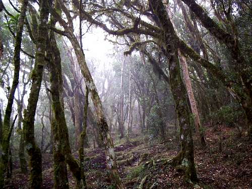
The park is located in the temperate zone, with mild temperatures and well-defined seasons. However, due to the proximity to the sea and relief formations, the climate is more subtropical. Rainfall is abundant and well distributed throughout the year, reaching 1500-1750 mm/year on the plains, and 1750-2250 mm/ year on the plateau. January is the hottest month, when the average temperature varies around 20 to 22°C. A very important feature concerning climate is the occurrence of several frosts during the year and at least one occurrence of snow in the region of the plateau.The park is found completely within the Atlantic Forest biome and, it is part of the Araucaria Moist Forests ecoregion. The park shelters stretches of low montane Atlantic rain forest, montane Atlantic rain forest, high montane Araucaria moist forest, cloud forest, grasslands without trees or shrubs, grass vegetation on thin soil with rock formations, peat swamps, and cliff vegetation.
Weather in Itaimbezinho Canyon
Camping
It is forbidden to camp inside both National Parks.Where to Stay Near Aparados and Serra Geral
There are some wild places to camp, but I do not recommend to do this if you don't know where you are. Ask to the IBAMA Police about guide services and places to camp.