The backpack
![Watch out for these]() WATCH OUT!!
WATCH OUT!!
I only had 2 days left in Phoenix and I had to climb something worth the effort.
My wife and I had spent the last 3 months working in Phoenix and our only overnight backpack just happened to help strike my interest for the climb I am about to tell you about.
March 11 & 12, 2007
We originally had planned to do the Dutchman’s Trail loop which is about a 14 mile trek through the desert. Well as some of you may well know, the desert can still get pretty hot even in early March. As a matter of fact I believe the city of Phoenix set a record for hot on the same day that we decided to head out on this adventure.
We loaded up two camelpacks for a total of 5.5 Liters between us as well as 2 Nalgene bottles, which essentially gave us a little more than 4 Liters a piece.
Bad Choice #1
We started out on the trail at around noon, almost the hottest part of the day. That was bad choice #1. I believe the temperatures reached into the high 90’s that day with no shade. Not to mention the guidebook was just a little bit off as far as the mileage goes, which ultimately made our decision for us on the following morning whether to continue on or whether to turn back the way we came.
![Beautiful sunset]() Miners Needle sunset
Miners Needle sunset
The guidebook states that it is 2.6 miles to reach the Whiskey Springs trail junction. Needless to say it was
WAY OFF! By at least a mile.
I’m not sure how many of you have hiked in the desert heat, but those that have will probably vouch that when hiking in 90-100 degree weather with no shade, that 2 miles can seem like 4 miles and so on and so forth.
It is not a very hard hike in the normal sense of elevation gain .vs. mileage but throw in the heat and it can feel a lot tougher. We made pretty good progress to the Coffee Flat/Dutchman’s Loop trail junction and then this it where it starts to climb a little more. Progress became slower at this point as we were both kind of dragging. We were definitely feeling the effects of the heat. We eventually reached the Whiskey Springs trail junction which was closer to 4 miles from the trailhead than the 2.6 miles that the guidebook stated.
We settled in and set camp for the night, just a little ways up from the junction on a mesa that provided great views in all directions. Now the guidebook stated there was water sources just a ways up from the junction and we did have a filter, but at this point we were questioning whether or not to put our faith in a guidebook that had already given us false mileage. We had 1 of 2 choices to make:
1. We could either continue on the loop and hope the book was right about the water source, making for another 10 miles and a huge leap of faith, not to mention potentially putting us in grave danger if there was not a water source.
2. After spending the night, we could go back the way we came in the early morning before the sun was really beating down on us. Having only 3 Liters of water left between the both of us. Disappointing, but ultimately the better/smarter choice in my book.
Bad Choice # 2
I bet you’re thinking that bad choice #2 is that we decided to continue on.
NOPE, bad choice #2 was much more benign. Before we settled in for the night, I placed all of our foodstuff in the daypack that I had attached to my overnight pack. I then promptly placed it within the middle of a prickly pear cactus to keep the varmints out. I didn’t realize that as well as the big spines that Prickly Pears have, they also have little tiny spines that attach to every spot imaginable on an unsuspecting backpack. Needless, to say I now own a new backpack. We just could not get all of the spines out.
We woke up in the morning to a beautiful sunrise, and I was very tempted to climb Miners Needle which was in easy view of our campsite. Unfortunately, we did not have enough water to make it safely if we ran into problems. Good choice, because we only had about 100mL of water left when we finally reached our car. The hike out was pretty nice to start with since it was early morning and mostly downhill. About 2/3 of the way to the trailhead it became tougher because the sun started to beat down on us again and we were both slightly dehydrated as we were trying to ration the remaining water until we could reach the stash we had in our car.
Needlessly to say, Miners Needle didn’t get climbed on this trip, but its temptation tugged at me for almost a month until I finally climbed it with only 2 days left on our assignment in Phoenix.
![Great camping spot]() Our camping spot
Our camping spot![Water source??]() Glad I brought my own water
Glad I brought my own water![My wife taking the heat]() My hot wife!!
My hot wife!!![Miners Needle amongst the Saguaros]() Miners Needle and Saguaros
Miners Needle and SaguarosThe climb
April 5, 2007
There must be something about me picking hot days to do these long hikes in the desert. Even though I started climbing towards Miners Needle at 8am on this day, the thermostat ended up topping out at 102 degrees. Before I even hit the trail I only had a mediocre breakfast. It consisted of a protein bar or something like that. I did however pack 5 Liters of water into my backpack as well as plenty of snacks for this 9 mile round trip hike. Progress was good and steady towards my goal, although as I got closer there was not quite a clear trail to the ridgeline that led up to Miners Needle. I first met up with the junction of the Whiskey Springs trail and the Dutchman’s Loop trail and tried heading south to meet up with the ridgeline. This did not work, although there are some great rock outcroppings that are fun to play on and provide great views of Weaver’s Needle. So I worked my way back down to the trail. From this point I gave myself 45 minutes to reach my goal or I would turn around. You see, I had left a note for my wife where I was going to go, but I wanted to make sure that I could get back home before she headed off to work. I did not want her to needlessly worry about me. Luckily, I made it up with about 15 minutes to spare.
![Migraine]() A snapshot of me during my migraine
A snapshot of me during my migraine
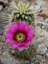
Once I reached the trail, I realized that there is a faint climbers trail leading up to the ridgeline. So I headed on up and worked my way up in between the pinnacles of the needle. Once I was on the ridgeline the climbing was nice and very relaxed. It was a lot like climbing a set of stairs, only with excellent views. There were many wildflowers blooming as well as many cacti that were flowering at this time.
I went up as far as I could physically go. The remaining climb to the summit was out of my realm of skill. To reach the top I would either need some rope and equipment coupled with rock climbing experience or a death wish. I had neither of these.
While I was near the top, I experienced an excruciating migraine, the likes of which I have never had. Elevation was ruled out because I wasn’t even at 4000 feet. There was a possibility of hypertension, but I found it odd that it would happen then and there and that it had not happened on many other climbs that I have done. My guess is that I was dehydrated and did not even know it. I had been consuming water the whole time, but in 100 degree weather, I have heard that your perspiration evaporates before you even know it’s there. This must’ve been the case. Anyway, I made quick time down, popped a couple of Ibuprofen and forced myself to drink another Liter of water, just to be safe. About 30 minutes later, my headache was gone and it was still hot outside. I gradually made it back to my car and with plenty of time to call my wife to let her know that I would make it home just fine.
End of story!
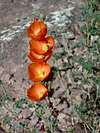
Flower Gallery


Comments
Post a Comment