Spring snowstorm in the Uintas!
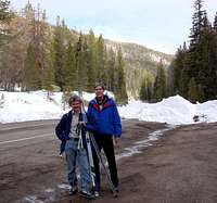
![The start of the tour]() MLH was plowed to beyond milepost 20
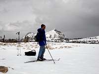
MLH was plowed to beyond milepost 20![Cardwell Ridge]() Our first goal - Mt Cardwell, 10,712
Our first goal - Mt Cardwell, 10,712
The morning after the annual Kings Peak tour, I was off to the Caribbean to spend the spring break at the beaches. Back in Utah, we found rapidly deteriorating snow - but after the Tax Day, a series of spring storms refreshed the snowpack. Hurray, it's time to put on the skis again!
We headed out of Salt Lake at 7:30 in the morning, and yet, when we reached the end of plowed Mirror Lake Highway, about a mile short of Murdock Basin junction, there was one skier's car parked there already. The snow froze well overnight. A bit of softer crust, remaining from the mid-week storms, made the glide almost perfect. The ridge of Mount Cardwell loomed ahead to the North-East.
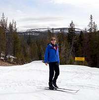
![Southwest tip of Cardie s]() Almost at the ridge of Cardie's
Almost at the ridge of Cardie's![Map session near the top of Cardies]() The highest hill of Wasatch County
The highest hill of Wasatch County
We took the Broadhead Meadows turnoff, and, a bit shy of the meadows, crossed the
Rattler Loop bridge and headed up the summer ATV track towards the base of the mountain. A section around 10,200 elevation was a bit steep and hard-crusted, but soon the angle mellowed again. No skins necessary!
The views opened like magic, first across the Lake Country to the NW, and to Broadhead Ridge and beyond to the South, then more SE and East, towrds Duchesne Gorge and Grandaddy Mountain. But the snowclouds of approaching storms were swelling ominously to the SW, and the sun rays were now fewer and far between.
![The storm is moving in fast!]() Top of Cardie's
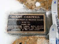
Top of Cardie's![Mount Cardwell plaque]() The summit plaque
The summit plaque
We took a few pictures at the top of Cardie's, and to my great surprise, even located the summit plaque. This part must be fairly well stripped of the snow by the prevailing winds!
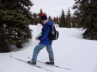
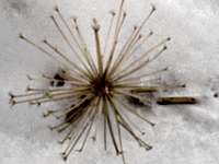
![April flowers on Cardwell]() Spring flowers?
Spring flowers?![Gentle, open West ridge of Murdock]() The ridge of Murdock ahead
The ridge of Murdock ahead
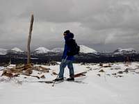
The same winds must have made the SW side of Murdock peak a mess of boulders, and for a few minutes I was certain that we will have to boot it. But on Rob's suggestion, we cut a gentle upward traverse to the North, and, sure enough, the NE slope of Murdock was skiable. The winds were raging at the summit plateau, and we could barely guess the rocky mass of Hayden Peak beyond. More snow swirled in, and in seconds, even the nearby Bald Mountain faded into the blizzard.
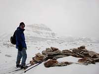
![Rob on Murdock]() Not much visibility at the highest point of our tour
Not much visibility at the highest point of our tour![The top of Murdock, 11,212]() Rock shelter in 200 ft from the Murdock BM
Rock shelter in 200 ft from the Murdock BM
After a three-week no-skiing hiatus, I couldn't find my snowpants in the morning, and by now, my blue jeans and short sleeves were looking out of place. We coasted against the gale, but by 10,800 elevation, the winds eased. A comfy snack time at last! The glide West along the open woods of the ridge was fantastic, but the visibility all but disappeared at times, and to our left, in the general direction of Broadhead Meadows, the ridgeside dropped precipitously in steps and cliffbands.
Still we were determined to follow the ridge towards Lost Lake, and to backtrack to Broadhead Meadows using a system of ATV trails South of the lake. The other obvious option - to ski the highway - would be just so boring!
![Gliding down the summit plateau of Murdock]() Gliding across the high plateau of Murdock, with Bald Mountain behind
Gliding across the high plateau of Murdock, with Bald Mountain behind![Broadhead Meadows]() Snowstorm rages over Broadhead Meadows
Snowstorm rages over Broadhead Meadows
The ridge forked
just below 10,400, and we coasted down the glades separating the two ridges, all the way down the
beautiful flat meadow in the headwaters of the Broadhead Meadow stream. Unbeknowst to us, the main jeep road South of Lost Lake CG lay barely 300 ft to the West of us now. We followed some more faded tracks for another half mile instead, but soon we were on the main jeep road at last, skirting the beautiful meadows, so springlike with their melted-out creekbanks, yet so winterlike with the raging snowstorm. Another little downhill section, and we met our morning track near Rattler Bridge.
The snow was getting sticky at these elevations, but nothing some glide wax can't fix. By 3:30 pm, we were digging out our stashed beers at the TH!
Trip Stats: approx. 17 miles, 2,800 ft elevation gain, 7 hours.
Thanks Mike for the trip suggestion, thanks Rob for all the pictures!


Comments
Post a Comment