
|
|
Route |
|---|---|
|
|
36.08672°N / 51.58749°E |
|
|
Mountaineering |
|
|
Summer |
|
|
A few days |
|
|
Hike |
|
|
Getting There
See "Getting There" on main page.Route Description
Please refer to the Detailed Map of Central Alborz for the below discussion. Having the 1:50 000 maps (See the “Maps” section of Introduction to Central Alborz) can add much more detail. You will need Sheet “6262 II Gajereh” for Varengeh Rood Village and much of the valley and Sheet “6362 III Uz” for Paloon Gardan & Palvan Peaks.All distances are per my GPS
Place…………….Elevation…………….Distance
Varengeh Rood
Village…………..2450 m……………….Zero
Junction
Of the
Stream to
Kholeno Lake…..3100 m……………….16.5 Km
Junction
Of the
Stream to
Meeshchal……..3300 m…………………2.5 Km
Saddle………….4050 m………………….4.5 Km
Paloon Gardan….4256 m………………….0.5 Km
Total……………………………………….24 Km
Get on the trail at the north end of the Varengeh Rood Village (2450 m). This trail soon crosses (via a bridge) to the northwestern side of the River (The river is too large to cross on foot). You will have to follow the river-side trail 16.5 Km to reach the junction of the branch that goes to Kholeno Lake. The trail is, for the most part, fairly well-established. We did, however, lose it at times. We were in the area in mid June. Avalanche remains covered the river frequently and provided convenient ways of crossing the river. Later in the season, when the snow has melted away, crossing the river will become a problem.
16.5 Km after Varengeh Rood Village, at an elevation of 3100 m, you will reach a major split in the river. Right goes to Kholeno Lake. Take the left branch and stay on the left (north) side of a stream where you will find a faint trail and follow the stream upstream. Be ware that in many place the trail fades away and the slopes above the stream become steep and slippery, so “following the stream” may not be as easy as it sounds.
At 3250 m you will reach a fairly large and flat area by the stream that is ideal for setting up base camp. A little after base camp at 3300 m, you will reach another major split in the stream. Right goes toward Meeshchal Peak.
 Base Camp
Stay left and follow the stream up to the very end of it just below the 4050 m saddle between Paloon Gardan to the south and Narges Peak to the north. You may want to go a little up the southern slopes of Narges Peak and then aim for the saddle. Choose a route that avoids a couple of rocky areas on the slope.
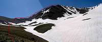 Saddle & Summit
Once on the saddle, turn south and bypass a couple of rocky spots on the saddle and the follow the steep ridgetop to the summit of Paloon Gardan. This ridgetop will be covered with “cliffs” and crumbling slippery rock but it will not require any technical skills.
 On North Ridgeline