Introduction
![The narrow entrance to Aradena Gorge]() The southern mouth of Aradena Gorge The southern mouth of Aradena Gorge |
So here we are on Crete, island of 1001 gorges. Naturally I’d prefer to climb the mountains but since everyone seems to have to explore the gorges and canyons of the island I resign myself for venturing underneath. The Samaria Gorge is out of the question – too many tourists and a logistical nightmare – if you don’t want to rely on tour operators. Where else?
Judith comes up with a suggestion – the Aradena Gorge. Located in the south of the island near Chora Skafion and connecting the mountain village of Aradena with the sea this gorge looks reachable. It is supposed to be one of the most impressive canyons on Crete and – what is more – the guidebooks suggests a loop trail. Starting at Anopolis (also a mountain village), heading down to Loutro on the coast, a coastal path along rocky cliffs, the gorge to Aradena and a mountain path back to Anopolis. 6 ½ hours, 800m elevation gain and loss – sounds reasonable.
Moreover the “loop” actually is shaped like an 8 and we certainly can cut short the small loop on top if it’ll get late. Fools that we are – shortcutting in gorges!
A Less Than Perfect Start
From Vamos on the north coast of Crete where we are living we have to cross the whole width of the island to reach Chora Skafion in the south. The road winds up to the Askifou plain which separates the Levka Ori Mountain Range in the west from the Angathes Range in the east. From Askifou it sitches back and forth parallel to the Imbros Ravine, another one of the famous Cretan gorges to end in the resort on the south coast. From Chora Skafion you climb back into the Levka Ori and here we have our first major obstacle – the road is under construction in several places and it takes forever to squeeze by the big trucks and caterpillars, to rumble through potholes with our tiny rental car and to reach the plain around Anapolis, our trailhead. By the time we reach the village the new rental car has a thick layer of dust and looks just like one of the local cars.
The Levka Ori Range above the Anapolis Plain |
Anapolis – as we find out - is a (very) long stretched village. We drive on in but then decide to return to the village entrance where we have seen a sign leading to Loutro. We park the car near a Taverna and head down the road to Loutro. It leads through the village to a chapel with a graveyard – but there it ends. We walk a couple of yards but then suddenly find ourselves in a large sheep shed with large dogs angrily barking at us. And the dirt road which heads onward from that point is clearly barred. Time to turn around.
Back at our car we decide to walk into the centre of the village – the guidebook claims that the road to Loutro starts there. It also claims that we can visit a chapel with a good view, Agia Katarini, and behind the village we can see a chapel gleaming on a mountaintop. Maybe the one we have been to half an hour ago was a different one?
After a while we curse the fact that we parked the car at the entrance to the village. The main road winds on and on and after an hour we finally reach something which could be a village centre. Another Taberna, a bus stop – this looks more like the guidebook description – and after a thorough search we find a sign pointing to Agia Katirini. Yes – this is the chapel we have seen from afar.
![Agia Katarini]() The Agia Katirini Chapel in front of the Levka Ori Range
The Agia Katirini Chapel in front of the Levka Ori Range
It’s quite annoying, however, that we still have to follow a tar road. The sun is getting higher and higher and we are in the south of Crete, close to the African Continent. It gets real hot! Finally we reach a saddle beneath the chapel and for the first time we can see Loutro and its peninsula. A wonderful view down some 600m towards the sea. Dutifully we follow the guidebook and ascend towards the chapel. An even more wonderful view awaits us – the Levka Ori lie stretched out before our eyes, right across the Anapolis plain in the north. To the south the island’s south coast stretches for miles with some smaller islands barely visible in the haze of the morning. A ferry visits Loutro beneath us, then heads onward to Agia Roumeli, the mouth of the Samaria Gorge, far away in the west.
![Loutro]() Loutro and the Loutro Peninsula
Loutro and the Loutro PeninsulaThe Coastal Leg
Now starts the interesting part of the trip. We head down from the chapel and back to the saddle where we meet an English couple. They huff and puff upwards to Agia Katirini while we squeeze through a makeshift cattle gate and head down our path to the coast. There is no wind to speak of and the bright limestone reflects large dozes of sunlight. We get dizzy in all that brightness while at the same time the heat is increasing more and more. The path is well visible though horrible to hike. Karst hopping, I would call it, jumping from one sharp-edged limestone rock to the next. Feet are starting to hurt big time. After a switchback we realize that we are headed for a dirt road, a dirt road which heads down from the Anapolis village entrance! We hadn’t been so very wrong after all!
The road turns back into a path – the going remains horrible and after we meet several people coming at us from Loutro we are happy to be descending. Climbing 600m to Agia Katirini in this developing heat is no fun and can be rather dangerous. We finally close in on the coastal village but decide not to descend all the way but rather head for the narrowest point of the peninsula. We hobble along and finally see the first Poles of the coastal branch of the European long distance trekking trail E4. We’re there!
![Bay of Finix]() Finix Bay and the rocky ledges leading to Marmara Beach
Finix Bay and the rocky ledges leading to Marmara Beach
Beyond the peninsula lies the bay of Finix, which the trekking trail seems to circumvent on the northern side. The guidebook tells us to head for the beach – but where? There is a steep drop of some 20m and we have to find a negotiable passage. Finally we do and prepare for a quick lunch on the beach. Beyond – on E4 a large hiking group confusedly heads up and down the steep face of a cliff. Apparently that’s where we have to go and we follow their progress. Some of their members are in big trouble – the climbing appears to be formidable and certainly is quite exposed. After the climbing section they end up on a broad ledge which the hike along quite easily indicating a good path.
So now it’s our turn. We head for the wall and follow the path which at first is evident. It is a very steep section until we end up on a small platform. Here most of the group members had taken a break to watch their pals climb further on up and now it is obvious why. There are many possible routes, one worse than the other, all on broken rock. We decide for the rightmost one and end up on another platform which is connected to the broad ledge by only a tiny fragment of rock. Handholds are good, though, and we manage easily.
![Looking back to Finix Bay]() Looking back from the ledge to Finix Bay. See the nudes on the beach?
Looking back from the ledge to Finix Bay. See the nudes on the beach?
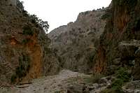
The ledge offers some good views back to Finix and Loutro but after some 800m the path heads down towards the next bay, Marmara Bay. Here we expect to see the mouth of Aradena Gorge – and finally see what we came here for. There is a small Taverna on Marmara beach but strangely enough the hiking group doesn’t stop there. They turn right and vanish into the gorge. A little while later we reach Marmara Beach and above us to the north the two faces which encompass the mouth of the gorge tower above us, like sentinels on the watchout (see picture in introduction section).
Canyoneering Crete Style
The southern part of the Aradena Gorge – the one we are just about to enter – is the most impressive one. It is only some 20 – 50m wide and the walls on both sides head up towards the sky. However, the canyon floor is covered with gravel so that hiking is quite easy. There are goats right in this narrow passage and it is quite unclear what they feed on. Maybe tourists?
Anyway – it’s a sight to see them try to flee us humans. There is no room anywhere and instinct tells them to flee upwards. But vertical walls are too difficult even for the hardiest mountain goat so they stop after a couple of meters looking down and watching us pass. Once you get used to it you’ll see goats on every improbably ledge and there’s another one trying to squeeze on to it as well. Pretty cool climbers, especially the kids…
We walk on through the gorge, craning our necks upwards. The blue sky which made the descent to Loutro so scorchingly hot now vanishes underneath a thin cloudcover, which gradually fills the whole sky,, getting darker and darker. Still there are some clear patches left. We suddenly bump into the butt end of the big hiking group as they struggle up a rockfall area, which fills up the whole gorge. They are slow so we take a break at the bottom, deciding to climb as their last member is over the shoulder. However, the rockfall area is longer than it appeared from below and we soon catch up with them, taking turns to wait out their efforts. What’s worse – another party is heading towards us, coming from Aradena. Suddenly the gorge feels crowded!
From the rockfall shoulder onwards we start to overtake the party in front of us – Germans of course, who instead of climbing, yack yack endlessly. Their advance team is already climbing a second rockfall area and we are caught in the middle. There is but one easy way up. Still we decide to pass them on a route of our own so we fall away to the left and bushwhack our way upwards. After a while we hear them beneath us and we regain the path.
Path? Wait a minute! Where have these guys been going? We hear them discussing underneath and it appears that they are lost. We – having bypassed them are as lost and while there is an opportunity to go on climbing this would take us to some ledge in the huge faces towering above us.
The sensible way to hike through a gorge is at the bottom!
How Long Is It Going To Take?
After this adventure we have the feeling that the end of the gorge must be right in front of us. There must be a way out of it to the right and a bit later we hope to shortcut the upper part of the 8-loop. Yet the gorge goes on and on and there is no sign of an exit. Instead of widening the gorge narrows again and suddenly we stand in front of another big step of boulders. A path winds up and from the top we can see quite a part of the way we came. Impressive.
Then there is a sign for the village of Livaniana, the first exit. Not for us, though – it would be a dead end with our car still in Anapolis. So on we go into the next narrow passage. The canyon floor is wide and flat here – it looks like taken from an old western – there must be a coach coming down soon and the walls above us must be infested with bandits. Nothing happens though – the bandits sure know better than to ambush two German hikers. All’s safe in Aradena Gorge!
![Aradena Gorge]() The topmost part of Aradena Gorge
The topmost part of Aradena Gorge
The gorge winds its way along while the sky gets darker and darker. There’s nothing left of the blue sky we entered the gorge with. Now everything is in shades of grey. We come to another intersection. There’s the famous Aradena ladder, the old route through the upper gorge, and the new protected route along the left side, climbing another rockfall area. We opt for the latter, not knowing that the former actually is the shorter but more demanding route. Hopefully we’ll now climb out of that neverending canyon!
Thunder!
Suddenly there is the sound of thunder echoing through the gorge. It doesn’t sound like a thunderstorm though the skies might indicate it. It rather sounds like a mighty rockfall barring our way. We look at each other – what was that? Underneath, a couple who came the old way have got lost among the boulders, which fill the canyon floor. They are not equipped for hardcore scrambling and they have no idea how to go on. We indicate their route from above, both hoping that the rock-falling thunder was not real.
Again! It’s closer now – and it definitely sounds like an avalanche of huge rocks falling down into Aradena Gorge. We pass another German team who are as irritated as we are. Thunder? Rockfall? Heading onwards we don’t hear anything for about fifteen minutes until – boom – a long rattle rips through the canyon. We must be right where it happens – but what is it?
We turn another bend and there is the roar again. But suddenly I start laughing like I haven’t laughed in quite a while. Above us – 200m above us – the Aradena Bridge spans the gorge. It is a metal construction with wooden planks as a floor. Each time a car drives over it produces a long rattle which, amplified by the gorge acoustics turns into a terrifying din! And of course the bridge is where our 8-loop joins so shortcutting would mean a vertical climb of 200m. Maybe we’re faster the regular way?
![Aradena Bridge]() Aradena Bridge, 200m above the Gorge
Aradena Bridge, 200m above the Gorge
My laughter gives way to admiration. This bridge up there definitely is a sight to see. 138m above the gorge floor is quite a lot and it looks tiny seen from our point of view. As we stand directly underneath a car drives by and we catch our breath. This din should start landslides in its own right…
![Aradena Bridge]() Aradena Bridge, 200m above the Gorge
Aradena Bridge, 200m above the Gorge
After the next bend the bridge is hidden from view again and we are finally looking for the way out of the gorge, which seems to go on and on and on and on. Suddenly on both sides old (the guidebook claims Roman) staircases and ramps lead out. We take the left one and head up slowly going back and forth on switchbacks. Out on the rim we search for a place to sit down and take a break, thinking about what we have come through and what is still to come. We’re in Aradena now – and have to get to Anapolis still.
Aradena is a ghost town – almost every house is in ruins. There are dogs and cats strayin among the ruins and lots of Arum flowers (Dracunculus Vulgaris), large deep red chalice-like cups. We had through this devastation and for the roar of the bridge as another car is crossing over. From up here the bridge is even more impressive. Its slender steel construction looks old and fragile and the wooden planks are far from reassuring. The view down into Aradena Gorge is breathtaking. I take pictures in both directions but as I hear a car coming from the other side I hurry to get on over. As a last glimpse I see that the large party also is climbing out of the canyon, however on the other side and if we don’t hurry they’ll be talking all around us again. Let’s get along!
And Back...
Luckily only the first ones have already reached the canyon rim when we pass them on the road. However, where we do our path turns right and follows the old Roman road in the general direction of Anapolis. It vanishes and hits a modern road which we hike out to join the Aradena – Anapolis road again.
![Aradena Gorge]() Looking down from Aradena Bridge into the gorge
Looking down from Aradena Bridge into the gorge
The rest of the trip is fuzzy in my memory – a long hike along the road. Suddenly we’re in Anapolis center-village. Then we follow the road to the far side of the village where our car is parked. We get in it and try to go back home. Lots of rolling obstacles on the road. First local farmers with sheep in their pickups, later tourists in their little rental cars and the large coaches of the tour companies blocking the long ascent from Chora Skafion to Askifou. A hasty drive down the wide sweeps to Vrysses and another climb towards our apartment in Vamos. Back there the weather is back to Cretan Normal again. Blue skies and intense heat.
Getting ourselves some drinks we chuckle again and again when thinking about the rip roaring thunder…


 The southern mouth of Aradena Gorge


Comments
Post a Comment