
|
|
Route |
|---|---|
|
|
41.92318°N / 111.69669°W |
|
|
Hiking, Scrambling |
|
|
Spring, Summer, Fall |
|
|
A long day |
|
|
Class 2 |
|
|
Overview
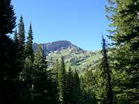
High Creek is the longest route up Cherry Peak but is also probably the most enjoyable and rewarding because of the extended views of the mountain and the beauty of the area. High Creek is in the heart of the Mt. Naomi Wilderness Area and contains some of the best sights the area has to offer. There are two branches of High Creek: the North Fork and the South Fork. The North Fork is shorter and steeper and grants access to the High Line Trail and the summit of Doubletop Mountain. The South Fork trail is more frequently traveled and follows High Creek through a broad canyon formed by Prater Mountain to the West, Bullen Hole Peak to the East, and Cherry Peak to the South. There are many natural springs, and waterfalls along this route and it also leads right past High Creek Lake. The lake is actually the destination for most people along this trail and during the summer months it can be crowded, especially on weekends. Another major attraction along the trail is the amazing wildflowers throughout the spring and early summer. High Creek Canyon from Cherry Peak
Getting There
From Logan, UT take Main St. (Highway 91) North for about 20 miles to Cove, UT. There will be a Forest Service sign directing you to the High Creek trailhead. The trailhead is about 6 miles up the road.From Preston, ID take Highway 91 South about 10 miles and follow the same signs to the trailhead.
You will need a high clearence vehicle as the road is narrow and rocky.
Route Description
Mile 1
From the trailhead parking lot take the South Fork High Creek Trail. The trail is well used and there are established bridges (Some are more like logs with the tops flattened.) the entire way for when you will cross the creek. For the first mile elevation gain is very slight and smooth. The trail follows the creek through forests of Bigtooth Maple, Cottonwood, and Fir trees. As elevation is gain the Maples will become more sparse and finally give way to forests of Pine, Fir and Aspen. You will pass several natural springs along the way. Now and then you will catch glimpses of Bullen Hole Peak.
Mile 2
 An Early View of Cherry Peak
At this point the canyon will narrow somewhat as you are passing close to the foot of Prater Mountain. The trail is now heading nearly straight South and it is along this section of the trail that you will first be able to see the massive North face of Cherry Peak poking above the trees. In the winter this section often experiences avalanches coming off the steep slopes of Prater Mountain and into the canyon. Elevation gain along this section of the trail is still slight.
Mile 3
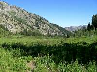 The Beaver Dams
Here the trail breaks away from the creek and starts to swtchback up the Eastern side of the canyon through dense groves of fir and aspen. This section of the trail is quite rugged and is often referred to as "the dugway". After climbing steeply out of the bottom of the canyon it continues for sometime through are relatively flat area completely forested with aspen and a few pines. This place is like walking through a history book as there are so many carvings on the aspens from various generations of different local families. Although I do not advocate this practice it is still interesting to see the dates on the different trees. (It's a little more interesting to me because I know most of the families and some of the people personally.) After a while the trail will rejoin the creek and start to dip and climb up the remains of ancient glacial morraine until it finally passes through a grove of massive pine trees and breaks out into a huge meadow called the Beaver Dams at about 7200 ft. in elevation. This is one of the most beautiful sections of this route because you finally have a clear view of Cherry Peak's North face towering over the meadow. The steep side of Prater Mountain forms the Western boundary of the small glacial valley. The eastern side is a series of broken rock and cliffs interspersed with pine and fir trees. The valley is nearly treeless except for small pockets of fir and aspen here and there. There is much evidence of avalanche activity here with debris and felled trees around the edges of the valley. This area gets its name from the many old beaver dams and ponds, now silted in making small lakes, on High Creek.
Mile 4
 Cherry Peak's Noth Face
This is where much of the elevation gain occurs and is probably the most difficult section of the trail except for maybe the final approach to the summit of Cherry Peak. It goes from about 7400 ft. to 8765 ft. in about a mile. From the Beaver Dams the trail starts to head Southeast and up into the upper reaches of the glacial valley containing High Creek Lake. The valley will significanty narrow and deepen at this point. The trail will climb to a small waterfall at the Southern end of the Beaver Dams and will then start to switchback steeply up the side of the canyon. From here the trail will climb high above the creek and work its way around the Eastern side of Cherry Peak crossing over several steep bands of cliffs until it arrives at High Creek Lake. This is the area where most of the wildflowers are visible along side the trail in the open meadows. the terrain also becomes more rocky with many large glacial erratics lying around.
High Creek Lake
High Creek Lake is a small glacial lake tucked snugly under the ragged cliffs North of Naomi Peak. There are not many trees surrounding the lake but there are several decent camping spots around. It is recommended that you not camp withing 200 ft. of the lake though. This is the destination for most of the people along the High Creek Trail. Very few continue on up the mountain.
Mile 5
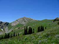 Cherry Peak's Noth Face
The summit of Cherry Peak is nearly a mile strait West and 1000 ft. above the lake. The trail coninues up the high ridge Southwest of the lake and splits; one part dropping into Smithfield Canyon. The other continuing up to the summit of Naomi Peak (which is now visible) and eventually to Tony Grove Lake. Here you will have to leave the trail and follow the ridge North to Point 9346. During the summer the brush can be quite high and difficult to walk through. Cherry Peak is clearly visible from this area and it is a straight shot from Point 9346 to the summit. There are no trees along this part of the route so the sun can get pretty intense. To the Southeast of the peak there is a large treeless bowl with a tall rocky knob to the West. There would also be some excellent camping and stargazing in this area. As you continue up the ridge it will get steeper and steeper and you will have plenty of opportunity to peer off the North side of the ridge hundres of feet down into the Beaver Dams. You will want to stay to the South side of the ridgetop so as to avoid a lot of exposure but not so far that you'll get into the steep rocks of the South side. Closer to the top it may be neccessary to use your hands for balace and support but not enough to make this a class 3.
The Top
The summit of Cherry Peak offer amazing views of Naomi Peak, Bullen Hole Peak, and almost every other peak in the Bear River Range on both sides of the Idaho/Utah border. The view down into High Creek is breathtaking as is the view of Cache Valley. It is well worth the work it takes to get there. The one drawback it the graffitti on the rocks around the summit. Appearently some people took it upon themselves to leave thier names on every rock they could find to make sure everyone else would know they had been there. There were also TONS of bees last time I was there.
Descend the by the same route.
Map
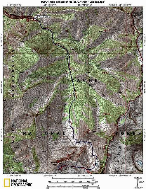 High Creek
 Essential Gear
You'll need all the essential hiking gear and sturdy boots. Bring a water filter as there is a lot of water available along the way. It all tastes great too! You can break the hike up into 2 days and bring your overnight gear too. High Creek Lake