
-
 4084 Hits
-
 74.01% Score
-
 4 Votes
|
|
Route |
|---|---|
|
|
28.17951°N / 17.19965°W |
|
|
Hiking |
|
|
Spring, Summer, Fall, Winter |
|
|
Half a day |
|
|
Hike |
|
|
Overview
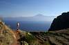
 The famous Tenerife view from the red wall of Agulo, Lomo Gordo to the right The famous Tenerife view from the red wall of Agulo, Lomo Gordo to the right |
The red wall, which rises above the coastal town of Agulo on La Gomera, is one of the most popular hiking destinations of the island. Quite improbably, an old camino leads through the north face of the wall, heading for a lookout point, the Mirador de Agulo. From there you can take in the famous view of the neighbouring island of Tenerife with Spain's highest mountain, Teide, hovering above the colourful town underneath.
The red wall also is the starting stage of an ascent to the plateau of Lomo Gordo, an ascent which passes a beautifully set reservoir and then steeply climbs the western slope of the mesa. The second part of the ascent cannot compare to the red wall but the 360° views from the plateau make up for it.
Make sure that you climb the red wall during the morning or evening hours since it gets incredibly hot during the day. As for the view, the light is best during the afternoon and early evening.
The route can be combined with the Ibo Alfaro Spur route to Lomo Gordo. Either take a bus to get back to your starting point (twice a day) or hike GR-132 along the north coast between Hermigua and Agulo.
|

Getting There
Follow the instructions on the main page of Lomo Gordo. There is ample parking space along the main road TF-711 in Agulo. You have to follow signs to La Palmita to get to the starting point of the ascent.Route Description
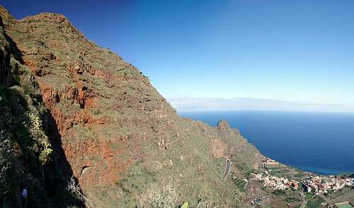 The red wall of Agulo
- Start altitude: 100m
- Summit altitude: 683m
- Prevailing exposure: N, later W
- Type: 2-3h
- Protection: None
From Agulo head for the Carretera del Norte, TF-711, to where it winds towards the road tunnel in two switchbacks. In the first (left) turn a marked hiking path heads upwards, cutting short the turns of the road. From where you join the road again, simply go uphill for a few metres, then cross the carretera to reach the starting point of the camino through the red wall. You can find it between two walls which separate garden patches.
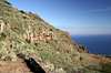
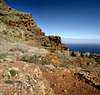
The first stage of the route is easy to find but tough to climb. The camino winds through the red wall on ledge-like shoulders and is very steep, especially at the numerous turns. The path is worn and you frequently have to use your hands. In the upper sections the ledges get quite exposed with railings in the topmost part, near the mirador.
The mirador is set a bit aside from the camino, basically east of it. For the ascent to Lomo Gordo return to the camino, which turns a corner to head southwards towards the reservoir Embals de da Palmita across let up garden terraces. At the reservoir dam a narrow mountain road joins, which you have to follow for several hundred metres to the hamlet of El Revolcadero.
In the hamlet a sign "Hermigua" leads you onto the steep path to Lomo Gordo. It heads up the west slope of the mesa, which is mostly made up from soft red tuff. Thus the path is very worn and can be very slippery in wet or foggy conditions. It heads through the northern branches of the laurisilva, La Gomera's cloud forest, before heading out on the Lomo Gordo plateau. Here it joins a dirt road, which quickly leads in the direction of the highpoint of Lomo Gordo.