Winter Ascent of South Thunder
![The start]() The start
The start![Second Hamongog]() Second Hamongog
Second Hamongog
Four of us set out at 7:15 AM from Alpine, Utah at the end of Aspen Drive, elevation 5400', Dave, Lana, Michael, and myself. Our goal was the summit of South Thunder, elevation 11,154', 5.5 miles and 5700 vertical feet away. This would be my 10th trip to the summit. With nice crystal clear skies we had perfect conditions. The previous few days had been sunny and warm resulting in a nice solid crust on our southern exposure ascent.
![Upper Bells Ridge]() Upper Bells Ridge
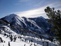
Upper Bells Ridge![Box Elder Peak]() Box Elder Peak
Box Elder Peak
Our first milestone was the "First Hamongog" a flat meadow at about 7000'. I usually take the main dirt road to get there, but my friends knew a slightly shorter way that bypasses some switchbacks. At one time you could drive all the way to the First Hamongog in the summer, but the distance you can drive has progressively gotten shorter as more and more gates have been erected across the dirt road. Now there is a gate at the very start of it and you must begin walking at the end of the pavement. We followed some tracks to just beyond the First Hamongog where they diverged from our route. It was time to put on the snowshoes.
![Heading to 9680]() Heading to 9680
Heading to 9680![Lana]() Lana
Lana
Our second milestone was the Second Hamongog, a meadow nestled at the base of the valley between Lone Peak and Upper Bells Peak. The path from the First Hamongog to the Second Hamongog is somewhat circuitous and I was glad I had gathered some GPS waypoints from a trip in August. Otherwise this section had the potential to degenerate into a nasty bushwhack through dense scrub oak. On a trip last winter the trail was completely obvious, but this year with lots more snow it was very hard to make out.
![Lana]() Lana
Lana![East of 10,035 bump]() East of 10,035 bump
East of 10,035 bumpOnce past the second Hamongog the trees quickly thin out and you can see the third milestone, the ridge to Upper Bells Peak. This section was like a sliding board as Lana's sunglasses know as they took a ride down. I dove for them but came up short, almost taking a ride myself. Michael, always the gentleman, climbed down to retrieve them. We attained the ridge at about 9400' and followed it about 200' up to an obvious flat spot. Up until we gained the ridge, the snow had had a pretty nice crust to it wherever the sun had hit, but now it was starting to get a little soggy and a few good whacks to the snowshoes were occasionally necessary.
Our fourth milestone was now visible, the 9680 bump at N40 31.050 W111 44.181. There is a ridge that starts just to the NE of this bump that you follow to about 10,400'. We traversed the half mile over to the base of the bump losing some altitude in the process. By this time we were really cooking and we stopped to shed whatever clothes we could.
![Upper Bells Peak and Lone Peak]() Upper Bells Peak and Lone Peak
Upper Bells Peak and Lone Peak![Lone Peak]() Lone Peak
Lone Peak
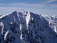
We ascended the ridge to our fifth milestone, the flat spot at 10,400', traversing to the east of bump 10,035. If you dare lean over the cliffs to the east you can see Lake Hardy below. Finally, South Thunder comes into view
![South Thunder]() South Thunder
South Thunder![Almost there]() Almost there
Almost there![Lightning Ridge]() Lightning Ridge
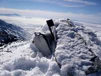
Lightning Ridge![Summit mailbox]() Summit mailbox
Summit mailbox![Michael]() Michael
Michael![Lana]() Lana
Lana![Dave]() Dave
Dave![Me]() Me
Me
Next we headed toward the saddle to the SE of South Thunder and reached our sixth milestone, the eastern base of the summit cone. At about 10,800 we hung a left and headed steeply up to the east ridge through a rocky area. I tried ditching the snowshoes here but ended up wallowing so I quickly gave up that idea. About another fifty feet up when the snowshoes were balling up badly enough to be unsafe, I decided to ditch them no matter what, but this time it was OK. Michael and Lana opted to put their crampons on, but Dave and I hadn't brought them and felt fine without. I heard some loud "exclamations" behind me and turned to see a small black object sailing down the hill. I hoped it wasn't anything crucial. Unfortunately, it turned out to be Dave's camera which managed to hit a rock at about 30 mph. There was no point in retrieving it then, so we picked it up on the return. Once we reached the ridge it was a little nippy and we had to put our coats back on. It was easy going to the summit our seventh and final milestone. We got there at 12:30, 5 hours and 15 minutes after we started.
![Lone Peak]() Lone Peak Lone Peak
|
![North Thunder]() North Thunder North Thunder
|
![View east]() View east View east
|
On the summit it was clear and sunny and there were fantastic views all around. To the southwest is Upper Bells Peak, to the west is Lone Peak, to the northeast is North Thunder blended into the Big Cottonwood ridge, to the east is American Fork Twin Peaks, Red Top, Red Baldy, and Pheifferhorn, and to the southeast is Box Elder.
![Descending]() Descending Descending
|
![Box Elder and Timpanogos]() Box Elder and Timpanogos Box Elder and Timpanogos
|
![Almost done]() Almost done Almost done
|
Our descent took 3.5 hours bringing us back to the car by 4PM just in time to hit rush hour traffic on the way home. Snow that was rock hard on the way up was now soft which made for better knee cushioning. The few other times I've been this way in the winter the dirt road leading down from the First Hamongog has been mud soup by this time of day. In the summer this stretch is brutally hot. But today we were blessed with abundant snow cover and cool temperatures and had a pleasant walk down.
![Topo of trip]() Topo of trip
Topo of trip


Comments
Post a Comment