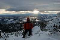
Mountain Information
Since I didn't find this mountain on Summit Post I figured I would do a trip report about it. Grizzly Mountain is 5,635 feet tall and is one of the prominent peaks visible throughout Central Oregon. The mountain is part of the Ochoco Range and is located between Prineville and Madras. There is an access road to the top that comes in from the southeast side. There are also a lot of more challenging routes up to the summit. This mountain makes for a strenous summer hike and scamble, or it can offer a good strenous winter adventure when larger peaks can't be accessed. From Grizzly Mountain you can see the Cascade Mountains to the west from Mount Hood to Mount Bachelor. You can also see the Ochoco Mountains to the east, and there is a commanding view of most of Central Oregon.
My Plan
This year being a La Nina year there has been an incredible amount of snow falling across Oregon. I have lived in Central Oregon on and off for fifteen years. The last winter of this caliber was in 1993. Having not been able to access any of the bigger mountian peaks because of the nearly constant dumpings of snow and avalanche concerns, I decided to make another summit of Grizzly Mountain. I was curious to see how much snow was on top with all of this snowfall. I have reached the summit three times in the past with light amounts of snow on it. The smaller peaks around Central Oregon were starting to look rather impressive with the bright white snow cover on them.
The Ascent
![Rime Ice Covered Tree]()
I attempted to make a summit attempt a week earlier and did not bring my snowshoes, never needing then on this mountain before. I had to turn back due to a large amount of snow at 4800 feet! So now on February 6th, 2008, I went at it again. I also wanted to try out my new bivy sack so I decided to spend the night. I drove up to the second powerline road that runs across the west side of the mountain. I could only get up the road a couple of miles before having to stop at 3400 feet because there was a foot of snow. I strap on my snowshoes and headed up the powerline road about 3/4 of a mile. I come to the major drainage that comes down the center of the mountain. Past that is a long, steep ridgeline that heads for the summit. I cross the drainage and basically start paralleling it along the ridge slowly gaining altitude. The travel is fairly easy going, with a gradual slope and around one to two feet of snow on the ground. There are also juniper trees and sage bushes. After about a half mile the terrain becomes steeper. The slope is made up of brush, junipers, and scree covered in snow. So now I'm basically aiming for the top of the ridgline which is at around 5100 feet. After another half mile the terrain become quite steep. The going is a lot slower, and I'm breaking above the juniper trees at this point. The slope is steep scree covered in snow and ice here. I'm still using my snowshoes and trekking poles. I did bring my crampons and ice axe, but didn't feel this called for it. My snowshoes offer great traction and have heel lifters which work miracles. The weather is partly cloudy, light winds, and temperatures in the twenties. I finally gain the ridgeline which has three to five feet of snow on it and also has large rock ledges. If a person wanted to be more challenged there are small variations to this route that would offer more challenge. I work my way across the top of the ridge and reach the summit. The summit has numerous transmition towers on it. The entire summit on the south side is void of trees for about the top 500 feet or so. Across the north and east slopes are pine trees and juniper trees. This area dumps out into the Ochoco Mountains. The transmition towers and what few trees are around are covered in rime ice. I take a few pictures including a cool picture of a rime iced tree that resembles a bird. I travel back down the ridge a little ways and find a nice little bivy site.
Bivy Site and Descent
I find a site under a rock cliff nestled down under a tree for my bivy. There is a large amount of snow piled here to dig in. I decide to put my bivy sack next to the cliff after leveling the snow. I build a snow block wall on my south side, since this is where the wind will come from. The cliff is on my northside. The blocks are a little hard to cut since the snow is a bit soft. I finally get this completed, and walk back out on top of the ridge above my bivy to get some sunset pictures. The ridgeline above my bivy has large snow drifts and cornices hanging off the east side. My bivy is on the south side of the ridge. Before I started this trip the weather had called for a storm to move in later that night. The weather here is hard to forecast. It all rides on whether the south wind moves in or not. This will determine if the weather will warm or stay cold. So as I'm standing there I can see all the clouds coming in and the lenticular clouds stacking up on top of the Cascades. So I know the storm is coming, I just wonder how much snow will fall. I snap some nice pictures before dark and head down to my bivy. I heat up a dehydrated meal, and some water before crawling into my bivy sack. Night falls and the wind picks up a bit. The temperature falls into the teens and I'm nice and toasty in my sack. I get a little bit of sleep before I start getting pummeled with falling rime ice. I checked the thermometer and the temperature is now 33 degrees and there is a strong south wind blowing. After a while my sack begans to condensate a bit. Finally around 2:00am and not being able to sleep I decide to attempt a night descent of the mountain. I was also quite bored and had never done a descent at dark in snow conditions, so I was eager to try. I pack everything up, put on my headlamp, and step out into the open ridge. I take out my little portbale weather station, and clock a 40 mph wind gust. The temperature is now 31 degrees and snow is falling. I'm also getting blasted by icy snow being blown up the ridge. I bundle up my face and began my traverse down the mountain. The condtions are near white out, but I can make out a couple lights off towards Redmond peaking under the clouds. I use one of them as a reference since it was near where I wanted to go. I also had my GPS to keep on track. I head down the snowy slope, which becomes softer as I head down as the temperature rises with elevation drop. The snow clumps badly under my heels on my snowshoes, making it a bit tough. After I drop about 1000 feet the blasting snow in my face ends, and the snow falling mixes with rain. By the time I get to the drainage it is just rain falling. I follow the drainage to the powerline road and eventually reach my truck.
![Sunset Behind Snowdrifts]()
![Cornices]()
![Bivy Site on Grizzly]()
Conclusion
This is a great mountain to train on and stay in shape for the bigger climbs I think. Usually it is just a steep rock scramble to the top, with moderate to heavy exertion. With the record snowfall in the area this moutian was looking more like one of the bigger alpine peaks, and was quite amazing to see these conditions not far from town. I have been up this mountain 4.5 times now. This trip was 5.7 miles round trip.


Comments
Post a Comment