
|
|
Route |
|---|---|
|
|
28.83686°N / 90.21956°E |
|
|
Mountaineering |
|
|
Fall |
|
|
Expedition |
|
|
PD (high altitude glacier route) |
|
|
Overview
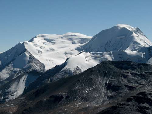 Kaluxung North (6674m, right) and South Summit (6536m, left)
The north-east route on the Kyangyong glacier can be qualified as the normal route to climb both Kaluxung North (6674m) and South (6536m) summits.
The route is quite intuitive, and starts 6km below Karo La near the small Kyangyong lake, and then follows the huge Kyangyong glacier up to the 6314m high pass located between the two summits.
Except a heavily crevassed zone just above the icefall, the route is quite safe from objective dangers and does not present important technical difficulties. The steepest slopes are located between the pass and the main summit, and safety must be assessed depending on snow/ice conditions. The post-monsoon time presents optimal hard snow conditions, but it is likely that good conditions may also prevails in winter and during the pre-monsoon.
Due to its high elevation, Kaluxung remains a serious endeavour for experienced climbers previously acclimatised.
The route is very attractive, as it goes through a massive glacier amphitheatre worthy of the high Himalayan giants. Surprisingly, Kaluxung has remained for long in the shade of its higher neighbour Noijin Kangsang, and was first successfully climbed by a Japanese expedition in September 2005 only! Furthermore, both north and south summit can be climbed on the same day!
The time required for the expedition may vary a lot depending on weather and climber's condition. At least two nights should be spent on the mountain, but it is safer to count with 3-6 days if you are not well acclimatised.
Getting There
See Kaluxung main page getting there section for the approach to the peak via Lhasa-Nagartse or Shigatse-Gyantse. The route starts 6km below Karo La at an altitude of 4800m (Lat 28°54'00"N Long 90°13'40"E).Route Description
 North-Est Route overview
Once you are on sight of the round shaped turquoise lake, do not continue along the lake shore but rather follow the the ridge and continue southwards on the grassy slopes of an old moraine. Further up, do cross transversally some steep scree slopes and continue on the moraine on the right (west) side of the icefall.
 Kyangyong Tso (4952m). Kyangyong Tso (4952m).Glacier lake at the end of the Kyangyong glacier. | 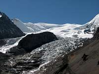 Kaluxung Icefall. Kaluxung Icefall.The climbing route follows the moraine on the right. | 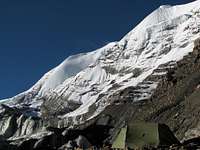 Camp on the moraine. Camp on the moraine.Near the icefall, altitude 5320m. |
 Climbing route. Climbing route.The route crosses to the left above the icefall. |
Camping possibilities exist near the lake, on the grassy slopes and at a few places on the moraine. At 5320m, there is enough space to pitch two tents on small man-made platforms. Water is available in form of ice from the nearby glacier. If the weather is warm enough, melted water may accumulate on small ponds on the glacier.
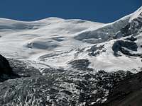
 Climbing route from camp 5320m to summit
If you decide to head for the summit from the camp at 5320m, take an early start and continue further up on the moraine. After less than one hour walk, the slope becomes steeper as you enter some snow fields bordering the glacier. You may have to put your crampons at that stage or higher up depending on snow conditions.
In order to avoid a heavily crevassed area, do cross the glacier from the west (right) to the east side (left) at a place where it is almost flat above the icefall. This is the only place where navigation can be more difficult, especially if you cross this place at night without recognising the ground on the previous day.
High camp can also be put on the flat sections of the glacier at around 5700-5800m, where there is plenty of space to pitch your tent.
 Crevassed area. Crevassed area.Cross the crevassed to the left, and then follow the gentle curve to the right again. |  Sunrise on Noijin Kangsang. Sunrise on Noijin Kangsang.Seen from an altitude of around 6'000m on Kaluxung slopes. |
Once you have crossed the tricky crevassed section, it is a straightforward climb on the gentle slopes in the middle of the glacier towards the pass between South and North Summit. This whole section is almost free of crevasses, and the massive glacier landscape is simply gorgeous.
The glacier gently turns to the right (east) towards the col at 6314m which separates the south and north summits. From the col, you can either head to the main North Summit (map 6674m, GPS 6686m) or to the secondary South Summit (map 6536m, GPS 6551m).
From the pass, the last 360m to the North Summit are steeper and can be more challenging in case of fresh snowfall or blank ice. With good snow conditions, which seem to prevail, the climb is however easy. In order to avoid the steeper slopes, it is possible to climb diagonally (northeast), and then northwest once you have reached the ridge leading to the main summit. The summit itself is a broad and almost flat ridge, from where there are stunning views on neighbouring Noijin Kangsang just across Karo La.
 Kyangyong glacier. Kyangyong glacier.Kaluxung South Summit in the background. |  Approching main summit. Approching main summit.Bhutan Himalaya in the background. |  Windy summit ridge. Windy summit ridge.On the exposed summit ridge, the west winds can be extremely strong. |
 View from the summit (6674m). View from the summit (6674m).North ridge in the foreground and Noijin Kangsang (7206m) in the background. |
Back to the pass at 6314m, it is a rewarding one hour walk to the lower South Summit. However, accumulation of snow blown by the wind can make this walk quite tiring. By clear weather, the summit offers nice view on Phuma Yumtso lake and the 7'000m peaks at the Bhutan-Tibet border. Eastwards, holy Yamdrok Yumtso lake can be seen from both summits.
For acclimatised and fast climbers, the route takes 6-7 hours from the camp at 5320m to the main summit. The whole tour camp 5320m – pass 6314m – summit 6886m – pass 6314m – summit 6551m – pass 6314m – camp 5320m takes around 11-12 hours. Camping on the glacier at 5700-5800m will shorten considerably the summit day and will avoid crossing the crevassed section at night.
 Kaluxung South seen from the main summit. Kaluxung South seen from the main summit.Background: Phuma Yumtso and Bhutan Himalaya. | 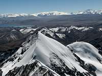 View from Kaluxung South Summit. View from Kaluxung South Summit.In the foreground, Gyalongsum (6249m). | 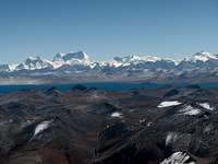 View from Kaluxung South Summit: View from Kaluxung South Summit:Bhutan Himalaya with Karjiang (7221m, unclimbed) and Kula Kangri (7538m). |
Essential Gear
Camping equipment, crampons, ice axe and very warm clothing are essentials.Rope is advisable for the crevassed section above the icefall. Snow pickets can be useful for extra protection on the steeper section between the pass and the main summit.
GPS Waypoints
GPS waypoints are around 10-20m higher than the altitudes given in the maps.P5054m: Lat. 28°53'38"N Long. 90°10'18"E Karo La
P4800m: Lat. 28°54'00"N Long. 90°13'40"E Roadside (approx. location)
P5322m: Lat. 28°52'25"N Long. 90°13'15"Camp
P6314m: Lat. 28°50'41"N Long. 90°12'37"E Pass
P6686m: Lat. 28°51'02"N Long. 90°12'25"E Kaluxung North Summit
P6551m: Lat. 28°50'13"N Long. 90°13'10"E Kaluxung South Summit