Traverse Specifics
Duration: 2 days starting at 10:45 a.m./ending 4:30 p.m.
Summits: Nye: 1:00 pm; Street: 1:30
Route: Day 1: ADK Loj – Nye- Street – West Drainage to Roaring Brook (Intersection with Lost Pond Peak) - Northville Placid Trail to Duck Hole. Day 2: Duck Hole to Henderson Pond via Preston Ponds – Henderson to ADK Loj via Indian Pass
Total Mileage/Vertical Ascent: Day 1 - 10 miles/2750’ vertical; Day 2 - 14 miles/2600’ vertical
Trail Conditions: Conditions on the maintained trails were dry in portions not near streams and very muddy near areas of water; herd path up Street/Nye has become much more eroded over the last four years.
Temperature: 80’s and humid; high 50’s at night.
Partner: WalksWithBlackflies
Diet: Day 1: 2 liters water, Lunch of MRE (Chicken Fajita), Powerbar nut (didn’t help much), Optimus Bar, ¾ cup walnuts/sunflower seeds, gorp, 1 glucose 15 gel. Day 2: Breakfast of Eggs with Bacon (hot), poptart w/o icing; 1.5 liters water, Lunch of Chicken and Dumplings MRE, Optimus Bar, Blueberry Scone, 1 gel pack. The diet felt good and I only felt hungry as I neared the end of day one from pushing the envelope of food a bit.
Clothing: Long sleeve bushwhacking shirt, rain gear, Golite trail running sneakers. Slept in bergelene with sleeping bag in bivy sack (Comfortable to hot).
Day 1: Nye/Street Bushwhack/Roaring Brook and Duck Hole
![Street Drainage SW 1]() Near the top of Street Moutain's southwest drainage to Roaring Brook.
Near the top of Street Moutain's southwest drainage to Roaring Brook.
Day one started a bit late at 10:45 a.m. for the feat we were attempting: to hike Nye and Street via trail and then bushwhack down to the Northville Placid Trail starting at the west drainage/fault-line near Street’s summit. The weather was overcast, hot and humid. I felt well, but not perfect. Much of it was mental. I’d been trying to lighten my pack and it, once again, finalized itself as heavier than I intended at about 37 lbs. for the pack and 5 lbs for the hip pack. A full sized bear canister and four days worth of food were the main culprits, however, so I pulled some small consolation from that. I felt the weight of the pack during the ascent, but to my surprise it really didn’t slow me considerably. The humid air was the real challenge, though a slight breeze seemed to come from the south as we neared the intersection at the height of the col between the peaks. We dropped our packs off at the “Y” and made a quick ascent of Nye by 1:00 p.m. On the way back, we passed two other hikers…in retrospect, the only hikers we’d see until back in the Loj parking lot.
The ascent of Street took a mere twenty minutes and found us hastily eating lunch by 1:30 in an effort to avoid the blackflies. I turned on my GPS and WWBF took out a compass as we prepared for the bushwhack to the NPT. The drainage was roughly west from the summit. This led us on a walk through the summit carpet of sphagnum moss and stunted conifers. It remained relatively open until we began to descend where it closed in quickly and brought us to a crawl…and then a cliff. Ten minutes of pushing north led us to a small slide down the ledge and into the small ravine drainage. Rich green moss covered the ground creating a maze of sod-holes, each of which attracted WWBF. Sod-holes are holes in the forest floor that are hidden from view by groundcover of one sort or another. Oddly, he followed some of my footsteps and broke through where I did not. My count at the end of the day was about four falls to his dozen or more, one of which ate his leg to his hip.
![Street Drainage SW 4]() WWBF whacking in the woods near the drainage.
WWBF whacking in the woods near the drainage.
The southwest drainage descended gradually for a bit before beginning the steeper portions. A thunderstorm rumbled it’s presence along with a short-lived shower. A gentle bubble of hidden water quickly gave way to a larger stream with more defined rubble in its center. At elevation, the rubble was still covered with moss and the trees were tightly woven. The lower we climbed, the less moss remained attached and the steeper it became. It was a blessing that the drainage also became more open as well. Within a half mile, we were funneled into a small gorge with near vertical sides at some points. I’d estimate nearly a mile of the fault is a series of dramatic rubble cascades ending with a deep mountain pool. Some required that we climb among the precipitous sides to navigate around the deep water (up to about 10-15 feet in depth). Other pools allowed us to wade the shoreline. Evidence of a substantial volume of water from spring’s melt appeared in the form of mud splattered at least four feet up the sides in some places.
![Street Drainage SW 2]() One of dozens of pools in the gorge.
One of dozens of pools in the gorge.
We first checked the time at 3:30…when we were less than halfway down to the stream intersection with Lost Pond Peak’s drainage. We were progressing very slowly (about ¾ m.p.h.) and footing was slippery. We tried to use the woods to our advantage for the duration of the bushwhack, but only small areas opened before quickly becoming choked with tightly growing conifers and/or blow-down. It was a rugged, yet incredibly beautiful area. In fact, it was one of my favorite bushwhacks and only spoiled the need to press on due to the late hour and miles ahead to the trail and Duck Hole. Its beauty was in its ruggedness: dramatic rubble cascades, gorge walls cracked and sheared by nature’s forces, moss and a minimum of blow-down in the drainage itself.
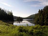
![Duckhole]() Duck Hole.
Duck Hole.Five o’clock found us at the confluence of streams…roughly our halfway point. The grade had actually decreased prior to the stream intersection and we’d begun consistently wading our way down as a result. The stream was now formally considered Roaring Brook and turned more westerly. The rocks looked the same, but became very slippery requiring careful footing for over two more miles. Again, we tried our luck in the woods and were many times forced back to the stream. The skies opened up at around 6:30 p.m. We quickly took out raingear and slogged along. The combination of fog, occasionally fogged glasses and a setting sun made the bushwhack seem relentless and oppressive. It was our longest trek off trail in these conditions. I began to recognize bends and the final straight away of the brook from aerial photos (about ½ mile). We were getting closer with each footstep when the trail finally appeared at 7:30 p.m. where the brook made a strong turn to parallel the trail for the remaining mile and one half to Duck Hole. Our original goal was Seward lean to, quite beyond, but our sites were set on Duck Hole when we arrived at 8:15 p.m…wet and ready to eat.
We changed our wet cloths in exchange for dry: I added rain pants and rain jacket as a no-see-um barrier and was able to cook noodles in relative peace as distant clouds were illuminated in magenta hues over the lake, muted only by a light fog. We’d readied our bivy sacks and set up camp in and about the lean to by 10:00 p.m. when we zipped the no-see-um netting and settled in for the night. A discussion shortly after, solidified plans for the next day. The rush of water over the dam of Duck Hole was loud, but lulled me into relaxation as I waited for sleep to settle in. Sleep, in reality, was only a distant dream as I tossed and turned until around 3:00 or 4:00 a.m. My mind was rushing in a thousand directions.
WWBF's Account:
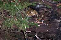
![Toad in a Hollow Log]() Toad in a Hollow Log
Toad in a Hollow LogMy life has been very hectic for the past few months, especially the past few weeks. I was looking forward to a little Adirondack-style stress relief. After working late on Friday, shopping for my eats, packing, and going to bed at 12:30, I woke up at 6:00 and hit the road around 6:30. A little shy of 4 hours later, I was at the Loj parking lot. Within 5 minutes I saw MudRat, who made a wiseass comment about starting late. Typically it would have been funny, but after being totally stressed out for the past few months, including the previous night, I was in no mood for humor. Adding to my ill mood was the fact that my pack weighed a ridiculous 41 pounds, but I had no time to try and optimize my pack contents.
The hike to Indian Pass Brook seemed to go very quickly, and I was feeling good... until things started getting steep. My legs (hips) were definitely feeling the heavy pack, but more than anything the humidity was getting to me. I was dripping sweat, and would have to stop every 15 minutes just to prevent overheating. But once past the steepest part, I felt refreshed, partly due to the westerly breeze. Even with my stops, we made good time to Nye. Street was going well until I had a mental bonk about 5 minutes from the summit. But I pushed on and we were soon eating lunch, which for me consisted of a PB&J with frequently inhaled blackflies.
![Top of the Western Drainage]() Top of the Drainage
Top of the Drainage![Western Drainage of Street Mtn]() Stream Above Roaring Brook
Stream Above Roaring BrookI can't really add much to MudRat's account of the descent of the drainage, except that my stomach gave me some problems for about 15 minutes, followed by numerous ankle-eating and shin-scraping sod holes, followed by me running out of water. In about 3 hours, I had drank 3 liters of 1/3 strength Gatorade. After starting to get some minor cramps in my left hamstring (worsened by a sod hole that bent me over backwards), I decided I had to get some more water.
At this point, we found that hiking in the stream was quicker than navigating through the woods, and the water on my feet had the added benefit of helping me stay cool. At a chokepoint, we exited into the woods, and I literally fell with both feet into a hip-deep sodhole. I was thinking it would make a good photo, until I realized that my feet still weren't touching solid ground. I had visions of devils and demons grasping at my feet, so I wisely grabbed MudRat's hand and pulled myself from the abyss. Although no devils grabbed my ankles, there were demons in this gorge... manifest as hordes of blackflies and deerflies. I must have killed 300 deerflies this day.
Things went well, although S-L-O-W-L-Y, until we reached the intersection of Roaring Brook. I don't know if water chemistry or something changed, but all of a sudden my water shoes weren't gripping the rock... at all. I fell backward twice, getting the bottom of my pack wet (where my sleeping bag was housed).
The middle section of the drainage was my favorite. The flat terrain and small cobbles reminded me of Scott's Clearing. Soon after, the terrain became steeper with the typical plunges and pools. By this time, I was bonking (in retrospect because I had only consumed about 500 calories all day), and really wanted to be on the trail. Not to mention it began raining, and the additional clouds were making the sky darken prematurely.
Once I saw a hill directly in front of us, I knew the NPT was very close, and my spirits rose. The hike on the trail was strangely quiet, with MudRat and I barely exchanging a word. We were tired, and the lean-tos at Duck Hole looked like the Ritz.
We unpacked, cooked dinner, filtered water, ate, and tried in vain to keep the blackflies and no-see-ums off us. I ended up drinking about 5 liters of water this day. Unlike Kevin, I fell asleep quickly and relatively soundly.
Day 2: Duck Hole to ADK Loj via Indian Pass
![Indian Pass 1]() Wallface from south of Indian Pass.
Wallface from south of Indian Pass.
WWBF and I awoke somewhere before 7:30. We acknowledged each other by each affirming the fact that we’d each been silently watching no-see-ums crawling about on our netting for close to one half hour. Neither wanted to be the first to crack the zipper and be first to donate blood to the ungrateful midges. After working up the courage to confront an enemy smaller than the head of a pin, we put our clothes in the sun to dry and ate while enjoying a beautiful crisp day already in full glory. Our packs were on our backs by 9:30 and we were off to the trail to Lake Henderson via Preston Ponds and MacNaughton’s herd path trail head route. This trail departed from the NPT at the northern end of Duck Hole after crossing Roaring Brook (again). It took an hour and one half to steady walk to reach MacNaughton’s herd path trailhead. The overall trail was muddy whenever water was near, but the overall terrain was gentle. I reminisced to last fall’s hike of MacNaughton with Mark Lowell as we passed a large burl in a tree. The spiders appeared to be working overtime building reinforced webs. In spite of that, we arrived at the Henderson Lake lean-to for lunch at 11:45 a.m. where a gentle breeze was blowing across the lake under the bright blue sky. An MRE of chicken and dumplings revived me.
![Indian Pass 2]() Wallface from the north of Indian Pass.
Wallface from the north of Indian Pass.
A bit of humor inserted itself via trail signs and redirected our minds from the task at hand. A sign near Lake Henderson said, “ADK Loj 9.5 miles”. Another sign at the intersection a half mile closer to the Loj then stated that the Loj was even farther away, over 10 miles. Yet another sign less than a mile along the path stated that the Loj was suddenly 6 miles away through Indian Pass. If the signs are accurate then Adirondack Wormholes truly exist and space/time can be bent!
The mileage from the Upper Works area to Indian Pass ticked off quickly. Several muddy spots slowed us slightly in the area in and around Wallface Ponds drainage. This was my first trip through the legendary pass written about so many times throughout the ages. WWBF seemed excited to show me and I was excited to see the rugged area. The path gradually ascended until the first glimpses of Wallface peeked through the trees like a giant stone sentinel. A “climbers” path veered left (west) from the main path. It led to the base of Wallface for rock climbers: souls braver with heights than I. Pieces of the great face, sloughed off in times long forgotten, littered the forest and choked the way as we ascended the Marshall side of the steep pass. Ladders in some areas helped make the climb more accessible. The climbing seemed to go ever up (though the vertical gain was only about 1250’ from Lake Henderson) until it eventually led to the height of land. Swarms of blackflies tormented Rico and I whenever we stopped walking. The humid still air did nothing to help.
![Indian Pass Boulder]() Small moss covered boulder in Indian Pass.
Small moss covered boulder in Indian Pass.
An overlook (marked with a sign) provided the best pics of Wallface near the top of the pass. Monolithic chunks of the mountain continued to bottle the pass as we reached the final height of land. Some pieces were twice the size of a two story house. Small evergreens and moss covered various parts and ice with snow still found a home in some small caverns…protected by some elevation in combination with cool boulders and shade. A breeze finally broke the stillness as we began the slow descent over the rubble and next to a small stream.
![Scott Clearing]() Scotts Clearing
Scotts Clearing
Upon the leveling of the trail at a stream intersection, we broke for a water refill and snack where I ate a blueberry scone, nutrition bar and some dried fruit. Lost Pond Peak was a pretty site against the bright blue sky as we walked on the now gentler path toward Scott’s Clearing and the intersection east to Marshall via Cold Brook Pass. Scotts Clearing boasted an overgrown path that paralleled Indian Pass Brook. We waded in the water several times to cross in the area of the old stone dam.
The trail over remaining five miles was a series of gentle ups and downs along Indian Pass Brook until it veers before the path to Mt. Joe at the end of Heart Lake. The trail, with its roughly 500’ more of climbing, was devoted to a quick paced walk back to the Loj which we reached at 4:30.
WWBF's Account:
Sunshine greeted our waking eyes, and we used it to full advantage to (almost) dry our soaking wet clothes. Neither of us was in a hurry, and two hours after waking, we hit the trail. I tried keeping my feet dry, but after 1/4 mile on the Preston Ponds trail, I realized it was futile. This trail was much muddier than when I traversed it last year. The last mile seemed to take longer than I remembered, and the lean-to at Henderson Lake was a welcome sight. I refilled my water bladder about 10 minutes prior to the lean-to.
Other than laughing at the absurdly incorrect trail mileage signs, the hike from Henderson Lake to the beginning of Indian Pass passed by without incident, except for the incessant deerflies. A wet bandana placed on my head helped keep the little demons away. Well, not away, but it did keep them from landing.
I enjoyed the steep hiking up the pass this time around, and I wondered how many of the massive blocks we passed around, through, over, and under came from the wall on the opposite side of the pass. We looked for rock climbers on the wall, but didn't see any. Actually, we didn't see anyone this day. Decending down the pass, I ran out of water (again) and refilled at the stream at the bottom of the pass.
A short hike led us to one of my favorite spots in the Adirondacks... Scott's Clearing. We took the unmarked "low water" route, and we soon found ourselves at the campground. From this point, I set a quick pace up the gradual ascent to the Loj. MudRat probably thought I was trying to "break" him, but in reality I was finally feeling good and keeping the quick pace kept my mind occupied over the otherwise dull hiking trail. I drank 4 liters of water this day.
Afterwords
WWBF's Account:
It had been a very long time since I felt so bad (mentally and physically) on a hike. I can't explain why I drank so much water. However, I've since come to the conclusion that the mental anguish is due to a bad case of High Peaks burnout. As bad as I felt, I have to admit that the bushwhack off Street was very picturesque, and would have been a great whack if not for being rushed that day. And Indian Pass is always a sight to behold.
After some reassessment of goals, I'm now looking forward to doing more exploring and less goal-oriented hiking.
I should also note that the gorge on Street is not someplace you'd want to be during a flash flood.


Comments
Post a Comment