Monte Plauris / Lopic from the SE

Monte Plauris / Lopic from the SE

Page Type Page Type: Route
Location Lat/Lon: 46.35935°N / 13.19584°E
Additional Information Route Type: Hiking
Seasons Season: Summer, Fall
Additional Information Time Required: Half a day
Additional Information Difficulty: A very steep hike-up
Sign the Climber's Log

Rating the Route (By Hiking Standards)

The grading system for hiking and scrambling routes is here.

0. General: From 1331m to 1958m, exposition SE, S and W (crossing steep grassy slopes). At first an easy hike-up, then a steep ascent over grassy slopes. On two crossings of steep W slopes quite some care needed, the same holds true for the final ascent. Gear: Good hiking shoes and poles. The Italian grade is: EE (Escursionista Esperto = Experienced Hiker).

1. Effort: cca 650m, 2h 15min (from the valley 1500m, 4h 45min).
2. Power: 1 - No difficulties.
3. Psyche: 3 - Medium.
4. Orientation: 2 - Easy.

Getting There

Monte Plauris map
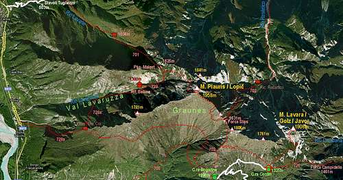
A map of the area - please open to enlarge!

We start the tour either on Casera Confin, 1331m, or on Casera Ungarina, 1296m. They are both reachable by car, but only when Agriturismo Casera Confin is opened. If you walk from the parking place down in Val Venzonassa (475m), you should count with an additional 2h 30min of walk-up. The road can be done by a mountain bike (steep), a very beautiful option is also a hike by the church of San Antonio Abate. In that case, from the cauldron of Graunês it is recommendable to take a direct pathless ascent on Forca Slips and further on top.

Route Description

Above Malga ConfinAbove Malga Confin
Meadows above Val VenzonassaWestern views
From Agriturismo on Malga Confin, 1331m, we take the path, which crosses broad meadows towards the NW. It is easy and panoramic, until it reaches a distinct ravine. Beyond it the path starts ascending in many steep switchbacks. Over the grassy slopes of a side rib the path finally reaches the ridge, which descends from Jôf di Ungarina down to Malga Ungarina. There from the left also the marked path, coming up from Malga Ungarina, joins us.
On the side ridge of Jof di UngarinaOn the side ridge of Jôf di Ungarina
Up the side ridge of Jof di UngarinaBy the ridge
Monte Plauris / Lopic from the SEThe summit and Point 1848
By the nice grassy ridge we continue northwards. Where the ridge would become steeper, the path deters left and starts crossing the western slopes of Jôf di Ungarina. They are very steep, so when grass is slippery, the path might here be also a bit tricky. Still the path uses a beautiful ledge, which is mostly broad enough. Before us, above Forca Slips, a sharp rocky tower of the unnamed peak 1848m rises, and left behind it, we can already see also the summit of Monte Plauris / Lopič. On Forca Slips, 1631m, the path first slightly descends below the southern rocks of peak 1848m. Then soon it starts ascending again. The western slopes of point 1848m are very steep again. The path requires a lot of care, especially on a descent. We go all the time steeply up, until reaching the main ridge again. From this place the point 1848m is not as attractive, as from the other side.
On the SE ridge of M. Plauris / LopicThe summit ridge
The next part of the route is a pure joy. A fairly steep, very panoramic ridge brings us just below the final rocks of Monte Plauris / Lopič. The last part is the steepest. A tiny path winds up over grassy and rocky slopes and a lot of care is needed. Just below the summit we hit the better path, coming from the left, and continue a few minutes more towards the right on top. From Malga Confin 2h 15min.

For the ascent to malga Confin, see the 'Getting There' section on the main page of Monte Plauris / Lopič.

If going directly from the valley of Venzonassa on top, you start on 514m on the road and walk-up towards the north to the charming church of San Antonio Abate. Continue in the NE direction towards Stavoli del Farc, in the Graunês cauldron. There the path turns right towards Casera Ungarina, but we continue in the same direction (no marks) up, after 200m of ascent cross the upper path and over steep grassy slopes ascend directly on Forca Slips. From there, as described on top. 4h.

Children

Children

Children refers to the set of objects that logically fall under a given object. For example, the Aconcagua mountain page is a child of the 'Aconcagua Group' and the 'Seven Summits.' The Aconcagua mountain itself has many routes, photos, and trip reports as children.

Parents 

Parents

Parents refers to a larger category under which an object falls. For example, theAconcagua mountain page has the 'Aconcagua Group' and the 'Seven Summits' asparents and is a parent itself to many routes, photos, and Trip Reports.