Introduction
All Pictures
Saturday, September 27, 2008
Objectives: Sentinel Point (12,527')
Route: Northeast ridge from Horsethief Park
Total Distance: ~9.0 miles
Elevation Gain: ~2850 ft
Participants: Jim & Karen
A couple of years ago, Karen and I took an enjoyable hike up to Pancake Rocks on the west side of Pikes Peak hoping to score some stellar views of the fall colors around Cripple Creek. We were about a week too late that year, so we hoped to have the timing right this year. Sentinel Point offered the benefits of being close to home, moderate in distance and elevation gain with a short summit scramble, and conveniently along the scenic drive to Cripple Creek.
I wish I could express what a pleasure it was to sleep in until 7am on a Saturday, after summer after summer of early wake-up calls to work on the almighty 14er checklist. Liberation from "the list" is bliss. We made our way to the Midland Terminal Railroad Tunnel TH and were on the trail by 9am.
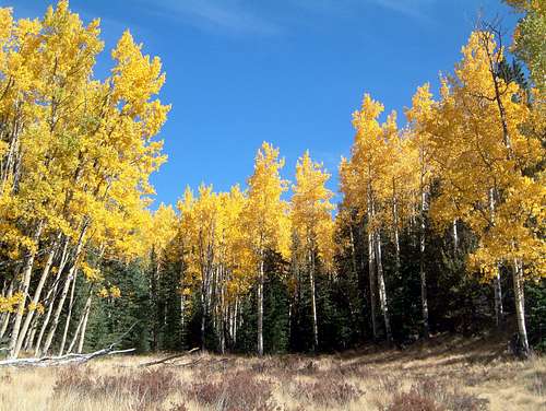
![Fall Colors]() Fall colors across from the trailhead
Fall colors across from the trailheadExtra Credit First
The trail up to Horsethief Park is comfortably wide and free of big rocks and roots. I say that because it allowed me to focus on the trees and views around us, and forget the details of the turns on our route.
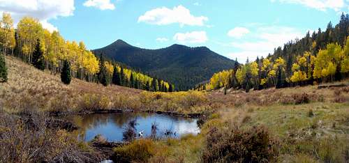
![Aspens reflecting in a pond]() Aspen reflected in a pond off the trail
Aspen reflected in a pond off the trail
3/4 of a mile up the trail we came to a junction with the Ring the Peak trail that circumvents Pikes Peak. Enjoying the views, we continued on ahead for another 1/2 mile until the trail pretty much disappeared in front of some large slabs of rock. I had plotted some waypoints for our route on my GPS, and decided now would be a good time to check our progress. Interestingly, we had managed to walk 1/2 mile in the wrong direction and found our way to Horsethief Falls. Oh well, I guess we just got the extra credit done first.
Bushwacking 101
Making our way back down the trail, we found the Ring the Peak junction and followed it to the north. The trail crossed immediately over a small creek and up into a large open meadow. The aspens along the west end of the valley had already started losing their leaves, but further up into the meadow we were treated with spectacular views of golden aspens, dark green pines, and a blue sky.
The trail wound around the west side of Sentinel offering several photo ops of the guardian of Pikes' western slopes. The further we hiked, the better the views got, and we knew we had picked a winner.
![Sentinel Point]() Karen poses beneath Sentinel Point
Karen poses beneath Sentinel Point![Fall Colors]() Some areas were just breath taking
Some areas were just breath taking
As we continued past the meadow and into denser forest, I noticed we had started to veer off the waypoints I had plotted again. The route description I read mentioned the key to the route was finding a small creek and following a faint trail beside it up through the forest on steep terrain. I had plotted my waypoints exactly per the Topo route posted with the description, so I figured we should do a little exploring for this creek.
![Sentinel Point]()
We bashed across tall grass and around a beaver pond at the end of the meadow and found a small creek on the other side that seemed to follow my waypoints. We meandered back and forth across the stream as we made our way up looking for some sort of trail. Ultimately all we found were a few old fire rings and a deer carcass - hopefully whatever ate that deer was long gone! At this point it was obvious we weren't going to find any trail, and I started to realize that the Topo route I had referenced when plotting our trip had been drawn 1 drainage too far to the south. Being stubborn, we decided to press on and continue bushwacking through the trees following my waypoints. Soon after that, the slope became relentlessly steep. We didn't take many pictures, so just imagine lots of trees & boulders, struggling to breathe, and lots of pain. Our favorite pastime during these experiences is to blame our friend Kevin for everything, because we associate all bushwacking and deathmarches with him - sorry Kevin, we don't really mean it.
![Sentinel Point]() Jim finally breaches treeline
Jim finally breaches treeline
We finally broke through treeline at 11,950' and I was thankful that there was only 600' from the summit, because my quads were on fire. Some storm clouds had started to circle overhead so we were going to have to make a quick push for the summit at get out of Dodge. Safety first, we donned our helmets as the last few hundred feet was a class 3 scramble. We didn't find the easiest route up, but we found a manageable one up the northeast side.
![Sentinel Point]() Sentinel's blocky summit
Sentinel's blocky summit
The views west from the summit were great and we could see the yellow dots and splotches of the aspen all over the place. Fortunately, we met Ray, from Teller County SAR on the summit and he had followed a trail up the correct drainage adjacent to ours on the way up, and offered to show us the way back down - I guess you could call that a sort of pseudo-rescue.
![Sentinel Point]() Views west from Sentinel's summit
Views west from Sentinel's summit
After a few more pictures we headed down the summit pitch and across to the boulderfield to our north. After a few sketchy moves down through some large slabs we worked our way over to the trees on the left border of the boulderfield where we found easy passage down to its bottom. Low and behold we found the cairns that I had read about in the route description...a mere 160 of them placed every 5 feet or so below treeline until the trail became more defined.
Thankful to not be wandering through the woods anymore, we started focusing on the trees again, and they were terrific! A few casual miles and plenty of photo stops later we rejoined the 704 trail and followed it 3/4 of a mile back down to the car. What a great hike!
Cripple Creek
We had heard that the drive up Hwy 67 to Cripple Creek was a fall hotspot loaded with aspen. Plus, I had seen a sign in town about a $5.95 prime rib dinner at Womack's in Cripple Creek. Sounds like the ultimate combo.
![Fall Colors]() Karen on the drive up to Cripple Creek
Karen on the drive up to Cripple Creek
The views along the drive certainly didn't disappoint...amazing what you can find only an hour from home! We made a short stop at the Mollie Kathleen gold mine but waiting over an hour to start the tour didn't agree with my stomach, so we headed straight for Womack's, for the best over-cooked $5.95 prime rib, mashed potatos, and fresh vegetables we've ever had.
![Mollie Kathleen Mine]() Part of the old Mollie Kathleen mine
Part of the old Mollie Kathleen mine
To top off the day, we made it home in time to catch the second half of Virginia Tech's road victory over Nebraska. Go Hokies!


Comments
Post a Comment