Murphy's Law on the journey
My original plans for this summer mountain sojourn had been a two week stay in Colorado in July. Work intervened, but I was able to voluntarily negotiate to postpone the two-week July vacation to a three week vacation straddling the latter weeks of September and the first week of October.
I had hoped to make some substantial progress on the Colorado 14ers this summer. However, getting such a late start on the vacation resulted in some concerns towards the weather, and snow in particular. Still, I had allotted myself a week in the San Juans before heading up to Fort Collins to meet up with an old friend. Afterwards, as the days got colder, it would be westward bound for the desert ranges of Utah and Nevada. Somewhere in there, I had planned to fit in a couple of hikes up Medicine Bow and Bridger Peaks in Wyoming.
A chain of events soon conspired to disrupt my carefully laid plans. On the drive west I popped a tire near Akron, OH. After changing it, I bought a new spare a few miles down the highway. It was not until 200 miles later, after pulling over at a gas stop in Richmond IN, that I realized my debit card was still at the tire place. I called Bank of America, and came to the realization that my options were limited, as I could not get a temp card outside of Massachusetts, and there were no Bank of America locations anywhere in Colorado (or Wyoming, for that matter). A solution was finally worked out where the bank would mail a new card to my friend’s address in Ft Collins. Meanwhile, I would have to wait until Monday in Kansas so that I could withdraw some cash in the meantime.
The extra day in Kansas allowed me to take in the Pats-Jets game at a sports bar in Topeka, as well as finally make the dirt-road detour off I-70 to Mt. Sunflower. It also cost me a valuable day in Colorado, and forced me to cancel my plans for the San Juan Range. Instead, I pushed ahead my agenda for Southern Wyoming, which was much closer to Ft. Collins and that debit card. I arrived finally in Laramie on Monday night as the radio informed me of the shocking collapse of Lehman Brothers, foreshadowing the encroaching economic collapse. (Funny coincidence: it was during my 14er collecting trip of the previous July in which two Bear Stearns Subprime hedge funds collapsed, signaling the beginning of the Great Mortgage Mess of 2007-TBD). As if to mirror the un-auspicious events of the market, as well as the Murphy’s Law which had thus far plagued my trip, my laptop broke, for good, upon arrival at Laramie. It had been a rough trip, and its only saving grace, and my only remedy, would be the good tidings that only the fresh mountain air can bring.
Medicine Bow Peak
![Medicine Bow from Laramie]() Snowy Range from Laramie Snowy Range from Laramie |
![View from near trailhead]() At the trailhead At the trailhead |
![Meadow before gaining ridge]() Meadow near the trailhead Meadow near the trailhead |
![Snowy Range Overview]() Gaining the ridge crest Gaining the ridge crest |
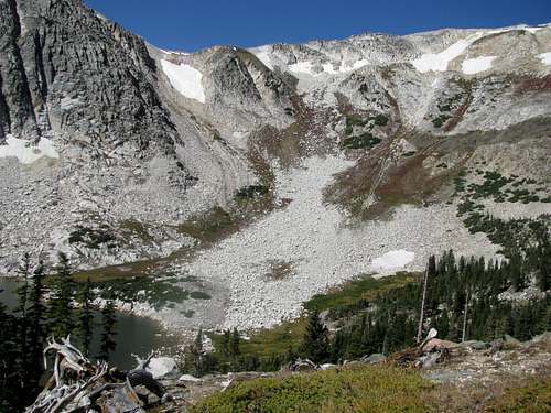
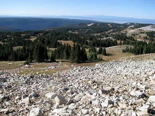
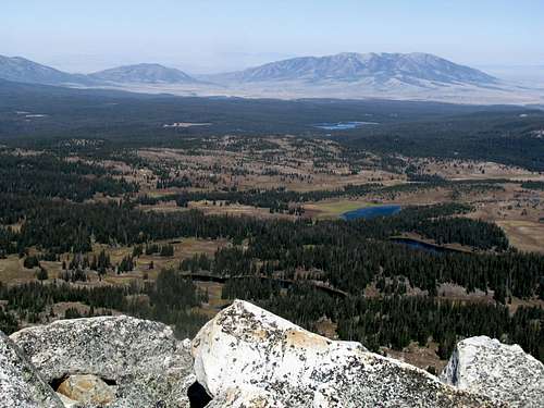
The hike up Medicine Bow Peak was far less eventful than the days preceding it. There was not a cloud in the sky as I left Laramie. The Lake Marie trailhead was well-marked, and soon I was on my way up the refreshing mountain meadows which had now eluded me for more than a year. The trail gains elevation pretty quickly, switchbacking to the crest of the southern ramparts of the Snowy Range. The ascent gets a little rockier at this point, traversing around the rugged summits overlooking Snowy Pass and onto the gentle terrain on the northwestern side of the range. I had expected the route to follow the crest of the range, with views in either direction. To my dismay, the traverse seemed to lose one foot for every two feet gained, and for the most part, stayed level, with the main summits blocking the view back towards Snowy Pass and beyond. There were some scattered patches of snow, but the greatest hindrance was the mud (most likely from recent snowmelt), which made the trail excessively slippery.
The views to the southwest were outstanding, as I got a preview of the Sierra Madre range, my destination for later in the day. Halfway through the traverse, the giant massif of Elk Mountain creeped into sight.
|
|
|
|
|
![Looking down at Lake Marie]() A uneasy drop-off A uneasy drop-off |
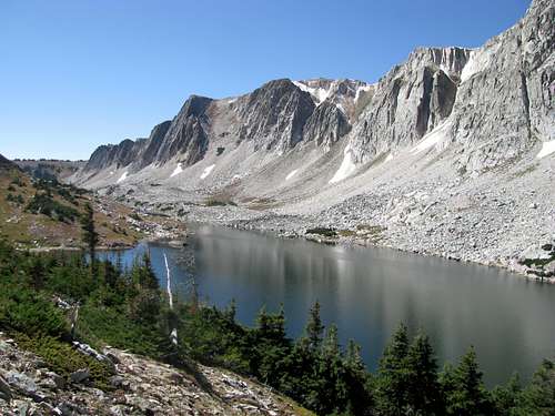
![Gentle terrain]() View of the summit View of the summit |
![Elk Mountain in the distance]() Elk Mountain Elk Mountain |
Finally, with the summit of Medicine Bow within grasp, the trail steepened.
![Medicine Bow Peak in view]() Almost there Almost there |
|
Though I am notoriously inclined to lose a trail, such an occurrence was an impossibility on this mountain, with giant cairns supported by large wooden stakes marking every point of the trail.
![Final push to the summit]() Final push to the summit
Final push to the summit
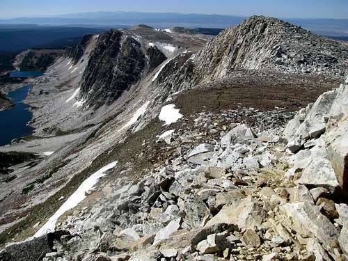
After gaining a saddle between Medicine Bow and its southern, presumably unnamed neighbor, the trail levels off before finally ascending a rocky outcrop to a fairly snug summit. The texture of this last section reminded me, for some reason, of Mt. Sherman (CO), on the narrower parts of that ridge before the top.
|
|
|
![Elk Mountain from Medicine Bow]() Elk Mtn Elk Mtn |
![Sierra Madres to the SW]() Bridger Peak and Sierra Madres Bridger Peak and Sierra Madres |
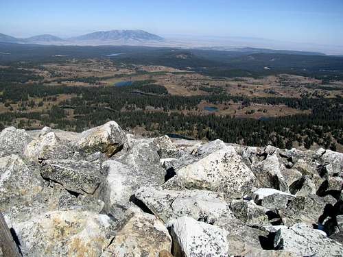
A pleasant surprise was the distant sight of Ferris Mountain, a mountain I am fascinated with and do plan to explore someday. (Also a mountain which is conspicuously missing from this site at present.)
|
|
|
|
|
|
![Zoom of the elusive Ferris Mtn]() Ferris Mountain barely visible Ferris Mountain barely visible |
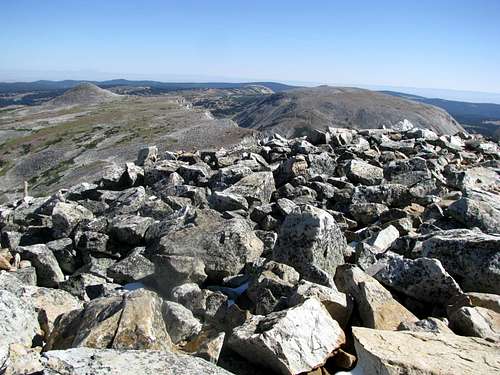
The summit itself was an unstable mass of boulders, lacking an ideal place to sit down and take in the views. Add to the scene the precipitous drop to Snowy Pass uncomfortably within reach, I spent only the requisite time on the summit to down a Cliff Bar and take a few pictures before heading down. Back at that first saddle I bumped into a backpacker on the tail end of a three day trip. After some discussion of mountains and the area, I was informed of the possibility of a loop hike, descending directly from the summit of Medicine Bow and circling around the various lakes on the way back to Lake Marie. This sounded appealing, so I went back up the final stretch to the summit, and we made a quick descent down a good trail towards what I believe is Lewis and Libby Lake.
![Medicine Bow Peak on descent]() Medicine Bow on the descent
Medicine Bow on the descent
Following the main descent the backpacker continued north towards the Gap Lakes, and I head south back towards my car at Lake Marie. I was rewarded for my efforts by great views of the more Alpine aspects to the Snowy Range, and tried with my best efforts to capture this on camera.
The loop thus completed, I continued west down the other side of Snowy Pass, hoping to get a shot a Bridger Peak, about 45 minutes or so to the southwest, before nightfall.
Comments
No comments posted yet.


 Snowy Range from Laramie
 At the trailhead
 Meadow near the trailhead
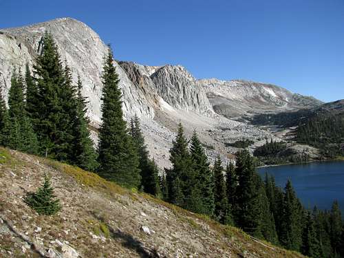 Gaining the ridge crest

 A uneasy drop-off
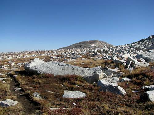 View of the summit
 Elk Mountain
 Almost there

 Elk Mtn
 Bridger Peak and Sierra Madres

 Ferris Mountain barely visible