Your object was successfully created.

-
 3425 Hits
-
 71.06% Score
-
 1 Votes
|
|
Route |
|---|---|
|
|
47.39925°N / 11.68001°E |
|
|
Hiking |
|
|
Spring, Summer, Fall |
|
|
Most of a day |
|
|
not a difficult hike |
|
|
Overview
 Ochsenkopf summit as seen from Stanser Joch (02-11-2008)
Stanser Joch and Ochsenkopf is part of the easternmost Karwendel subgroup, the Rappenspitze - Stanser Joch Ridge. The ridge runs east - west and its southern slopes dip down to the Inn valley at Jenbach, Stans, Vomp and Schwaz. To the north there is Weißenbachtal, Bärenkopf and Achensee valley with the fjordlike lake Achensee.
The east loop of Stanser Joch includes mostly the easternmost part of the ridge, which is a a east - west elongated meadow plateau.
Getting There
 Guffert as seen from Stanser Joch ascent (02-11-2008)
Head to Maurach, as indicates on the Stanser Joch - Ochselkopf site of SP.
At Maurach / Rofan cableway follow the road to Pertisau.
You reach the trailhead if you take the first road left after the traffic circle. It crosses the railways and goes strait to Maurach - Lärchenwiese. At the end of the paved road there are some possibilities to park the car. The road goes on into Weißenbachtal, its a forest dirt road closed to traffic.
Route Description
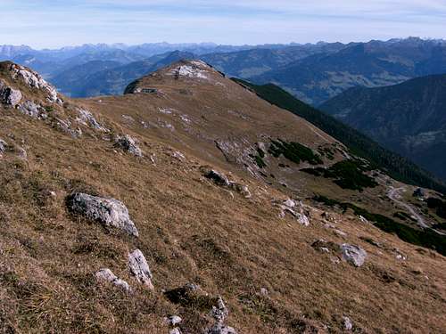 Stanser Joch as seen from Ochsenkopf (02-11-2008)
Follow the forest road into Weißenbachtal. The road gains hight and after several switchbacks you arrive at the private Weißenbachhütte at the beginning of Weißenbach Alm meadow. You pass Weißenbachalm, a nice Alm hut which provides food and drinking for hikers during summer times. The forest road reaches at last Weißenbachsattel (1693 m).
At Weißenbachsattel, follow the trail into Weißenbachkar, the north slope of Stanser Joch - Ochsenkopf ridge. There is a sign which indicates the right trail. This trail winds up on the west side of Weißenbachkar along some interesting rock formations up to a broad saddle in the ridge, which is called "Am Übergang" (2103 m).
There you reach an east - west trail which runs along the ridge.
You may climb Ochsenkopf (2148 m), which is only some 15 min. to the west. Follow the ridge trail to the west and leave it where it traverses the highest parts of Ochsenkopf. Some steps lead you to the summit. Go back to "Am Übergang".
Its another 15 min. from "Am Übergang" to the summit cross of Stanser Joch (2103 m).
To continue the loop follow the marked trail from Stanser Joch to the east. The trail remains on the ridge until it reaches a trail junction:
The left trail descends on the north slope down to Upper Heiterlahn Alm and Lower Heiterlahn Alm. This is a very steep trail and especially in autumn or after wet periods very slippery and not advisable.
The right trail follows the ridge to Weihnachtsegg and Jöchl Alm. At Jöchl Alm trail junction take the left trail wich reaches the above left trail somewhere between Upper and Lower Heiterlahn Alm.
Proceed through thickening forests to another trail junction. Take the left trail until you reach a forest road. Turn left on this road and follow the road until a trail an a sign indicating "Maurach" leaves on the right side. This trail climbes up for some minutes, descends finally to Weißenbach valley and crosses the Weißenbach creek.
Follow the forest road to the left. It climbes up again to reach the Weißenbach Valley forest road. Turn right and you reach the trailhead after some 5 min.
This loop provides wonderful views from the Stanser Joch - Ochsenkopf ridge to the south, north and east. From Ochsenkopf there are some outstanding views of the Karwendel peaks.
Essential Gear
 A Karwendel range vier from Ochsenkopf summit (02-11-2008)
Normal hiking gear and hiking shoes.
In spring there might be still snow, so think about bringing gaiters. As there are some northern slopes involves this hike is advisable from late spring into autumn.
In late autumn the Weißenbach Alm is closed so bring all your necessary food with you. Trails might be icy or slippery wet then.
Books & Maps
The best ones are:Alpenvereinskarte 1 : 25.000, Blatt Nr. 5/3, Karwendelgebirge, Östliches Blatt;
Walter Klier: Karwendel alpin, Alpenvereinsführer, Bergverlag Rother