|
|
Canyon |
|---|---|
|
|
48.87190°N / 116.6254°W |
|
|
Hiking, Mixed, Scrambling |
|
|
Spring, Summer, Fall |
|
|
Overview
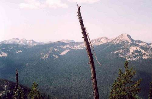
 Long Canyon and Smith Creek from Parker Ridge
 On Parker Ridge
 Smith Peak
Long Canyon is virtually the same today as it was pre-settlement. Despite an increasing human use to the region, it is possible to go there today and see no one or few others. This isn’t a designated wilderness, which perhaps helps it fly under the radar and get fewer visitors. It isn’t deep in a huge subalpine rock and snow wilderness area, but rather an intact system that ranges from high ridges and peaks down to low elevation inland rainforests. The waters of Canyon Creek couldn’t be clearer or the forests any more lush. This is one of the very few places in the U.S. where a full historic complement of wildlife still exists. This little piece of paradise is Long Canyon in the Idaho portion of the Selkirk Mountains.
This deep glacially carved basin runs north from the Selkirk Crest and opens as a giant hanging valley into the Purcell Trench just south of the Canadian border. It is the largest unroaded/unmanaged valley in north Idaho. Some of the highest peaks in the U.S. Selkirks top its ridges and a spectacular ten mile stretch of old growth western red cedar, western hemlock and western whitepine fill the middle of its approximately 18 mile length. Despite being the most remote place in far north Idaho, proposals to designate Long Canyon as a wilderness have failed and politics in Idaho land management have focused on different battlegrounds in recent years. The timber resource is valuable, but the environmental regulations and the cost to access this resource are currently prohibitive of any potential management entries. Given these factors and public sentiments, it is virtually certain that the only changes Long Canyon may ever see are increased hiker use and perhaps a large wildfire someday.
Long Canyon offers a variety of outdoor activities. Most will wish to simply hike through the deep forests and camp in the overwhelming silence. There are a couple trail extensions that allow extended hikes into other parts of the adjacent mountains. These give opportunity for hikers to scramble up some of the spectacular glacial horns that are prevalent in this area. The rugged Selkirk granite also offers highly technical cliffs and big walls on the face of glacial cirques, but with the exception of a few well known destinations, these features are virtually never climbed.
Access
There are three primary ways to get into the canyon.Northern Access (the canyon mouth)
 Near the mouth
 Trail 221
From Bonners Ferry, continue north on Highway 95 for about 16 miles to the Mt. Hall School. Keep left onto Highway 1, (Highway 95 merges right) and continue about 1 mile to the Copeland turnoff (Wallen Road or County Road 45). Turn left and drop off the bench into the Kootenai River Trench and across to the West Side Road. This is a total distance of about five miles from the Mt. Hall School. Turn right on the West Side Road and continue for about seven miles to the Canyon Creek Trail 16 trailhead at the mouth of Long Canyon.
An option is to go only three and a half miles after turning onto the West Side Road to the Parker Ridge trailhead (Trial 14) at the mouth of Parker Canyon. The north end of the Parker Ridge trail (221) ties into Trail 14 about a half mile from the trailhead. This accesses the upper subalpine elevations on the east side of Long Canyon.
Eastern Access
For the first route; from Bonners Ferry, exit Highway 95 into downtown and get on Riverside, the road heading west from town on the south side of the Kootenai River. To find this road just head north a couple downtown blocks and you’ll be there. Continue on this road for about five miles to the Kootenai National Wildlife Refuge. Take a right towards the refuge headquarters on the West Side Road (road 18). The road turns to gravel and continues north along the east foot of the mountains. Continue north on the West Side Road for approximately eleven miles to the Trout Creek road. Turn left and head up the narrow road ten miles to the trailhead.
Follow Trail 13 for half mile to the Pyramid Lake turnoff (Trail 43). Keep right for another half mile to the junction of Trail 41 (which goes right to Trout Lake). Take a left and continue almost a mile to Pyramid Pass. This pass is the east entrance to the canyon. Continue north for about half a mile to the junction of Trail 7, which continues to the left into Long Canyon and Trail 221, which goes to the right and out Parker Ridge. From here one can descend into the deep forest of the canyon or go out the ridge and enjoy the lakes and fantastic views from the subalpine east rim of the canyon.
Western Access
From Bonners Ferry, continue north on Highway 95 for about 16 miles to the Mt. Hall School. Keep left onto Highway 1, (Highway 95 merges right) and continue about 1 mile to the Copeland turnoff (Wallen Road or County Road 45). Turn left and drop off the bench into the Kootenai River Trench and across to the West Side Road. This is a total distance of about five miles from the Mt. Hall School. Turn right on the West Side Road and continue for about nine miles to the paved Smith Creek Road. Take this road and continue approximately six miles to the 2443 road. Follow it nearly seven miles to a gate. Hike on the road for another mile and a half, and then take Trail 17 for another mile up to the ridge. On the ridgeline Trail 17 meets with Trail 18, this runs along the subalpine Smith Ridge forming the west boundary of Long Canyon. There are no trails from the ridge down into the canyon from the west side. A cross country decent would not be advisable due to the rugged terrain unless one really knows what they are doing.
Camping


Camping within the canyon itself is fairly limited. Most suitable places are very nice located in cool forest bottoms near the beautiful stream. However, there are only a few of them, mostly where the trail crosses the water. The first stays on the west side of the canyon about three miles up Trail 16. The crossing at the six mile mark has nice spots as do the crossing at the eight and eleven mile marks. There are probably more places in the central bottoms where the canyon is broad and filled with old growth forests.
There is also camping at Pyramid Lake, just outside the canyon below Pyramid Pass. This is very close to the Trailhead for Trail 13. Parker Ridge, which forms the east boundary of the canyon has good camping at Long Mountain Lake and Parker Lake. Camping at Parker is very limited however.
Peaks
 Smith Peak
 Pk 7445, Parker Pk
 Pyramid Peak
Long Canyon is set among some of the highest mountain peaks in the U.S. portion of the Selkirk Mountains. Parker Peak (7,670 feet) and Smith Peak (7,653 feet) are the highest named points in these mountains and the third and fourth highest overall. Elevations in the canyon range from 7,670 feet at the summit of Parker Peak to less than 1,800 feet at the mouth. There are 12 points over 7,000 feet, with most being on the east side.
Climbing these peaks from the floor of the canyon is extremely difficult due to steep, rugged terrain and insanely thick brush. Trail 7 from the canyon trail (16) connects with the Parker Ridge trail (221) near Pyramid Pass to provide access to the east side. Or it is a short two mile hike on trail 13 from the Trout Creek trailhead to Pyramid Pass. Much of the west side of the canyon is less accessible, however a road reaches much of Smith Canyon to the west and a seasonally open road (2443) climbs the west ridge and ends while still on the west side of the crest, six miles north of Smith Peak. But getting almost anywhere on the west ridge (Smith Ridge) will require cross country travel in often difficult terrain. Refer to the Access section for more information on the trails of Long Canyon.
Inland Rainforest
 Old growth western red cedar and devil's club


The relatively warm and moist climate allows very lush vegetation to occur in the Selkirk Mountains. The flora is strongly maritime influenced as evidenced by numerous coastal disjunct plant species. Elevation is a major influence on climate and consequently on vegetative patterns. The shifts from one forest type to another are controlled at lower elevations primarily by moisture, and at upper elevations principally by temperature. However, it’s not merely elevation, but the topographic features that produce distinct localized microclimate that support complicated vegetation patterns.
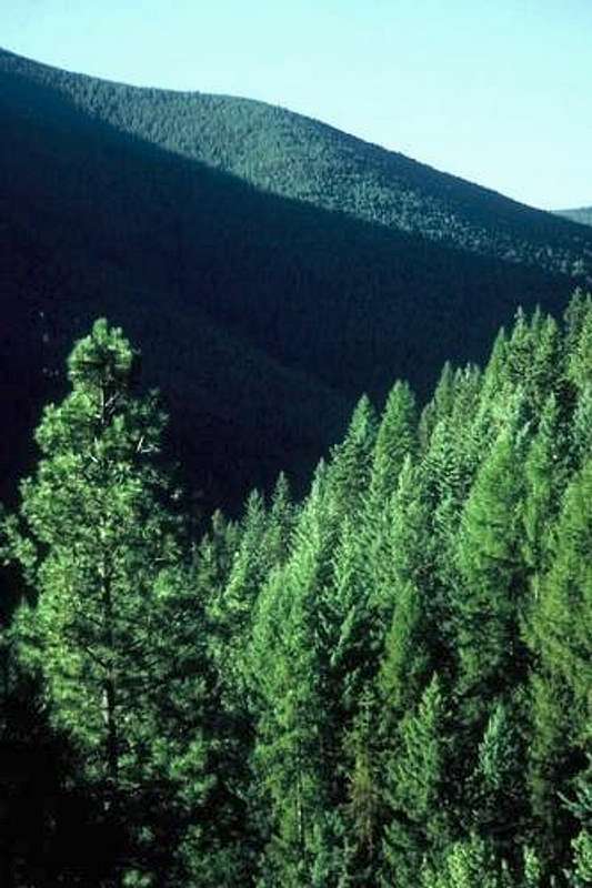
Generally the lower elevations below 4,500 feet are dominated by western red cedar and western hemlock forest. These forest types are especially common in moist bottoms and northern and eastern aspects. In these forests, seral white pine can age over 400 years old, which is young compared to the oldest cedar that may live 1,000 to 2,000 years. On the southern aspects mixed conifers stands of Douglas fir, grand fir, western larch, and lodgepole pine can be found. These forests are fire generated and much younger. Inclusions of ponderosa pine with small grasslands can be found, but are uncommon. Such vegetative communities are due to excessively drained, thin soils often associated with rock outcrops that will not hold enough moisture for denser forests.
At higher elevations the mixed conifer forests give way to forests of Englemann spruce and subalpine fir, but lodgepole pine may be well represented and sometimes form monocultures. These species can also be common at low elevation flats where cold air accumulates. In the highest forests, subalpine fir and whitebark pine dominate the peaks. There is no climatic timberline in the Idaho or Priest Lake Selkirks, but at approximately 6,000 to 7,000 feet, the precipitous rocky slopes begin to preclude forest development. Trees often will continue to grow from cracks and rocky soils, but are generally stunted and very slow growing. At the highest elevations, severe environmental conditions can reduce trees to a dense, tangled mat of ground cover that makes foot travel very difficult. Whitebark pine is a very important component of the higher elevation forests, but disease and insect mortality has converted many of these forests to standing dead.
Water
 Canyon Creek - The jewel of Long Canyon
 Trailside brook
 Canyon Creek
 Parker Lake
 Canyon Creek
 Selkirk Golden Trout
Canyon Creek is an exceptionally beautiful stream. Because the canyon is narrow, there are no substantial tributary streams, yet when Canyon Creek tumbles out of the mountains to meet the Kootenai River, it is a very large stream. The upper and middle elevations are of moderate grade through deep old growth forest, but as it nears the north end of the canyon, several waterfalls form as it flows out of the steep mouth of the hanging valley. Crossing the stream can be difficult, but some searching will eventually find large rocks and logs to fill the need.
There are ten lakes and several small ponds nestled in the high elevation cirques of the canyon and its boundary ridges. Three of these, Canyon Lake, Smith Lake and Cutoff Lake (actually drains west into Smith Canyon) are on the west side, while two lakes, Parker Lake and Long Canyon Lake drain into the canyon from the east. Five other lakes, including Long Mountain Lake, Pyramid Lake, Trout Lake, the upper and lower Ball Lakes and several smaller ponds drain east from the canyon rim. Trails access all the larger eastern lakes, but none go directly to the western lakes.
Most high lakes have been stocked with rainbow, brook, golden and cutthroat trout, but these fish are not native to the high country. Rainbow trout, cutthroat trout and the threatened bull trout are native Canyon Creek. Non-native brook trout are also present and often displace the native trout in the smaller streams. The stocking of brook trout in the high lakes has been discontinued, though not requiring a stream to reproduce, they persist in many lakes. The lakes generally are free from ice only four months of the year.
Wildlife
Long Canyon is the most remote part of the only remaining forest ecosystem in the Pacific Northwest that still has a full complement of native mammals. It is thought that no animal has gone extinct here over the last 10,000 years. Though the canyon is home to a large array of species, there are many notable animals that are listed as endangered or threatened under the Endangered Species Act and others are on the Forest Service sensitive species list.Probably the rarest large mammal in the United States is the woodland caribou that clings to a marginal existence near where the border of Washington and Idaho meets Canada. Introducing animals from Canada in recent years has attempted to reduce the odds of extinction in the U.S. These mountains are also one of the six remaining areas in the U.S. to support grizzly bears. The population is very small at about 35 to 40 animals, but various estimates range from 16 to 75. Wolves have always inhabited the Selkirk Mountains, though for many decades they have been limited to stragglers from north of the border. However, the official 2005 State of Idaho wolf report indicates a pack has formed in the Selkirk Mountains. Lynx and wolverine also make these mountains home, but numbers are very small and individuals seldom encountered. The bull trout also inhabits the larger streams of the lower elevations. These fish are formally listed as Threatened, though populations in the Idaho Panhandle are generally in good condition and most habitats protected. Other wildlife species found in the Selkirks are bighorn sheep, mountain goats, elk, moose, whitetail deer, mule deer, cougar, bobcat, fisher, coyotes and pine marten.
 Woodland Caribou (Burke Museum, Univ. of WA)
Red Tape
There are no fees or permits at this time to access these mountains. However, due to increasing use and demands along with shrinking recreation budgets, use fees could be implemented at some high use trailheads in the future. At some of these, such as the Pyramid Lake trailhead, parking is limited to a few designated places. Once these are full, you’ll need to park somewhere else, though there may not be anywhere else for a few miles. Parking away from a designated place could get you a citation.Additional Information and Current Conditions
Forest Supervisors Office3815 Schreiber Way
Coeur d'Alene, ID 83815-8363
(208) 765-7223
Bonners Ferry Ranger District
6286 Main Street
Bonners Ferry, ID 83805-9764
(208) 267-5561
NOAA Forecast