The page was successfully edited.

|
|
Route |
|---|---|
|
|
46.51200°N / 12.63100°E |
|
|
Hiking, Mountaineering, Skiing |
|
|
Spring, Summer, Fall, Winter |
|
|
Half a day |
|
|
max UIAA II |
|
|
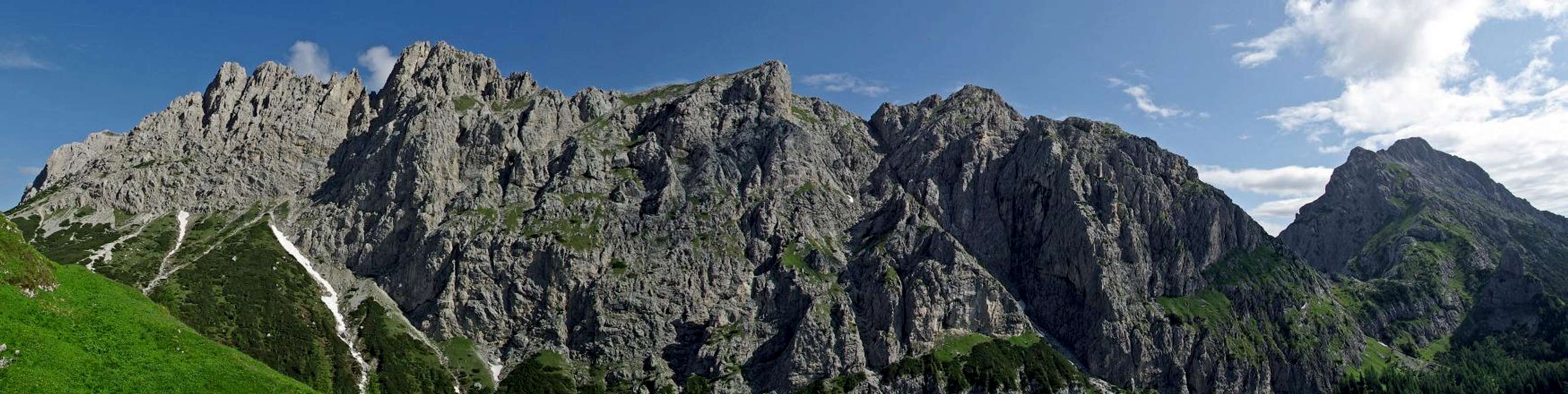
Overview
 On the crest
| face | south-east |
| elevation | 2320 m |
| elevation gain | 800/1100 m |
| Difficulty | max UIAA I until the NE summit – UIAA II to the highest summit |
| Time required | 5/7 hours |
This is definitely not the most popular route of the Southern Carnic Alps, but this doesn’t mean that it’s not beautiful or interesting. Actually in my opinion this could be one of the best choices for somebody who doesn’t know this group and is looking for something not much hard or not too demanding. If you just want to climb the main summit you won’t find technical difficulties, there’s only a short passage around the first degree between Forcella Paradara and the big grassy slope. Also the climb of the north-east summit, that has a better view of the western part of the group and of the Dolomiti, is not difficult, although there’s an exposed passage of the first degree that requires some caution. The climb of the highest summit has alpinistic difficulties around the second degree. The route has been recently marked with red dots until the main summit, that are useful in the first part but completely useless on the grassy slope, because you can see the cross and you just have to go up as you like. It’s not long but quite hard, because once out of the woods the path is really very steep in some parts.
Getting There
The Val Pesarina can be reached either from Tolmezzo ( indications for Villa Santina-Ovaro-Forcella Lavardet ) or from the Cadore ( indications for Vigo di Cadore-Laggio di Cadore-Sella Ciampigotto-Forcella Lavardet ).Route Description
 Malga Mimoias
First you have to reach Casera Mimoias ( 1623 m ) from Pian di Casa ( on the road of the Val Pesarina, after the Albergo Pradibosco, park your car in the parking lot of the Bar situated after the bridge and then follow the indications for the path 201/202, 45 minutes ) or from Forcella Lavardet ( cart track closed to public traffic, very boring approach but with less elevation gain, 40 minutes ).
 Map
Map Approaching forcella Paradara
From there we have to follow the indications for the path that goes towards north-west for the Passo di Mimoias. After the crossing of a small creek, just before the crossroad with the path for the Passo Elbel, turn left and follow a track marked with red dots ( indications on a rock ) that goes up through the woods of conifers. Once out of the woods the path becomes quite steep, and goes up on a small ravine to Forcella Paradara, where the view opens to the majestic walls of Cresta di Enghe and to our goal of this hike, the Creta di Mimoias. From there we have to go down for a few meters ( small spring ) and then go up again through some pines, where we’ll find a short passage where we’ll have to use our hands. The difficulty is around the first degree. So finally we reach the wonderful grassy slope, where in summer we can enjoy the beautiful flowering of many species of alpine flowers.
Now we can clearly see the cross on the summit of the mountain, and we can go up following the red dots or just the line that we prefer. So we reach the East summit of the Creta di Mimoias ( 2288 m, 2/2.30 hours from the casera ).
If we want to reach also the NE summit, we have to go down for a few meters and then again up towards the crest. In this part there’s an exposed passage of the first degree that needs caution. Once on the crest you can follow your own way through the rocks or on the grassy slopes until the summit ( 2301, 10 minutes from the E summit ).
 Terza Grande from the NE summit
The route for the Cima di Mezzo it’s not clear: you should go down to a small notch and then up to the grassy minor summit in front of you. From there you have to go down to another notch ( 10 meters of the II degree, probably this passage needs a rappel ). Then you have to go down following for 50 meters or so a small ravine and from there traverse towards west through exposed grassy and rocky slopes until the base of the summit. Then you just have to follow the crest ( exposed passages of the II degree ) to the top of the mountain ( 2320 m, 1 hour from the NE summit ).
 |