Our Objective
![Mesahchie on right, with Eldorado down valley]() Mesahchie from Easy Pass
Mesahchie from Easy Pass![The Trail to Easy Pass]() Easy Pass
Easy Pass![Fisher and Black Peaks from Easy Pass]() Fisher and Black Peaks
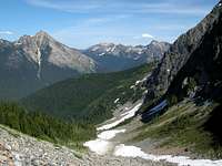
Fisher and Black Peaks![Almost at Easy Pass]() Nearing Easy Pass
Nearing Easy PassTwo of my good climbing buddies, Paul and Walt, and I made an attempt on Graybeard Peak in the North Cascades on Friday, July 17. Graybeard is a very imposing pyramid of a peak visible from the North Cascades Highway (SR-20) east of Ross Lake. The peak itself is very impressive, especially its north face, yet it is only four miles from the highway via the Easy Pass trail. As things would turn out, even these four miles were too much for us.
Graybeard Peak, which has an elevation of 7965 feet, was only recently named by the USGS. It appears as only a point on the ridge on most USGS maps which were created before its name was given. The trailhead, which is located 6 miles west of Rainy Pass on the North Cascades Highway on its south side is easy to find. It is a 3-hour drive from Seattle.
Our first mistake was to arrive at the Easy Pass trailhead at 9:15 which was a bit late. If we had been a fast party, we still would have been OK, but our climbing day happened to be very hot, which slowed us down. The Easy Pass trail is a very nicely laid out trail, which starts in forest, then breaks out into open moraine. Easy Pass is a dramatic setting. It is an area of green meadows and larch trees, with amazing views out to huge Mount Logan and Eldorado Peak, with closer views of imposing Mesachie Peak, Fisher Peak, and Mount Arriva.
Where we went wrong: Having too much confidence in the map and Listening to Beckey
![Mesahchie and Cub Peaks]() Mesahchie, Cub, Honeymoon Hump
Mesahchie, Cub, Honeymoon Hump![Mount Arriva from near Easy Pass]() Mount Arriva
Mount Arriva![Graybeard and the snowy basin]() Graybeard and Snowy Basin
Graybeard and Snowy Basin![Kitling Peak from our Consolation Prize]() Kitling Peak
Kitling PeakEasy Pass is at 6500 feet, and the contours on the map indicates that if you make a rising traverse around the 6800 foot level south of the pass, you can avoid cliffs and in a mile, cross over onto a shoulder of Graybeard. From that point, it is a 1000 foot scramble up the South Ridge of Graybeard until a 25-foot chimney at the top requires climbing and a rope.
Beckey's
Cascade Alpine Guide describes the route as a "rising traverse" south of Easy Pass. As we followed the map and instructions, we were led into a series of cliffs which would have necessiated downclimbing to about 6400 feet into a basin. Hence, this warning. Ignore Fred Beckey's instructions. To climb Graybeard, traverse south from Easy Pass at about the 6400 foot level to find a snowy basin about 3/4 mile south of the pass. Climb the snow to the top to find broken rocks, which will lead you to the South Ridge. From this point, hopefully the Beckey guide is accurate.
As we stood amidst cliffs of a satellite summit of Graybeard, and it was 1:45 in the afternoon, we bowed to the reality of having to shelf this summit for another day.
Our Consolation Summit
![At an impasse]() Gully up Satellite Peak
Gully up Satellite Peak![Fun stuff: Gully climbing]() Climbing Gully up Satellite Peak
Climbing Gully up Satellite Peak![Fisher and Black Peaks]() Fisher and Black Peaks
Fisher and Black Peaks![Forest Fire near Graybeard]() Forest Fire to North
Forest Fire to North![Graybeard and Sub-summit]() Graybeard and our Consolation Summit
Graybeard and our Consolation Summit![Looking north to Mount Hardy]() Mount Hardy down Easy Pass Trail
Mount Hardy down Easy Pass TrailAlthough Graybeard was out of the question for us that day, we were high on the flanks of a satellite summit north of Graybeard. This summit was a worthy objective by itself, probably standing only 500 feet lower than Graybeard. From Easy Pass, this summit is an easy Class 2 scramble from the ridge leading up from the pass. Unfortunately, from our attempted route to get over to Graybeard, we were in a nasty Class 3 gully with lots of loose rock and even some exposure in places. We were able to follow this gully to the summit of this satellite peak, which unfortunately did not have a name, but should have one, since it rises at least 500 feet from all points on the ridge. From here, the views are tremendous.
On our descent, we saw a huge forest fire raging to the north. It was so huge that we could actually see orange flames rising up the hillside in addition to a lot of smoke.
This is a beautiful area, and the opportunities for peak-bagging here are amazing. Fisher Peak, Mount Arriva, Mount Kitling, Mesachie Peak, Cub Peak, and New Morning Peak are all summits that are easily attainable from Easy Pass. For those looking to climb big summits, this is a really prime area. West of Easy Pass, this area lies within the North Cascades National Park, and east of the pass, it lies within the North Cascades National Scenic Byway. No camping is permitted around Easy Pass. Camping is available in Fisher Creek Basin below, but unfortunately, this involves a large loss of elevation.
At the end of the day, even though we didn't summit Graybeard, we felt like we had summited a worthy peak anyway and weren't too disappointed. Even so, when we had gotten back to Walt's cabin in Marblemount, Walt and Paul drowned their trail aches in some Jim Beam.
Comments
No comments posted yet.