
-
 7486 Hits
-
 80.49% Score
-
 12 Votes
|
|
Route |
|---|---|
|
|
34.45522°N / 119.65331°W |
|
|
Spring, Summer, Fall, Winter |
|
|
Add Heading here
 Tangerine Falls Summit Block.
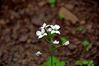 Wild flowers along the trail
 Cold Springs Creek
Being a long time resident of the city of Santa Barbara, California, and having hiked all of the trails in our mountains, you would think that there is nothing left for me to explore. Not so, as I found this trail entirely by accident. It’s not on any map or in any hiking guide books that I have ever seen. Tangerine Falls summit trail must have stayed invisible in plain view. The main reason for escaping attention is that it branches off from a very popular trail that takes you to the base of Tangerine Falls. If you, like everybody else who comes here, want to see the waterfall, you take the lower trail without even looking at any other option.
In contrast to the lower trail that follows the creek and stays deep inside a narrow canyon, the trail to the summit of Tangerine Falls follows an open hillside with beautiful views of ( West Fork of Cold Springs Canyon Trail) and the Pacific Ocean. The trail is excellent and not much more than three miles round trip. You will get a long distance view of the falls near the end of your hike. The summit of the falls is a convoluted rocky area with trees and a running creek. You get a one hundred and eighty degree uninterrupted view of the surrounding area, the town of Montecito, and the Pacific Ocean.
Route description
 Distant view of Tangerine Falls
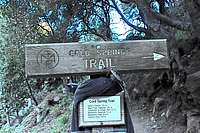 Trailhead
 Take the right fork
 Geo cache on the summit
 Take the left fork here
Start your hike the same as West Fork of Cold Springs Trail. After one quarter of a mile you will see a wooden bench and a rusty old sign marking the point where you need to cross the creek. This creek crossing can be treacherous after a hard rain. But from here on you won’t cross any more major creeks, only minor run-offs from side canyons. About 15-20 minutes up this trail, you will come to a fork in the trail, (refer to the photo).
Take the right fork which passes to the left of a large boulder and a broken pipe. In a minute or two up this trail, you will come to another fork in the trail.There are several short sections of broken pipes next to the trail. The right fork follows an exposed pipe and heads for the creek. The left fork heads up a steep but well-maintained trail. The left fork is the one you need to be on.
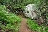
From here, there are no more forks in the trail or water pipeline along it. This trail is excellent and airy. It follows the right side of the West Fork of Cold Springs Canyon for about a mile. After a while the trail heads back toward the narrow canyon that produces the Tangerine Falls. You will have a distant view of the falls.
The end of your hike is the top of a rocky outcrop atop Tangerine Falls. If you wish, you can scramble up a third class section to the highest point of the rocky ridge to see a (geocache) tile.
Landmark coordinates
| Benchmark | Tangerine Falls Summit Trail coordinates | elevation | Distance from trailhead |
 Trailhead Trailhead | N 34.45522--------W 119.65331 | 741 ft | 0 |
 Rusty old sign Rusty old sign | N 34.45900-------- W 119.65414 | 940 ft | .25 mile |
 Take the right fork here Take the right fork here | N 34.46492--------W119.65852 | 1250 ft | .5 miles |
 Summit rocky outcrops Summit rocky outcrops | N 34.47015--------W119.65928 | 1902 ft | just over 1.5 miles |
How to get to the trailhead
From the intersection of 101 and Hot Springs Road in Santa Barbara, California, drive 2.2 miles to it's intersection with East Mountain Drive.Turn left onto East Mountain Drive and drive 1.1 miles to where it crosses Cold Springs Creek. About two hundred yards before the creek you will see a wide turnout on the right side of the road. Park here and walk up the road to the trailhead.
Note: There are two trailheads. The one on the right bypasses the creek crossings and ends up at the Montecito Overlook. The left trailhead follows the bottom of the canyon along the creek. The left trail is the one you should take for Tangerine Falls.