
-
 6372 Hits
-
 85.87% Score
-
 21 Votes
|
|
Canyon |
|---|---|
|
|
34.45290°N / 119.59061°W |
|
|
Hiking |
|
|
Spring, Summer, Fall, Winter |
|
|
Overview


Romero Canyon is located in the Santa Ynez Mountains to the north of the city of Santa Barbara, California.
Romero Canyon is another very popular canyon to the east of Cold Springs Canyon, San Ysidro Canyon and Rattlesnake Canyon. Similiar to its neighboring canyons’ trails, the Romaero Canyon trail climbs gently along a year-round stream, and eventually terminates on East Camino Cielo Road. Camino Cielo Road runs along the ridge separating the Santa Barbara’s front range from its back country.
Directions to the trailhead:
From the city of Santa Barbara take Highway 101 south to Sheffiled Dr exit. Go under the freeway and turn right onto Sheffield. Drive 1.3 miles to East Valley Road. Turn left here then immediately turn right onto Romero Canyon Road. Drive 1.5 miles on Romero Canyon Road to Bella Vista. Turn right on Bella Vista. Drive a quarter of a mile up this road to where it makes a U-shape turn to the right. Find a place to park on the dirt shoulder. The trail starts here.
 Fire Road Gate, start of the hike
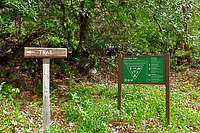 Trail separating from the fire road,
Trail Description:
Start your hike on a steep fire road past a gate. You will soon come to a bridge and shortly after to another fire road that intersects this fire road. Keep to the right here and within two hundred yards you will come to the beginning of the main trail to your left, just under .5 miles from the trailhead. This trail has a sign and an arrow indicating the direction you need to travel. After two miles and three creek crossings the trail intersects with the fire road again. A good place for a break. There is a directional trail sign here. To continue to the top of Camino Cielo Road, cross the fire road and continue on the trail. Another 1.6 miles on the trail will bring you to the highest point on the ridge. If you drop down the other side of the ridge you will see Camino Cielo Road down a short distance. For most people this is the turning point.
If you decide to drop all the way down to Camino Cielo Road where there is a water tank, you can take the fire road back down there by making a loop back to your car.
Camping
Camping one of the creek crossings
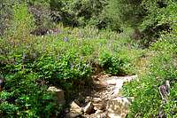
 Looking west from Camino Cielo Ridge Road
Unfortunately, there are no campgrounds close and convenient to Romero Canyon.
There is, however, one very large and well developed campground at Cachuma Lake, and a few less developed ones along Paradise Road off Highway 154. There are also a few campgrounds along Highway 101 at El Capitan State Park and Refugio State Park.
El Capitan Beach Camping
Refugio State Beach Camping
Cachuma Lake