
|
|
Canyon |
|---|---|
|
|
37.17954°N / 112.55965°W |
|
|
Hiking, Canyoneering |
|
|
Overview

This canyon does not require any technical skills to hike through almost all of its narrows, and it does not hold water in potholes. Getting to the canyon requires some cross-country desert hiking through the Sand Hills.
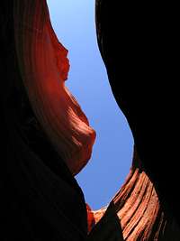
Red Canyon has beautiful, deep red narrows carved in the Navajo sandstone of the Glendale Bench formation. Portions of its narrows are 100 feet deep.
Getting There
Red Canyon is between Kanab and Mt. Carmel Junction on US89. To find the parking area from Mt. Carmel Junction, drive until you find the road for Coral Pink Sand Dunes State Park on your right (south). From here, a secondary road leaves US89 one mile east of the Sand Dunes State Park road. This secondary road is partly paved and partly dirt, and parallels US89 for four miles before meeting the road again. This is the parking area. You can also drive along US89 for the four miles and park, but there are a few other secondary roads in the area, so ensure you're in the right place. The parking area can accommodate about 10 cars.Route
 Topo Map
If you choose to go cross country, use your compass to travel nearly due north for one mile to the canyon across the Sand Hills. There's a bit of up-and-down through the sand, but it's an interesting hike. Once you reach the canyon, find an appropriate way down into the wash that leads to the narrows.
Follow the canyon wash west to the narrows entrance. The narrows are about a mile long, and end abruptly at a 20 foot overhanging chockstone obstacle. I've heard that the narrows end shortly after this obstacle, and the canyon just gradually widens. Getting to the chockstone obstacle requires no technical skills, and there is usually no water in this canyon unless it is just after a storm.
richardpattison - Jul 9, 2022 8:57 pm - Hasn't voted
TrailheadThe trailhead is between mile posts 72 and 73 (roughly 72.6) on US89. The trailhead is marked on US89 with a brown sign "Peekaboo Trailhead" and also a yellow "ATV X-ing" sign. The large parking lot/ATV staging area is 50 yards off US89, with picnic tables, info board and toilet.