
-
 3162 Hits
-
 74.01% Score
-
 4 Votes
|
|
Route |
|---|---|
|
|
47.45495°N / 10.33012°E |
|
|
Download GPX » View Route on Map |
|
|
Hiking, Skiing |
|
|
Spring, Summer, Fall, Winter |
|
|
Half a day |
|
|
Hike, Ski or Snowshoe tour |
|
|
Overview
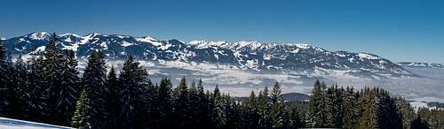
 Sonnenkopf, Heidelbeerkopf, Schnippenkopf and Rubihorn seen through the valley fog from Altstädten Sonnenkopf, Heidelbeerkopf, Schnippenkopf and Rubihorn seen through the valley fog from Altstädten |
There are several routes to the three Sonneköpfe summits, Sonnenkopf, Heidelbeerkopf and Schnippenkopf. The two most important and popular ones start at Altstädten in the north-west or at Reichenstein in the south-west. They are connected by the Sonnenköpfe Ridge traverse, popular in summer, far less done in winter. The traverse is a popular ski tour and snowshoe destination, advertised as one of the must-dos in winter on the Oberstdorf and Fischen web sites.
The northern branch of the traverse, the ascent (or descent) from Altstädten follows mountain dirt roads for much of the time. The roads end above Altstädter Hof, from where path lead across the summits. As the mountains are grass covered but steep, the most demanding parts run through deep ruts. No fun in wet conditions.
Getting There
 Hörnergruppe seen across the Iller River from Altstädter Jof
- Take motorway A8 to the intersection Kreuz Ulm-Elchingen.
- Turn onto motorway A7 south, direction Kempten and Füssen.
- At the intersection Dreieck Allgäu switch to A980.
- A few km later turn onto B19, direction Oberstdorf.
- At Sonthofen switch to OA4, direction Altstädten.
Route Description
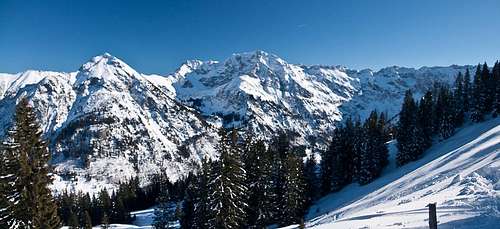
 Heidelbeerkopf and Schnippenkopf seen from Sonnenkopf
- Start altitude: 775m
- Summit altitude: 1767m
- Prevailing exposure: N, W and E
- Type: Hike, ski and snowshoe tour
nbsp; - Protection: None
On OA4, the road which connects Oberstdorf with Sonthofen on the eastern side of the Iller River, there is a parking lot some 1km south of Altstätden. Walk north beside the road until you reach a depression, in which a side road turns off to the right (east), even before you reach the village. The road passes a small lake, then ascends across the meadows around the village. A few hundred metres onwards, at an intersection, take the northern road, which bends eastwards and starts to ascend steeply. In winter it is often used as sledding slope so take care.
Follow the road for a while until you reach a signpost at an intersection. The sign warns of military training grounds ahead, so take the road to the right. It passes a meadow to the right, then turns south through a small forest. To the left a side road turns off, go straight instead until the road leaves the forest. Here Altstädter Hof becomes visible and the road leads in two wide bends toward it.
  |
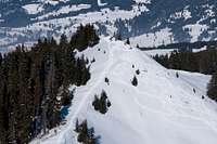
Above the farmstead the road turns into a path, which ina another wide bend leads across the pasture, then starts climbing steeply to a shoulder, where it joins another dirt road. This road leads to the Sonnenköpfe ridge, which it reaches in the saddle between Sonnenkopf and Gehrenkopf. Cross a small depression across a meadow, then startclimbing the ridge, which soon turns very steep. The rutted path winds beside a cattle fence, beyond which the ridge drops steeply into Retterschwanger Tal. Finally, al wooded shoulder is reached, where the route from Hinang (and a shortcutting route from Altstädten) join.
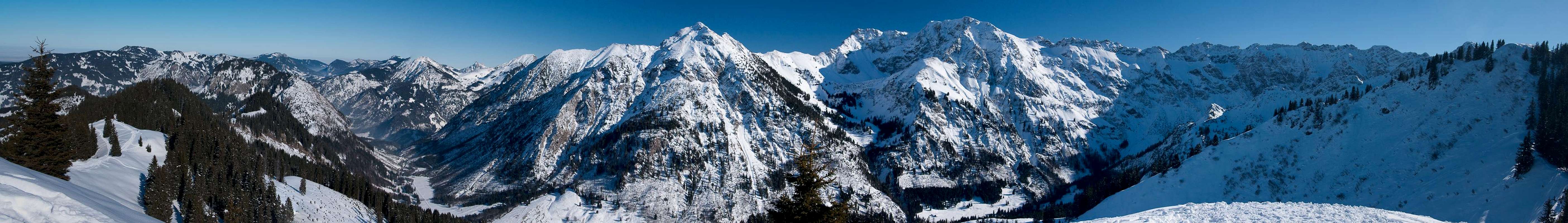
 Rotspitze and Grosser Daumen from the shoulder to Sonnenkopf
With a little up and down the path leads across the shoulder towards the north ridge of Sonnenkopf, where the ski route route from Hinang joins. Hike up the broad ridge to the summit of Sonnenkopf.
 |
From here a short descent leads into a saddle, from where the Heidelbeerkopf north ridge starts. It is very steep, the track is rutted and leads very closely by the drops on the eastern side of Heidelbeerkopf. While not really exposed, this section can be very uncomfortable in wet conditions or without proper equipment in winter. The traverse to Schnippenkopf passes Heidelbeerkopf some 40m to the west of its summit and a few steps take you to the top.
 |  |  |
not done by me:
For Schnippenkopf you need to descend steeply into the next saddle, from where the path winds across the broad, steep north ridge to the highest mountain of Sonnenköpfe. You lose some 150m of elevation before reaching the sadlle and starting the final ascent.