
|
|
Area/Range |
|---|---|
|
|
23.44479°S / 65.29573°W |
|
|
Hiking, Mountaineering, Sport Climbing, Bouldering, Scrambling |
|
|
Spring, Summer, Fall, Winter |
|
|
13386 ft / 4080 m |
|
|
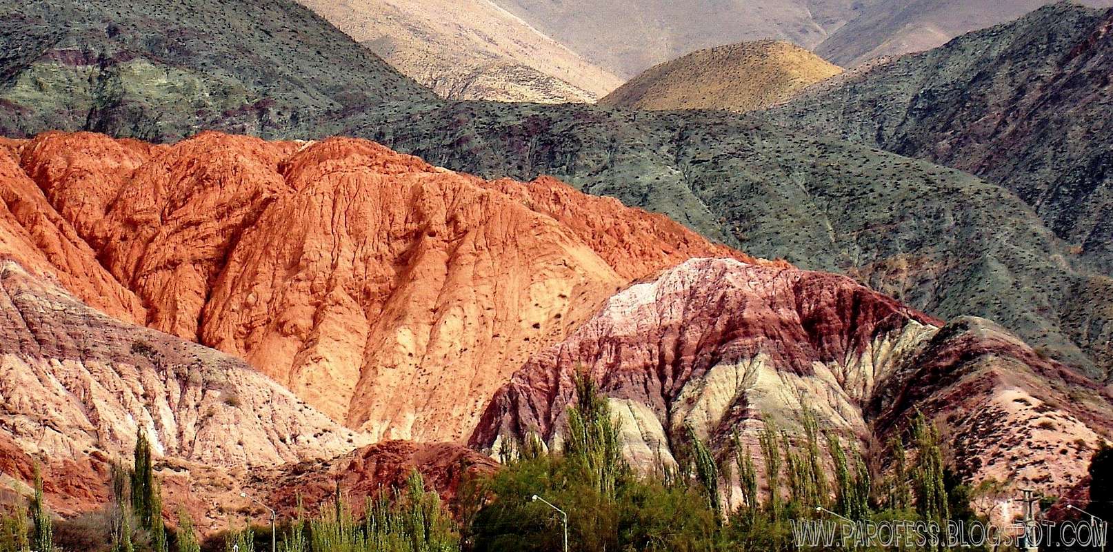
Cerro de Las Siete Colores
Just 130 miles outside of Salta, you'll find the SMALL yet beautiful village of Purmamarca. With a name that translates to "Town of the Virgin Land" you'll be taken aback by the untainted quality of the terrain, bound by the Rio Purmamarca to the north and the picturesque hill of seven colors to the west. With a local population fluctuating between three and four hundred residents, as well as remnants of original 17th century architecture, this village is truly a relic of ages past.
Attractions at Purmamarca are plentiful. Whether you choose to visit the Saint Rosa's church at the center of town, built in 1648 and featuring original Cuzco School style paintings, or the neighboring archaeological sites littered with cave paintings, you will undoubtedly be touched by local flavor. Furthermore, visitors should not be surprised to wake to sounds of local musicians who often line the streets and fill the air with improvised musical performance. Also, handicraft fairs color the village streets, with clothing, crafts, ponchos, and woven cloths available for purchase.
The village is surrounded by several mountains that can reach over 4000m high, with plenty of mountaineering potential. I've been there twice already but never with time to stay over and do some stuff. Next time i will.
Getting There


Best thing to do
Purmamarca has a relatively mild climate, most are comfortable enjoying the area on daytime hiking or horseback riding excursions. Additionally, the Paseo de los Colorados marks a gorgeous three-kilometer walk that features naturally sculpted red cliffs and a series of breathtaking views. Purmamarca is one of the most picturesque villages in the Humahuaca Ravine. Its name means “the lion's village” in the Quechua tongue and little is known about the exact dates on which the first settlements occurred.It happened thousands of years ago. This obvious remark is ratified by the countless amount of objects still being discovered in the outskirts of the village, as well as in the surrounding hills.

Mountains of Purmamarca!
The most outstanding, which has made the city that lodges it so popular, is the hill of the seven colors (Cerro de las siete colores). It bears such a name due to the various pigments aquired by the minerals that make up its walls. This hill is part of the eastern mountain range and is located right West of the population nucleus of Purmamarca. It is best seen from the main road we took after having left Route 9 in our way to the surroundings of the hill.
Resulting from a complex geological history, the layers of various colors have been formed by the accumulation of sea, lake and river sediments which have been deposited on the region for over 600 million years and which have later influenced the apparition of these mountains in the location they have today as a result of tectonic movements.
Its beauty has turned it into the representative postcard of Northern Argentina in almost all the corners of the world where tourism in our country is promoted. The best moment of the day to watch it is from dawn until noon, when the sun reflects the appropriate light on the mountain so that none of the pigments goes unnoticed by the human eye.
There is several routes to hike Cerro de Las Siete Colores and quite easy ones. But the best thing is to cross the road to the outskarts of the city to photograph it!
Camping
Several places to camp with all the help you can get, or wild camping if you want to as well.Campings and contacts:
7 Colores - Ruta 52 - Acceso A Purmamarca: (387) 4211736
Bebo Vilte - Salta S/n: 4908038
Camping El Poro - Pantaleón Cruz S/n: 4908003
Camping Cabañas Mirador del Virrey
Ruta Nac. N 52 Km 4,4
4618 - Purmamarca
Noroeste (Argentina)
GPS: -23.72486 -65.52268
Weather forecast
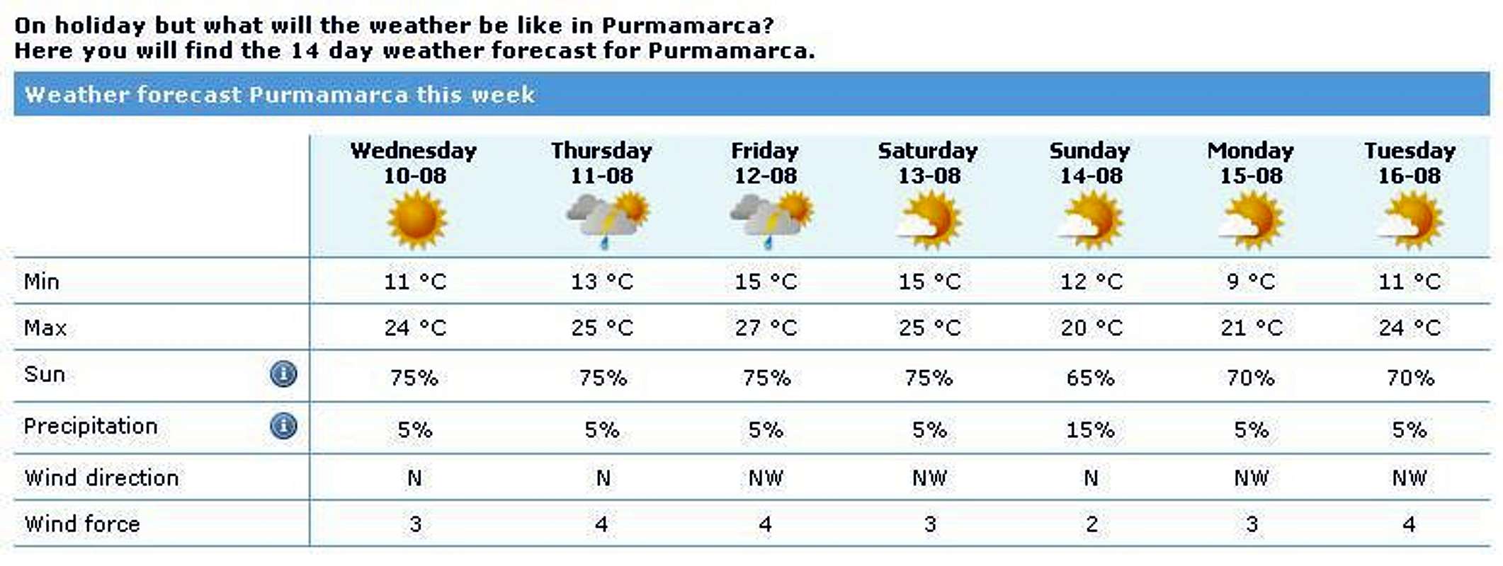
IMAGE AS A LINK TO WEATHER FORECAST WEBSITE
Legal Issues
To hike/ climb is a dangerous activity and requires proper equipment and clothing, the owner of this page cannot be blamed by injuries caused to anyone who read this page for its info about the mountain, and eventually got hurt by doing so with reckless behaviour or bad weather conditions.
Paulo Roberto Felipe da Silva – AKA: PAROFES
External Links
A brazilian website to get mountains info, including gps files to download:http://www.rumos.net.br/rumos/My youtube channel: www.youtube.com/parofes - Now with 250+ videos online!
The biggest brazilian website about climbing and mountaineering, for which I'm a columnist:
Baarb - Oct 29, 2011 5:23 pm - Hasn't voted
PhotosHi, I have lots of photos from the Paseo de los Colorados if you think they would be a good addition. It might be worth noting there are buses to and from Jujuy and the ones to Jujuy from Purmamarca may leave earlier than those posted times if the driver feels like it. One might have to change buses half way also.
PAROFES - Oct 31, 2011 6:09 am - Hasn't voted
Re: PhotosHello Baarb! Well, if you have tons of photos, fell free to add them to the page, it will be great to contribute to it! Cheers Paulo