Gobbler hike, Turning on our beast mode
My buddy Chris and I have been hiking for awhile now. We usually go to a new spot every weekend and conquer something. We planned on going ot the Mormon Rocks and just running around but I decided to switch it up on Wednesday after coming home from my 1.5 year olds doctor appointment in San Bernadino. Noah fell asleep on the way home and I figured hey let the lil guy sleep. So after exiting the I-15 freeway I turned onto Lone Pine Canyon road. The view was awesome and at that moment I instantly changed my mind on our hiking adventure for Sunday. I had purchased a Tom Harrison Topo map of the surronding area from Sports Chalet. When I got back to the house the research began on our conquest. After studying it for a minute I found a route that would take us right up to Gobblers Knob campground and then we meet up with the Pacific Crest Trail all the way to Wright Mnt. The road (3N31) was a good 2-3 miles up itself. It had a couple of nasty hairpin turns but it was going to be our savior for the hike. The hike was supposed to be 5.5 miles one way. I love that saying "supposed to be". Well it wasn't 5.5 at all, ended up being well over 10 miles. Here is the story that insues, it was a very fun trip. It was also trying, long, hurtful, laughable, windy, warm on one side, cold on the other, clouded, and of course many boulders rolling down the side of the mountains. The morning of Gobble Gobble
![Gooblers Knob]() Element sadly parked by Lone Pine Canyon Rd.
Element sadly parked by Lone Pine Canyon Rd.
2. My dog ate my power chord to my phone/alarm clock. I had the wife set the alarm for 0630
3. She set it for 1830 instead which I woke up 30 minutes late. Our trip was pushed back by almost 90 minutes.
4. Chris had played 3 softball games back to back to back on Friday and was already tuckered out. He trucked on like a soldier anyhow.
5.* This is the kicker here, the gate from the turn off of Lone Pine Canyon Rd. to 3N31 was friggin locked!!
This means we have to hike the whole entire road to the start of the PCT!! We did not see that coming. Someone throw a wrench....now!! There is a reason they say to call ahead talk to the Ranger station to see what the weather conditions are and see if roads are open. I figured since the winter has been so warm we could come and go as we please. Ummm yeah not so much.
![Gooblers Knob]() I call this "my" Hells Gate!!
I call this "my" Hells Gate!!And we're off....
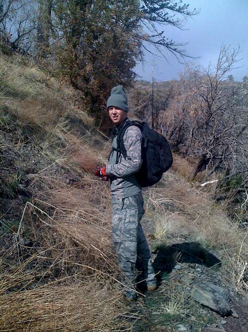
![Gooblers Knob]() Chris after we discovered our demise
Chris after we discovered our demise![Gooblers Knob]() The road leading to Gobblers Camp ground
The road leading to Gobblers Camp ground....Gobblers Knob, finally!!
![Gooblers Knob]() Our real adventure begins....
Our real adventure begins....![Gobblers Knob]() Me at the start of the PCT
Me at the start of the PCTMission PCT is a go
![Gobblers Knob]() Blocking but not preventing our route
Blocking but not preventing our route![Gooblers Knob]() Looking back to Lone Pine Canyon Rd.
Looking back to Lone Pine Canyon Rd..
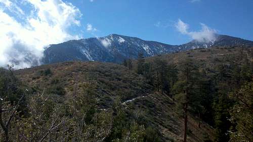
![Gobblers Knob]() Dawson Peak (left) & Pine Mnt (right)
Dawson Peak (left) & Pine Mnt (right)![Gobblers Knob]() Hang Mans Noose Mountain
Hang Mans Noose Mountain![Gobblers Knob]() Clouds a planty this day
Clouds a planty this dayOnward to Wright Monutain My Friend
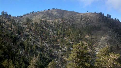
![Gooblers Knob]() Small snow for Feb
Small snow for Feb![Gooblers Knob]() Just simply amazing
Just simply amazing![Gooblers Knob]() Crazy Tree
Crazy TreeSummit Success....well to us it was and that's all that WE care about.
![Gobblers Knob]() Keep on trucking to the ski lift fella
Keep on trucking to the ski lift fella![Gobblers Knob]() Looking out toward Victorville/Phelan
Looking out toward Victorville/Phelan![Gobblers Knob]() Chilling and looking into the Mojave
Chilling and looking into the Mojave![Gobblers Knob]() Feet hangin and danglin
Feet hangin and danglinHomeward bound and tick down
![Gobblers Knob]() PCT back to home
PCT back to home![Gooblers Knob]() Wright Mnt. signature
Wright Mnt. signature![Gobbler Knob]() Valley of 3N31
Valley of 3N31![Gobbler KNob]() This was faster but very trecherious
This was faster but very trecherious![Gobblers Knob]() Tick Ridge....ahhh!!
Tick Ridge....ahhh!!Red Tape
Directions
From Palmdale take Ave S to CA-138 to CA-2 to Wrightwood to Lone Pine Canyon Rd (this road breaks up and you take Sheep Rd. to Thrush Rd. to get back to Lone Pine) to 3N31.
Red Tape
All you need is a Adventure pass, daily or annually. Cmon people get out there and be apart of nature before it's too late!!
Comments, questions, or concerns hit me up
Peace I'm out


Comments
Post a Comment