
|
|
Route |
|---|---|
|
|
40.78901°N / 110.05674°W |
|
|
Hiking |
|
|
Summer |
|
|
A long day |
|
|
Class 2 |
|
|
Overview
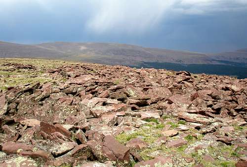
This route page describes a loop hike that goes over four 12 thousand footers and one 11 thousand footer located in the eastern Uintas of Utah. Virtually all of the hike is above tree line, with about 3.5 miles along the main east/west Uinta crest. Great views are had in all directions, in particular of the Kings-Emmons ridge to the west. It is extremely unlikely that you will encounter anyone else on this hike. View of Kings-Emmons Ridge
The four 12 thousand footers are "Walk Up Peak" (12365), "Taylor Peak" (12620), "East Burnt Fork Peak" (12666), and "West Burnt Fork Peak" (12666). Of these, "East Burnt Fork Peak" has over 300' of prominence while the others have at least 200'. None of these peaks have official names.
The 11 thousand footer is unnamed Peak 11896 which is so obscure that as far as I know it does not even have an unofficial name. Even so, according to listsofjohn it is number 96 on the list of the 100 highest peaks of Utah. "East Burnt Fork Peak" comes in at number 36.
The hike is almost all off-trail and will be a long day for the average hiker. However, it is not technically difficult and any fit hiker comfortable with off-trail hiking and having good navigational skills should do fine.
 "Walk Up Peak"
 "Taylor Peak"
 "East Burnt Fork Peak"
 "West Burnt Fork Peak"
 Peak 11896
Getting There
See the Getting There section for Peak 11896.Stats
Length: 16.5 miles RT (2.8 miles on trail, 13.7 miles off trail)Total elevation gain: 3460 feet
Highest elevation: 12666'
Start elevation: 10460'
Time: It took me 9 hours and 48 minutes round trip
Route Description
It is expected that the reader will correlate the written description with the map.Even though most of the route is off trail, much of it is as easy to walk on as if it were a trail either being comprised of easy walking tundra or wide open forest with minimal deadfall. However, it is virtually impossible to escape boulders in the Uintas so you will see plenty of those too.
The route starts out following trail #133 which branches off of the road to Chepeta Lake. The map shows this trail starting at N40.76858 W110.0252. That location is a little off. I found a sign for the trail a little north of that point at N40.76937 W110.02338. However, there wasn't much evidence of any trail heading west. I saw one big cairn which I walked to and then didn't see any thing else to indicate a trail, no trodden path, no more cairns, nothing. Therefore, I didn't see any point at starting at that particular location and chose to start where the road made a bend putting me as close as possible to where I wanted to go. There is a very nice parking spot at N40.76794 W110.02695 from which I started.
I headed off in the general direction of where the trail was supposed to be and soon encountered a large cairn at N40.76846 W110.03172 and from there the trail was obvious, either marked with stakes, cairns, or well trodden.
Follow the trail until just past where the Highline Trail is shown joining it on the map. I did not notice this intersection while hiking.
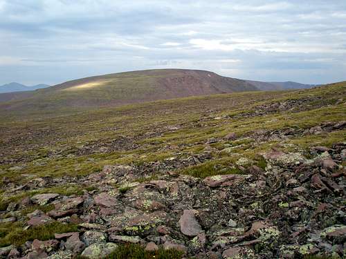 Looking ahead to "Taylor Peak" while approaching "Walk Up Peak"
Head north to Walk Up Peak (12365'), passing to the west of minor Point 11446. The first .7 miles or so of this section rises very gently until treeline is reached. Then there is a steep 300 vertical foot section of jumbled rock (class 2+) to make your way through, followed by a mix of grass and boulders. As are the other peaks on this route, "Walk Up Peak" is very flat on top and it is hard to tell where the actual top is.
Once you get to "Walk Up Peak" simply head west along the broad main Uinta ridge crest to "Taylor Peak", "East Burnt Fork Peak", and "West Burnt Fork Peak". The ridge is an easy class 1-2 walk with gentle grades. The terrain is a mix of grass and boulders. Note the weather station between Walk Up Peak and Taylor Peak.
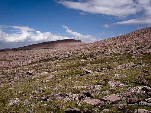 Looking back at "West Burnt Fork Peak"
From West Burnt Fork Peak head southeast across the south shoulder of East Burnt Fork Peak at about the 12300' level. Continue southeast to about the 12000 foot level where you will pick up a trail. Follow the trail in the general direction of Point 11896 for about a mile or so until the trail diverges. Continue cross country to the summit of Peak 11896 where you will find a large carefully constructed cairn and a benchmark.
Backtrack almost to the saddle with 11689. As you approach the saddle, start contouring around to meet the east ridge of 11689. Follow the ridge until treeline and then make a beeline for your car.
Note, at the beginning of August, I found the swamp shown on the map (near the road) to be dry enough to walk through. In the beginning of summer, you might want to stay to the south of it when heading back to your car.
Essential Gear
Standard hiking gear.Mountain Weather
 9:44AM, 30% chance of scattered thunderstorms after noon
As this hike is mostly above treeline and along ridgelines with no available shelter, you need to be especially wary of thunderstorms. A summer day in the Uintas with no predicted chance of thunderstorms is hard to find. However, there are typically 1 or 2 days per week where the chance is only 20%. In my experience, a 20-30% chance of thunderstorms means that you are virtually assured of witnessing one but you have a reasonable chance that it won't be directly overhead, and a 40% chance means that your are virtually assured of being in the midst of the storm if you are still out in the afternoon. There is no "maybe it will be ok", it won't be.
Here is a link to the current 7 day forecast for the area.