Liechtenstein from North to South
In 2012 I spent almost the whole summer in the Alps. Coming from sea level, I needed to get acclimatized before I could go high up. I had been to all the larger countries in the Alps, but not to the smaller ones.
In a couple of weeks, I would meet some a few other climbers in the Ötztal region in the west of Austria, which meant Liechtenstein was close. So, I traveled to the Ötztal, dropped some of my gear and with a small pack I headed west.
To be precise, I took a train to Feldkirch (455m), an Austrian town on the border with Switzerland and just north of Liechtenstein. From there I started walking south, and up, because I didn't just want to traverse Liechtenstein from north to south, I wanted to explore the mountains!
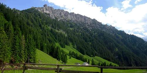
![A marvelous ridge]() Drei Schwestern (2052m), Garsellakopf (2105m) and Kuegrat(2123m) from the Gafadurahütte. Traversing this ridge is quite popular, and a whole lot easier than you might think. You need to be able to handle the exposure and use your hands occasionally, but no climbing is required.
Drei Schwestern (2052m), Garsellakopf (2105m) and Kuegrat(2123m) from the Gafadurahütte. Traversing this ridge is quite popular, and a whole lot easier than you might think. You need to be able to handle the exposure and use your hands occasionally, but no climbing is required.The start
The first day was a short one. I hiked via the Sarojasattel (1626m) to the Gafadurahütte (1428m), one of the two alpine refuges operated by the Liechtenstein Alpine Club. It was a nice day for a walk and I had good views. Well after arriving in the refuge, the heavens opened.
The Fürstensteig
Day two I hiked (and used my hands a couple of times) on the traverse of the fine ridge extending from the Drei Schwestern (2052m) across Garsellikopf (2105m) and Kuegrat (2123m) and beyond. This route is called the Fürstensteig and it's known as one of the best alpine hikes in the country. The route was fun, but unfortunately the low clouds meant that I couldn't see far. Only on the highest parts of the route did I find myself above the clouds.
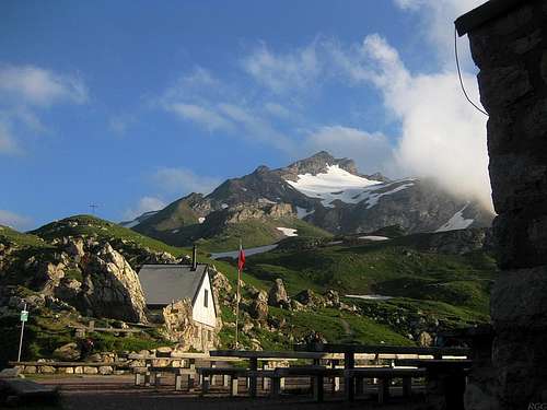
I continued down towards Steg (1301m), and a few hundred meters down visibility improved, as I was now under the clouds. After a nice meal in a local restaurant, I hiked up again in the Valünertal, to the Pfälzerhütte (2108m), the second refuge by the Liechtenstein Alpine Club. It's on the eastern border with Austria, and very close to the southern border with Switzerland as well.
![Naafkopf from the Pfálzerhütte]() For most of the day, the Naafkopf had been in the clouds, but early in the evening they finally lifted. I hoped for that, but didn't expect it to happen. When it finally did, I practically raced to get up there before darkness!
For most of the day, the Naafkopf had been in the clouds, but early in the evening they finally lifted. I hoped for that, but didn't expect it to happen. When it finally did, I practically raced to get up there before darkness!Watching the clouds
The third day brought more clouds. I waited for improvement, which came slowly. After a few hours, the cloud level had crept up enough to see something. I headed out and I left for a day trip down to Malbun. As I had hoped, the clouds kept rising, so I came back to the refuge using the high way, over the Augstenberg (2365m). Only by late afternoon, the clouds finally disappeared almost completely, and the highest mountains appeared for the first time. I paid an unplanned quick visit to Naafkopf (2570m), the third highest peak in Liechtenstein. I made it back just after sunset.
The Liechtenstein country high point
The fourth day was the best. Although I don't consider myself a collector of country high points, when I'm near one, I like to climb it. Since the country is so small, you're almost by definition near its high point whenever you're in Liechtenstein. It is the Grauspitz, more specifically the Vorder Grauspitz (2599m). It's on the southern border with Switzerland. In fact, it's easier to climb from the Swiss side than from Liechtenstein. Before the trip, I had read a bit about it, and I planned to do it from Liechtenstein, but there was one crucial section along my intended route where I knew I might have to change my plans. I would decide what to do when I got there.
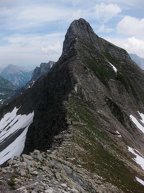
![The steep west ridge of Schwarzhorn from just west of the Grauspitzsattel]() The west ridge of the Schwarzhorn, which I had just descended, from the saddle with Vorder Grauspitz
The west ridge of the Schwarzhorn, which I had just descended, from the saddle with Vorder Grauspitz![Steep down climbing on crumbling rock awaits me on the west side of Schwarzhorn]() Until now I had postponed the decision whether to climb down this steep crumbly ridge, or make a detour. I figured I would have a closer look and then make up my mind. It didn't look too too bad, so I climbed down.
Until now I had postponed the decision whether to climb down this steep crumbly ridge, or make a detour. I figured I would have a closer look and then make up my mind. It didn't look too too bad, so I climbed down.Then, in the Pfälzerhütte, I was fortunate enough to meet a friendly local climber, who knew a whole lot about the area, and my intended route. He explained everything I wanted to know. The crucial point on my route would be the descent of the Schwarzhorn (also know as Hinter Grauspitz (2574m)) west ride. I had seen photos and read about it, but couldn't really find out how hard it would be. He told me it was UIAA grade II, very exposed, and poor rock.
Well, depending a bit on the circumstances, I'll be happy to scramble up and down grade II, and I don't mind exposure. But poor rock is a different matter. I knew more now, but still I would decide if I would climb down that ridge or not when I got there and could see it for myself. The alternative would be a detour, well down from Schwarzhorn on the Swiss side and back up a steep talus field to the Vorder Grauspitz. It would be less exposed and less dangerous, but take longer and more energy.
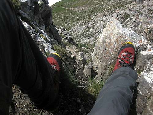
When I got on the Schwarzhorn and looked down from the summit, I could only see part of the route. Knowing it would not get harder than grade II was very useful. I knew I wouldn't be climbing myself into a jam because it would get too difficult. It was very exposed, as predicted, but I saw plenty of holds, and places to put my feet. I carefully descended, testing every rock to see if it might give way. Some were loose indeed, but it wasn't totally bad, and gradually I got down the ridge. After that, it was plain sailing to the Vorder Grauzpitz.
From there, I planned to go the Schesaplana refuge, well to the east, in Switzerland. The local climber had helped me out again by telling me that the best way would be to go over Schwarzhorn once more for that, and so I scrambled back up that same exposed ridge.
Looking up, I was impressed. I was really glad I had already descended it, so that I knew that it was easier than it looked, or I might not even wanted to go up there. That's how steep and exposed it now appeared!
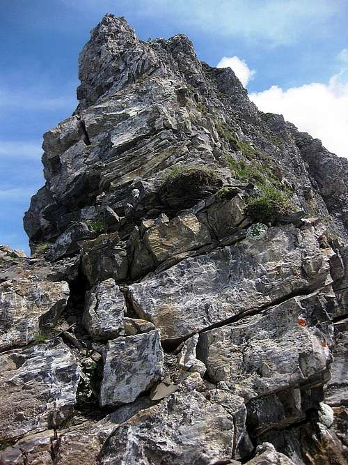
![The steep west ridge of Schwarzhorn]() Looking up that poor rock of the Schwarzhorn west rige
Looking up that poor rock of the Schwarzhorn west rigeExternal Links
Liechtenstein Alpine club
![The highest mountains of Liechtenstein]() On the morning of the fourth day, from the Pfälzerhütte, I could see what I was up against for the next few hours.
On the morning of the fourth day, from the Pfälzerhütte, I could see what I was up against for the next few hours.
Close by on the left are the steep cliffs on the northwest side of Naafkopf, which I had ascended yesterday - the summit (2570m) is further left.
The grey rock wall a bit further marks the southern border of Liechtenstein, with Switzerland. From left to right, the highest peaks are Schwarzhorn (2574m), Vorder Grauspitz (2599m) and Falknis (2560m), and finally, slightly lower, Falknishorn (2452m).
From this point of view, the best way to get up the Schwarzhorn is to descend a few hundred meters into the Naaftal (not visible, but directly ahead, just over the edge), then work your way up again to Ijesfürggli (2348m), the saddle between Naafkopf and Schwarzhorn. It's right behind the cliffs of Naafkopf. Schwarzhorn is easy from Ijesfürggli, but, as this photo already shows, getting down the other side is not!
Comments
No comments posted yet.