
|
|
Mountain/Rock |
|---|---|
|
|
37.89528°N / 79.8388°W |
|
|
Bath |
|
|
Hiking |
|
|
Spring, Summer, Fall, Winter |
|
|
3187 ft / 971 m |
|
|
Overview
As the mountains of Virginia go, Middle Mountain is...well...pretty much in the middle. It's not among the highest (generally considered to be those over 4,000 feet), but it's certainly not grouped with the low hills that precede the high country. It is a classic Blue Ridge peak which means that it's a long, steep-sided ridge or plateau separated from other summits by low gaps along the ridge line. It runs--as all of the Blue Ridge peaks do--southwest to northeast. Other nearby mountains lie to the east and west, cut off by steep valleys cut by various steams and small rivers.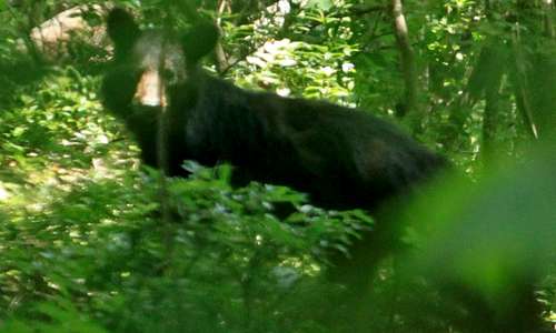
Black bear.
There are no open summits on Middle Mountain, but there are a few rocky breaks in the almost overwhelming cover of mainly hardwood forests. There are not many evergreens on the slopes, and what few grow there seem to be isolated in the wetter regions nearer the streams and springs. In late summer and autumn the water table retreats and many of those same springs and creeks all but vanish. The few waterfalls in the area vanish, too.
Middle Mountain is fortunately located in the midst of Douthat State Park, one of the finest such parks in Virginia. It was one of the state's original parks and the infrastructure is impressive, created mainly by the old Civilian Conservation Corps of the administration of Franklin Roosevelt.
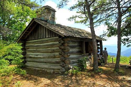
Cabin
One thing that impressed me about the area around Middle Mountain was the lack of roads. The main bulk of the ridge is a vast forested area sandwiched between a narrow county road and the main thoroughfare of the park access road. This makes for a lot of relatively untouched forest cover and excellent habitat for wildlife. In my long hike to the summit and back down I encountered two black bears. One saw me first and ran away at speed, and the other never noticed me at all (I kept my distance).
Middle Mountain and the park around it is classic old-style outdoor fun. There are amazing opportunities for hikes of all sorts, canoeing and kayaking (in the park lake), cycling, horseback riding, birding, wildlife viewing, jogging, etc. As far as state parks go, I found this park and this area to be one of the finest I've visited in the southeast.
(There are so many "Middle" Mountains in Virginia that I have marked this one by its location within Douthat State Park.)
Getting There
From Douthat State Park information:From Interstate 64 and Interstate 81 North of Lexington: Follow I-81 south to exit 56 and exit 191 onto I-64 west (signed, Clifton Forge). Follow I-64 west to exit 27, turn right onto Route 629. The park entrance is two miles farther; guest registration is another four miles. Register at the green-roofed building on the right. Drive time from Lexington is 35 minutes.
From Interstate 81 South of Roanoke: Follow I-81 north to exit 150B (signed, 220 North, Clifton Forge). Bear right onto U.S. 11 south, then turn right at first light onto U.S. 220 north. Follow U.S. 220 north. After passing through Iron Gate, take the first exit to the right (signed, Covington). Once on the three-lane road (Exxon on your right), continue under the interstate. This road becomes Route 629, which leads into the park. Its entrance is two miles farther; guest registration is another four miles. Register at the green-roofed building on the right.
Drive time from the intersection of I-81 and 220 north is 55 minutes.
From U.S. 460 East or West of Roanoke: Follow U.S. 460 to U.S. 220 alternate, turn north at light. Stay on U.S. 220 north through Iron Gate. After passing through Iron Gate, take the first exit to the right (signed, Covington). Once on the three-lane road (Exxon on your right), continue under the interstate. This road becomes Route 629, which leads into the park. Its entrance is two miles farther; guest registration is another four miles. Register at the green-roofed building on the right. Drive time from intersection of U.S. 460 and 220 Alternate intersection
is 65 minutes.
From U.S. 220 South of Roanoke: Follow U.S. 220 north to the Roy L. Webber Expressway. Follow the expressway to Interstate 581 north. Follow I-581 north to intersection I-81, exit right onto I-81 north. From here, follow I-81 north to exit 150B (signed, 220 North, Clifton Forge). Bear right onto U.S. 11 south, then turn right at first light onto U.S. 220 north. Follow U.S. 220 north . After passing through Iron Gate, take the first exit to the right (signed, Covington). Once on the three-lane road (Exxon on your right), continue under the interstate. This road becomes Route 629, which leads into the park. Its entrance is two miles farther; guest registration is another four miles. Register at the green-roofed building on the right.
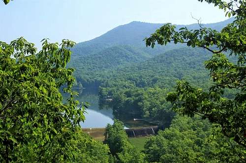
Lake
Middle Mountain is in Douthat State Park. All park rules apply.
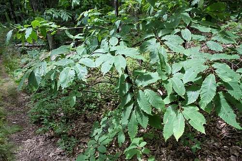
American chestnuts
Route
I used a series of interconnecting trails to reach the summit and make a long loop hike of 13 miles. I left the White Oak Campground and the Beard's Gap Hollow Trail to the Locust Gap Trail to the Blue Suck Falls Trail to the Middle Mountain Trail to the Tuscarora Overlook spur to the Stony Run Trail back to Locust Gap Trail/Beard's Gap Trail and return to White Oak Campground.(In late summer and early Fall, do not expect to see Blue Suck Falls except as a damp wall of rock.)
Red Tape
There is a park admission price of $3.00.Any camping done in the park must be in the official campgrounds.
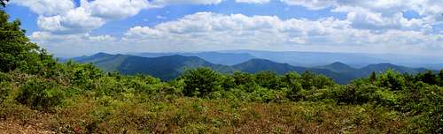
Tuscarora Overlook
When to Climb
All year.Camping
Use only the camping facilities in Douthat State Park. No backcountry camping.External Links
Douthat State Park.Trail Guide.