La montagna chiama i suoi figli, ed essi rispondono fedelmente al suo appello…
Osvaldo Cardellina, Diario alpinistico, 1964-65
Page texts: @ OsvaldoCardellina"Osva", passed away on May 2, 2022. Page owners: Christian Cardellina e Osvaldo Cardellina. Any updates from September 12, 2022: Antonio Giani, page administrator, friend and climbing companion.
Testi della pagina: @ OsvaldoCardellina "Osva", scomparso il 2 maggio 2022. Proprietari pagina:Christian Cardellina e Osvaldo Cardellina. Eventuali aggiornamenti dal 12 settembre 2022: Antonio Giani, amministratore della pagina, amico e compagno di salite.
Overview
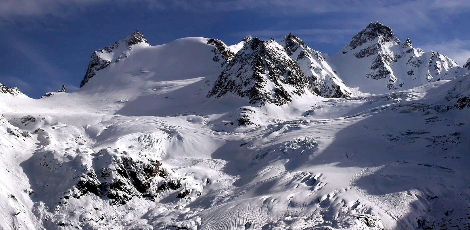
Apostles Chain from West-northwest (Valnontey), by Antonio
This crossing is part of the larger "Classic" of the Gran Paradiso. Very long ascent, is now reduced by the presence of the Money Bivouac at the foot of the Southwestern Slope of Punte Patrì, while in the past called for the departure or from Alessandro Martinotti Bivouac, at the foot of the Rock Viva, otherwise by the below homonym alp. The path in a day from Valnontey, if not directly from Cogne, was reserved for the few Mountaineers. It used for those with to hocks steel. Personally in July 1984 I was able to test the hypothesis intermediate and I would say is that I was more than enough, because the downhill in Valnontey is long and the fatigue accumulated into the distance is felt. On this occasion we made the first ascent of the West Couloir which at that time had not yet been addressed (see the Guide C.A.I./ T.C.I."Gran Paradiso" 1980, pages 428/9, where the route is plotted as 169ca without knowing ascents. Our climb however was held to be exact in the slope "open", and turned North-northwest, more right to theWwall Northwest, between this and the route 169ba). In this case the slope glacial increases from about 43°/45° to 55° abundant and requires good ice conditions and the absence of "verglass", even if the modern equipment allow to limit somewhat this "impasse". The climb ends on the North Ridge, turning on the face in the Eastern final stretch. The rock quality caution rather than actual difficulties. But this is only the starting point of the journey that then, addressing himself to the North, reaching the Summits of the two Towers of St. Andrea for finally concluded at that of Sant'Orso. This long ridge acts as a divider between the Valnontey (West) and the opposite of Valeille, dominating respectively Glaciers of Money between Grand St. Pietro and St. Orso Tower, content on the North by Cresta Paganini, and the Coupé de Money from this' and the last Punte Patrì, to below that Face Northwest normally used for the descent. On the opposite side, or Valeille exists the small glacier of the same name, which falls below the Colle di Teleccio and above the Bivouac Antoldi-Malvezzi, at the first sector; between the last two towers sits nestled the tiny Glaciers des Tours, now reduced to a miserable thing, which runs out on to the large slope moraine called "Croux du Grand Saint Pierre". The set of these three towers, of which a dual, is defined as a Group also Chain of the Apostles.
Apostles Chain from West-northwest (Valnontey), by Emilio Bertona aka emilius
Questa traversata rientra nelle grandi "Classiche" del Gruppo del Gran Paradiso. Ascensione piuttosto lunga, viene oggi ridimensionata dall'odierna presenza del Bivacco del Money alle pendici del versante Sudoccidentale delle Punte Patrì, mentre nei tempi passati richiedeva la partenza o dalla sottostante nonché omonima alpe oppure dal Bivacco Alessandro Martinotti ai piedi della Roccia Viva. Il percorso in giornata da Valnontey, se non addirittura direttamente da Cogne, era riservato a pochi Alpinisti. Quelli d'una volta dai garretti d'acciaio. Personalmente nel Luglio 1984 ho potuto provare l'ipotesi intermedia e direi che mi é stata più che sufficiente, anche perché la discesa a Valnontey é lunga e la fatica accumulata alla distanza si fà sentire. Nell'occasione abbiamo effettuato la prima ascensione del Couloir Ovest che a quei tempi non era stato ancora affrontato (vedi la Guida C.A.I./T.C.I."Gran Paradiso" del 1980, pagine 428/9, dove l'itinerario viene tracciato come 169ca senza però conoscere salite. La nostra salita comunque si é svolta per l'esattezza nel pendio "aperto", nonché rivolto a Nord-nordovest, più a destra verso la Parete Nordovest, tra questo e l'itinerario 169ba). In questo caso il pendio glaciale aumenta da circa 43°/45° a 55° abbondanti e richiede buone condizioni di ghiaccio ed assenza di "verglass", anche se le moderne attrezzature consentono di limitare alquanto quest'"impasse". La salita si conclude sulla Cresta Nord, girando sulla Parete Orientale nell'ultimo tratto. La qualità della roccia richiede prudenza più che per le effettive difficoltà della medesima. Ma questo risulta soltanto il punto iniziale della traversata che poi, indirizzandosi a Settentrione, raggiunge le due Sommità delle Torri di Sant'Andrea per infine concludersi con quella di Sant'Orso. Questa lunga cresta funge da divisorio tra la Valnontey (Ovest) e l'opposta della Valeille, dominando rispettivamente i Ghiacciai di Money tra Gran San Pietro e Torre di Sant'Orso, contenuto a Nord dalla Cresta Paganini, e del Coupé de Money tra quest'ultima e le Punte Patrì, al di sotto di quella Faccia Nordovest abitualmente utilizzata per la discesa. Sul versante opposto, o di Valeille esiste il piccolo Ghiacciaio omonimo, che scende al di sotto del Colle di Teleccio e sopra il Bivacco Antoldi-Malvezzi, in corrispondenza del primo settore; tra le due ultime torri si trova incastonato il minuscolo Glaciers des Tours, ormai ridotto a ben misera cosa, che si esaurisce sopra al grande pendio morenico chiamato "Croux du Grand Saint Pierre". L'insieme di queste tre torri, delle quali una duplice, viene definito come Gruppo o Catena degli Apostoli.
Descending on Valnontey Valley, by livioz
Why Apostles? Where does this name is somewhat controversial. Some say, the Summit appointed lower Twelve Apostles, the Great Saint Peter became such, being the highest ("Guide RAVA" 1930/32 and 1964, p. 290 by Mario Aldrovandi; others, like the Poet-Writer Giacomo Giacosa, that, following the discovery of ancient documents in Cogne, derives from the dialect "Peirro", also stone. The "Guide Gran Paradiso", 1939, 1963 and 1980 in pag. 422 accepts both hypotheses uniting; with a Renato Chabod, coauthor with Andreis and Sandri, which strangely is cautious in a field which is somewhat much informed. The same, however, suggest the crossing, smitizzandola a little compared to the assessments of the past and doing the same considerations as above; the proposal, however, is different from ours remaining along the watershed through the Ridges Southwest and the Southeast from Teleccio. The legendary B & V, that the people of Turin Giovanni Luigi Bobba and Vaccarone "glissando" (diverting) on the topic in the pages 76/79, where, however, it appears the unusual name of Pic du Coupé for Torre Sant'Orso appears while the "Pic du Retour" on the West Crest (Southwest) Great St Peter from the Hill of Money. Finally Umberto Pelazza in "Who knows why it is called so" on page 119 contests "a heavenly representation of the entire alpine kingdom" and also leads the Gran Paradiso as not to "Paradise of the Ibexes", wanted the Canon Frutaz, but simply the Italian version of "Grande Paroi or Granta Parey", or Great Wall. However admits, pages 127/8, the opinion of the illustrious Geologist Martino Baretti (1841-1905) that talks about that ten tips that keep company to the first Pope; by appealing to the Court of the Apostles mentions a famous intruder (Ursus), Patron of Cogne but also of Derby and Jovençan, and also to the Finger of the Apostles, he pointed at the Sky to the Coupé de Money. If he says Martin, who is the "older", he's right. "The seniority that makes able". For Pelazza, smelling of clerical also to Punte Patrì, former Pene Blanche, but here the "snag" has never been solved and continue to wander in the Mystery, hoping in the protection of the Holy Apostles ...
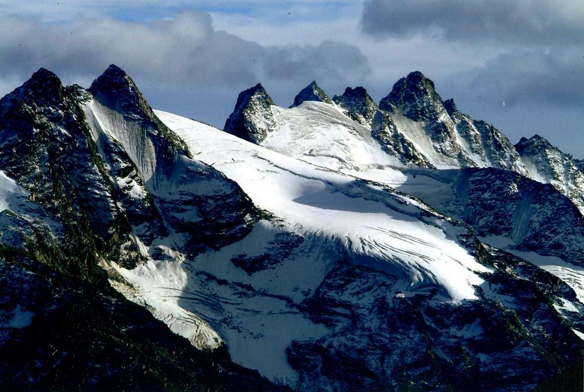
Gran San Pietro (right) towards Sant'Andrea & Sant'Orso up to the Pointes Patrì, by emilius
Perché Apostoli? Da cosa derivi questo toponimo risulta alquanto controverso. Qualcuno afferma che, nominate le Sommità inferiori Dodici Apostoli, il Gran San Pietro divenne tale, essendone il più elevato ("Guida R.A.V.A." 1930/32 e 1964, pag. 290 di Mario Aldrovandi; altri, come il Poeta-Scrittore Giacomo Giacosa, che, a seguito del ritrovamento d'antichi documenti in Cogne, derivi dal dialettale "Peirro", cioé pietra. La "Guida Gran Paradiso" 1939, 1963 e 1980, pag. 422 accetta entrambe le ipotesi unendole; con un Renato Chabod, coautore con Andreis e Sandri, che stranamente non si sbilancia in un campo nel quale é alquanto ferrato. Lo stesso consiglia però la traversata, smitizzandola un pò rispetto alle valutazioni del passato ed effettuando le medesime considerazioni di qui sopra; la sua proposta però é diversa dalla nostra rimanendo sempre in cresta tramite quella Sudovest o la Sudest dal Teleccio. I mitici B&V, ovvero i torinesi Giovanni Bobba e Luigi Vaccarone, "glissano" sull'argomento tra le pagine 76/79, dove però trovasi la denominazione inusuale di Pic du Coupé per la Torre di San Orso mentre appar il "Pic du Retour" sulla Cresta Ovest (Sudovest) del Gran San Pietro dal Colle di Money. Infine Umberto Pelazza in "Chissà perché si chiama così" a pagina 119 contesta "una rappresentazione tutta alpina del regno dei cieli" e riconduce anche il Gran Paradiso non come al "Paradiso degli Stambecchi", come voleva il Canonico Frutaz, bensì semplicemente alla versione italiana di "Grande Paroi o Granta Parey", ovvero Grande Parete. Però ammette, alle pagine 127/8, il parere dell'illustre Geologo Martino Baretti (1841-1905) che parla di quella decina di punte che tengono compagnia al primo Papa; appellandosi alla Corte degli Apostoli accenna ad un illustre intruso (Sant'Orso), Patrono di Cogne ma pure di Derby e Jovençan, ed anche al Dito degli Apostoli, puntato contro il Cielo al Coupé de Money. Se lo dice Martino, che é il "più vecchio", ha ragion lui. "Per anzianità che fà grado". Per Pelazza, odoran di clericale anche le Punte Patrì, ex Pene Blanche, ma qui il "busillis" non é mai stato risolto e continua a vagare nel Mistero, sperando nella protezione dei Santi Apostoli ...
San Pietro, Sant'Andrea & Orso three names for four Towers, complete traverse, by Ilario Antonio Garzotto
Getting There
BY CAR:
From TORINO, MILANO, etc: Motorway A5. Exit at IVREA or Quincinetto (PIEDMONT) also Pont Saint Martin, Verrès, Chatillon, AOSTA East (Nus) and West (Aymavilles) Municipalities (AOSTA Valley). From IVREA Town to Hone-Bard, Pont Bozet, Champorcher, Aymavilles, Villeneuve.
From Aymavilles towards Cogne Valley From Aymavilles(646m) towards Cogne Valley with Regional Main Road: Vieyes (1.132m) Fraction; continue to Silvenoire, Epinel and Crétaz Hamlets, Cogne(1.534m) Resort, through Main Road. To Valnontey(1.678m), through Municipal Road: to Money, Alessandro Martinotti, Stefano Borghi Bivouacs, through paths, moraines and glaciers. From Lillaz Fraction (1.607m) to Guido Antoldi & Laura Malvezzi Bivouac, by paths in Valeille Vallon, with traces in terminal parts. It is not necessary to take Motorway A5: you can drive on SS.26, in the direction of AOSTA - IVREA - TURIN.
BY PLANE:
Aeroporto "Corrado Gex" Saint Christophe (Aosta).
Approach & Routes Descriptions
Approach towards Money Bivouac
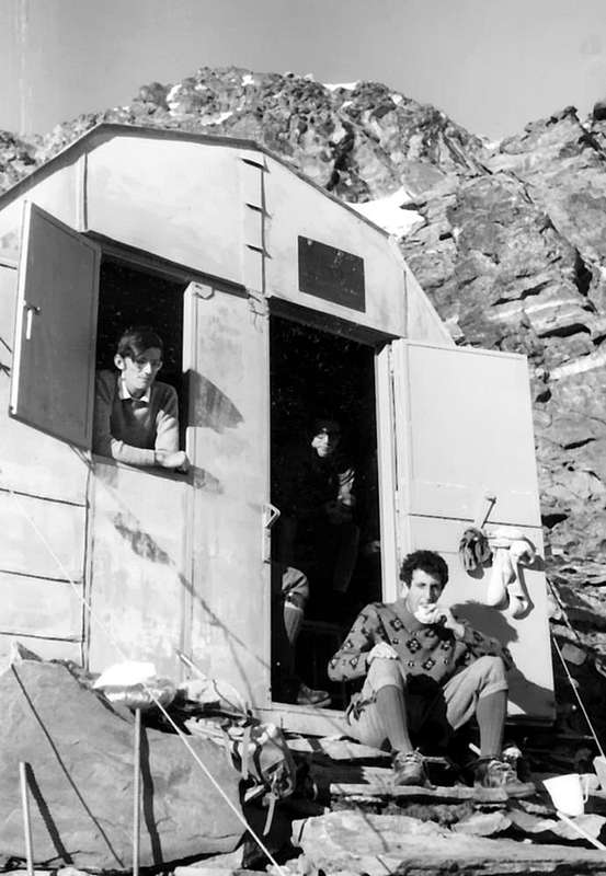
From Cogne (1.534m) along the Regional Road (public bus or by car) to Valnontey Hamlet (1.666m - wide car parking in soil). Along the Valnontey Vallon on its left side (East) through the trail n° 22/TVC and after the fine Valmiana Alpage (1.728m) follow the mule track till the fork (T/E; 0h'45) that, on the left and with path n° 22C/TVC, leads to the Money Houses. After (T/E; 2h'00/2h'20) walk you can see the Money and, little before getting there, keeping the left side, ascend along some morainic slopes and along the ridge of the lateral moraine (orographic right of the Coupè di Money Glacier. Along the same, which progressively increases in steepness, on small tracks, where it ends cross to the left a small valley of debris and broken rocks, up along a short but steep slope of rocks (anchors and chains) to get the well visible (yellow signs) Money Bivouac in color yellow ocher, while little above the bivouac (some anchors and chains) you can find the water coming out from the Southern Patrì Glacier. (2.872m; 1h'15/1h'30 from Money).
Money Bivouac July 1969, by Ilario Antonio Garzotto
Avvicinamento al Bivacco di Money
Dall'abitato di Cogne (1.534 m) in bus o in auto sino al Villaggetto di Valnontey (1.666 m) ove si parcheggia nell'ampio piazzale in terra battuta, salire la Valnontey tramite il sentiero n° 22/TVC sul versante della destra orografica e superato l'ameno Alpeggio di Valmiana (1.728 m) si prosegue per la mulattiera sino al bivio che sale verso sinistra con sentiero n° 22C/TVC per i Casolari del Money (E/T; 0h'45). Dopo circa 2h'00/2h'20 si notano i sopracitati casolari posti a quota 2.325 metri poco prima di raggiungerli sempre sulla sinistra superare alcuni pendii morenici risalire il dorso della morena laterale (destra orografica del Ghiacciaio di Coupé di Money). Salire la medesima sulla cresta su poco evidenti tracce di sentiero, alla fine della stessa, che progressivamente và aumentando in ripidezza, attraversare a sinistra un valloncello di sfasciumi e rocce rotte, superare il breve tratto di rocce abbastanza ripide (con l'ausilio di alcune catene fisse) precedenti di poco il Bivacco del Money (2.872 m; 1h'15/1h'30 dai Casolari del Money). Il bivacco è colorato in giallo ocra, mentre l'acqua, fuoruscente dal Ghiacciaio Meridionale di Patrì, si può trovare appena sopra il medesimo raggiungibile sempre con l'ausilio di catene fisse.
Crossing on the Apostles Chain
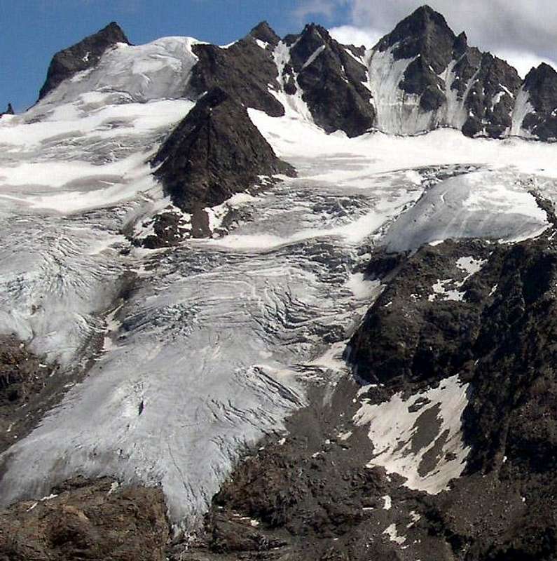
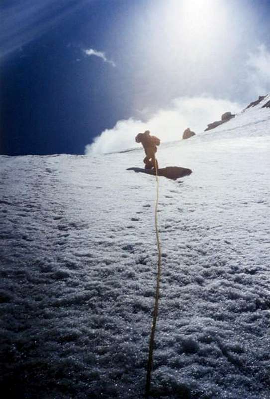
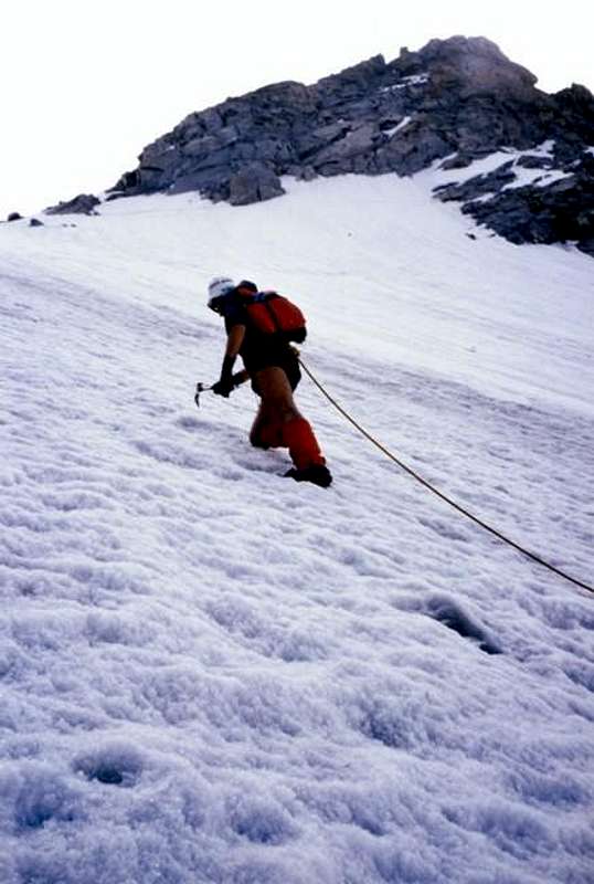
To Gran San Pietro(3.692m), highest amongst the Towers: from the Money Camp, toward the right side (orographic) of Coupè di Money Glacier, cross it crosswise to the base of the Cresta Paganini (3.440m), round it and follow along the Money Glacier (careful to the crevasses that may force to many bypassings) toward the icy slope between the Torre di Sant'Andrea and the Gran San Pietro Tower. Quite easily pass the terminal crevasse, generally closed and that in any case is passed smoothly, and start climbing the slide (220 meters arond). The slant is between 45° and 55°, bearing in mind that little by little that we move away from the central couloir to the right on the Face North-northwest the slope increases dramatically. Caution to the ending snowy corniche could be very thin, stay some metres below the same and reaching the San Pietro Pass in it highest part to the right (South; 3.558 m). Gradually climb over the Northern Crest of Great Saint Peter taking on its Eastern Slope, where a rocky couloir, easy but very steep and exposed leads to the Cross of the Summit. Also in integral on edge of the ridge a little most difficult (II°+/III°-; A/PD; 1h'00 from the saddle with the Tower of Sant'Andrea; 1h'50 from base). Made the descent with the same via, back to the small saddle, often reached by both sides to reach the Vertex, but never crossed it in one that in another sense. Now to the left for some metres to get the ridge leading to the Southern St. Andrea Tower (more precisely Southwest) through the easy Crest South-southwest with some deviation on both sides (3.640m); keeping the crest down to the small saddle and, descending through more than short Crest Northwest, and, bypassing an elevation to the Western side or Money (be very careful to the upper terminal crevasse that often can not be seen but there is subtly) through rocks rather steep but not too difficult, on again to the Northern Summit (better Northeast; 3.651m; A/PD-; 3h'30/4h'00 from bivouac). From the Northern Tower down through the North Ridge quite easy, through the watershed that after a small highlight (3/4 metres, II°-) become sharp and dangerous cornices in the Northeast (the conditions, for the same period in the year, were quite varied from the late sixties to the mid-eighties), to reach the Col de Saint André (3.574m) from which, after a subsequent harness or Paganini Col (3.555m), easily and quickly reach the St. Orso Tower through the brief Southwestern Crest before in snow up to the altitude 3.618 metres then by the easy and rotten rock in the form of blocks (A/PD-/PD; 2h'00/2h'30 by Gran San Pietro). The descent is via the Northwest Wall: first place to the left (West) towards the Cresta Paganini up to the quota 3610 metres, then dropped directly on Glacier Coupé de Money with a slope between 35° and 40°, without forced route but, generally by diagonal descent from left/right to reach the bergschrund or final crevasse on Glacier Coupé de Money to altitude 3.280/3.300 metres around. Through the same with more "high" route to Northwest it falls to Money Camp, or go down directly in Valnontey, making sure that the top of the moraine is quite steep and a few years ago registered is a fatal accident on the way back from the Punte Patrì (A/PD-; 1h'00; in total 6h'30/7h'30).
On West-northwestern Face July 1984, by Maurizio Castellan
Traversata degli Apostoli
Al Gran San Pietro (3.692 m), il più elevato delle Torri: dirigersi a Sudest in direzione della destra orografica del Ghiacciaio del Coupé di Money e, attraversandolo diagonalmente verso la base terminale della Cresta Paganini (3.440 m), aggirare la stessa; da qui procedere decisamente sul Ghiacciaio del Money, facendo attenzione ai numerosi crepacci che a volte costringono a fastidiosi aggiramenti, verso lo scivolo ghiacciato tra la Torre di Sant'Andrea e la Torre del Gran San Pietro. Con precauzione superare la terminale, in genere chiusa nonché agevole da passare, e iniziare la salita dello scivolo (circa 220 m) con pendenze varianti tra i 45° ed i 55°, tenendo presente che a poco a poco che ci si allontana dal couloir centrale e verso destra sulla Faccia Nord-nordovest la pendenza aumenta notevolmente. Fare attenzione al cornicione finale che potrebbe essere molto sottile, restando qualche metro al disotto del medesimo e raggiungendo il Colle di San Pietro nella sua parte più elevata verso Mezzogiorno (3.558 m). Progressivamente scavalcare la Cresta Settentrionale del Gran san Pietro portandosi sul suo Versante Orientale, dove un canale roccioso, facile ma ripido e molto esposto conduce alla Croce della Cima, oppure sul filo di cresta con percorso un pò più difficile ed esposto su entrambi i lati (possibilità di incontrare "verglass", II°+/III°-; A/PD; 1h'00 dalla selletta; 1h'50 dalla base). Effettuata la discesa, con la stessa via, rientrare alla selletta, spesso raggiunta da ambo i lati (i primi salitori E. Carr e A.F. Mummery da Est, il 2 Agosto 1891) per raggiungere la Vetta, ma mai attraversata sia nell'uno che nell'altro senso. Da qui portarsi verso sinistra per alcuni metri ed iniziare su cresta la salita alla Torre Sant'Andrea Meridionale (meglio Sudovest) tramite la facile Cresta Sud-sudovest con qualche deviazione su entrambi i lati (3.640 m); sempre sulla cresta ridiscendere per mezzo della più che breve Cresta Nordovest, e, aggirando un'elevazione ad Ovest sul versante Money (fare molto attenzione alla terminale superiore che spesso non si vede ma subdolamente esiste e scende ancor più pericolosamente sinuosa contro le rocce) tramite rocce piuttosto ripide ma non troppo difficili, salire alla Torre Settentrionale (o Nordest; 3.651 m); A/PD-; 3h'30/4h'00 dal Bivacco di Money). Dalla Torre Settentrionale scendere con l'abbastanza facile Cresta Nord, tramite lo spartiacque che dopo un piccolo risalto (3/4 metri, II°-) diventa affilato e con pericolose cornici a Nordest (le condizioni, a parità di periodo nell'anno, erano alquanto variate dalla fine degli anni sessanta a metà degli ottanta) raggiungendo il Col de Saint André 3.574 m dal quale, dopo una successiva selletta o Col Paganini (3.555m), facilmente ed in breve tempo si raggiunge la Torre di Sant'Orso dapprima con una crestina nevosa sino alla quota 3.618 metri e poi per mezzo di facili rocce a blocchi (A/PD-/PD; 2h'00/2h'30 dal Gran San Pietro). La discesa avviene tramite la ghiacciata Parete Nordovest; subito appoggiare a sinistra (Ovest) verso la Cresta Paganini sino alla quota 3.610 metri, poi scendere direttamente sul Glacier Coupé de Money tramite un pendio tra i 35° e 40° senza percorso obbligato ma, generalmente con diagonale in discesa da sinistra verso destra onde raggiungere la crepaccia terminale sul Glacier Coupé de Money a quota 3.280/3.300 metri circa. Attraversato il medesimo "alti" verso Nordovest si rientra al bivacco, oppure si scende direttamente in Valnontey, facendo attenzione che la parte superiore della morena é alquanto ripida e qualche anno orsono s'é registrato un incidente mortale al ritorno dalle Punte Patrì (A/PD-; 1h'00; complessivamente 6h'30/7h'30).
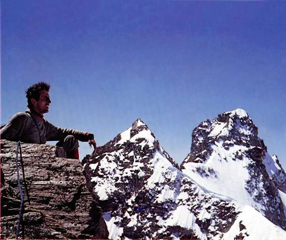
Sant'Orso Tower Summit 1969, by Ilario Antonio Garzotto
Difficulties & Equipment
Difficulties
This route can be considered from PD- up to the AD- (depending on mountain and ice conditions).
L'itinerario è classificato da PD- sino a AD- (dipende dalle condizioni della montagna). Equipment
For Mountaineering with rope, ice-axe and crampons.
Da Alpinismo con corda, piccozza e ramponi.
Mountain Condition
Meteo: you can find all the needed informations at the official site of the Valle d'Aosta Region:
"Guida delle Alpi Occidentali" di Giovanni Bobba e Luigi Vaccarone C.A.I. Sezione di Torino Volume II° (parte II) 25-05-1896.
"Guida dei Monti d'Italia-Gran Paradiso Parco Nazionale" E. Andreis, R. Chabod, M. C. Santis, Club Alpino Italiano/Touring Club Italiano, prima Ed. 1939; seconda Ed. 1963; terza Ed. 1980.
"Rifugi e bivacchi in Valle d'Aosta" di Cosimo Zappelli aggiornata da Pietro Giglio. Musumeci Editore, Luglio 2002.
"Il Parco Nazionale del Gran Paradiso (Valli di Champorcher-Clavalitè-Saint Marcel-Laures-Cogne-Valsavarenche-Conca di Pila" di Giulio Berutto 3/volume 2°, IGC, Torino 1981, 2a Ed. 2000.
"Gran Paradiso - Itinerari Alpinistici e sci Alpinistici" di Franco Brevini Ed. Musumeci, Giugno 1982.
"Diari Alpinistici" di Osvaldo Cardellina e Indice Generale accompagnato da Schedario Relazioni Ascensioni 1964-2019 (inediti).
Kompass - "Gran Paradiso Valle d'Aosta Sentieri e Rifugi" Carta Turistica 1:50000.
Enrico Editore Ivrea-Aosta – "Gruppo del Gran Paradiso" 1:50000.
I.G.C. Istituto Geografico Centrale Torino "Gran Paradiso-La Grivola-Cogne" 1:25.000.
A.I.A.T. "Cogne Gran Paradiso Aymavilles - Walking Map" 1:25.000.
I.G.C. Istituto Geografico Centrale Torino "Il Parco Nazionale del Gran Paradiso" (3) 1:50.000.
L'Escursionista "Valle di Cogne Carta dei Sentieri" (n° 10) 1:25.000.
L'Escursionista "Tour de la Vallée de Cogne Grand Paradis" Carta dei sentieri 1:25.000.


 3509 Hits
 82.48% Score
 15 Votes