. A tradition that, as said livioz of Genoa (
), is already leaked from the entry into Valgrisa: "In memory of Pope Paulus Johannes II°, in the day of his obsequies I want to post a photo of the church of Les Combes, the small village in Valle d'Aosta where he often spent his summer vacations. He used to hike along the trails running along the watershed Val di Rhêmes-Valgrisenche." An entry
in every sense, dominating the sky that runs deeper in the valley going up from the Village of Leverogne (always by Arvier up to the Village of Planaval). Including what remains of the
at the villages of Petit and Grand-Haury, as if to underline the domination heavenly than earthly. Pope Karol Józef Wojtyla, namesake of his father, that is Karol Wojtyla (1879-1941) and 264º Pope of the Roman Catholic Church that from Wadowice in Poland (* May 18, 1920) has come down here in the small Valley of Aosta, in the little Town Arvier to retire in prayer in the tiny Les Combes. Admiring the chain of Mont Blanc. So for summers until his death at 84 years in Vatican City (+ 2 April 2005). Then from the great St. Peter's Basilica at the small and little-known Valgrisenche. At the foot of the Becca del Merlo or Chamin. Following the cause of beatification on 1 May 2011 was beatified by his immediate successor Benedetto XVI° or Pope Ratzinger with an event unusual in the history of the Catholic Church, and in the case for a Millennium that a pope proclaimed Blessed their immediate predecessor. April 27, 2014 was proclaimed a Saint by Pope Francis with Giovanni Roncalli or Pope giovanni XXIII°. Moreover Józef Wojtyla is what first non-Italian pope for 455 years, or since Adriano VI° (* 1522 + 1523), was also the first Polish Pope in history and the first from a country of Slavic language. His pontificate lasted 26 years, 5 months and 17 days and was the third longest pontificate in history (after that of Pius IX° and that traditionally attributed to the Apostle Pietro). But above all, for those of Arvier and higher up, a Pope who loved their valley and its people and on the trail of which it is moved even the German Ratzinger continuing the tradition of summer holidays in Valgrisa. A great symbol that has marked this valley in which the signs of the
abound everywhere until Mondanges under the artificial lake or Beauregard Dam, now in an advanced stage of decommissioning because of its danger, and proceed beyond the small villages of Bonne, Menthieu , Surier and Usellières, ie above and at the end of it.
Ma pur un viaggio verso la "Cristianità". Una tradizione che, come afferma livioz di Genova (vedi la prima foto in Overview), trapela già dall'ingresso in Valgrisa: "In memoria di Papa Giovanni Paolo II°, nella giornata delle sue esequie io vado a postare una foto della Chiesetta di Les Combes, il villagetto della Valle d'Aosta ove lui sovente amava trascorrere le sue vacanze estive. Aveva l'abitudine di fare escursioni lungo i sentieri che corrono lungo lo spartiacque della Val di Rhêmes-Valgrisenche." Un'entrata "alta" in tutti i sensi, che domina dal cielo quella scorrente più profonda sul fondovalle salendo dal Villaggio di Leverogne (sempre in Comune d'Arvier fino alla Frazione di Planaval). Compreso ciò che rimane della Torre e Castello di Montmayeur presso i Villaggi del Petit e del Grand-Haury, quasi a voler sottolineare il dominio celeste rispetto a quello terreno. Un Papa Karol Józef Wojtyła, omonimo del proprio padre, cioé Karol Wojtyła (* 1879 * 1941) nonché 264º Papa della Chiesa Cattolica Romana che da Wadowice in Polonia (* 18 Maggio 1920) é giunto sin qui nella piccola Valle d'Aosta, nel piccolo Comune d'Arvier per ritirarsi in preghiera nel minuscolo Les Combes. Ammirando la Catena del Monte Bianco. Così per estati fino alla sua morte ad 84 anni in Città del Vaticano (+ 2 di Aprile del 2005). Quindi dalla grande Basilica di San Pietro alla semisconosciuta Valgrisenche. Ai piedi della Becca del Merlo o di Chamin. In seguito alla causa di beatificazione, il 1º maggio 2011 è stato proclamato Beato dal suo immediato successore Benedetto XVI° o Papa Ratzinger con un avvenimento che nella storia della Chiesa Cattolica, non avveniva da un Millennio, ovvero che un papa proclamasse beato il proprio immediato predecessore. Il 27 Aprile 2014 è stato proclamato Santo da Papa Francesco insieme a Giovanni Roncalli o Giovanni XXIII°. Inoltre Józef Wojtyła risulta quale primo papa non italiano dopo 455 anni, cioè dai tempi di Adriano VI° (* 1522 + 1523), ed è stato anche il primo pontefice polacco nella storia nonché il primo proveniente da paese di lingua slava. Il suo pontificato è durato 26 anni, 5 mesi e 17 giorni ed è stato il terzo pontificato più lungo della storia (dopo quello di Pio IX° e quello tradizionalmente attribuito a Pietro Apostolo). Ma soprattutto, per quelli d'Arvier e più in sù, un Papa che ha amato la loro valle e la sua gente e sulle tracce del quale s'é mosso anche il tedesco Ratzinger continuando la tradizione delle vacanze estive nella Valgrisa. Un gran simbolo marchiante la vallata nella quale i segni di "Cristianità" abbondano ovunque sino a Mondanges, sotto la Diga di Beauregard, ora in fase d'avanzato smantellamento a causa della sua pericolosità, e proseguon oltre nei Villaggetti di Bonne, Menthieu, Surier ed Usellières, cioé sopra ed al termine della medesima. Un lungo viaggio che quasi non ha confini e che solo s'infrange contro i ghiacciai e le pareti della maestosa Grande Sassière.
Specific Itineraries Roads and some small Hike
Two are the possibilities towards the Valgrisenche:
1)- whether arriving from West to East that (Aosta State Road n. 26 to 15 km) to reach the Hamlet of Leverogne
(740m), nearby Arvier Municipality, and with winding road, going up the steep rocky hill above dominated by the
Church of Rochefort currently being restored, to reach in succession the small Villages of Garin
(796m), Ra(e)voire (
950 metres; San Pietro in Vincoli Chapel; gym rock) and, with beautiful views to the ruins of the grim
Castle Montmajeur or Montmayeur sited on hanging rocky promontory, to reach Villages of Chamençon
(1278m) and Chamin
(1278m), both are left to the East. The next Fraction of Planaval (
1557 metres; Church and "Maison-forte" of XIII° Century), mouth of the vallon, is discarded right and continue to the South to the Villages of Revers
(1615 metres; yellowish Chapel of 1902 with mini Steeple).
"Sentier d'antan" (of yesteryear) and trip to the Alpage of Bòregne (2000 metres)Wanting instead to walk, from Revers, starting in the village and just before the Church (signaling paths in yellow) you can make two different solutions:
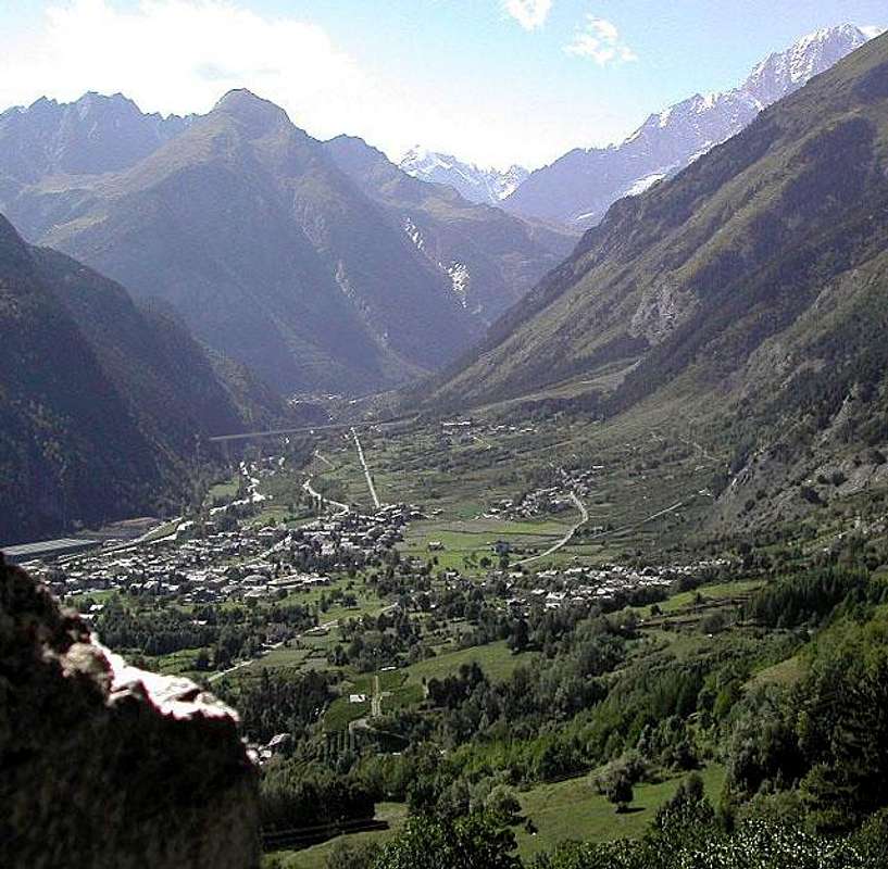
a)- to reach the Chief-town of Valgrisenche and the next little Village of Mondanges through trail
n° 22, which goes up with a long diagonal to the East of the Doire de Valgrisenche, reaching in succession the little localities of Prariond
(1548/58m), La Frassy
(1658/76m), Planté
(1656m), Gerbelle
(1621/29m) and then passing on the other side of the Valgrisenche's Doire, the Capital of Valgrisenche and the small Village of Mondanges just across the Beauregard Dam, currently in an advanced stage of dismantling (the last part is closed at this time for the work in progress;
1660 metres; average with routes from
0h'35 to 1h'30, taking as reference for
1h'00 Hamlet La Frassy.
b)- or by Revers up with path
n° 4B decidedly Eastwards reaching Alp Bòregne
(2000m);
1h'15/1h'30), located at the foot Grand Revers, Becca Verconey
(3165m, 2925m).
Continuing instead on the Regional Road, always with short detour to the East, you will reach the Villages of Prariond
(1548 metres; Chapel with tiny belfry, built aigainst the houses and with
windows ogival), Céré (
1605 metres; Chapel with a fresco in front) and La Bethaz (
1655 metri; brief excursion towards the Alp Miollet, 1895 metres, with small path
n° 18;
0h'45/1h'00) to finally reach the Chief-lieu of Valgrisenche
(1661m) and the nearby of Mondanges (
1652 metres; yellowish Chapel with tiny bell).
Returning from Bonne Village (Valgrisenche Municipality) towards Planaval Fraction (Arvier) in the mid valley, by Osw 20152)- Or, as already proposed in
"One-week trip around Castles Churches and Shrines: North Valley High (Valdigne) / R-1", from Villeneuve Common to take the Regional Road to Introd Commune but not reach the same why you visited already since the second day. Instead reached the junction
806 metres for
Villes Dessous small Hamlet at the
Chapel of St. Giacomo of 1867 cross the country reaching
Ville Dessus with little
Church of St. Hilary always 1800. Here
(863m) can also be reached by continuing briefly on Regional Road and with short descent that leads to the tiny square in front of the same, where as part of a much shorter nice walk on an
ancient paved and signaled path and adressed to the immediately above little
Chapel of Santa Anna (0h'15) on the road that goes down to Arvier Municipality. From this, with mini
"Picnic area" and small car park as well as magnificent views over the Central Valley of Baltea and the Group of Mount Emilius
(3559m), continue straight on the right, leaving the detour to
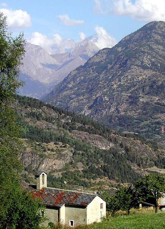
Les Combes Village, just below the Mont de l'Âne and Becca del Merlo or of Chamin, (
1341m; San Lorenzo Chapel), the place of spiritual summer retreats of the Popes
"John Paul II° Benedict XVI°" in recent years, always passing high above the
"Comba Neye de la Mort". From Les Combes descend, always with paved road to the Village of Grand Haury (
1178m; Chapel of St. Mary Magdalene; small hike through the forest and to the Northwest via small path
n° 2A to the remains of the
Château de Montmayeur 1149 metres) and Petit Haury (
1050m; Chapel of Santa Margherita), Verney
894 metres; Chapel of St. Leonard), Crête
821 metres; Chapel of St. Rocco and Anna) and hence to Avier Leverogne junction in the previous way. So doing stretches a little the way, but definitely making the most beautiful, charming and attractive.
From Arvier towards Valgrisenche with Beauregard Dam even passing through Les Combes Village, by Antonio, livioz & CorvusDue sono le possibilità per recarsi in Valgrisenche:
1)- sia arrivando da Ovest che da Est (Aosta Strada Statale n. 26 a 15 Km) raggiungere il Borgo di Leverogne
(740 m), presso il Comune di Arvier, e con stretti tornanti, risalendo la ripida collina rocciosa soprastante dominata dalla
Chiesa di Rochefort attualmente in fase di restauro, raggiungere in successione i Villaggetti di Garin
(796 m), Ra(e)voire (
950 metri; Cappella di San Pietro in Vincoli; palestra di roccia) e, con bella vista sui resti dell'arcigno
Castello di Montmajeur o Montmayeur sospeso sul soprastante promontorio roccioso, raggiungere quelli di Chamençon
(1278 m) e Chamin
(1278 m), che entrambi vengono lasciati ad Est. La successiva Frazione di Planaval (
1557 metri; Chiesa e Casaforte del XIII° Secolo), all'imbocco dell'omonimo vallone, si scarta a destra continuando a Mezzogiorno verso il Villaggetto di Revers (
1530 metri; Cappella giallognola del 1902 con campaniletto), collocato alle pendici Settentrionali di Grand Revers, Becca di Tos e Becca Verconey
(3164/5 m, 3301 m, 2925 m).
"Sentier d'antan" e gita all'Alpeggio di Bòregne (2000 metri)Volendo invece camminare, da Revers, partendo dentro il villaggio e subito prima della Chiesa (segnalazione dei sentieri in giallo) si possono effettuare due soluzioni diverse:
a)- raggiungere il Capoluogo di Valgrisenche ed il successivo villaggetto di Mondanges tramite il sentiero
n° 22, che sale con un lungo diagonale ad Oriente della Doire de Valgrisenche, raggiungendo in successione le località di Prariond
(1548/58 m), La Frassy
(1658/76 m), Planté
(1656 m), Gerbelle
(1621/29 m) e poi, transitando sulla sponda opposta della Doire, il Capoluogo di Valgrisenche ed il Villaggetto di Mondanges proprio di fronte alla Diga di Beauregard, attualmente in fase avanzata di smantellamento (lo ultimo tratto risulta in questo momento chiuso per i lavori in corso;
1660 m; mediamente con percorsi da
0h'35 ad 1h'30, tenendo come riferimento
1h'00 per La Frassy.
b)- oppure da Revers salire col sentiero
n° 4B decisamente ad Est raggiungendo l'Alpe di Bòregne (
2000 m);
1h'15/1h'30), posta alle pendici della Becca Verconey
(2925 m).
Continuando invece sulla Regionale, sempre con breve deviazione ad Oriente, si raggiungono i Villaggi di Prariond (
1548 metri; Cappella con Campaniletto, costruita in corpo alle abitazioni e con
finestre ad ogiva), Céré (
(1605 metri; Cappellina con affresco frontale) e La Bethaz (
1655 metri; breve escursione all'Alpe Miollet, 1895 metri, con sentierino
n° 18;
0h'45/1h'00) pervenendo infine al Capoluogo di Valgrisenche
(1661 m) e la vicina Frazione di Mondanges (
1652 metri, Cappella giallina con campanella).
A little tour from Valgrisenche towards Bonne and Menthieu Villages in the upper valley with Beauregard Dam, by Osw 20152)- Oppure, come già proposto in
"One-week trip around Castles Churches and Shrines: High North Valley (Valdigne) / D-1", dal Comune di Villeneuve prendete la strada per
Introd ma non lo raggiungete poiché lo avete visitato di già nella seconda giornata. Raggiunto invece il bivio
806 metri per
Villes Dessous presso la
Cappella di San Giacomo del 1867 attraversate il paese raggiungendo
Ville Dessus con Chiesetta di Sant'Ilario sempre del 1800. Qui
(863 m) si può giungere anche continuando per breve tempo sulla Strada Regionale e con breve discesa che porta alla piazzetta davanti alla medesima, dove parte una tanto corta quanto bella passeggiata su d'un
antico sentierucolo lastricato nonché segnalato verso la soprastante
Cappelletta di Santa Anna (0h'15) sulla Strada che scende ad Arvier. Da questa, con mini parcheggio e minuscola
"Area Picnic" nonché magnifico panorama sulla Valle Centrale della Dora Baltea ed il Gruppo del Monte Emilius
(3559 m), si prosegue, lasciando la stada che scende ad Arvier, si prende subito sulla sinistra (Ovest) la deviazione per
Les Combes (
1341 m; Cappella di San Lorenzo), luogo dei ritiri estivi spirituali dei Papi
"Giovanni Paolo II° e Benedetto XVI°" negli ultimi anni, sempre passando alti sopra la
"Comba Neye de la Mort". Da Les Combes si scende, sempre con strada asfaltata, ai Villaggi di Grand Haury (
1178 m; Cappella di Santa Maddalena; piccola escursione attraverso la foresta e verso Nordovest tramite il sentiero
n° 2A ai resti del
Château de Montmayeur 1149 metri) e di Petit Haury (
1050 metri; Cappella di Santa Margherita), Verney
894 metri; Cappella di San Leonardo), Crête
821 metri; Cappella dei Santi Rocco ed Anna) donde ad Avier e Leverogne allacciandosi alla precedente via. Così facendo si allunga di un poco il percorso, rendendolo però sicuramente più bello, suggestivo ed attraente.
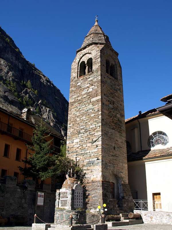
![]() Valgrisenche main Church of XII° Century rebuilt in 1873 with Steeple of XIV°,
Valgrisenche main Church of XII° Century rebuilt in 1873 with Steeple of XIV°,
by Osw 2015
Finally towards La Thuile Valley and Little Saint Bernard Pass
Towards the La Thuile Valley with the Hill of "Piccolo San Bernardo"
Specific Itineraries Roads and some small Hike
Two are the possibilities even towards the La Thuile Valley:
1)- To round off our week-long trip or would like to visit more carefully places, we have a few more days in the afternoon, after visiting the "Valgrisa" Valley in a morning, concluding with that of La Thuile. Maybe going to the Little Saint Bernard Pass (2188m) on the border with La Rosiere-Resort (1942m) in Tarentaise Valley, now in French soil. To do that we have available, as for Valgrisenche, two solutions that this time, however, present a more logical connection through the top, or through the Colle San Carlo (1971m), located between the Municipalities of Morgex and La Thuile and leaving more to the West to Pré St. Didier between the Tête Arpy (2017m) to the East and the Mont Crammont (2736m) on the opposite side. A choice, as we will see in the next step, which can also be done with reverse path, or from Pré Saint Didier in Morgex adjacent Communes. Leaving the National Road No. 26 at the roundabout before the entrance in the center of the Municipality of Morgex you pass the Dora Baltea to the deck just South of that meeting almost immediately, as well as the signs in brown for the Colle San Carlo, the tiny Chapel of St. Rocco between the small Villages Liarey and Pautex reaching then the Pre Villair (929m), Biolley (under the "Gym Rock"), Tirecagne, Kiriaz, Jaccod localities and the important Hamlet of Arpy to the entrance in vallon of the same name (1680m; Chapel "Notre Dame des Neiges"). From here take the Regional Road with a long diagonal to the Southwest below the Eastern slopes of Tête of Arpy reach Colle San Carlo (1971m, immediately above the Hôtel "La Genzianella"). From this point there are two short hikes or, rather, with walks leading easy but highly scenic routes to:
c)- with concomitant unnumbered trail to the private road to the North-northeast towards the famous "Belvedere" (great views of Mont Blanc and Grandes Jorasses up the Aiguille de Leschaux in Northwest and North and on entire Central Valley of the Dora towards Châtillon Common) and to just above Cross of Tête Arpy (0h'40 round trip).
d)- As to the Southeast through the forest path n° 15, always concomitant to another dirt towards Lake Arpy (2063m), located at the Western foot of Becca Pouegnenta (2675m) as well as those in North of Northern Summit Mont Colmet (3020m), with great views, on the way, on Giant's Tooth to Jorasses (2h'00/ 2h'15 ascent and descent).
Now you have to get off the San Carlo Hill with the Regional Road that, through the "Trenches Prince Thomas" in Petosan location and Théraz, Granges (1838m), Preylion (1552m), Bouic (1524m), Thovex-Moulin small Hamlets, without meeting Churches or Castles but with great views on the Mont Blanc Pylons comfortably port in La Thuile.
2)- But we can also get here by continuing on Highway No. 26 which continues from Morgex to the next Municipality of Pré Saint Didier, where a Regional Road, cross the bridge at the "Spa Station of Thermal Waters" (great views of the Southeast slope of Mont Blanc), with steep switchbacks than "furiously" overcome the famous and renowned "Ravine Pré St. Didier" to climb then to a series of anti-avalanche galleries until you reach the Village Elévaz (1322m; Chapel "Notre Dame de la Visitation") and the subsequent , into a fearsome gorgia, of La Balme (1309m; Chapel of Sainte Marie Madeleine; two fountains of 1912). Through immediately below the bridge on the Doire de La Thuile the road, passing the village of Revers (1338m), an abandoned Barracks and the Cross of Ste Barbe, reaches La Thuile at the Chapel of St. Nicolas (1447m).
Anche due sono le possibilità per recarsi Valle di La Thuile:
1)- Infine per concludere il nostro viaggio d'una settimana o, volendo visitare più attentamente i luoghi, qualche giorno in più dobbiamo nel pomeriggio, dopo avere visitato la Valgrisa in mattinata, concludere con quella di La Thuile. Andando magari fino al Colle del Piccolo San Bernardo (2188 m) al confine con La Rosière (1942 m) in Tarentaise, ormai in suolo francese. Per ciò fare abbiamo a disposizione, come per la Valgrisa, due soluzioni offerenti però questa volta un collegamento più logico passando in alto, ovvero tramite il Colle San Carlo (1971 m), posto tra i Comuni di Morgex e La Thuile e lasciando più ad Occidente quello di Pré Saint Didier sotto la Tête d'Arpy (2017 m) ad Est ed il Mont Crammont (2736 m) sull'opposto versante. Scelta, come vedremo al punto successivo, che può essere anche effettuata con percorso inverso, cioé da Pré St. Didier a Morgex.
Lasciando la Strada Statale n° 26 presso la rotonda che precede lo ingresso nel centro del Comune di Morgex si passa la Dora Baltea sul ponte subito a Sud del medesimo incontrando quasi subito, oltre che le indicazioni in colore marrone per il Colle San Carlo, la Cappelletta di San Rocco tra i piccoli Villaggi di Liarey e Pautex raggiungendo poi quelli di Pre Villair (929 m), Biolley (sotto la "Palestra di Roccia"), Tirecagne, Kiriaz, Jaccod e lo importante Villaggio di Arpy allo ingresso dello omonimo vallone (1680 m; Cappella "Notre Dame des Neiges". Da qui la Regionale con un lungo diagonale verso Sudovest alle pendici Orientali della Testa d'Arpy raggiunge il Col San Carlo (1971 m; "Hôtel La Genzianella"). Da questo punto sono possibili due brevi escursioni o, per meglio dire, passeggiate conducenti con facili percorsi ma altamente panoramici verso:
c)- con sentiero non numerato concomitante alla poderale verso Nord-nordest al famoso "Belvedere" (grandiose vedute sul Monte Bianco e sulle Grandes Jorasses fino all'Aig. de Leschaux a Nordovest e Nord e sull'intera Valle Centrale della Dora fino a Châtillon) ed alla appena soprastante Croce della Tête di Arpy (0h'40 tra andata e ritorno).
d)- Mentre verso Sudest (appena dietro la fontanella in legno presso i pannelli di segnalazione) parte attraverso la fitta foresta il sentiero n° 15, sempre concomitante ad un'altra poderale in direzione del Lago di Arpy (2063 m), posto alle pendici Occidentali della Becca Pouegnenta (2675 m) nonché a quelle Settentrionali della Punta Nord del Mont Colmet (3020 m), con vedute grandiose, durante il tragitto, dal Dente del Gigante alle Grandes Jorasses (2h'00/2h'15 tra salita e discesa, delle quali 1h'20 all'andata).
Non rimane che scendere dal Colle San Carlo con la Regionale che, passando attraverso le "Trincee del Principe Tommaso" a Petosan ed i Villaggi di Théraz, Granges (1838 m), Preylion (1552 m), Bouic (1524 m), Thovex-Moulin, senza incontrar Chiese o Castelli ma con grandi vedute sui Piloni del Monte Bianco comodamente porta a La Thuile.
2)- Ma possiamo qui arrivare anche continuando sulla Statale n° 26 che da Morgex prosegue verso il successivo Comune di Pré Saint Didier, dove una Regionale, oltrepassato il ponte presso la "Stazione Termale" (grandi vedute sul Versante Sudest del Monte Bianco), con ripidi tornanti supera "furiosamente" il famoso "Orrido di Pré St. Didier" per inerpicarsi poi decisamente verso una serie di gallerie anti-valanga insino a raggiungere il Villaggio di Elévaz (1322 m; Cappella "Notre Dame de la Visitation") ed il successivo, dentro una temibile gorgia, di La Balme (1309 m; Cappella di Sainte Marie Madeleine, due fontane del 1912). Attraversato subito appresso il ponte sulla Doire de La Thuile la strada, passando per il Villaggio di Revers (1338 m), una Caserma abbandonata e la Croce di Ste-Barbe, raggiunge la Thuile presso la Cappella di St. Nicolas (1447 m).
Navigating La Thuile and going upward to "Piccolo, perhaps with the Consular Road"
Now we have to visit La Thuile and then proceed to the "little". If we come from the Colle San Carlo, after we meet, leaving to left the Santa Anna Chapel at the Moulin, the Chapel of San Rocco, where a plaque on the wall of the front side recalls that was built in 1630 for praying the Holy to expel the scourge of plague. It was restored in 2007 dall'A.N.A. or National Alpine Troops Association. Just below a small parking lot before the Parish Church of St. Nicholas. A long history, which began in the year 800 with the same dedicated to the cult of San Defendente, Patron Saint of the terrible danger of avalanches that upset the whole valley. Destroyed, it was rebuilt in 1732 but his life turned short because in 1794 the French troops, which already foreshadowed the arrival of Napoleon Bonaparte in 1800 (though it passed with a surprise through the "Great"), have burned. It was rebuilt in part dedicated to Saint Nicholas, Holy beloved by Saint Bernard of Menthon later founder of the two Hospices, ignoring that the real Patron Saint of La Thuile was in ancient times St. Bartholomew. Perhaps for this reason it was never lucky and signs of ancient edifice remains only the wooden crucifix, between the choir and the nave, also escaped the looting of the French, while they disappeared the ancient frescoes and paintings, and the two wooden altars to most recent work of Artists and Craftsmen of the Savoy. A "disaster", the French one, also witnessed by the nearby Chapel of Sainte Barbe, where a plaque affixed always by A.N.A. in 2011, the year of its restoration. Open to visitors, the encounter the same with a small detour to the left, just past the bridge on the main road to Petit Saint Bernard (beautiful view on Grande Assaly). Just above and a little further away by the village of Petite Golette, it is the Chapel of Grande Golette with a circular window below a tiny bell tower, from which a small and ancient stone bridge leads (but currently closed for renovation) on the highway. Continuing on that, after five wide turns, you reach Pont Serrand (1602m; Chapel of Saint Bernard d'Aoste), placed in a narrowing over the Torrent de Verney with a fountain near the parking and spledid pano on the Western Face of Mont Colmet (3024m).
Attraversando La Thuile ed andando sù al "Piccolo, magari con la Strada Consolare"
Adesso dobbiamo visitare La Thuile e poi procedere verso il "Piccolo". Se arriviamo dal Colle San Carlo, subito incontriamo, lasciata a sinistra quella di Santa Anna presso il Moulin, la Cappella di San Rocco, dove targa sul muro della facciata frontale rammenta che é stata costruita nel 1630 pregando il Santo di allontanare il flagello della peste. Venne restaurata nel 2007 dall'A.N.A. o Associazione Nazionale Alpini. Appena sotto un piccolo parcheggio precede la Chiesa Parrocchiale di San Nicola. Una lunga storia, iniziata nello anno 800 con la stessa dedicata al culto di San Defendente, Santo protettore dal terribile pericolo delle valanghe che sconvolgevano tutta la valle. Andata distrutta, venne ricostruita nel 1732 ma la sua vita risultò breve poiché nel 1794 le truppe francesi, che già preannunciavano l'arrivo del Bonaparte nel 1800 (però passò a sorpresa dal "Grande"), la incendiarono. Ricostruita in parte dedicandola a San Nicola, Santo prediletto da San Bernardo di Mentone poi fondatore dei due Ospizi, ignorando che il vero Santo Patrono di La Thuile fosse nei tempi antichi San Bartolomeo. Forse per questo motivo non fù mai fortunata e degli antichi segni rimane soltanto il Crocefisso ligneo, tra il coro e la navata centrale, scampato anche al saccheggio dei francesi, mentre sono scomparsi sia gli antichi affreschi e dipinti, sia i due altari in legno ad opera più recente di Artisti ed Artigiani della Savoia. Una "sciagura", quella francese, testimoniata anche dalla vicina Cappella di Sainte Barbe, con targa apposta sempre dall'A.N.A nel 2011, anno della sua restaurazione. Aperta e visitabile, la incontrate con una piccola deviazione a sinistra, appena oltrepassato il ponte principale sulla via del Piccolo San Bernardo (bella vista sulla Grande Assaly). Appena sopra ed un pò più in là, in località Petite Golette, si trova la Cappella di Grande Golette con finestra circolare sotto un campaniletto, dalla quale un piccolo ed antico ponte in pietra riconduce (ma attualmente chiuso per lavori) sulla strada principale. Proseguendo sulla quale, dopo cinque ampi tornanti, si giunge a Pont Serrand (1602 m; Cappella di Saint Bernard d'Aoste), posto in strettoia sul Torrent de Verney con splendide vedute sul Versante Ovest del Mont Colmet (3024 m).
Three true Stories and one that knows of Legend
1)- Legend tells (but has been taken from an ancient document) of "Ravine Pont Serrand". It looks like that a Knight of the Aosta Valley, returning from the Sardinia's King, has preferred groped to jump the Ravine with his horse rather than remain a prisoner of the French, smashing itself together the horse into the terrible Abyss from whence the name of "Saut du Cheval". The bridge, built in ancient upstream of a Roman bridge which has remained only a trace, was blown up by Piedmontese troops in retreat after the Battle of Traverset in 1794. It measured 16.70 metres of rope and 4.20 metres length, while the current was rebuilt in 1874 after the Italy Unification.
2)- History speaks instead of "Camp Prince Tommaso" that with the Trenches to Petosan, under San Carlo Hill, resisted the French in a war that lasted over a Century.
3)- A plaque on the outside wall of St. Nichoals Church recalls the brave Commander of the Grenadiers Count Jerome Ricci of Andorno died in La Thuile after deadly wound received at the Battle of Traverset at the Piccolo San Bernardo with its withdrawal of Troops from Piedmont of His Majesty the King of the two Sardinian States.
4)- The Roman Consular Route it is located halfway between somewhere Legend and the real History, but this last takes its revenge still showing his remains which allowed at Legions to cross the Alps on the "Via delle Gallie or Gaul Route". We can still follow many of the same parts, concomitant with the Path No. 9, from Pont Serrand to Lake Verney and the Little St Bernard Pass, where we find the "Mansio Romana and Columns de Joux or Jupiter", but not to do hurt anyone, even the Celtic Cromlech.
Tre Storie vere ed una che sa di Leggenda
1)- Leggenda racconta (ma é stata tratta da antico documento) dell'"Orrido di Pont Serrand". Par che Cavalier Valdostano, tornando verso la retroguardia del Re di Sardegna, abbia preferito tentar di saltare il baratro col suo cavallo piuttosto che rimaner prigioniero dei francesi, sfracellandosi insieme nel terribile Abisso donde il nome di "Saut du Cheval". Il ponte, costruito nell'antichità a monte d'uno romano del quale é rimasta soltanto qualche traccia, venne fatto saltare dalle truppe piemontesi in ritirata dopo la Battaglia del Traverset nel 1794. Misurava 16,70 metri di corda e 4,20 metri di lunghezza, mentre l'attuale é stato ricostruito nel 1874 dopo l'Unità d'Italia.
2)- La Storia invece parla del "Campo del Principe Tommaso" che con Trincee a Petosan, sotto il Col San Carlo, resisteva ai francesi in una guerra durata oltre un Secolo.
3)- Una lapide sul muro esterno della Chiesa di San Nicola ricorda il valoroso Comandante dei Granatieri Conte Gerolamo Ricci d'Andorno morto in La Thuile a seguito di mortal ferita ricevuta nella cruenta Battaglia del Traverset presso il Piccolo San Bernardo con relativo ritiro delle Truppe Piemontesi di Sua Maestà Re delle due Sardegne.
4)- La Strada Consolare Romana stà a metà tra la Leggenda e la Storia, ma quest'ultima prende la sua rivincita mostrando ancor oggi i suoi resti che consentivano alle Legioni di varcar l'Alpi sulla "Via delle Gallie". Possiamo ancora percorrere molte parti della medesima, concomitanti al Sentiero n° 9, da Pont Serrand sino al Lago Verney ed al Colle del Piccolo San Bernardo, dove ritroviamo la "Mansio Romana e la Colonne de Joux o Jupiter", ma, per non far torto ad alcuno, anche il Cromlech Celtico.