
|
|
Mountain/Rock |
|---|---|
|
|
1.08518°N / 77.71866°W |
|
|
Túquerres |
|
|
Hiking |
|
|
Spring, Summer, Fall, Winter |
|
|
13353 ft / 4070 m |
|
|
Overview
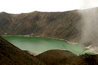
Volcán Azufral, at 4070m or 13353 ft, is a semi-active stratovolcano in the southwest of Colombia, about 15 km from the town of Túquerres. Its still considered active, but its last eruption was about a thousand years ago. So because of its low activity nowadays it's allowed to climb it. That it is still active can be told from the fumerolas and bubbling water that you can see on the shores of the laguna verde, the biggest of three crater lakes.
It lies within a reserve, the ‘Reserva Natural del Azufral’, which is easily accesible and can be visited free of charge. Azufral is Spanish for sulfur, which (together with iron) gives the water of biggest crater lake its green colour, after which the volcano was also named. Many local people refer more to the area as Laguna Verde, which is the most famous part of the volcano.
 View from the rim at the end of the trail.
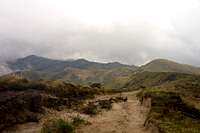 The trail through the páramo.
 Laguna Verde.
 On the shores of Laguna Verde.
The Reserva Natural del Azufral the volcano lies in covers an area of 6000 Ha at an altitude between 3200m and 4000m. About 476 different species of flora and 10 of fauna have been identified within the reserve. Among the most noticeable fauna you will find the frailejon and chupalla plants growing in between the paja (grass).
If you're lucky you can see the Sabana de Tuquérres, Nevado de Cumbal and Nevado de Chiles, and even Cayemba in northern Ecuador to the south, and Volcán Galeras to the east. The landscape consists mostly of a ‘páramo’ filled with ‘pajonales’ or areas of paja (grass).
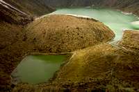
The top of volcán Azufral actually consists of a 2,5 x 3 km caldera containing a lava dome complex. There are supposedly nearly a dozen lava domes present, of which several still have active fumaroles to roast your marshmallows. Put your hands in one of them and see how long you can last! Beside laguna verde (3790m), the crater has two smaller lakes: the laguna crystal and the laguna verde (3765m).
The laguna verde is by far the biggest one, is about 1,5 km long and 600m wide and owes its colour to the presence of sulfer and iron. The acid water has an ph value of 3.5 according to a sign by the lake. It’s a beautiful sight with sulferic rocks and bubbling water on the main shores of the lake.
Getting There
 The trail from San Roque Alto.
 View of Laguna Verde from the rim at the end of the trail.
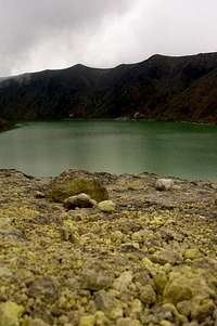 Laguna Verde from fumerolas hill.
 On the shores of Laguna Verde.
You can take a taxi to the cabaña de Corponariño, from where it is only 1,5 walking to the laguna verde. This saves you the bus ride and an hour walking. I don’t know how much the taxi ride would cost but I imagine it would be more than ten dollars.
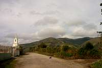
Or, you can take a bus from the central square of Tuquérres to the village San Roque Alto (800 pesos). Most part of the road is unpaved. Its not really a village, but rather a community of farms scattered around the hills. The bus driver will tell you where to get off if you mention laguna verde. On the hills above you will see a green house. That's the way you should be heading. Actually from where you get off the bus, the road goes all the way up to the volcano, you can’t get lost. It’s about 8km so that should take you 2,5 to 3 hours. After about an hour you get to an abondoned house with green walls.
Another twenty minutes walking from the green house and you get to the cabaña de Corponariño (Corporación Autónoma Regional de Nariño, the regional environmental agency). There was nobody there when I got there. It’s not really a refugio but I imagine you could spend the night here with your sleeping pad and bag (no beds) if someone lets you in. If you intend to do so, I would contact Corponariño in Pasto. The trail is accessible by car to this point. From here the road gets worse and you need to walk.
At the end of the trail, a winding road, you get to a viewpoint at 4000m from where you have a great view of the crater with the three laguna’s. From here it’s 800m down to the lake. The sandy trail has been improved with pieces of wood. On the way down you’ll pass a resting point with the roof partly blow off. On your left hand side there is a small hill, a lava dome with fumerolas.
From the trailhead in San Roque (where you get off the bus) to the rim of the crater should take you about 2,5 to 3 hours. From there it's about half an hour to get down to the lake.
When to go
 Laguna Verde and Laguna Crystal.
 On the shores of Laguna Verde.
You can hike to Laguna Verde year round, although some months have more rain than others. Generally speaking December-February and June-September you should get less clouds and rain. There tend to be less clouds in the morning, so get there early before clouds come cover the view of the lake! However, in this part of the world it seems like clouds are possible anytime so coming in the drier months is no garantee for great weather.
Red Tape & Camping
There isn't any red tape as far as I know. I'm not aware of any camping restrictions, there are plenty of spots where you could pitch your tent. Volcán Azufral is mostly visited from Pasto however, or if you are coming in from Ecuador you could stay in Ipiales. The cheaper hotels mentioned in the LP are good value, at less than 10 dollars per person for a room.