Overview
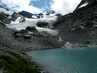
![The toe of the glacier at Wedgemount Lake]() Wedge Glacier
Wedge Glacier![Glacial Lake Ecstacy]() Rethel Mountain
Rethel Mountain
The trail to Wedgemount Lake is the access point for many a great alpine adventure in Garibaldi Provincial Park. To call this a trail is being charitable. It was probably never built; rather, it was almost certainly just beaten into the hillside by miners and explorers looking to reach their treasure with minimum delay. Consequently, not a single switchback graces this baby. It's up, up, up through thick forest, over slippery roots and rocks until you reach this alpine gem.
Once at Wedgemount, the possibilities are endless. There is easy access to the Wedge Glacier and from there the 9,500 foot summit of Wedge Mountain, the highest in the Whistler region. Also easily accessible are Mt. Weart, Parkhurst Mountain, Rethel Mountain, and Mt. Cook. All of these summits are worthy objectives in Garibaldi Provincial Park.
It is therefore not surprising, then, that the lake itself is somewhat forgotten amongst all of this splendor. This is a great day hike, all within minutes of a comfortable hotel room and great food and drink in Whistler.
To get to the trailhead, drive 7 miles north of Whistler on BC-99, looking for the Wedgemount Lake sign on your right. Turn off there, and drive 1.2 miles to the huge parking lot.
The Trip
![Tent Platforms at Wedgemount Lake]() Tent Platforms
Tent Platforms![Flowers by Wedgemount Lake]() Flowers by the Trail
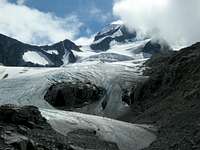
Flowers by the Trail![Looking up the Wedge Glacier]() Wedge Glacier
Wedge Glacier![Streams and Flowers around Wedgemount Lake]() Flowers and Braided Streams
Flowers and Braided StreamsOn the morning of August 13, 2008, I left Whistler at a leisurely time of 9:00 A.M. I was at the trailhead by 9:15, and even going at a leisurely pace, I was at the lake at 11:30.
The trail was brutal. There is no other way to put it. The stats tell the whole story, as the trail gains 3600 feet in 3.5 miles over rough, rocky, rooty dirt and mud. Soon after leaving the trailhead, I crossed over Wedgemount Creek over two separate bridges. The sound of the water falling over rocks is deafening here, and you definitely don't want to fall. After crossing over, the trail climbed through forest that looks like it's growing back after having been logged maybe 40-50 years ago.
Finally, after about a mile, I arrived in cool forest. From here, the trip is not especially notable until about the three mile marker. At this point, I broke out of the trees, and could see the cliffs of Mt. Weart, Rethel Mountain, and Parkhurst Mountains looming above me. As the trail climbed through marshy meadows, it came to a headwall, and then went straight up. This is probably the steepest part of the trip, and I was glad to have trekking poles for it. At the top of the headwall, I walked through alpine meadows of heather and flowers to Wedgemount Lake.
The lake is absolutely stunning. The Provincial Park has installed wooden platforms among the boulder fields surrounding the lake to provide a flat area to pitch your tent. There had to be at least ten of these wooden platforms. The authorities have obviously taken great pains to make sure that the vegetation in the area is not damaged. There were two structures at the lake; one was the BC mountaineering hut, and the other was an elevated latrine.
After a brief lunch, I walked down about 200 feet to the lake shore. There is a good trail that follows the shoreline of the lake. The Wedge Glacier's terminus nearly reaches the lake. In recent photos I've seen the glacier actually reached the lake, so there has been some obvious glacial recession here. There are numerous braided streams that come off of Mt. Weart to the north and wind their way to the lake. The stream beds are surrounded by fields of beautiful pink flowers. This was just a great place to hang around, admire the scenery, and take pictures.
I saw some climbers coming off of the Wedge Glacier and walking around the lake shore. They had been successful in their summit bid for Wedge Mountain. There is so much mountaineering close at hand here, I felt really sad that I was by myself and unequipped for a summit attempt. The next time I go, I will make a camp for 3 nights and try to tackle Wedge, Weart, and Parkhurst. If you come up here, all of the summits except Mt. Cook require knowledge of glacier travel techniques and equipment. The only problem with this is that I don't relish the idea of carrying all of that gear up that trail.


Comments
Post a Comment