
-
 3709 Hits
-
 71.06% Score
-
 1 Votes
|
|
Custom Object |
|---|---|
|
|
34.46925°N / 119.65884°W |
|
|
workshop |

 | Although many parties camp within the parking areas of the Alabama Hills, this practice is highly discouraged. The area suffers from mismanaged campsites and blackened caves. There are two campgrounds very close to the Alabama Hills. Lone Pine Campground is further up the road on Whitney Portal Road, and Tuttle Creek Campground is within a few miles up Horseshoe Meadow Road. If you don't mind driving another fifty miles, there are many campgrounds along Bishop Creek just to the west of Bishop. There are also many places in The Buttermilks area that are close to a creek that are suitable for camping. Please do not camp in The Buttermilks bouldering area. That area is very crowded and is suffering from the impact unregulated camping has caused. The following links should help finding a good campsite Horton Creek Campground Rock Creek Canyon Inyo National Forest Bishop Creek and vicinity camping |
==========================
 | |
|
External Links
CampingEl Capitan Beach Camping
Refugio State Beach Camping
Cachuma Lake
Los Padres National Forest
Weather
Santa Ynez Mountains
Santa Barbara
Cathedral Peak
La Cumbre Peak
Thunder and Lightning
 | ||
 |
 |
 |
=============================================
 |  |
 |  |
==========================================
 | |||
 |
 |
 |
 |
 | [img:894579:aligncenter:medium:] | [img:894862:aligncenter:small:] | |
===========================================

|  |  |  |
Ventura/Ojai weather
Ventura Beach Camping
Wheeler Gorge Campground/Ventura, Ojai camping
Emma Wood State Beach
Foster Park Campground
Foothill Crag
Black Wall
External Links
weather & Bishop links

Santa Barbara
Camping
Looking west from Earth Watch
Unfortunately, there are no campgrounds close and convenient to the city of Santa Barbara.
There is, however, one very large and well developed campground at Cachuma Lake, and a few less developed ones along Paradise Road off Highway 154. There are also a few campgrounds along Highway 101 at El Capitan State Park and Refugio State Park.
El Capitan Beach Camping
Refugio State Beach Camping
Cachuma Lake
How to get there

From Highway 101 take the Las Positas off ramp. For those coming from the south turn right; for those coming from the north turn left. In either case, drive toward the mountains to the north of Santa Barbara. Continue up Las Positas for .85 miles to State Street, where the name of Las Positas changes to San Roque. Continue driving straight toward the mountains until you come to HWY 192 (Foothill Road) in another .5 mile. Turn right at the intersection and continue up Foothill Road for 1.9 miles to its intersection with Mountain Drive. Turn left onto Mountain Drive and drive for .5 mile to its intersection with Gibraltar Road. Gibralatr Rock is about five miles from this point. You will recognize Gibraltar Rock located to the west of the road when you begin to see a large sandstone formation immediately to your right (east side of the road). This formation is “The Bolt Ladder.” Gibraltar Rock is a little further up the road and to your left.
Drive another two miles further up Gibraltar Road to its intersection with East Camino Cielo Road. From here continue another 1.8 miles to where Comino Cielo Road becomes level. There are many pine trees and a gate. Park your car by the side of the road and walk about ten minutes past the gate to the top of La Cumbre Peak. From the top of La Cumbre Peak drop down about 150 feet on a faint path to the top of the formation. There are two welded cold shuts for rappleing. You can also scramble through Manzanita bushes to the east of the formation and circle around to the base.
photo
===================================================================
The following text to The Alabama Hills page was produced by Misha. I am preserving this text for future reference and its historical value.
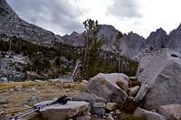
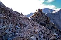
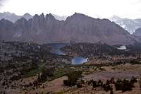
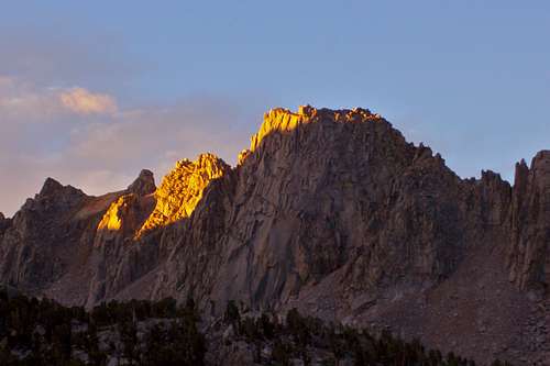
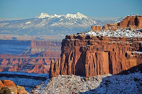
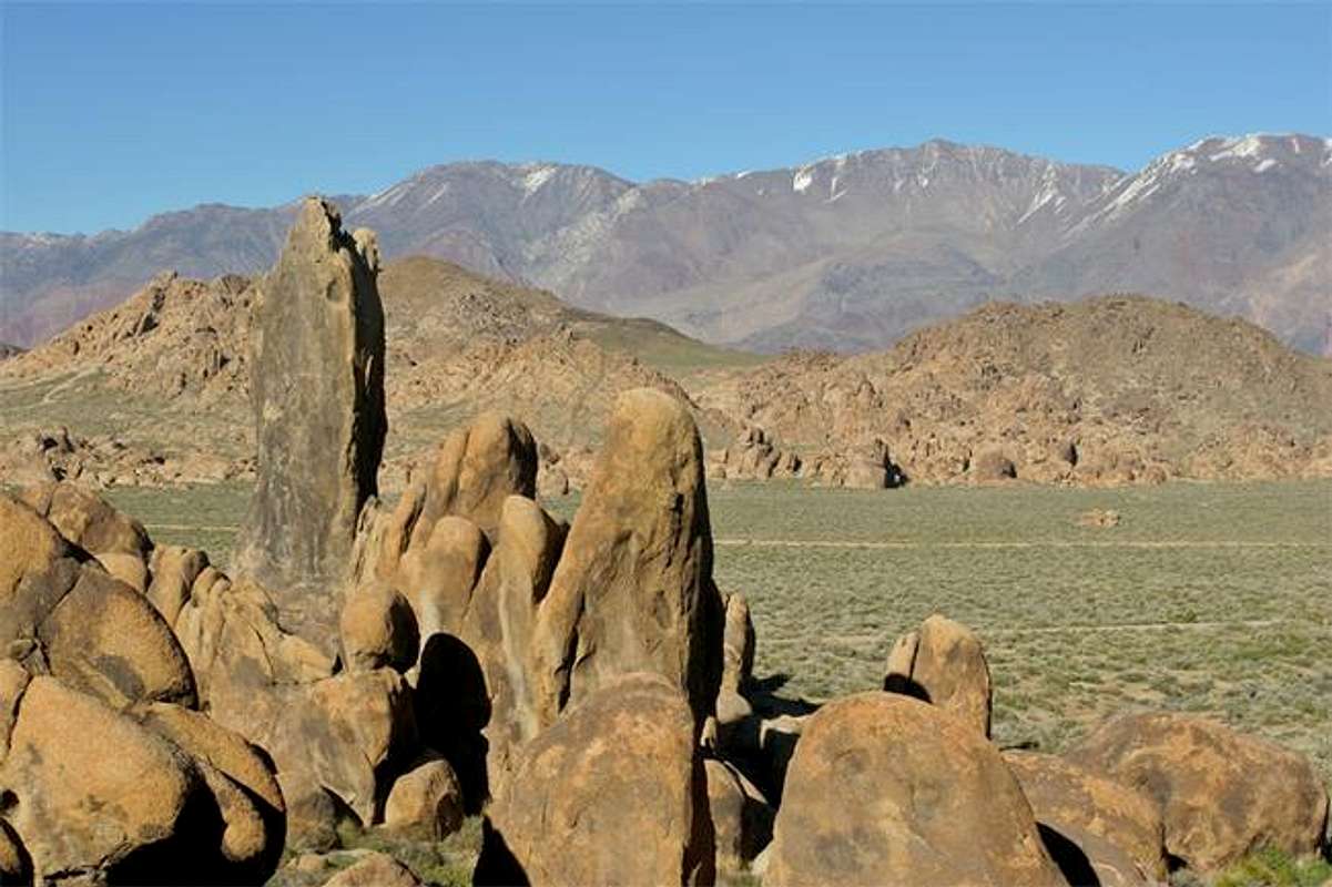
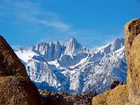
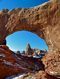
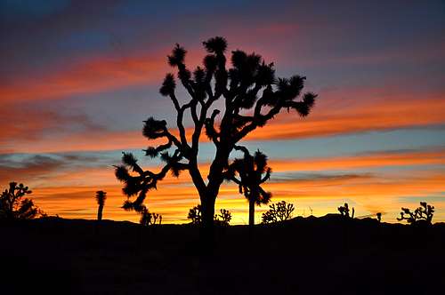
The Alabama Hills is a unique and wicked desert area in Owens Valley near the town of Lone Pine. It is known to the world as a popular movie location with a long, rich history of films shot there. The list includes hundreds of westerns, Gunga Din, Disney's Dinosaur, Tremors, Star Trek, G.I. Jane, The Shadow, Maverick, Gladiator, and many others. You may wonder what attracted Hollywood location scouts to this place. Take a look at the photos or, better yet, visit it and you will get your answer instantly. It looks out of this world with desert vegetation and patinated rounded boulders scattered over the area, and a massive backdrop of Eastern Sierra Nevada peaks rising nearly eleven thousand feet from the valley floor. It is also known for its proximity to the highest point of the lower 48 states, Mount Whitney.
If you like climbing in Joshua Tree, you will LOVE climbing in the Alabama Hills. Sun-burnt, coarse granite, an abundance of established routes, ease of access, seemingly endless first ascent possibilities (even now!), and fantastic weather make this a great cragging destination. There is something there for (almost) every climber: moderate faces, cracks, chimneys, desperate holdless sport problems, boulders, top-ropes, bumper-belays and even occasional run-outs. If you don't own a trad rack, don't get discouraged; there are many bolted routes that need nothing else but a set of quickdraws. However, if you despise single pitch routes, this place may not be for you. Most of the climbs are 100 or less feet tall.
Ratings are rather inconsistent with climbs within one rating feeling easy or hard for the grade. So take ratings with a grain of salt and trust your instincts. The rock quality is relatively good, although less popular routes may feature "portable holds" and choss. Knocking on potential holds to identify their "portability" and wearing a helmet at all times are just a couple of suggestions that you may want to consider while climbing in the area.
Some of the more notable and developed climbing formations are: The Whitney Cave; Alabama Dome; Arizona Domne; Shark's Fin; Paul's Paradise; The Poodle Wall; Cattle Pocket; Corridors; Dinosaur Cracks; Ghosts; Pillar of Toth; DMX Wall; Western Wall; Tall Wall; Hoodgie Wall and The Loaf . There are many other named and unnamed walls and boulders that can keep you occupied for weeks.
=============================================================
The Alabama Hills are located in the Lone Pine vicinity. To get to Lone Pine, take the "Eastern Sierra autobahn", US-395, which stretches from Reno, Nevada to the outskirts of L.A. Once you get yourself to Lone Pine, take Whitney Portal Road west. Soon you will reach the unpaved Movie Flat Road. You can turn right (north) here. Many formations are located near this road; just take any of the side roads when you see something interesting! A lot of popular climbing formations have small parking areas next to them. If you don't find a parking spot, please take some extra time to locate one instead of parking your beast on the fragile desert vegetation, and walk to your crag of choice!
==============================================================
Experimental frame
 |
|---|
Experimental frame II
Experimental Frame III
 |  |  |  |
|---|
| | | | |
|---|
Pywiack Dome


Tuolumne Meadows Camping
Saddle Bag Campground
The Sierra Web/Camping
Mono Lake Station- 760-647-3000
Rush Creek, Mammoth Lakes Station- 760-924-5500
Tangerine Falls Summit Trail landmarks
| Benchmark | Tangerine Falls Summit Trail coordinates | elevation | Distance from trailhead |
 Trailhead | N 34.45522--------W 119.65331 | 741 ft | 0 |
 Rusty old sign | N 34.45900-------- W 119.65414 | 940 ft | .25 mile |
 Take the right fork here | N 34.46492--------W119.65852 | 1250 ft | .5 miles |
 Summit rocky outcrops | N 34.47015--------W119.65928 | 1902 ft | just over 1.5 miles |
Frame 4
 |
|---|
| |
| |
Joshua Tree
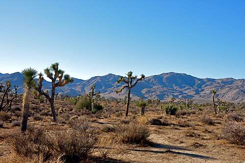
Typical Joshua Tree landscape
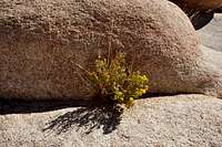
Desert Flowers
Please tread lightly. The Access Fund has gone to great lengths posting trail marker for approaches to many of the more popular crags. Do your best to stay on these trails, and where you are forced to use a different path, choose the ones that rain can mend in time. Drainages make for good trails where there are no established trails.
Avoid stepping on native and fragile plants, and do not feed the coyotes. Coyotes are very much used to people and often hang around picnic areas and camp grounds in hopes of getting a hand out. It’s better to let them live their natural life.
Camping
Joshua Tree Camping
Noise considerations
When you are camping with friends and sitting around the fire, it is easy to forget that there are other people trying to sleep in the nearby campsites. It is important to put yourself in their shoes. Keep the noise and music to a minimum and certainly not too much past 10 p.m. Your neighbors will smile at you in the morning instead of giving you dirty looks.
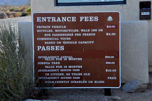
Fees and Food

Echo cove, north wall, left side
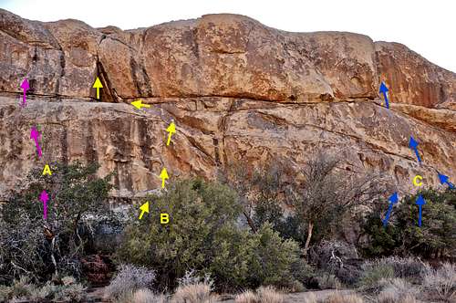
The north wall of Echo Cove is a large formation in the Echo Rock area of Joshua Tree National Park, California. Due to the extensive size of the north wall, I have chosen to divide this formation into two separate, left and right, sides. I will concentrate on the left side for this page.Located right across from the North Face of Echo Cove and the very famous and sought after route Big Moe, rated 11a, it should come as no surprise that this formation also receives a great deal of attention. In contrast to the opposite side, the north wall of Echo Cove is generally low angle and offers a number of easy to moderate routes. Another factor that helps this general area is that it's the first formation you come to as you enter Echo Cove from the west.
Most of the more difficult routes in this area are located on an adjoining formation further to the south, across from the descent chimney, the right side. But, the left side with all of it's easier routes sees a great deal of activity on regular basis. As you approach the formation, the first route you come to is a climb called Fun Stuff, rated 5.8. This route is so much fun that it deserves at least three stars. This route involves friction face climbing past two bolts to a hand crack in a corner. It finally reaches a solid double bolt anchor.
Moving further to the right, you have a huge slab surrounded by two crack systems. The crack on the left is Chute Up, rated 5.2, and similarly, the crack on the right is another easy route called Helix, another 5.2. These two routes are the keys to reach the top for setting a top rope on the main objective, W.A.C., rated 5.8. This route climbs up the middle of the large slab. W.A.C. has it's own double bolt anchor.
Another way to reach the top of the formation is to scramble up the chimney that separates the left and right sides. This chimney is often used for descending the formation.
 |
|
How to get there:

The north wall of Echo Cove is the formation on the left side of the photo
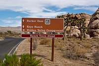
Just past Intersection Rock, take the road to Barker Dam for a short distance. Shortly after getting on this road you’ll see a sign for “Key’s Ranch” Road. Take this dirt road to a large parking area on the right. Just beyond the parking area there is a sign for “Key’s Ranch Guided Tours.” You can drive further on this road to access several other climbing formations, but you will run into a locked gate for “Key’s Ranch.” Walk along the dirt road and within less than a minute the South Face Of Echo Cove will be on your right, and right next to the road. Continue walking along the road to the end of the south face where you will see another small parking area. In front of the parking area there is a sign reading "Thin Crack" pointing you into the gully/cove. The North Wall of Echo Cove, left side, is immediately to your left.
25
 |
|
20
Although there is at least one other alternative route to gain the summit of Arlington Peak, the East Ridge is by far the most desirable and popular. Some people who are very familiar with this mountain climb the East Ridge and descent via the south face to eventually connect up with the Inspiration Point Trail. The East Ridge, by its very nature, is airy and scenic. You get a great view of Mission Canyon, Mission Ridge and Tunnel Trail to your right and Jesusita Canyon and other California coastal peaks to your left. On a clear day, the views of Santa Barbara Channel Islands National Park are truly grand.The East Ridge of Arlington Peak is rocky and you will find yourself scrambling on, over and around countless boulders. There are at least two short rocky tunnels you will have to go through or use to escape from the sun or the rain. There are also a number of caves and caverns to explore, or you simply sit on top of boulders to take a break and have lunch. Looking up the East Ridge you may think that you are looking at the summit. Unfortunately, what you see from down below is not the summit. The true summit is just beyond a large peace sign painted on a rock and visible about quarter of a mile before reaching it.
East Ridge Route Description:
The first mile of this trail is the same as Inspiration Point. After crossing Mission Creek on rocks, look for a trail climbing steeply to the right of Inspiration Point Trail and to the left of the creek. This is your trail and it parallels Mission Creek for a short distance. Then, just past a rock that juts out over the canyon to your right, take a fork that heads steeply to the west, your left. From this point on you should have no problem following the trail to the foot of the East Ridge. This is a flat spot with several boulders and view of the Santa Ynez Mountains and Tunnel Trail. To get to this point, you will be hiking mostly on a dirt trail interspersed with short rocky steps.
From the foot of the ridge drop down about seven feet to gain the trail again. From here the trail winds up and around boulders on fairly low angle ground to pass by a rock formation to your left and a great view of Mission Creek to your right. This section is kind of exposed but it gives you a great view of the waterfalls and swimming holes way below your feet. Shortly after this section you will have to scramble up a class 2 boulder and hop over several other boulders to where the ridge begins to get steep. After passing by a pine tree to your right and a cave to your left, you will crawl through a short tunnel. Climbing up many more rocks and boulders will take you to a second and longer tunnel. Follow the path of least resistance to the top of the false summit.
Looking up from the vicinity of the false summit, you should be able to see a peace sign visible from here. The trail continues to climb on rocks and dirt trail to the peace sign to your right. The actual summit block is a short distance beyond this point and it is made of several large boulders stacked up on top of one another. Enjoy
Trailhead Elevation: 1002 ft
Summit Elevation: 3258 ft
Actual miles: Approximately 3 miles
How to get to the trailhead:
From US Highway 101 in Santa Barbara take the Mission Street off ramp and turn right at the light. Continue on Mission street passing in front of the mission building to a stop sign at the intersection with Foothill Road. Turn right onto Foothill Road and left onto Tunnel Road. You will come to a fork. Take the left fork and drive all the way to the end. You can park on the right hand side of the road within the white lines. Additional parking may be found before the end of the road. Please do not park in the side streets. They are all private roads.
17
Arlington Peak is located to the southeast of Cathedral Peak and to the south of La Cumbre Peak in the Santa Ynez Mountains of Los Padres National Forest, California.For many years this beautiful peak did not have a name of its own. Everyone I knew referred to it as Cathedral Peak, and the rock formation to its northwest as Cathedral Rock. At some point in time Google Map changed the name of Cathedral Rock to Cathedral Peak and out peak was left without a name. I am not sure who or at what point in time the name of Arlington Peak was chosen for our beautiful little mountain. Even to this day, the printed maps don't show a name for Arlington Peak.
Even though Arlington Peak is by no means the highest point in the santa Ynez Mountains, it is visible and distinguishable from miles away. Its pyramidal shape, its rocky south face and its steep east ridge make this mountain stand out amongst the background hillsides. After the forest fires of May of 2009, the true majesty of Arlington Peak became obvious. The rocky formations that were covered by sage brush displayed their true size. Someone has commented "This mountain looks like a woman who has taken off her cloths."
Climbing Arlington Peak is not just another hike up a dirt trail. You are following a ridgeline that is open and scenic. You find yourself scrambling on, over and around rocks and boulders. The views from the top are truly breathtaking. Since this mountain sits in front of the main Santa Ynez ridgeline, the summit views are much greater in perspective. You get an uninterrupted views of the California coastline in both direction, southeast and west. The views of Santa Barbara Channel Islands National Park against the blue Pacific Ocean are something to behold. Closer up, you get the best view of Mission Ridge and Tunnel Trail and how exactly it snakes its way all the way up to Camino Cielo Road and La Cumbre Peak.
How to get to the trailhead:
From US Highway 101 in Santa Barbara take the Mission Street off ramp and turn right at the light. Continue on Mission street passing in front of the mission building to a stop sign at the intersection with Foothill Road. Turn right onto Foothill Road and left onto Tunnel Road. You will come to a fork. Take the left fork and drive all the way to the end. You can park on the right hand side of the road within the white lines. Additional parking may be found before the end of the road. Please do not park in the side streets. They are all private roads.
The hike:
The hike begins the same as the trail for Inspiration Point. After crossing Mission Creek on rocks, you will see another trail to the right of Inspiration Point trail. This trail is steep and parallels Mission Creek for about quarter of a mile then climbs steeply to the west, left. Follow this trail to the foot of the east ridge. Follow the east ridge that climbs over and around countless boulders and rock formations to the rocky summit of Arlington Peak. The true summit is just past a large peace sign painted on a rock with white paint and visible from the top of the false summit.
N & S Horror Rocks
 |  |  |  |
Billboard Buttress
34.09318 -116.1554Billboard Buttress is a formation in the Indian Cove area of
Indian Cove Campground is surrounded by rock formations such as Pixie Rock and Moosedog Tower. Pixie Rock guards the northern flank of the entrance into the campground and Billboard Buttress the southern flank. These two formations are great stopping places for many climbers. The biggest attraction about Billboard Buttress is that it offers a number of easy to moderate routes. In contrast to many formations in the Indian Cove area, Billboard Buttress is not located behind a campsite. This feature alone makes this rock to climb on.
-------------------
If there is one place in the Indian Cove area you could see many people bouldering, it is on the base of Billboard Buttress. For most people the first six to eight feet of the smooth and difficult start to Gait of Power, rated 10b, is sufficient to get satisfaction and still stay within jumping down height, or down climbing to the right. Note: The start of Gait of Power is shown in light blue. The best way to do anything higher, however, is to use a rope, essential equipment, and a partner.
There are a number of moderate routes on this formation. If you are in the mood for a great hand crack, consider The Reverend, rated 5.8. This is a crack inside a dihedral on the right hand side of the west face. Another highly recommended climb is a face route on the south face called Driving Limitations, rated 5.8, and protected by a few bolts.
------------------------
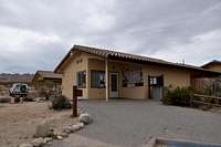
Entrance to the park/Ranger Station
Indian Cove is located roughly nine miles north of the town of Joshua Tree on highway 62. The sign directing you to Indan Cove is obvious. Turn right, going south, here. If you go as far the town of 29 Palms, you have gone too far. It’s about three miles from here to Indian Cove Campground. Drive south on this road to a ranger station and the enterance to the park. You will be checked at the gate for your America The Beautiful card, or will be charged an enterance fee. Driving past the gate will bring you to the Indian Cove Campground. Billboard Buttress is to your left just before entering the campground.
Experimental Frame V
------------------

21
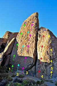
Houser Buttress is a rock formation in the Real Hidden Valley area of Joshua Tree National Park, California.During the cold winter months when most climbers hands are too cold to even touch a rock, there is one great option. The place is Joshua Tree National Park, and the rock is House Buttress. This beautiful eighty foot formation is south facing and warms up nicely within a few hours after sunrise. The ease of access is another advantage about this formation, only a few hundred yards west of the parking lot with a well-travelled trail.
It should come as no surprise that House Buttress was noticed and climbed early in history of technical climbing in Joshua Tree. Looking at the history of the area, the names of a handful of climbers seem to keep coming up. One of the most prolific figures with several first ascents in this area is none other than Herb Laeger.
----------------
By the late 1970s, having fewer than half of a dozen routes, things were not going to stay the same for Houser Buttress. During the following twenty years numerous routes on the neighboring formations were established that turned the area even more popular than ever. Amongst all of these routes, one has stood above all the rest in popularity even to this day. The route's name is Loose Lady. Loose Lady offers what face climbing in Joshua Tree is all about. The rock is not quite vertical, use of friction and tiny edges are vital in making it to the top of this route. There has, however, some disagreement as to the difficulty rating of Loose Lady. Originally rated at 10b, the getting demoted to 5.8, then 5.9, 5.9+. In my humble opinion, Loose lady well-deserves a 10a rating.
In addition to Losse Lady, there are number of great climbs on this formation such as "Dummy's Delight," rated 5.9, a curving crack well to the right of Loose Lady. If you are looking for a much greater challenge, you can try "Herbie's Hideaway, rated 10d. This is a very thin crack shown on the topo with letter E. This is another one of Herb Laeger's first ascents in this area.
-----------------------------
From the parking lot, walk about quarter of a mile west on a well-travelled trail to Howser Buttress.