
|
|
Area/Range |
|---|---|
|
|
37.80000°N / 20.75000°E |
|
|
Hiking |
|
|
Summer |
|
|
2480 ft / 756 m |
|
|
Overview
The third largest of the Ionian Islands, Zakynthos lies 8.5 miles to the south of Cephalonia Island with its most northerly point, Schinari, opposite Mouda at the southern tip of Cephalonia. It is roughly 125 km long, and covers an area of 410 square kilometers. To the east, at a distance of approximately 9.5 miles, is the coast of the Peloponnese to which the island is linked by a frequent ferry service (the trip from Kyllini to Zakynthos takes about an hour and a half). The narrowest opening between the island and the mainland is between Trypiti in the Peloponnese and Kryoneri on Zakynthos.
The terrain is varied; there are plains in the eastern part which merge gently into peaceful bays and golden beaches, while the western side of the island is mountainous with steep cliffs along the coastline.
 Navagio Shipwreck
Although the mountains are not particularly high, they occupy a fair portion of the island. The highest is Mount Vrahionas (756 m)(Oros Vrahionas), while other mountains of note are Kaki Rachi (680 m), Mount Atheras (583 m) and Mount Skopos (483 m), with some lower ones that together form a small plateau.

Cliffs above the sea

Blue Paradise

Zakynthos scenery

Navagio Shipwreck

Blue Cave

Navagio beach

Keri

Navagio scenery

Keri

Navagio

Impressive Zakynthos

Inside of Blue Caves

Careta Careta

Blue Caves

Zakynthos Beauty

Navagio Shipwreck

Navagio
The main bays are at Laganas, in the south, which has a superb sandy beach that stretches for 90 kilometres, Tsilivi, Alykes and Schiza. The most important promontories are those at Schinari and Marathia, at the island’s northernmost and southernmost points respectively; Keri in the south-west, Yeraki on the north-eastern coast of the island, and Kryoneri which lies to the north of the town of Zakynthos. Laganas Bay encompasses the rocky and uninhabited islets of Marathonissi, Agios Sostis and Pelouzo, with the Strofades islands (which belong administratively to the prefecture of Zakynthos) lying about 75 km, to the south.
Zakynthos has many underground streams which are fed by a number of wells and springs; the island is therefore blessed with abundant waters, which together with its fertile soil guarantee a plentiful supply of agricultural produce. The island’s main products are oil, grapes, wine, citrus fruits, potatoes and onions, while the upland pastures favour animal-rearing. From a geological viewpoint the island is of great interest. Geologists believe that in the distant past Zakynthos was part of a submarine plate which was pushed up as a result of powerful earthquakes to form an island.
The major geological realignments in this marine region resulted in the creation of a great many islets, reefs and underwater shelves. They also caused the opening of a huge underwater fault known as "The Well of Inousses" to the south-east of Zakynthos, where the Mediterranean attains its greatest depth (approx. 4500 m).
As a result of the intense geological activity in the region some remarkable caves were formed on the island, both on land and in the sea. Some of these are extremely interesting and there is access to many of them. The soil of Zakynthos contains gypsum, sulphur and hydrocarbons. In the southern part of the island, near Keri, bituminous water gushes out of the ground, but drilling of boreholes in the area in search of oil has proved fruitless.

Wild beauty
The climate of the island is mild, with gentle winters and cool summers. The abundant rainfall, in contrast to the rare occurrence of snow, favours the growth of vegetation and ensures considerable water reserves, which is why the island is so green. Aparth from the olive groves and vineyards, orchards full of citrus trees and every other kind of fruit, areas of garden produce and cereals, much of the island is forested and, on some of the beaches, trees grow right down to the water’s edge.
The island’s rich vegetation and serene natural environment, its peaceful landscape unruffled by the rocky protuberances of the mountains which instead merely add veriety, an innate feeling of langour that seems to pervade every corner of the island – whether by the seaside or up in the mountains – all these contribute to creating and illusion of paradise. It may not be quite so primitive but there is no doubt that it is a latter-day Paradise on Earth.
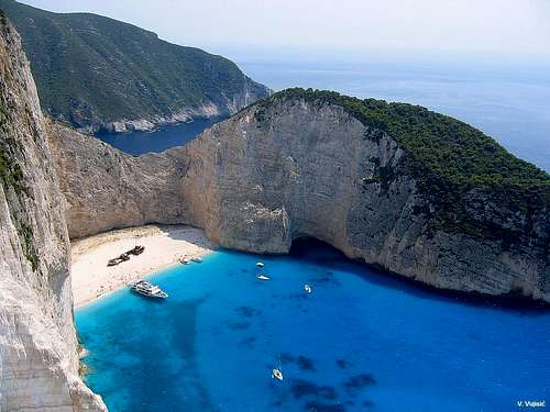
Zakynthos is the home of one of most beautiful, most impressive and most photographed beach of Greece and also of the rest of the world - Navagio Shipwreck. This wonderful beach with it's unreal blue water, located belowe the high white cliffs, attrack year after year thousands of tourist worldwide to visit this Paradise on Earth.
Also, we can't forget to say that one of the most famous trademarks of Zakynhtos is turtle called Careta Careta, with it's approximately length 1.20 m.
So, welcome to visit greek Paradise on Earth!
Getting There

Navagio in sunset

Impressive Navagio

Blue-White World

Wild Beauty

Pure enjoyment

High above the sea
HOW (TIMETABLE) to get Zakynthos (Zante) Island, Greece:
A. From Athens to Zakynthos Island by:
Airplane from the Athens International Airport "Eleftherios Venizelos"
Athens International Airport “Eleftherios Venizelos”: Tel. +30 210 353-0000
Olympic Airlines Athens: Tel. +30 210 966-6666 or 801-11-44444
Bus from the Athens KTEL Intercity Bus Station to Kyllini and then Ferry boat from Kyllini Port
Athens Intercity Bus Station: Tel. +30 210 515-0785
Kyllini Port : Tel. +30 26230 92211
B. From Thessaloniki to Zakynthos Island by:
Airplane from the "Macedonia" Thessaloniki Airport
"Macedonia" Thessaloniki Airport: Tel. +30 2310 985-000 or +30 2310 473-212
Olympic Airlines Thessaloniki: Tel. +30 2310 368-311
Bus from the Thessaloniki KTEL Intercity Bus Station to Kyllini and then Ferry boat from Kyllini Port
Thessaloniki Intercity Bus Station: +30 2310 595-411
Kyllini Port : +30 26230 92211
From Zakynthos to Athens and Thessaloniki by:
Ferry Boat or Airplane
Zakynthos Port: Tel. +30 26950 28117
Zakynthos Airport Tel. +30 26950 29500 or +30 26950 29505
Olympic Airlines Zakynthos: Tel. +30 26950 28611
Zakynthos Intercity Bus Station: Tel. +30 26950 43850
From Zakynthos (Zante), visitors can also fly to the airports of other Ionian Islands (Kefalonia & Kerkyra) and Preveza town in Epirus or take a boat to Kefalonia. For more information, kindly contact the Zakynthos Airport and the Zakynthos Port.
Other Zakynthos authorities:
Zakynthos Police: Tel. +30 26950 24480
Zakynthos Tourist Police: Tel. +30 26950 24483
Zakynthos Town Hospital: Tel. +30 26950 59100

Zakynthos town

In the Paradise
How to get to Mt Vrahionas

On the summit
From all of the mountains of Zakynthos Island, Mt Vrahionas (756 m) is the highest one.
Getting There:
- Zakynthos-Machairado-Ag. Nikolaos-Ag. Leon-Gyri
- Zakynthos-Katastari-Alykes-Anafonitria-Maries-Exo Chora-Ag. Leon-Gyri
Camping
You can freely camp on many places on Zakynthos Island. You can put your tent on many beautiful places on Zakynthos, below and around the Mt Vrahionas (756 m) and near the edge of many high cliffs above the sea.
Maps

Zakynthos Map

Zakynthos area map
Red Tape
No extra fees.