Getting Started
Being in Pennsylvania on business for 9 days in April was a perfect excuse to begin highpointing. Now I'm from Montana, where you can drive for 10 hours and still be in the same state. When I saw that I could reach 3 state highpoints in a matter of about 4 hours, I was thrilled. So I made a plan.
I was on the wrong side of Pennsylvania from Mount Davis, so it would take a 4 hour roadtrip to get there. Then, just a matter of heading South for a little over an hour to BackBone Mountain in Maryland, and another hour and a half or so South to Spruce Knob in West Virginia. Piece of cake.
I had to work Saturday morning, on the 16th of April, but if I was able to be on the road by noon, I could still hit all three highpoints before dark. At work, I printed off the SP page of each highpoint and a Yahoo Maps list of driving directions, since my rental car didn't have a GPS. At noon, my spirits were dashed - some of my coworkers had not completed their work properly and we were delayed. At about 1:30, 90 minutes behind schedule and nervous about sunset, I got on the Pennsylvania Turnpike headed West.
I sped down the highway doing math in my head. If I could get to Mount Davis at 5:30, maybe I could be at Backbone by 6:45, and maybe Spruce Knob by 8:00 or so, which should be right after sunset, but still light enough to take pictures. I knew I didn't have a lot of time to waste, so I planned on quick visits at all three with no time for sight-seeing.
Mount Davis
As I approached the interstate exit for Salisbury, PA, I found myself scanning the skyline to see if I could see which hill I would be standing on in a few minutes. My anticipation had been growing and I could barely hold still in my seat. I arrived in Salisbury, PA right on time with the sun still high in the sky. This was to be my first highpoint, so I was very excited. I had my SP page of Mount Davis in hand, which said the highpoint was well-marked from the road. Once again my hopes were dashed as I drove straight through Salisbury heading North without seeing any signs. After a couple miles, I turned around and drove more slowly through town, and there it was. I had driven right by it, a sign for Mount Davis.
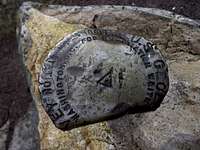
![The benchmark at Mount Davis]()
The next 20 minutes were spent navigating the maze of roads that encircle Mount Davis. I was maddeningly trying to find the highest terrain knowing that I was burning daylight. Finally, I found and parked at the parking lot right near the summit. I jogged to the actual highpoint for a few pictures, ran up the observation tower for the view and pictures and then jogged back to the car. The view was worth it and I was stoked. My heartbeat had picked up quite a bit because of my excitement. I'm really a nerd when it comes to this stuff. Now, it's time to hit the highway for Backbone Mountain.
Backbone Mountain
I knew I would only have daylight for 2 of my 3 highpoints, because I had planned on being done with Mount Davis by 5:30, but didn't leave Salisbury, PA until 6:30. I would be at Backbone Mountain pretty close to sunset and I knew it would be dark at Spruce Knob. But I was elated to have made it to the highest point of Pennsylvania. My highpointing hobby was officially underway.
Backbone Mountain's trailhead was much easier to find. There is a sign for the trailhead right on the highway. I parked on the edge of the highway at a dirt pull-out and grabbed my camera. The SP page said this was about a 1 mile hike, so I didn't want to waste any time. I started jogging up the trail with even more enthusiasm than I had at Mount Davis.
Then I lost the trail. I didn't think it was a big deal because this was not a large mountain. As long as I continued going to higher and higher ground, I would find the highpoint. As I approached what I thought was the top, I saw ... a house. Oops, I had stumbled onto private property. I looked around and, to my right, there was ground that looked like it might be a little higher but it was tough to tell. I was in a forest at dusk.
Then it started to rain as it continued to get darker. I wasn't sure if I was going toward the highpoint or not. All I knew was that I was in a forest and I had stopped gaining much elevation of any kind. After stumbling around for about 20 minutes, I was about to head down the mountain. I was wet and getting frustrated.
Then I saw the cairn. About 50 yards away was the highpoint of Maryland. I snapped a couple pics and started jogging down the mountain. It was dark and I'm probably lucky I didn't break an ankle. I got to my car, soaking wet, and mentally exhausted. That was much more of an ordeal than it should have been. But, mission accomplished. On to Spruce Knob.
Spruce Knob
Little did I know that on the highway between Backbone Mountain and Spruce Knob, there is very little cell phone service. I noticed that my cell phone didn't have coverage, and it was now dark. Reasoning that I wouldn't be out of cell phone coverage for long, I pressed on.
As I reached the base of Spruce Knob, I still didn't have cell service and it was now pitch black outside. I figured I would have service at the top of the mountain, so I started driving up. This is a fun road. It's well-maintained, paved pretty much the whole way, and curvy with occaisonally great views. I would have loved to see this in the daylight. If I ever get back to West Virginia, I'm definitely doing Spruce Knob again.
When I got to the top, the fog had rolled in and it was windy. The wind must have been blowing at 50+ MPH. And it was sustaining those gusts. I parked so that my headlights shined on the West Virginia Highpoint sign, so I could get a decent picture. As I got out of the car, I realized just how dark it had become. I was alone and nobody really knew where I was. As that realization hit me, I was pretty darn fast at taking my picture and getting back in the car.
Then I realized I still didn't have cell coverage. I cruised down the mountain eager to get back on the road, so I could get back in cell phone range and back to my hotel.
Back to the Hotel
Turns out I didn't get cell phone reception until almost Harrisonburg, VA. I didn't have ANY cell phone service ANYWHERE in West Virginia. The trip home was mostly uneventful, just long. It seemed longer because I was getting pretty tired.
I missed the Pennsylvania turnpike exit (probably due to fatigue), and had a rather interesting detour through Harrisburg, PA, before finishing up my trip, arriving back at my hotel in Morgantown, PA at approximately 2:30 AM.
What a trip! I had done it, even though I had lost my way in my car at Mount Davis, lost my way on foot at Backbone Mountain, and lost cell phone service in the entire state of West Virginia. My first 3 highpoints, all in one day, and all late in the day. I slept like a baby that night.


Comments
Post a Comment