


-
 5732 Hits
-
 81.18% Score
-
 13 Votes
|
|
Route |
|---|---|
|
|
45.67910°N / 7.38464°E |
|
|
Mountaineering |
|
|
Summer |
|
|
Note
|
La montagna chiama i suoi figli, ed essi rispondono fedelmente al suo appello… Osvaldo Cardellina, Diario alpinistico, 1964-65 Page texts: @ OsvaldoCardellina "Osva", passed away on May 2, 2022. Page owners: Christian Cardellina e Osvaldo Cardellina. Any updates from September 12, 2022: Antonio Giani, page administrator, friend and climbing companion. Testi della pagina: @ OsvaldoCardellina "Osva", scomparso il 2 maggio 2022. Proprietari pagina: Christian Cardellina e Osvaldo Cardellina. Eventuali aggiornamenti dal 12 settembre 2022: Antonio Giani, amministratore della pagina, amico e compagno di salite. |
Overview
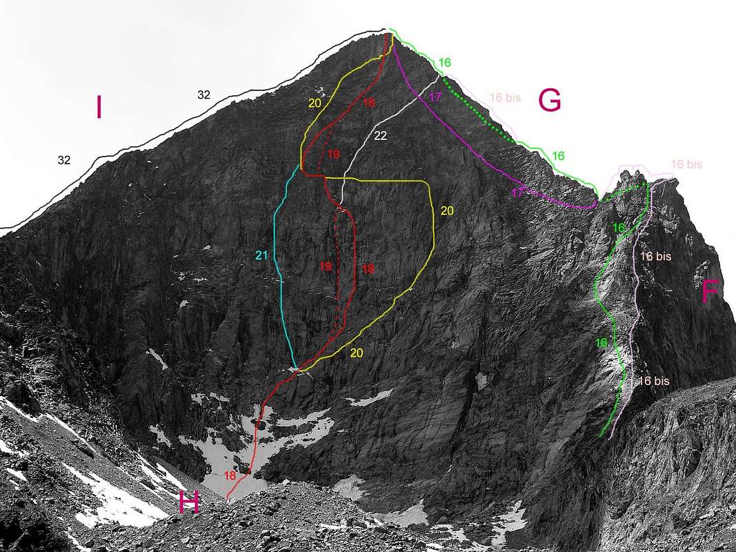
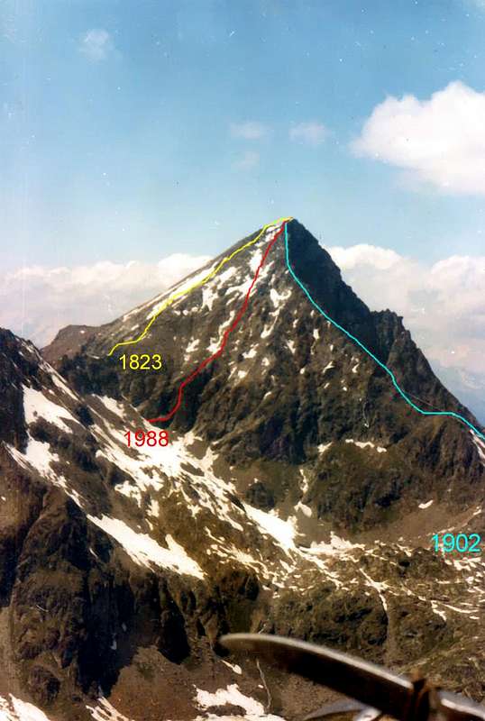
This page is to provide a more thorough completion of its appearance in "33 ROUTES OF MONTE EMILIUS First and Third Parts", both in terms of the Foundamental Routes that the Variants. The aim is to give at the bottom of each photo, the relative dating of the latter, in order to facilitate the overall picture.
In the previous two parts instead of the routes had been indicated in a clockwise direction, always starting from the S-SE Ridge or Normal, with a code number by 1/33 and variants with the latin addition of bis, ter, quater etc.. The same procedure is maintained in the photo captions with the same initials, so as not to create confusion and make the unit work. The purpose of this is to "offer" two pictures of each side, with different angle in order to better identify the various ways with their studies, but nevertheless keep in mind that the same have a margin of error from 80% to 95 % approximately, according to the difficulty inherent in the same. In fact, a via is more challenging and greater precision of traceability involves and obtains; other types of path, besides not always required, may differ, though not excessively, from the original path while maintaining the logic path. The motivation lies in the fact that relations are taken from very old books and magazines that often merely state a dotted line, but not exhaustive, of course. This also applies to old photos or sketches, because the accuracy is not of this world. In other cases, the authors of the routes, including myself, can no longer, with the passing of years if not decades, to focus in a perfect way the itinerary followed. This is normal, at least for me the experience comfort on routes which offer numerous possibilities of variation in the ascent.

Will propose the analysis on four fronts, namely:
1) - South, Southwest and West-southwest, which is considered unique, since all the faces, the walls, the spurs and ridges in the Walloon of Arbolle;
2) - Buttress of South-southwest, seen from the West or from the Slope of Comboé;
3) - North Slope of the Northwest Ridge of Mount Ròss of Comboé ie the Carrel Hill, with the walls of Mount Ross, the Little Emilius, Emilius and the Black Triangle, North-northeast Edge inclusive, all aimed at the Walloon of th'Arpisson;
4) - Eastern Slope, with the East Wall "locked in" between that Edge and the East Ridge or of Brissogne, projected onto the slopes of Laures Walloon;
5) - Southeast Face or the Upper part of the Vallon of Laures, between the East Crest and the Normal Route "of the Three Capuchins".
This we are about to do is not an easy job and fast, but take rather difficult and that, in spite of the experience gained in this area in nearly Half a Century, requiring great Patience & Careful Sum. Nevertheless, some errors will come out. Not immediately, but in time. Hope for the best ...
Questa pagina vuole essere solo un completamento più minuzioso di quanto apparso in "33 ROUTES OF MONTE EMILIUS First and Third Parts", sia per quanto concerne le Vie che le Varianti. Lo scopo é quello di dare in calce ad ogni foto la datazione relativa alle medesime, onde facilitare il quadro di insieme.
Nelle due precedenti Parti invece le vie erano state indicate in senso orario, sempre partendo dalla Cresta S-SE o Normale, con una sigla tramite numerazione 1/33 e Varianti con aggiunta di bis, ter, quater ecc. Lo stesso procedimento viene mantenuto nelle didascalie delle foto con le medesime sigle, onde non creare confusione e rendere il lavoro unitario. L'obiettivo del presente é quello di "offrire" due foto di ogni versante, con angolazione diversa allo scopo di meglio individuare le varie vie con il loro percorso; ciononostante bisogna tenere presente che le medesime hanno un margine di errore dallo 80% al 95% circa, in base alla difficoltà insita nel medesimo. Infatti più una via risulta impegnativa e maggior precisione di tracciabilità comporta ed ottiene; altre tipologie di percorso, tralaltro non sempre obbligato, possono discostarsi, anche se non eccessivamente, dal percorso originale pur mantenendo la logica di percorso. La motivazione consiste nel fatto che le relazioni sono tratte da libri molto vecchi e da riviste che spesso si limitano ad esporre un tratteggio lineare, ma non esaustivo, del percorso. Ciò vale anche per vecchie foto o schizzi, perché l'assoluta precisione non é di questo mondo. In altri casi, gli stessi autori delle vie, me compreso, non riescono più, con il passare degli anni se non dei decenni, a mettere a fuoco in modo perfetto il percorso seguito. Ciò rientra nella norma, almeno per quanto mi conforti l'esperienza, su percorsi tali da offrire numerose possibilità di variazione nella salita.
Nelle due precedenti Parti invece le vie erano state indicate in senso orario, sempre partendo dalla Cresta S-SE o Normale, con una sigla tramite numerazione 1/33 e Varianti con aggiunta di bis, ter, quater ecc. Lo stesso procedimento viene mantenuto nelle didascalie delle foto con le medesime sigle, onde non creare confusione e rendere il lavoro unitario. L'obiettivo del presente é quello di "offrire" due foto di ogni versante, con angolazione diversa allo scopo di meglio individuare le varie vie con il loro percorso; ciononostante bisogna tenere presente che le medesime hanno un margine di errore dallo 80% al 95% circa, in base alla difficoltà insita nel medesimo. Infatti più una via risulta impegnativa e maggior precisione di tracciabilità comporta ed ottiene; altre tipologie di percorso, tralaltro non sempre obbligato, possono discostarsi, anche se non eccessivamente, dal percorso originale pur mantenendo la logica di percorso. La motivazione consiste nel fatto che le relazioni sono tratte da libri molto vecchi e da riviste che spesso si limitano ad esporre un tratteggio lineare, ma non esaustivo, del percorso. Ciò vale anche per vecchie foto o schizzi, perché l'assoluta precisione non é di questo mondo. In altri casi, gli stessi autori delle vie, me compreso, non riescono più, con il passare degli anni se non dei decenni, a mettere a fuoco in modo perfetto il percorso seguito. Ciò rientra nella norma, almeno per quanto mi conforti l'esperienza, su percorsi tali da offrire numerose possibilità di variazione nella salita.
Verranno proposte le analisi su quattro versanti, ovvero:
1) - Sud, Sudovest e Ovest-sudovest, che viene considerato unico, essendo tutte la facce, le pareti, gli speroni e le creste rivolte al Vallone di Arbolle;
2) - del Contrafforte Sud-sudovest, visto da Occidente ovvero dal Versante di Comboé;
3) - del Versante Settentrionale dalla Cresta Nordovest del Mont Ròss de Comboé cioé dal Colle Carrel, con le pareti del Mont Ròss, del Piccolo Emilius, dell'Emilius e del Triangolo Nero, Spigolo Nord-nordest compreso, tutti rivolti al Vallone di Arpisson;
4) - Versante Orientale, con la Parete Est "rinchiusa" tra il suddetto spigolo e la Cresta Est o di Brissogne, vie proiettate sul Vallone des Laures;
5) - Versante Sudest o della parte Alta del Vallone des Laures, tra la Cresta Est e la Via Normale "dei Tre Cappuccini".
Questo che ci apprestiamo ad effettuare non é un lavoro facile e veloce, bensì pittosto difficoltoso e tale, nonostante l'esperienza acquisita in questa area in quasi mezzo Secolo, da richiedere grande Pazienza e Somma Attenzione. Ciononostante qualche errore verrà fuori. Non subito, ma nel Tempo. Speriamo in bene ...

Routes & Variations Description
Via |
With regard to the description of the various climbing routes to remember to note that in this paper we will consider only two aspects:
1) - to topographical, or the conformation and orientation of ridges, spurs, slopes and walls;
2) - the "practical/aesthetic", which roughly follow the line while climbing or rock climbing.
For all other assessments (difficulty together, the relevant passages in the rock or soil mixed, glacial slopes of the faces expressed in degrees, height difference and overall development of the via in meters) refer to the "First Part", always the same, please refer to regarding aspects and historical place names. In this context of historical news of the ascent of the same authors and composition of the roped in first ascents, winter ascents or lonely you indicate the first three parts of the work with a particular address, concerning the history of Mount Emilius, addressed to "Second Part" always "33 ROUTES oF MONTE EMILIUS (3.559m)".
The primary objective of this page, as mentioned above, is being able to focus better on the line of comparing it to two different points of view (as well as more panoramic pictures or others with the details); in other cases, such as the Northern Slope, it is instead seen fit, given the excessive number of existing routes, to divide the climbs in two historical periods, with tracing only those relating to the respective.
 |
Per quanto concerne la descrizione delle varie vie di salita c'é da osservare che in questo lavoro si prenderanno in esame soltanto due aspetti:
1) - quello topografico, ovvero la conformazione e l'orientamento di creste, speroni, versanti e pareti;
2) - quello "pratico/estetico", ovvero la linea approssimativamente da seguire durante la salita o l'arrampicata.
Per tutte le altre valutazioni (difficoltà d'insieme, relativi passaggi in roccia oppure terreno misto, pendenze della facce glaciali espresse in gradi, dislivello e sviluppo complessivo della via espressi in metri) si rinvia alla "First Part"; sempre alla medesima si rimanda per quanto riguarda gli aspetti toponomastici e storici. Al riguardo di notizie cronologiche delle ascensioni, autori delle medesime e composizione delle cordate in prime salite, salite invernali o solitarie si indicano le prime tre parti del lavoro con un particolare indirizzo, riguardante la Storia del Monte Emilius, rivolto a "Second Part", sempre di "33 ROUTES OF MONTE EMILIUS (3.559m)".
L'obiettivo primario di questa pagina, come sopraddetto, rimane il poter focalizzare meglio la linea della via confrontandola con due punti di vista diversi (oltre ad altre panoramiche oppure con dettagli particolari); in altro caso, come per il Versante Settentrionale, si é invece pensato bene, visto l'eccessivo numero di vie esistenti, di dividere le salite in due periodi storici, tracciandovi solo quelle relative al rispettivo.
 |
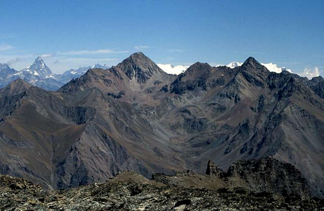
From Southwest
From Southwest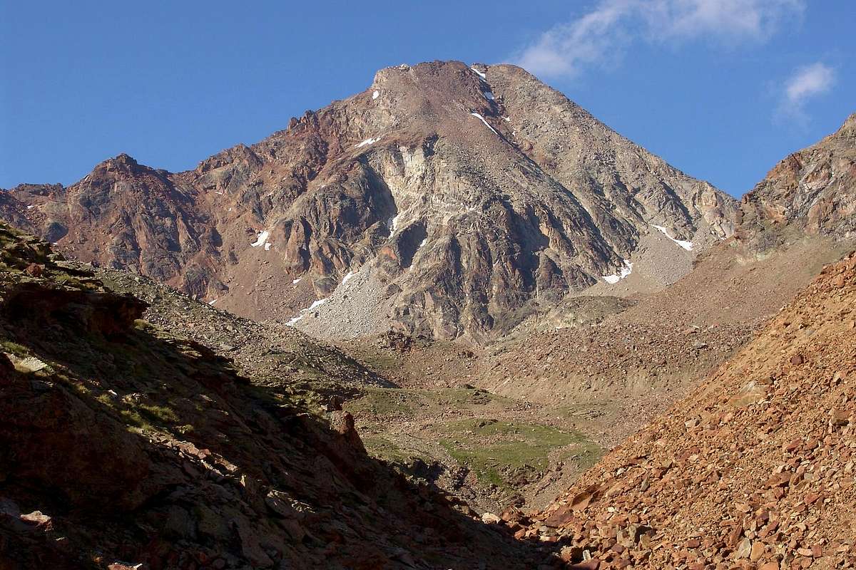 |
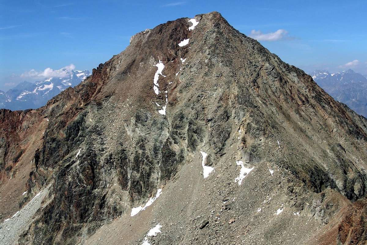
It includes all the ways that range from the South-southeast ridge or of the "Three Capuchin Crest" at the Southwest Ridge of Mont Ròss of Comboé, ie all the possible routes from the Walloon of Arbolle. This huge rock fans out from right to left with several rock outcrops are not always well identifiable, even to insiders. You could divide this broad Southern slope into three distinct areas:
a) - the right sector mostly facing South towards Punta Rossa and close to the Standard Route, with which it also shares the pproach;
a) - the right sector mostly facing South towards Punta Rossa and close to the Standard Route, with which it also shares the pproach;
 |
b) - a sector central or South-southwest, overlooking the Frozen Lake;
c) - a third part who is gradually going West-southwest and ends against the West Ridge, just beyond the small Collar to the East of the Little Emilius.
In fact, this side has a common front that unfolds in a radial pattern, the waters of which descend towards the South all Arbolle Vallon.
c) - a third part who is gradually going West-southwest and ends against the West Ridge, just beyond the small Collar to the East of the Little Emilius.
In fact, this side has a common front that unfolds in a radial pattern, the waters of which descend towards the South all Arbolle Vallon.
 |
Comprende tutte le vie che vanno dalla Cresta Sud-sudest o dei "Tre Cappuccini" alla Cresta Sudovest del Mont Ròss de Comboé, cioè tutti gli itinerari possibili dal Vallone di Arbolle. Questa vasta parete rocciosa si allarga a ventaglio dalla destra alla sinistra con diverse costole rocciose non sempre bene identificabili, anche agli addetti ai lavori. Si potrebbe suddividere tutto questo ampio Versante Meridionale in tre distinti settori:
a) - il settore di destra maggiormente rivolto a Sud verso la Punta Rossa e vicino alla Via Normale, con la quale condivide anche l'Approccio;
b) - un settore centrale o Sud-sudovest, che domina il Lago Gelato;
c) - un terzo che va progressivamente in direzione Ovest-sudovest e termina contro la Cresta Ovest, poco oltre il Colletto ad Est del Piccolo Emilius.
In realtà questo versante ha un fronte comune che si dispiega a raggiera, le acque del quale scendono tutte a Sud verso l'Arbolle.
 |
From the Summit (3.559m) through ascent Southeast Crest & descent with Variation 24ter on South Face into couloir under the same, by Osw
From West
From West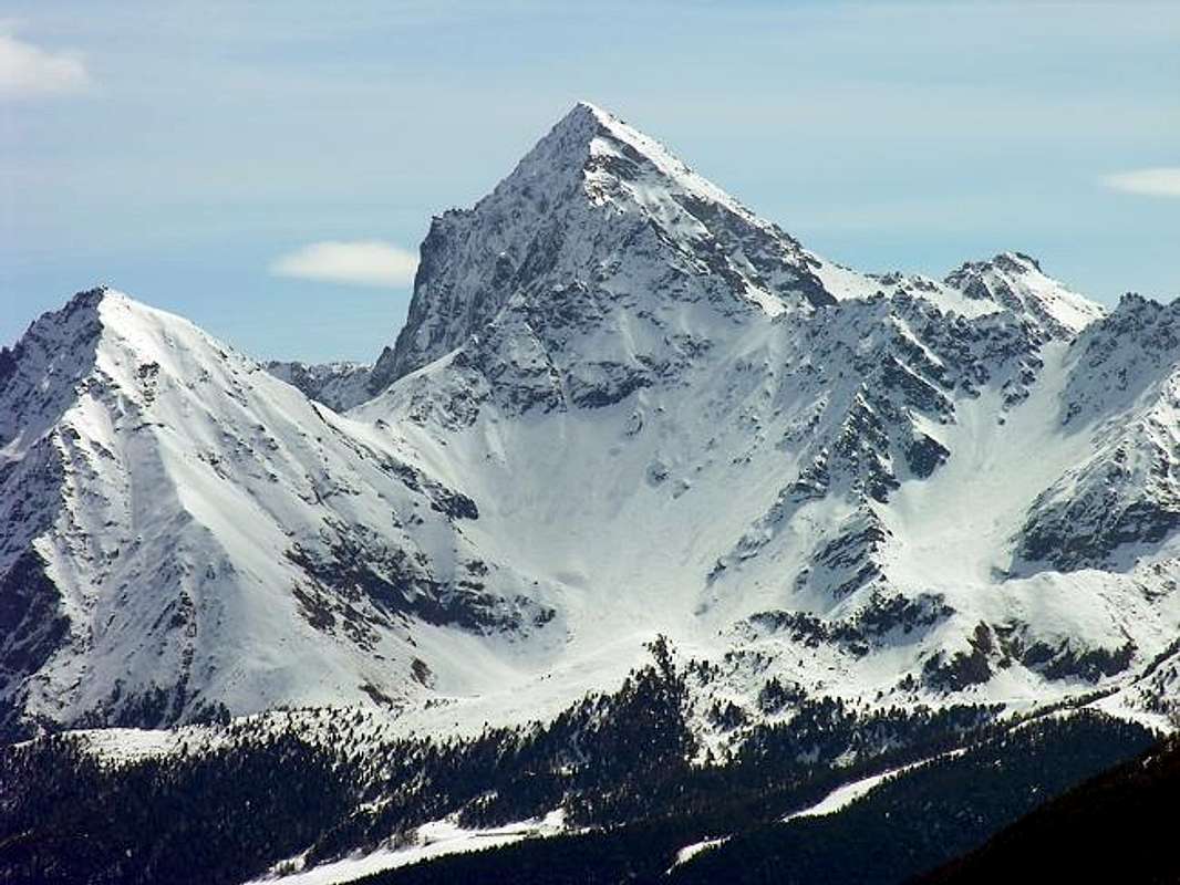 |
This sector includes a peculiarity, in fact, although part of the topography of Mount Emilius, is slightly secluded and detached from it. And perhaps this is the main reason for which has never gotten a lot of attention to her about it. It is in fact the long rocky spur that from the Mont Ròss of Comboé down towards the south-southwest and adapted to separate the Vallons of Comboé in the West Walloon of the long Arbolle.
The routes laid in 1974, 1996, 1999, and 2007 justify this jack of consideration, because all are grafted on the same buttress, forming possible point of departure towards the Peak of Emilius. The same, even though they were climbing as an end in themselves partially or in full, can in fact give rise to a complete ascent to the Summit.
The routes laid in 1974, 1996, 1999, and 2007 justify this jack of consideration, because all are grafted on the same buttress, forming possible point of departure towards the Peak of Emilius. The same, even though they were climbing as an end in themselves partially or in full, can in fact give rise to a complete ascent to the Summit.
 |
Almost an appeal to the most willing! Nevertheless, it should be said, explicitly, that these "Variants" are part of the wealth of experienced mountaineers of the place and looking for different solutions to reach the Top with new incentives. We must also admit to not expect great quality of the rock, which here is everywhere broken, fragile, insecure, and often covered with lichen if not, indeed, from grass mixed with potting soil.
The routes there are on this side and then with departures from Pila to the Walloons Arbolle or Comboé and are therefore a total of 6,2 of which are on the ridge, the first is to follow the long Buttress South-southwest, currently favored by the existence Refuge Arbolle (2.516m), near the homonymous lake. The second addressing the Carrel Hill (2.912m), near the Federigo Zullo Bivouac (2.907m), via the path with deviation right at the junction of Gros Scez (particular squared boulder) at an altitude of 2.500 meters.
The routes there are on this side and then with departures from Pila to the Walloons Arbolle or Comboé and are therefore a total of 6,2 of which are on the ridge, the first is to follow the long Buttress South-southwest, currently favored by the existence Refuge Arbolle (2.516m), near the homonymous lake. The second addressing the Carrel Hill (2.912m), near the Federigo Zullo Bivouac (2.907m), via the path with deviation right at the junction of Gros Scez (particular squared boulder) at an altitude of 2.500 meters.
* * * These are also reached by starting from the Regional Road to Reverier Dessous Alpages (1.042m), along the private dirt road that goes to Martsaouchy Damon, and the path to the Vallon of th'Arpisson Lower and Upper (2.010m), from this for the large moraine of the two glaciers, rising from "Sources of Emilius" at the base of the North Wall of the same, reaching the West Glacier trail and certainly more attractive but also more complicated and tiring.
So through the Northwest Ridge of Mount Ròss of Comboé, crossing the Little Emilius and West Ridge in the final part, the way that currently, since 2004, has been completely, too, equipped.
So through the Northwest Ridge of Mount Ròss of Comboé, crossing the Little Emilius and West Ridge in the final part, the way that currently, since 2004, has been completely, too, equipped.
 |
Routes from West, by Antonio
The other routes consist in outward diversified toward the Buttress South-southwest and are in number of 4:
a) - starting from the Grand Plan Alp (ruines) at the bottom and to the South of the Comboé Vallon, along the Crest Northwest of the SW Point of Trident Comboé (via open 07th October 2007 and traveled once);
b) - always from Grand Plan with the path diagonally to the North (to the East of the remains of Alpage signs), which reaches the Normal path of the "Becca" before Plan Valé Tableland, leaving him half way around in order to address on stony at the base of the great West-northwest Ridge of the Frozen Loch Points (3.115m) and climbing the same. Or with the path from Comboé to the entrance of the Plan of Valé and subsequent crossing through large blocks up to the base of the spur (route open June 16th, 2007 and crossed once);
c) - with the Normal path to "Becca" of 2.500 meters to the junction and subsequent ascent to the Ròss Pass steep debris flows and some ribs rotten stone, or, in the beginning of the season, steep snowfields (make sure that you have already dropped the avalanche, here always exists);
d) - to the West Face of Mount Ròss of Comboé, who has been climbed only once in June 1999, in which case the attack coincides with that of the hill until about halfway through, and then move progressively to the left towards the base wall near a rocky spur that "engages" in the scree. Of these 4 ways we gave a brief statement, since it had been almost completely taken into account in the "First Part", except that the climb to the Col Ross.
 |
Questo settore include una peculiarità, infatti, pur facendo parte della topografia del Monte Emilius, risulta leggermente appartato e distaccato dal medesimo. E forse é questo il principale motivo per il quale non ha mai ottenuto una grande attenzione al suo riguardo. Si tratta infatti di quel lungo contrafforte roccioso che a partire del Mont Ròss de Comboé scende in direzione Sud-sudovest ed atto a separare i Valloni del Comboé ad Occidente dal lungo Vallone di Arbolle.
 |
Le vie tracciate nel 1974, 1996, 1999 e 2007 giustificano questa presa di considerazione, perché tutte si innestano sullo stesso contrafforte, costituendo possibibili vie di partenza verso la Vetta dell'Emilius. Le medesime, pur essendo state salite come fine a se stesse parzialmente od in toto, possono infatti dare adito ad una salita completa fino alla Vetta. Quasi un appello rivolto ai più volenterosi! Ciononostante deve essere detto, in modo esplicito, che queste "Varianti" fanno parte del bagaglio di alpinisti esperti del luogo ed alla ricerca di soluzioni diverse per raggiungere la Vetta con nuovi stimoli. Inoltre bisogna ammettere di non aspettarsi grandi qualità della roccia, che qui é dappertutto rotta, fragile, insicura, nonché spesso ricoperta da lichene se non, addirittura, da erba mista a terriccio.
Le vie che si contano da questo lato, e quindi con partenze da Pila verso i Valloni di Arbolle e Comboé, sono dunque complessivamente 6, delle quali 2 in cresta; la prima consiste nel percorrere il lungo Contrafforte Sud-sudovest, attualmente favoriti dall'esistenza del Rifugio di Arbolle (2.516 m), presso l'omonimo lago. La seconda indirizzandosi al Colle Carrel (2.912 m) vicino al Bivacco Federigo Zullo (2.907 m) tramite il sentiero con deviazione a destra all'altezza del bivio di Gros Scez a quota 2.500 metri.
Le vie che si contano da questo lato, e quindi con partenze da Pila verso i Valloni di Arbolle e Comboé, sono dunque complessivamente 6, delle quali 2 in cresta; la prima consiste nel percorrere il lungo Contrafforte Sud-sudovest, attualmente favoriti dall'esistenza del Rifugio di Arbolle (2.516 m), presso l'omonimo lago. La seconda indirizzandosi al Colle Carrel (2.912 m) vicino al Bivacco Federigo Zullo (2.907 m) tramite il sentiero con deviazione a destra all'altezza del bivio di Gros Scez a quota 2.500 metri.
* * * Questi sono inoltre raggiungibili anche con partenza dalla Strada Regionale per Reverier Dessous (1.042 m), lungo la strada poderale che sale a Martsaouchy Damon, e con il sentiero per il Vallone dell'Arpisson Inferiore e Superiore (2.010 m); da questo per la grande morena dei due Ghiacciai, passando dalle "Sorgenti dell'Emilius" alla base della Parete Nord dello stesso, raggiungendo il Ghiacciaio Occidentale e con percorso sicuramente più suggestivo, ma anche maggiormente complicato e faticoso.
Quindi tramite la Cresta Nordovest del Mont Ròss de Comboé, traversata al Piccolo Emilius e Cresta Ovest nella parte finale, via che attualmente, dal 2004, é stata completamente, anche troppo, attrezzata.
 |
Le altre vie consistono in partenze diversificate verso il Contrafforte Sud-sudovest e sono in numero di 4:
a) - partendo da Grand Plan, in fondo ed a Sud del Vallone del Comboé, lungo la cresta Nordovest della Punta SW del Trident de Comboé (via aperta il 7 di Ottobre 2007 e percorsa un'unica volta);
b) - sempre da Grand Plan con il sentiero in diagonale verso Nord (segnalazioni ad Est delle rovine dell'Alpeggio), che raggiunge il sentiero della Normale alla "Becca" prima di Plan Valé, abbandonandolo a metà strada circa per indirizzarsi su pietraia alla base della grande Cresta Ovest-nordovest delle Punte del Lago Gelato (3.115 m) e scalandola. Oppure con il sentiero da Comboé fino all'imbocco del Plan di Valé e susseguente traversata tramite grossi blocchi fino alla base dello sperone (via percorsa per la prima ed unica volta il 16 di Giugno 1996);
c) - Con il sentiero della Normale fino al bivio 2.500 metri e successiva risalita al Col Ròss per ripide colate detritiche ed alcuni costoloni di roccia marcia, oppure, in inizio di stagione, ripidi nevai (far attenzione che sia già scesa la valanga, qui sempre esistente);
d) - per la Parete Ovest del Mont Ròss de Comboé, che é stata salita una sola volta nel Giugno 1999; in questo caso l'attacco coincide con quello del colle sin a circa metà percorso, per poi spostarsi progressivamente a sinistra verso la base della parete nei pressi d'una costola rocciosa "innestantesi" nella pietraia. Di queste 4 vie abbiamo dato un breve resoconto, poiché non eran state quasi del tutto prese in considerazione in "First Part", tranne che per la salita al Col Ròss.
 |
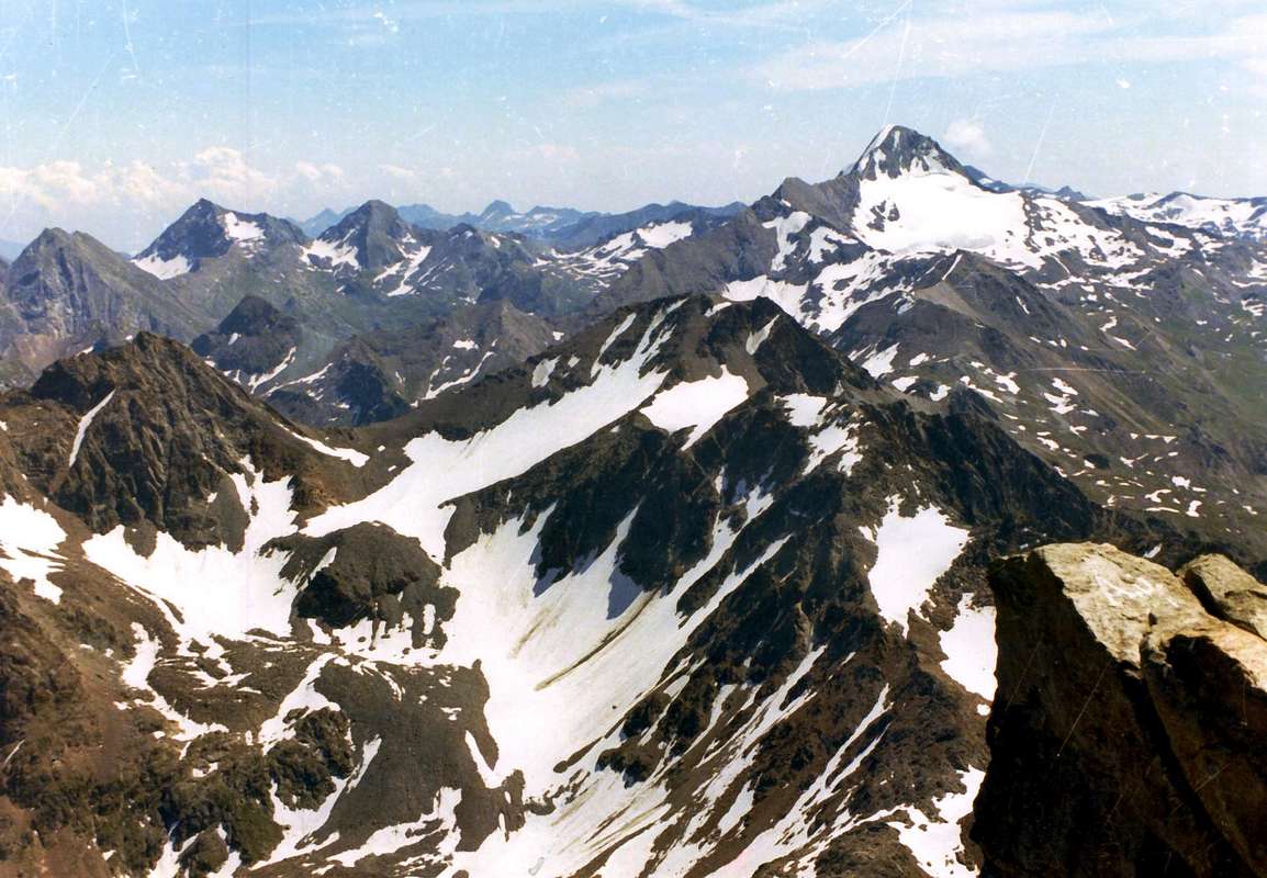
From North
From North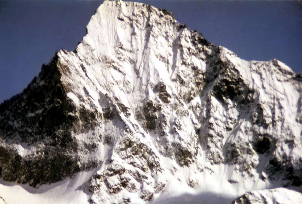 |
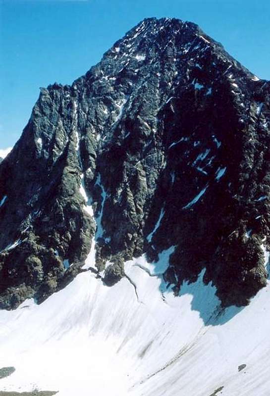
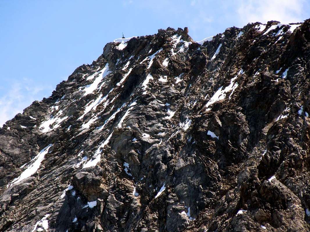
The large Northern Slope extends from the Carrel Hill to the Edge North-northeast for almost 2 km above the two Glaciers of Western and Eastern Arpisson, at the height of the homonymous and wild vallon, it certainly is the most striking part of the mountain, which dominates the City of Aosta here above 3.000 meters. Emilius is the postcard, business card for anyone who seen from below. Always.
 |
It is divided, although the front is unique, in different parts, for ease of explanation, so we divide: a sector below the Mont Ròss, a second similar underlying the Little Emilius, the North Wall with a "Mammellone" that out out to divide these two glaciers, a large forepart of more than 400 meters which is the Black Triangle and the dramatic and conclusive Edge North-northeast Arpisson the boundary between the Vallon and the Laures. On these routes were plotted with different difficulty levels, gradually increasing from West to East, where the wall becomes more precipitous and apparently impossible.
 |
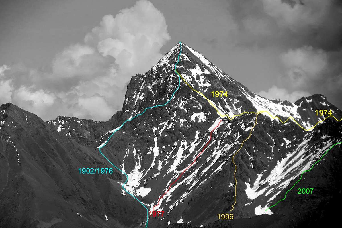
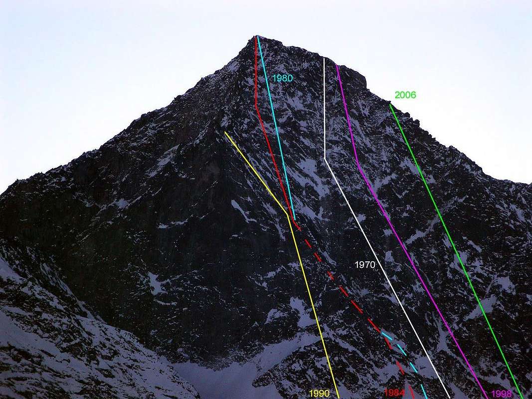
Black Triangle on North-northeast Edge, by Osw
In this case, instead of offering two focal points of view, it is preferred splittable tracing under the chronological aspect, taking into consideration the technical one. If in the previous "33 routes EMILIUS The MODERN MAGIC ERA Height Part" had leaked the story of ascents in the aspect of "Mentality" that climbs from the beginning until the mid-eighties and the new climbing, was arbitrarily identified since 1989 with the opening of the "Couloir Ghost", but here we divide the climbs purely from a technical point. The conquest of the Black Triangle Emilius in September 1960 by the roped Bozzetti-Rosset, reaches, for the first time, the classification of Via ED, that is Extremely Difficult, with several passages by the Scale U.I.A.A. of V° and VI°, for the first time in the entire Group of Monte Emilius, among them, and still the novelty, a passage of A1, namely Artificial 1. The number of routes traced on this side is quite high: a total of 16, in addition to West Ridge-northwest or right margin and, on the opposite side, the North-northeast Edge; 4 of these relate to the wide area that goes from the Pillar Right of way or Via Quendoz Trevisan September 1970 until the slopes of the Great Western Shoulder also called Mount Ròss of Comboé, 7 are typical of the central or "real" North Wall with also two-way direct, 2 are located on the "Mammellone" (also "Great Breast") or immediately to the side and finally 3 are addressed to the Black Triangle, of which the most recent or Via "Bocconi Amari-Senza Parole" by Libera-Marlier 2006 on the Northwest Face and two on the vertical North Wall "the real Black Triangle", as my friend and Mountain Guide Pietro "Piero" Rosset. After repeating in 1983 by three Guides Cogne, Aldo Cambiolo and Roberta Vittorangeli have a Direct on the same track in the Summer of '90.
 |
L'ampio Versante Settentrionale si allarga dal Colle Carrel allo Spigolo Nord-nordest per quasi 2 Km al di sopra dei due Ghiacciai Occidentale ed Orientale di Arpisson, al colmo dell'omonimo e selvaggio vallone, costituisce sicuramente la parte più appariscente della montagna, da qui dominante la Città d'Aosta dall'alto di 3.000 metri. Risulta la cartolina dell'Emilius, il biglietto da visita per chiunque l'osservi dabbasso. Da sempre. Si divide, anche se il fronte é unico, in diverse parti che, per facilità di spiegazione, così suddividiamo: un settore al di sotto del Mont Ròss, un secondo similare sottostante al Piccolo Emilius, la Parete Nord con un "Mammellone" che fuoresce a dividere i due ghiacciai suddetti, un grande avancorpo di oltre 400 metri costituente il Triangolo Nero ed il vertiginoso e conclusivo Spigolo Nord-nordest al limite tra l'Arpisson ed il Vallone delle Laures. Su questi sono state tracciate vie di svariata difficoltà, in graduale aumento da Ovest ad Est, ove la parete diventa più dirupata ed, apparentemente, impossibile.
 |
In questo caso, invece d'offrire due punti focali di vista, s'é preferito sdoppiarne la tracciatura sotto l'aspetto cronologico, tenendo in considerazione quello tecnico. Se nella precedente "33 routes EMILIUS's The MODERN MAGIC ERA Height Part" avevamo disgiunto la storia delle ascensioni sotto l'aspetto della "Mentalità", cioè ascensioni dall'inizio fino alla metà degli Anni Ottanta ed arrampicate della nuova Era, individuata arbitrariamente dal 1989 con l'apertura del "Couloir Fantasma", qui invece dividiamo le salite prettamente sotto l'aspetto tecnico. La conquista del Triangolo Nero dell'Emilius nel Settembre 1960, da parte della cordata Bozzetti-Rosset, raggiunge, per la prima volta, la classificazione di Via ED, cioé Estremamente Difficile, con diversi passaggi della Scala U.I.A.A. di V° e di VI°, per la prima volta nell'intero Gruppo del Monte Emilius, tra i quali, ed ancora la novità, un passaggio di A1, ovvero Artificiale 1. Il numero di vie tracciate su questo versante é alquanto elevato: un totale di 16, oltre alla Cresta Ovest-nordovest o margine di destra e, sul lato opposto, lo Spigolo Nord-nordest; di queste 4 riguardano quel largo settore dispiegato dal Pilastro di Destra o Via Quendoz-Trevisan 1970 fino alle pendici dello Spallone Occidentale o Mont Ròss de Comboé, 7 sono proprie del settore centrale o "vera" Parete Nord con anche due vie Dirette, 2 si trovano sul "Mammellone" o subito di lato ed infine 3 sono rivolte al Triangolo Nero, delle quali la più recente o Via "Bocconi Amari-Senza Parole" di Libera-Marlier 2006 sulla Faccia Nordovest e due sulla verticale Parete Nord "il vero Triangolo Nero", come dice il mio amico e Guida Pietro "Piero" Rosset. Dopo la ripetizione nel 1983 da parte di tre Guide di Cogne, Aldo Cambiolo e Roberta Vittorangeli hanno sul medesimo tracciato una Diretta nell'Estate del '90.
 |
North Wall details on upper part, by Antonio
From East
From East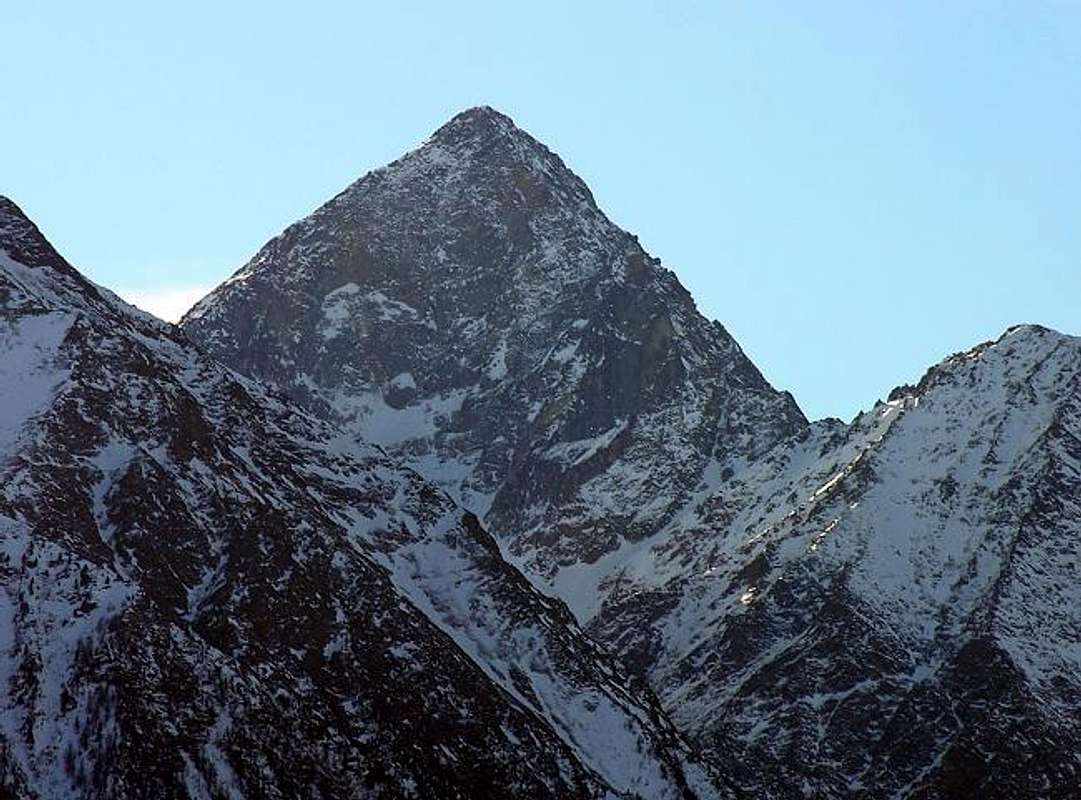 |
The Eastern Side is definitely the most picturesque and colorful. At the base of the vertical Wall East, limited by the North northeast Corner to the right and from East Crest on the opposite side, two beautiful lakes shine in emerald green: the Lac Dessous or Low nearby the Refuge Ernesto Ménabreaz at the Laures to the front of the wall and the Long Lake which is stretches from Northern to Southern at the base of the Mountain Chain of the three Roèses. This sector has three chances to climb, or on the two ridges and on the East Face, cited above. There are some variations on the same open after the first ascent of the famous rope Giusto Gervasutti-Renato Chabod in June 1935. In August of 1929 a terrible misfortune deprived of life two brothers of Aosta Town Jean and Alexander "Dino" Charrey with Cino Norat.
 |
They fell on the underlying Glacier Blantsette, when they lacked little to exit the Peak. The other two peaks are the result of exploration at the beginning of '900, Abbot Joseph Maria Henry with the great achievement in 1906 of the North northeast Edge known as "Crest of the Three Curates" four years earlier had descended and then climbed the East Ridge, also known as "Brissogne" together with the Guide of Charvensod Grégoire Comé.
The environment is graceful and idyllic setting, "troubled" only from the oppressive presence of the East Wall looming enthroned opposite.
The environment is graceful and idyllic setting, "troubled" only from the oppressive presence of the East Wall looming enthroned opposite.
 |
Il Versante Orientale é sicuramente il più pittoresco e colorato. Alla base della verticale Parete Est, limitata dallo Spigolo Nord-nordest a destra e dalla Cresta Est dal lato opposto, due bei laghi risplendono di verde smeraldo: il Lac Dessous presso il Rifugio Ernesto Ménabreaz alle Laures frontalmente alla parete ed il Lago Lungo che si distende da Nord a Sud alla base della Catena delle tre Roèses. Questo settore presenta tre possibilità di salita, ovvero sulle due creste e sulla Parete Est, già citata. Sulla medesima esistono alcune varianti aperte dopo la prima ascensione della famosa cordata Giusto Gervasutti-Renato Chabod nel Giugno del 1935.
 |
Nell'Agosto del 1929 una tremenda disgrazia privò della vita i due fratelli di Aosta Jean ed Alessandro "Dino" Charrey insieme a Cino Norat. Precipitarono sul sottostante Ghiacciaio Blantsette, quando mancava loro poco per uscire in Vetta. Le altre due creste sono frutto delle esplorazioni, all'inizio del '900, dell'Abbé Joseph Maria Henry con la bella conquista nel 1906 dello Spigolo Nord-nordest conosciuto come "Cresta dei Tre Curati"; quattro anni prima aveva disceso e poi risalito la Cresta Est, detta anche "di Brissogne" insieme alla Guida di Charvensod Grégoire Comé.
L'ambiente é leggiadro ed idilliaco, "turbato" soltanto dall'oppressiva presenza della Parete Est che incombe troneggiando dirimpetto.
L'ambiente é leggiadro ed idilliaco, "turbato" soltanto dall'oppressiva presenza della Parete Est che incombe troneggiando dirimpetto.
 |
Vallon through the path n°1 to Ménabreaz Refuge, by Antonio
From Southeast
From Southeast |
The last side is certainly less known to the mass, because it seems that the Emilius wants to hide behind the shoulders. In fact, beyond the Eastern Crest stands a Face Southeast perfectly triangular, not too steep, but it ends with a vertical wall that the band at the base, just above the small Frozen Lake. Just below this last a lake far larger, the Dessus, also known as Lac de "Dzacquin", is wedged between smooth rocks below the Peak of the "Three Capuchins", located between the eponymous Pass and the Arbolle Hill. Here the head of the Walloon of the Laures opens shaped like a large leaf, limited, from East to West, from the Summit of the Eastern Red Point and the ridge dividing the Vallon of Grauson-Lussert in Cogne Valley, after the Point of Laures , shape and homonyms Hill and Mount. So be directed to the East and to the Tops of Lussert and Leppe; to East the Point Ilario Antonio Garzotto and the Great Roise close to this magnificent and great surroundings. But back to our side to remember to add that its left edge coincides with the Crest of the "Three Cappuccini", or Normal for Emilius. Standard Route is coming from the Vallon of Arbolle and from that of Laures, though often, especially when the pitch is still has a lot of snow or ice, the mountaineers of the Grand Brissogne prefer climbing the East Crest, their crest, although slightly more challenging.
 |
We spoke of this area unknown to the masses, but certainly not to Mountaineers, Hunters and local Shepherds.
Again, these are three climbing routes: the two ridges and the Southeast Face.
Again, these are three climbing routes: the two ridges and the Southeast Face.
 |
L'ultimo versante é quello sicuramente meno conosciuto dalla massa, anche perché sembra quasi che l'Emilius voglia nasconderlo dietro le su spalle. Infatti al di là della cresta Est si eleva un Versante Sudest perfettamente triangolare, non eccessivamente ripido, che però termina con un muro verticale che lo fascia alla base, appena sopra al piccolo Lago Ghiacciato.
 |
Appena sotto questo ultimo un lago ben più grande, il Dessus, detto anche Lac de "Dzacquin", si incunea tra rocce levigate al di sotto della Punta dei "Tre Cappuccini", posta tra l'omonimo Passo ed il Colle di Arbolle. Qui la testa del Vallone delle Laures si apre a forma di grande foglia; limitato, da Est ad Ovest, dalla Sommità Orientale della Punta Rossa e dalla cresta spartiacque con il Vallone del Grauson-Lussert in Valle di Cogne che, dopo la Punta des Laures, forma omonimi Colle e Mont. Quindi si indirizza ad Est verso le Punte di Lussert e Leppe; la Punta Ilario Antonio Garzotto e la Grande Roise chiudono ad Est questo magnifico e grande circondario. Ma tornando al nostro versante c'é da aggiungere che il suo bordo di sinistra coincide con la Cresta dei "Tre Cappuccini", o Normale per l'Emilius. Via Normale sia arrivando dal Vallone di Arbolle che da quello delle Laures, anche se spesso, soprattutto quando il Passo presenta ancora molta neve oppure é ghiacciato, i montanari di Grand Brissogne gli preferiscono la salita sulla Cresta Est, la loro cresta, anche se leggermente più impegnativa.
Dicevamo di questo settore sconosciuto alla massa, ma non di certo ad Alpinisti, Cacciatori e Pastori locali.
Anche qui le vie di salita sono tre: le due creste e la Faccia Sudest.
Dicevamo di questo settore sconosciuto alla massa, ma non di certo ad Alpinisti, Cacciatori e Pastori locali.
Anche qui le vie di salita sono tre: le due creste e la Faccia Sudest.
 |
- Meteo: you can find all the needed informations at the official site of the Valle d'Aosta Region:
- Valle d'Aosta Meteo
Books and Maps
- "Guida del Monte Emilius", di Osvaldo Cardellina Editore in collaborazione con il Club Alpino Italiano Sezione di Aosta, Dicembre 1978.
- "Guida dei Monti d'Italia – Emilius Rosa dei Banchi Parco del Mont Avic" di Giulio Berutto e Lino Fornelli - Club Alpino Italiano/Touring Club Italiano, Marzo 2005.
- "Guida delle Alpi Occidentali" di Giovanni Bobba e Luigi Vaccarone C.A.I. Sezione di Torino Volume II (parte II), 25 Maggio 1896.
- "80 itinerari di Escursionismo Alpinismo e Sci Alpinismo in Valle d'Aosta", di Osvaldo Cardellina, Ed. Musumeci, Giugno 1977 (in Italian); seconda Ed. Luglio 1981; terza Ed. Luglio 1984; (in French), prima Ed. Febbraio 1978; seconda Ed. Marzo 1980.
- "Diari Alpinistici" di Osvaldo Cardellina e Indice Generale accompagnato da Schedario Relazioni Ascensioni 1964-2019 (inediti).
 |
 |
 |
- Kompass "Gran Paradiso Valle d'Aosta Sentieri e Rifugi" Carta turistica 1:50.000.
- L'Escursionista "Conca di Aosta-Pila-Monte Emilius" Carta dei sentieri (n° 4) 1:25.000.
- Hapax "Les Sentiers Comunità Montana Monte Emilius", Luglio 2000 1:25.000.
- Enrico Editore Ivrea-Aosta "Gruppo del Gran Paradiso" 1:50.000.
- I.G.C. Istituto Geografico Centrale, Torino "Carta delle Passeggiate ed Escursioni in V.D.A. Conca di Pila-Gressan, 1:20.000.
External Links
- More about Emilius Another description with 40 shots, 6 panoramas and a "handmade" map, about Emilius.
- Pila web-site Pila, the famous winter station, has an active life even in summertime. In this link, you'll able to find time schedule for Chamolè Chair Lift.
- REGIONE AUTONOMA VALLE D'AOSTA the official site.
- FONDAZIONE MONTAGNA SICURA Villa Cameron, località Villard de la Palud n° 1 Courmayeur (AO) Tel: 39 0165 897602 - Fax: 39 0165 897647.
- A.I.NE.VA. (Associazione Interregionale Neve e Valanghe).
Useful numbers
- Protezione Civile Valdostana località Aeroporto n° 7/A Saint Christophe (Ao) Tel. 0165-238222.
- Bollettino Valanghe Tel. 0165-776300.
- Bollettino Meteo Tel. 0165-44113.
- Unità Operativa di Soccorso Sanitario Tel. 118.