


-
 7397 Hits
-
 81.84% Score
-
 14 Votes
|
|
Route |
|---|---|
|
|
45.67899°N / 7.38455°E |
|
|
Summer |
|
|
A long day |
|
|
From Tourist to Mountaineering up to IV°- |
|
|
Class 3 |
|
|
II |
|
|
|
La montagna chiama i suoi figli, ed essi rispondono fedelmente al suo appello… Osvaldo Cardellina, Diario alpinistico, 1964-65 Page texts: @ OsvaldoCardellina "Osva", passed away on May 2, 2022. Page owners: Christian Cardellina e Osvaldo Cardellina. Any updates from September 12, 2022: Antonio Giani, page administrator, friend and climbing companion. Testi della pagina: @ OsvaldoCardellina "Osva", scomparso il 2 maggio 2022. Proprietari pagina: Christian Cardellina e Osvaldo Cardellina. Eventuali aggiornamenti dal 12 settembre 2022: Antonio Giani, amministratore della pagina, amico e compagno di salite. |
Classic Emilius's Group Overview
Punta Valletta , the Punta Garin and the Mountain Chain of Roèses, understood in a narrow sense, ie considering the distinct topographic demarcations. In any case, this analysis stops at the Saint Marcel Hill also called Col of Coronas, net divider between these mountains and those belonging to Group of Tersiva (3.515m) and then covering other Walloons: Grauson with branch Doreire or Tessonet, Urtier, Champorcher-Pontonnet, Fénis-Clavalité and Saint-Marcel, this latest in the field to the East of its Torrent. In our case, however, are considered and visited the Walloons, always starting from West to East, the following: the lower part of the Cogne Valley (to North respect the Grand Eyvia), the Vallon Arpisson's, Vallon of Grauson with ramification to Lussert. This is to the South, while, on the North we have: Pila Basin, the, following, Vallons Dard-Comboé-Arbolle, of th'Arpisson Vallon, Walloons of Laures and St. Marcel, to partition the eponymous Torrent.
With this discussion we think we have "covered" more than 90% chance of climb on the ridges of Emilius and surroundings; still remain small crossings that eventually turn out to be of the variants, more or less important than total exposed. Because we do not have the palate of some insignificant or dangerous to the nature of the soil, than others because it is already given statements in SP (see "Crestone" N-NE of the Nona's Becca) because of other ridges with an end unto themselves. Or, and finally, because it was no detailed remarks and informations (for ex. the ridge that rises from the Col Garin Mount Valaisan, crossed only once in the late Forties by Toni Ortelli and Nando Quagliolo and perhaps subsequently repeated by Vincenzo Guide Cogne "Cenzi" Perruchon, to join the Normal Route of Peak Garin) and others, such as the Northeast "Crestone" Little Roise, via on only three occasions with two different routes during the months of August/September/October 1998. Or Spur Northeast Great Roise with ascent of 24 June 1921 by Jean D'Entrèves with the famous Mountain of Valtournanche Guide Luigi Carrel, called the "Carrellino", this last way repeated by Sergio Pession and Piero Pieiller August 18th, 1983, with variations to right (North), it is difficult and dangerous is a little a climb in itself, rather than a crossing, even though, to go down, a part of the ridge had to do it at least until the notch (in August 4th, 1985 with Giuseppe "Peppino" Lamazzi found ourselves just below the Summit his binoculars Russian hunter. Gave it to me when I told it to him!). These and other amenities will be narrated in what it is not and will not be a dry exhibition of routes and itineraries, but something alive and lived. part of all Protagonists and in Time. "The Emilius's Long Time". In any case, for the curious and the "perfectionists", we will propose a fun panneau which will be listed in the "What does not exist and where you get it". You will find and discover all the ridges and edges that have not been included in these 10 Great Crossings Group of Monte Emilius. But all and if there is someone you have missed apologize, perfection is not everything in this world. Some crossings such as the one that goes from the Grauson Tower to Garin and those with Spur South or East Ridge lead to the Point of the Laures, then to reach successively the three Red Tops, Mount Valaisan and finally the Peak Garin, they would definitely deserved better fate and location if only for the development of their long journeys, but we have, perhaps unfairly, as assessed variants of the crossing of the base.
With regard to the technical evaluations for the overall difficulty or the individual passages in the rock, please refer to "Parts First & Third of 33 ROUTES," and were inserted intermediate times, and final, slightly dilated, for the avoidance of unfavorable conditions or, more simply turn in a precautionary to the unpredictable weather to bad.
*******
SUMMIT of the SUMMITS 1977
******* Questa "Sesta Parte" del lavoro é dedicata alle Grandi Traversate effettuabili nel Gruppo del Monte Emilius e quindi nei viciniori, ancor più piccoli, ma ben distinti, Gruppi della Punta Valletta, della Punta Garin e della Catena delle Roèses, intesi in senso ristretto, ovvero considerando le distinte demarcazioni topografiche. In ogni caso quest'analisi s'arresta al Colle di St. Marcel od anche detto di Coronas, netto divisorio tra queste montagne e quelle appartenenti al Gruppo della Tersiva (3.515 m) e quindi concernenti altri Valloni: Grauson con ramo Orientale di Doreire o del Tessonet, Urtier, Champorcher-Pontonnet, Fénis-Clavalité e St. Marcel, quest'ultimo nel settore ad Est del suo Torrent. Nel nostro caso, invece, vengon considerati e visitati i Valloni, partendo sempre da Ovest verso Est, di: parte inferiore della Val di Cogne (a Nord della Grand'Eyvia), Vallone di Arpisson, Vallone del Grauson con ramo di Lussert o Centro-Occidentale. Questo per la parte Meridionale dell'intera area, mentre per quanto riguarda quella Settentrionale avremo: Conca di Pila, Valloni, in successione, del Dard-Comboé-Arbolle, Vallone dell'Arpisson, Vallone delle Laures e Vallone di St. Marcel, fino al divisorio dell'omonimo Torrent.
Con questa disamina pensiamo d'aver "coperto" oltre il 90% delle possibilità di salita sulle creste dell'Emilius e dintorni; rimangon ancor piccole traversate alla fin fine risultanti essere delle varianti, più o meno importanti, di quanto complessivamente esposto, Di alcune non abbiamo parlato perché insignificanti o pericolose per la natura del terreno, di altre perché se n'é di già dato rendiconto in SP (vedi il "Crestone N-NE della "Becca"); di altre perché creste con fine a sè stesse. Oppure, e per finire, perché non si avevano dettagliati ragguagli (ad esempio la cresta che dal Col Garin sale al Mont Valaisan, percorsa un'unica volta sul finire degli Anni Quaranta da Toni Ortelli e Nando Quagliolo e forse successivamente ripetuta dalla Guida di Cogne Vincenzo "Cenzi" Perruchon, la quale va poi ad unirsi alla Via Normale della Garin) e d'altre ancora, come il Crestone Nordest della Petite Roise, percorso in tre sole occasioni tramite due vie diverse nei mesi di Agosto/Settembre/Ottobre 1998. Oppure lo Sperone Nordest della Grande Roise salito il 24 Giugno 1921 da Jean D'Entrèves con la famosa Guida di Valtournanche Luigi Carrel, detto il "Carrellino"; quest'ultima via ripetuta da Sergio Pession e Piero Pieiller il 18 Agosto 1983, con varianti sulla destra, é difficile e pericolosa e costituisce un poco una salita a sé stante, piuttosto che non una traversata, anche seppoi, per scendere, un tratto di cresta dovettero farlo almeno sin all'intaglio (nel 1985 con Giuseppe "Peppino" Lamazzi ritrovammo poco sotto la Vetta il suo binocolo russo da cacciatore. Me lo regalò, quando glielo raccontai!). Queste ed altre amenità saranno narrate in quella che non é e non vuol essere un'arida esposizione di vie e tracciati, bensì un qualcosa di vivo e vissuto. Da parte di tutti i Protagonisti e nel Tempo. il "Il Lungo Tempo dell'Emilius". In ogni caso, per i più curiosi ed i "perfezionisti", vi proporremo un divertente panneau nel quale sarà elencato "Ciò che non c'é e dove lo troverete". Scoprirete tutte le creste o gli spigoli, non compresi in queste 10 Grandi Traversate nel Gruppo dell'Emilius. Ma proprio tutti e se qualcuno c'é sfuggito abbiatene venia, la perfezione non è cosa di questo mondo. Alcune traversate come quella che sale dalla Tour Grauson alla Garin e quelle che con lo Sperone Sud o la Cresta Est portano alla Punta des Laures, per raggiungere successivamente in progressione le tre Punte Rosse, il Mont Valaisan ed infine il Pic Garin, avrebbero sicuramente meritato miglior sorte se non altro per lo sviluppo dei loro lunghi percorsi, ma le abbiamo, forse ingiustamente, valutate come varianti della traversata di base.
Per quanto concerne le valutazioni tecniche per le difficoltà complessive od i singoli passaggi in roccia si rimanda alle "Parti Prima e Terza di 33 ROUTES", mentre son stati inseriti i tempi intermedi e finali, leggermente dilatati, a scanso di condizioni sfavorevoli o, più semplicemente e precauzionalmente, per il volgere imprevedibile del tempo al brutto.ROIZA's Mountain Chain in Emilius Group, by emilius.
The GREAT TRAVERSES (10)
With this discussion we think we have "covered" more than 90% chance of climb on the ridges of Emilius and surroundings; still remain small crossings that eventually turn out to be of the variants, more or less important than total exposed. Because we do not have the palate of some insignificant or dangerous to the nature of the soil, than others because it is already given statements in SP (see "Crestone" N-NE of the Nona's Becca) because of other ridges with an end unto themselves. Or, and finally, because it was no detailed remarks and informations (for ex. the ridge that rises from the Col Garin Mount Valaisan, crossed only once in the late Forties by Toni Ortelli and Nando Quagliolo and perhaps subsequently repeated by Vincenzo Guide Cogne "Cenzi" Perruchon, to join the Normal Route of Peak Garin) and others, such as the Northeast "Crestone" Little Roise, via on only three occasions with two different routes during the months of August/September/October 1998. Or Spur Northeast Great Roise with ascent of 24 June 1921 by Jean D'Entrèves with the famous Mountain of Valtournanche Guide Luigi Carrel, called the "Carrellino", this last way repeated by Sergio Pession and Piero Pieiller August 18th, 1983, with variations to right (North), it is difficult and dangerous is a little a climb in itself, rather than a crossing, even though, to go down, a part of the ridge had to do it at least until the notch (in August 4th, 1985 with Giuseppe "Peppino" Lamazzi found ourselves just below the Summit his binoculars Russian hunter. Gave it to me when I told it to him!). These and other amenities will be narrated in what it is not and will not be a dry exhibition of routes and itineraries, but something alive and lived. part of all Protagonists and in Time. "The Emilius's Long Time". In any case, for the curious and the "perfectionists", we will propose a fun panneau which will be listed in the "What does not exist and where you get it". You will find and discover all the ridges and edges that have not been included in these 10 Great Crossings Group of Monte Emilius. But all and if there is someone you have missed apologize, perfection is not everything in this world. Some crossings such as the one that goes from the Grauson Tower to Garin and those with Spur South or East Ridge lead to the Point of the Laures, then to reach successively the three Red Tops, Mount Valaisan and finally the Peak Garin, they would definitely deserved better fate and location if only for the development of their long journeys, but we have, perhaps unfairly, as assessed variants of the crossing of the base.
With regard to the technical evaluations for the overall difficulty or the individual passages in the rock, please refer to "Parts First & Third of 33 ROUTES," and were inserted intermediate times, and final, slightly dilated, for the avoidance of unfavorable conditions or, more simply turn in a precautionary to the unpredictable weather to bad.
SUMMIT of the SUMMITS 1977
 |
Con questa disamina pensiamo d'aver "coperto" oltre il 90% delle possibilità di salita sulle creste dell'Emilius e dintorni; rimangon ancor piccole traversate alla fin fine risultanti essere delle varianti, più o meno importanti, di quanto complessivamente esposto, Di alcune non abbiamo parlato perché insignificanti o pericolose per la natura del terreno, di altre perché se n'é di già dato rendiconto in SP (vedi il "Crestone N-NE della "Becca"); di altre perché creste con fine a sè stesse. Oppure, e per finire, perché non si avevano dettagliati ragguagli (ad esempio la cresta che dal Col Garin sale al Mont Valaisan, percorsa un'unica volta sul finire degli Anni Quaranta da Toni Ortelli e Nando Quagliolo e forse successivamente ripetuta dalla Guida di Cogne Vincenzo "Cenzi" Perruchon, la quale va poi ad unirsi alla Via Normale della Garin) e d'altre ancora, come il Crestone Nordest della Petite Roise, percorso in tre sole occasioni tramite due vie diverse nei mesi di Agosto/Settembre/Ottobre 1998. Oppure lo Sperone Nordest della Grande Roise salito il 24 Giugno 1921 da Jean D'Entrèves con la famosa Guida di Valtournanche Luigi Carrel, detto il "Carrellino"; quest'ultima via ripetuta da Sergio Pession e Piero Pieiller il 18 Agosto 1983, con varianti sulla destra, é difficile e pericolosa e costituisce un poco una salita a sé stante, piuttosto che non una traversata, anche seppoi, per scendere, un tratto di cresta dovettero farlo almeno sin all'intaglio (nel 1985 con Giuseppe "Peppino" Lamazzi ritrovammo poco sotto la Vetta il suo binocolo russo da cacciatore. Me lo regalò, quando glielo raccontai!). Queste ed altre amenità saranno narrate in quella che non é e non vuol essere un'arida esposizione di vie e tracciati, bensì un qualcosa di vivo e vissuto. Da parte di tutti i Protagonisti e nel Tempo. il "Il Lungo Tempo dell'Emilius". In ogni caso, per i più curiosi ed i "perfezionisti", vi proporremo un divertente panneau nel quale sarà elencato "Ciò che non c'é e dove lo troverete". Scoprirete tutte le creste o gli spigoli, non compresi in queste 10 Grandi Traversate nel Gruppo dell'Emilius. Ma proprio tutti e se qualcuno c'é sfuggito abbiatene venia, la perfezione non è cosa di questo mondo. Alcune traversate come quella che sale dalla Tour Grauson alla Garin e quelle che con lo Sperone Sud o la Cresta Est portano alla Punta des Laures, per raggiungere successivamente in progressione le tre Punte Rosse, il Mont Valaisan ed infine il Pic Garin, avrebbero sicuramente meritato miglior sorte se non altro per lo sviluppo dei loro lunghi percorsi, ma le abbiamo, forse ingiustamente, valutate come varianti della traversata di base.
Per quanto concerne le valutazioni tecniche per le difficoltà complessive od i singoli passaggi in roccia si rimanda alle "Parti Prima e Terza di 33 ROUTES", mentre son stati inseriti i tempi intermedi e finali, leggermente dilatati, a scanso di condizioni sfavorevoli o, più semplicemente e precauzionalmente, per il volgere imprevedibile del tempo al brutto.
 |
In this section we offer 10 crossings in the entire Group of Emilius, intended to Saint Marcel Hill or Corona(s), and from this stems the other neighbor Group of Tersiva (3.515m), both part of the so-called Graian Alps of the Southeast.
In choosing this compilation is made the decision to offer something for everyone: for experienced climbers, mountaineers, "alpinucci" (= small & bad alpine mountaineers!),as my friend says when he meets Gigi Reverchon written smear and slander the Books of Peak leaving them with an adequate response, hikers, and why not, also to tourists, For the thing which the first 8 crossings are addressed to the first, the ninth hikers (but they can also take advantage by doing the first parts in these Routes, which are much hiking), while 'last crossing is aimed at peaceful tourists with good will to make a pleasant "with a high and strong legs", even in the company of childrens, so they can make contact with the area, visiting also some "sacred relic." Which is not too bad!
In describing these 10 Crossings of Emilius, we will give you even at the bottom of each mini a historical note, that make us participate, at least virtually, to the facts and events of the TIME ...*******
*******
In questa sezione proponiamo 10 traversate nell'intero Gruppo dell'Emilius, inteso fino al Colle di Saint Marcel o di Corona(s); da questo prende origine l'altro viciniore Gruppo della Tersiva (3.515 m), entrambi facenti parte delle cosiddette Alpi Graie di Sudest.
Nello scegliere questa compilazione s'é effettuata la decisione d'offrire a tutti qualcosa: ad alpinisti esperti, alpinisti, "alpinucci", come dice il mio amico Gigi Reverchon quand'incontra scritte che imbrattano ed offendono i Libri di Vetta, lasciando loro un'adeguata risposta, escursionisti e, perché no, anche ai turisti, Per la quale cosa le prime 8 traversate sono rivolte ai primi, la nona agli escursionisti (ma questi posson anche approfittar effettuando le prime parti in queste Routes, che sono decisamente escursionistiche), mentre l'ultima traversata é rivolta a tranquilli turisti con buona volontà d'effettuar una piacevole irrobustente sgambata, anche in compagnia di bambini, che posson così prendere contatto con la zona, visitando anche qualche "sacra reliquia". Il che non é poi così male!
Nel descrivere queste 10 Traversate dell'Emilius, vi daremo anche in calce ad ognuna una mini nota storica, tale da farci partecipare, almeno virtualmente, ai fatti ed agli eventi dell'EPOCA ...
*******
EMILIUS's ALL GREAT CROSSINGS FIRST and REPLAY KNOWABLE & UNKNOWN
From West to East Topographical Areas
A) - Wide Tour of the Pila Basin (Points de la Pierre, Drinc, Couiss, Grevon, Monpers, Tsa Setze, Valletta/Mount Belleface/Testa Nera/Dard).
B) - Jagged South-southwest Buttress of Mount Emilius (Comboé Trident,Frozen Loch Points, Pass & Mount Ròss of Comboé).
C) - Classic Traverse Becca of Nona/ Mount Ròss of Comboé/Little Emilius/Mount Emilius (Actually "Via Ferrata", since 2004).
D) - Wild Crossing Mount Père Laurent/ Points & Becca of Seneva/Peckoz Pass/Testa Blantsette & Carving/Black Triangle/Emilius.
E) - Oceanic Traverse Peak Garin/Mount Vallaisan & Pass/Emilius Three Red Points/Arbolle Hill/Point of Three Capuchins & Pass/Emilius.
F) - Indented South-southwest Buttress of Garin Peak (Points of Arpisson & Coupées of Arpisson/Arpisson's Tower/Point Fleurie/Lavà's Tops/Garin).
G) - Solitary crossing Laures Pass/Hill of Saint Marcel or Coronas through Lussert's-Leppe's Points & Vallonet's Pass & Mount.
H) - Fascinating Traverse Salé Becca & Pass/Little-Central (Junod Points)-Great Roises/Punta Ilario Antonio Garzotto/Leppe Hill.
I) - Exploratory Crossing Martsaouchy Alpages/Arpisson Walloon/Sources of Emilius/Carrel Hill (Federigo Zullo Bivouac)/Plan Valé/Comboé Walloon/Pila Res.
L) - Mystical Walking Reverier Dessous/Saint Joseph Chapel/Ponteilles Waterfall/Comboé Canons Shelter/Plan Fenetre Hill with Cross/St. Grat Hermitage/Pila Old & New Churc. Various Variants in descent to Aosta City or Pollein Municipality at the State Road n°26 or Motorway A5.
******* Summary of the pathways, assessment of overall difficulty (U.I.A.A. Scale), reporting special passages or required. Intermediate and final journey times (altogether ascent & descent).
LEGENDA
T = for Tourists;
E = for Hikers;
EE = for Expert Hikers;
EE/A = for Expert Hikers & Mountaineers;
A = for Mountaineers;
AExp. = for Expert Mountaineers.
******* Rocky Passages:
I° = Easy; altogether = F+;
II° = Not much Difficult; in all = from PD- to PD+;
III° = Enough Difficult; all in all = from AD- to AD+;
IV° = Difficult; totally from D- to D+.
******* Intermediate times and total
h = Hours;
' = minutes
Examples. : 1h'30 = one hour and thirty minutes;
1h'30/4h'00 = 1h'30 partial time; 4h'00 = completely.
IMPORTANT REMARK
The first time reported is a partial, the second a partial sequence that adds to the previous, or a total time final excursion.
******* A) - Tour of the Pila's Basin: from Pila Resort
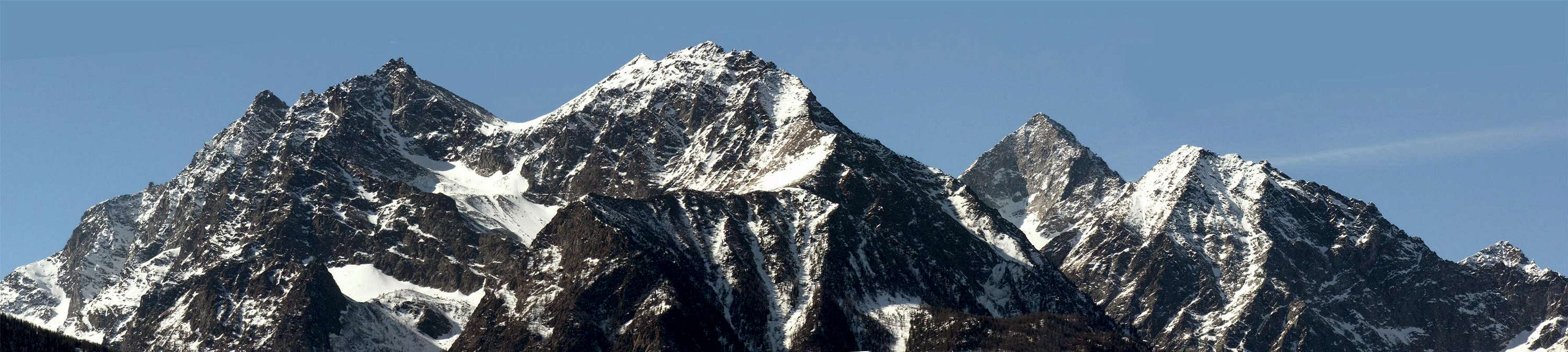
The ridge from Point of the Valletta (3.090m) to Testa Nera (2.819/20m).
*******
Pila Resort/Grimondet Alp/Points de la Pierre Hill and Point/Drinc(k) Point and Pass/Couiss Point, with Arno Shelter (3h'00/3h'30)/Grevon Plate/ Monpers Point/Tsa Setze Point & Hill, Point of the Valletta/Mount Belleface/Testa Nera/Chamolé's Hill & Coastline/Replan Southern Hill, Point & Northern/Signal Sismonda/Plan of Fenetre Hill/Point of Ponteilles/Valletta Point W-SW Crest (EEA; 5h'00/5h'30). Point of Dard with descent to Saint Grat Hermitage or to Pila Resort (EE; F; 5h'00/6h'00).
The route, by GPS, from Point of Ponteilles (2.263m) & Signal Sismonda (2.343m) to Replan's Point & Hills (2.366m, 2.457m, 2.447m).
******* Historical FEATURES
and the first of Cogne between the Walloons of the Plan de l'Eyve/Comboé in the next section that descends from the Punta della Valletta (3.089/90m), the highest elevation of this as small as extensively vast mountainous subgroup, you lose, even mountaineering speaking, the Night of Time. A third area, lower and facing North, divides the Pila Basin from that of Dard, paradoxically, it is the most and the least attended. It starts from the Col de Plan Fenetre (2.229m) major point of transit for the entire Group of Emilius, at least until the opening of the Refuge Arbolle, but proceeds to the North with a ridge that slopes forming Points of Ponteilles, Valletta and Dard (2.033m), also called "Pointe du Rem", that of copper, which precipitates wooded and rocky Alp of Pousses or Pouces in Charvensod Commune. This last section is almost entirely unfrequented on the ridge and down a small path, sometimes covered by vegetation, drawn more by the Forest Service, to mark the particles of the forest, not by the passage of walkers. However, it was already inhabited in the past, so that was used by the local and famous Guide "with mule" Grégoire Comé to accompany Comboé, going from a small wooden walloon in the North that leads to Point Valletta (2.164m), up to 19 December 1889 the party Emilio Alessandro Martelli, Silvio Miglietti with the Valtournanche's Mountain Guide Jean Baptiste Aymonod and duplicated the next day made the first winter ascent of the Becca di Nona, while Grégoire returned, the same route, in Charvensod.
The other six sections, so we called and divided, are formed from these sections of the ridge:
4) - This stretch is short but twofold, in that it offers two possibilities:
5) - Taking up the watershed ridge you can take the rocky grassy Costa Chamolé's Coastline (2.580m, 2.509m), is a dangerous route to the presence of large sections of grass on the rocks and ends with a short, but steep, rock step before the two Hills and the Point Replan. Preferably to be avoided, it can serve only in winter climbing from the East shore of Lake Chamolé (2.325m) to avoid, in the presence of dangerous snow, the slope below the eponymous hill. Cross it only if you really want to make the Lap of Pila Basin.
6) - Contrary to the previous section of the ridge is a very useful and very popular for the passage in the beautiful Walloon of Comboé at the foot of Becca and Emilius. After an initial Replan Hill, less used and steepest descent in the East, the same name and the subsequent small Point (scenic wooden bench between the two) opens the Hill of Northern Replan (2.366m), a real door in the crossing from the lake in this small walloon. Over the ridge continues with a beautiful path, bypassing some roughness immediately to the West, reaches an altitude secondary and then the Signal Sismonda, dedicated to a great Naturalist and Scientist, on which the ruins still Rimage perimeter of the Astronomical Observatory erected for him and dedicated to him by his friend Georges Canon Carrel (2.343m). Just below you open the Col Plan Fenetre with the beautiful mule track from Pila, or from the Hermitage of Saint Grat, falls Comboé. From this important window, the ridge proceeds with the section treated in the opening to the Top of Dard, or
7) - This last part, if you really want to go, requires the ascent of the hill, because the other descents on the slopes are very little advisable and safe, especially when children are present (possibility to meet the viper).
*******
Le altre sei sezioni, così da noi chiamate e suddivise, sono formate da questi tratti della cresta:1) - dalla Punta de la Pierre (2.653 m) al Colle di Tsa Setze (2.815 m), ove dagli anni 2000 é stata attrezzata una "Via Panoramica", che la percorre integralmente; sullo spartiacque, nei pressi della Punta del Couis o Couiss (2.660/1 m), ovvero della tormenta, viena raggiunta dalla Seggiovia Couis II. In cima alla medesima é stato costruito da parte della Società Alpila il Ricovero Arno, sui resti d'un piccolo rifugio eretto dagli sciatori di Aosta negli Anni Cinquanta. Ricorda Simone Faccarello detto "Arno", Portatore Alpino di Aosta amante di quest monti, che portò la Regina d'Italia Maria Josè all'Emilius negli Anni Quaranta; ma già nell'Agosto del 1941 era stata accompagnata al Colle del Drinc la Principessa del Piemonte insieme ai Principini. Un' altra seggiovia o del Couis I, assecondata da una strada sterrata di servizio, perviene nei pressi della Piatta di Grevon (2.752/1 m).
2) - Questa seconda sezione della cresta spartiacque divide ancora la Conca di Pila e la Valle di Cogne. S'origina dal Col Tsa Setze, ove la cresta si allarga momentaneamente fino ad uno Spallone erboso (3.002 m), per poi restringersi e diventare progressivamente rocciosa; su questa Cresta Sudovest é stata attrezzata dal 2003 una "Via Ferrata", che facilita i passaggi più impegnativi o scabrosi, causa la presenza d'erba e terriccio e la fragilità della roccia. Già percorsa integralmente in Agosto 1969 e ripetuta, sempre sul filo di cresta, da Osvaldo Cardellina e Nicola Colajanni il 20 Agosto 2002, con le "opere" eseguite da allora non diventa più fattibile in queste condizioni naturali; come la Cresta Ovest-nordovest dell'Emilius. Entrambe una volta raramente frequentate, ora vedono transitare le masse.
3) - La terza, la più classica, s'origina dalla Vetta Massima e scende verso Settentrione a far da divisorio tra il Vallone dell' Arbolle ad Oriente ed il Bacino del Plan de l'Eyve nel lato opposto; formato il Mont Bellefaçe, oppure Bella Faça per l'Abate Henry in "RM" 1903, pagine 73/8, (2.969/70 m) giunge alla Testa Nera, in un'antica Mappa Aoùille Neira, (2.819/20 m), sulla qual é posta una grande croce metallica (una volta era ancora più alta e rusticamente in legno), dedicata all'ostacolista Valdostano ed Azzurro Marco Acerbi. Anche in questo tratto sono state posate delle funi, peraltro del tutto inutili. Infatti il percorso é facile, sicuro e panoramico.
Le prime notizie storiche le troviamo nella Rivista Mensile francese "E'cho des Alpes" 1877, pagine 71/2 in con il titolo "Correspondance" riguardante l'ascensione alla Punta della Valletta e del vicino omonimo colle, forse la prima assoluta di questa cima da parte di P.-L. Guignard: " ... Voulant me rendre à Cogne, je traversai la montagne directement en montant par Charvensod, je passai un col de plus de 9,000 pieds, dont je ne pus savoir le nom et gravis la cime la plus rapprochée qui, d'aprés le barométre accusait 9,900 p. environ; col et mont sont restés sans nom pour moi, j'étais sans guide, n'ayant pas reussi à m'en procurer un (ce col doit etre le Col Vallette N.d.R.) ... ". Anche Agostino Ferrari in "Statistica delle prime ascensioni nel gruppo del Gran Paradiso", 1908, la riconosce come prima ascensione. Almeno conosciuta, poiché valligiani e cacciatori l'avevan quasi sicuramente già frequentata. La stranezza é che il Guignard, in siffatte condizioni, non abbia utilizzato i vicini Colli di Garin o di Tsa Setze, più facili, sicuri e rapidi. Ma, come lui dice, non conoscendo la zona e piuttosto osservandola a mezzo dei punti cardinali dove, si suppone da Arbolle, Cogne resta a Mezzogiorno, mentre il Col Garin non si sà dove porti, la scelta appare plausibile e persin logica. La prima traversata invernale, in salita e discesa da Pila e per il Colle di Chamolé, di queste tre cime é stata compiuta da sei alpinisti di Aosta, tra i quali l'allora Colonnello, poi Generale, delle Truppe Alpine Edy Covi, il 30 Dicembre 1977.
4) - Questo tratto é breve ma duplice, nel senso che offre due possibilità:
a) - Continuare sullo spartiacque fino al Colle di Chamolé per la non difficile ma più ripida Cresta Nordest (vecchia via, la più frequentata nei tempi trascorsi, con tracce prima sul Versante Settentrionale e poi subito al di sotto della cresta; cartello segnaletico in giallo al colle); é utilizzata per recarsi al Rifugio di Arbolle.
b) - Scendere lungo il Versante Nordovest tramite un piccolo e più facile, oltre che meno ripido, sentiero, mal segnalato, che, tracciato da pochi anni, costituisce la parte iniziale o finale, se in discesa, della "Via degli Alpini". Non perché sia frequentato dagli "Alpini (non ne abbiamo mai visto uno solo, se non il Colonnello Covi ed il mio Amico Generale Roberto Stella, si proprio quello vincitore del "Trofeo Mezzalama" 1971), ma perché é stata dedicata a tutti i soldati di Gressan, che non ci son più, con un'alta Croce in ferro ed una targa con tutti i loro nomi in punta alla Valletta. Questa via porta proprio all'arrivo della Seggiovia per il Lago di Chamolé (2.309 m).
5) - Riprendendo la cresta spartiaqcue si può percorrere la roccioso-erbosa Costa di Chamolé (2.580 m, 2.509 m); é un itinerario percicoloso per la presenza di vasti strati erbosi insiti nelle rocce e si conclude con un breve, ma ripido, salto roccioso prima dei due Colli e la Punta di Replan. Preferibilmente da evitare, può servire solamente in inverno salendolo dalla sponda Est del Lago di Chamolé (2.325 m) onde evitare, in presenza di neve pericolosa, il pendio sottostante all'omonimo colle. Lo si percorre soltanto nel caso vogliasi proprio effettuare il Giro completo della Conca di Pila.
6) - Contrariamente al precedente é un tratto di cresta di grande utilità e molto frequentato per il passaggio nello splendido Vallone del Comboé, ai piedi della Becca e dell'Emilius. Dopo un primo Colle di Replan, meno utilizzato e più ripido nella discesa ad Est, la successiva omonima e piccola punta (panca panoramica in legno tra i due) si apre il Colle Settentrionale di Replan (2.366 m), vera porta di ingresso nella traversata dal lago a questo valloncello. Oltre la cresta prosegue con un bel sentiero che, aggirando qualche asperità subito ad Ovest, raggiunge una quota secondaria e successivamente il Segnale Sismonda, dedicato ad un grande Naturalista e Scienziato, sul quale rimagono ancora le rovine perimetrali dell'Osservatorio Astronomico per lui eretto ed a lui dedicato dall'amico Canonico Georges Carrel (2343 m). Poco sotto si apre il Colle Plan Fenetre con la splendida mulattiera che da Pila, oppure dall'Eremitaggio di San Grato, scende al Comboé. Da quest'importante finestra la cresta procede con la sezione trattata in apertura insino alla Punta del Dard ovvero
7) - Quest'ultimo tratto, se proprio lo si vuole percorrere, richiede la risalita al colle, poiché le altre discese sui versanti sono davvero poco consigliabili e sicure, soprattutto in presenza di bambini (possibilità d'incontrar la vipera).
*******
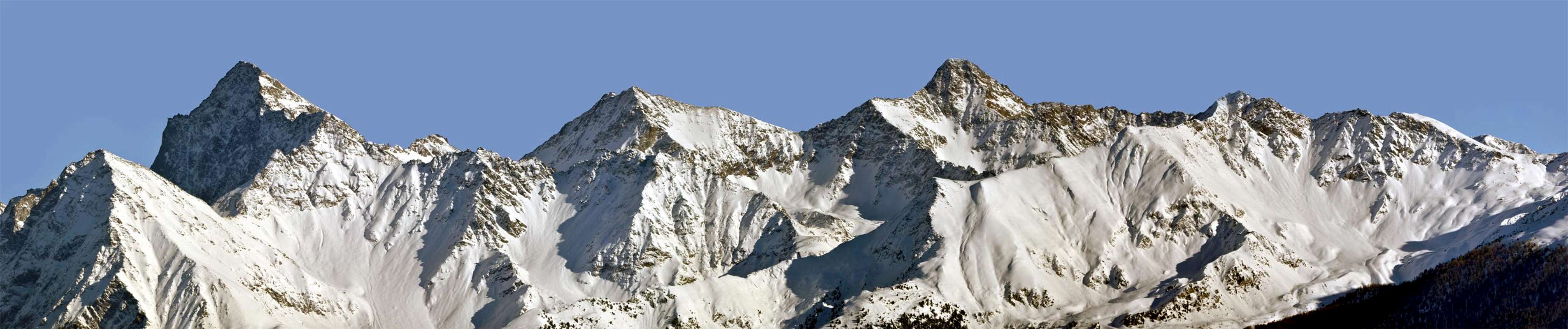
B) - South-southwest Buttress of Mount Emilius: from PilaThe two reddish and squared Red Towers on West Ridge (about 3.470/80m).
*******
In choosing this compilation is made the decision to offer something for everyone: for experienced climbers, mountaineers, "alpinucci" (= small & bad alpine mountaineers!),as my friend says when he meets Gigi Reverchon written smear and slander the Books of Peak leaving them with an adequate response, hikers, and why not, also to tourists, For the thing which the first 8 crossings are addressed to the first, the ninth hikers (but they can also take advantage by doing the first parts in these Routes, which are much hiking), while 'last crossing is aimed at peaceful tourists with good will to make a pleasant "with a high and strong legs", even in the company of childrens, so they can make contact with the area, visiting also some "sacred relic." Which is not too bad!
In describing these 10 Crossings of Emilius, we will give you even at the bottom of each mini a historical note, that make us participate, at least virtually, to the facts and events of the TIME ...*******
 |
In questa sezione proponiamo 10 traversate nell'intero Gruppo dell'Emilius, inteso fino al Colle di Saint Marcel o di Corona(s); da questo prende origine l'altro viciniore Gruppo della Tersiva (3.515 m), entrambi facenti parte delle cosiddette Alpi Graie di Sudest.
Nello scegliere questa compilazione s'é effettuata la decisione d'offrire a tutti qualcosa: ad alpinisti esperti, alpinisti, "alpinucci", come dice il mio amico Gigi Reverchon quand'incontra scritte che imbrattano ed offendono i Libri di Vetta, lasciando loro un'adeguata risposta, escursionisti e, perché no, anche ai turisti, Per la quale cosa le prime 8 traversate sono rivolte ai primi, la nona agli escursionisti (ma questi posson anche approfittar effettuando le prime parti in queste Routes, che sono decisamente escursionistiche), mentre l'ultima traversata é rivolta a tranquilli turisti con buona volontà d'effettuar una piacevole irrobustente sgambata, anche in compagnia di bambini, che posson così prendere contatto con la zona, visitando anche qualche "sacra reliquia". Il che non é poi così male!
Nel descrivere queste 10 Traversate dell'Emilius, vi daremo anche in calce ad ognuna una mini nota storica, tale da farci partecipare, almeno virtualmente, ai fatti ed agli eventi dell'EPOCA ...
From West to East Topographical Areas
A) - Wide Tour of the Pila Basin (Points de la Pierre, Drinc, Couiss, Grevon, Monpers, Tsa Setze, Valletta/Mount Belleface/Testa Nera/Dard).
B) - Jagged South-southwest Buttress of Mount Emilius (Comboé Trident,Frozen Loch Points, Pass & Mount Ròss of Comboé).
C) - Classic Traverse Becca of Nona/ Mount Ròss of Comboé/Little Emilius/Mount Emilius (Actually "Via Ferrata", since 2004).
D) - Wild Crossing Mount Père Laurent/ Points & Becca of Seneva/Peckoz Pass/Testa Blantsette & Carving/Black Triangle/Emilius.
E) - Oceanic Traverse Peak Garin/Mount Vallaisan & Pass/Emilius Three Red Points/Arbolle Hill/Point of Three Capuchins & Pass/Emilius.
F) - Indented South-southwest Buttress of Garin Peak (Points of Arpisson & Coupées of Arpisson/Arpisson's Tower/Point Fleurie/Lavà's Tops/Garin).
G) - Solitary crossing Laures Pass/Hill of Saint Marcel or Coronas through Lussert's-Leppe's Points & Vallonet's Pass & Mount.
H) - Fascinating Traverse Salé Becca & Pass/Little-Central (Junod Points)-Great Roises/Punta Ilario Antonio Garzotto/Leppe Hill.
I) - Exploratory Crossing Martsaouchy Alpages/Arpisson Walloon/Sources of Emilius/Carrel Hill (Federigo Zullo Bivouac)/Plan Valé/Comboé Walloon/Pila Res.
L) - Mystical Walking Reverier Dessous/Saint Joseph Chapel/Ponteilles Waterfall/Comboé Canons Shelter/Plan Fenetre Hill with Cross/St. Grat Hermitage/Pila Old & New Churc. Various Variants in descent to Aosta City or Pollein Municipality at the State Road n°26 or Motorway A5.
LEGENDA
T = for Tourists;
E = for Hikers;
EE = for Expert Hikers;
EE/A = for Expert Hikers & Mountaineers;
A = for Mountaineers;
AExp. = for Expert Mountaineers.
I° = Easy; altogether = F+;
II° = Not much Difficult; in all = from PD- to PD+;
III° = Enough Difficult; all in all = from AD- to AD+;
IV° = Difficult; totally from D- to D+.
h = Hours;
' = minutes
Examples. : 1h'30 = one hour and thirty minutes;
1h'30/4h'00 = 1h'30 partial time; 4h'00 = completely.
IMPORTANT REMARK
The first time reported is a partial, the second a partial sequence that adds to the previous, or a total time final excursion.
 |
Pila Resort/Grimondet Alp/Points de la Pierre Hill and Point/Drinc(k) Point and Pass/Couiss Point, with Arno Shelter (3h'00/3h'30)/Grevon Plate/ Monpers Point/Tsa Setze Point & Hill, Point of the Valletta/Mount Belleface/Testa Nera/Chamolé's Hill & Coastline/Replan Southern Hill, Point & Northern/Signal Sismonda/Plan of Fenetre Hill/Point of Ponteilles/Valletta Point W-SW Crest (EEA; 5h'00/5h'30). Point of Dard with descent to Saint Grat Hermitage or to Pila Resort (EE; F; 5h'00/6h'00).
 |
The history of this ridge dividing the Central Valley of the Dora
The other six sections, so we called and divided, are formed from these sections of the ridge:
1) - From Punta de la Pierre (2.653m) to Hill of Tsa Setze (2.815m), where since 2000 has been equipped a "Way Overview", that runs in full, on the watershed, near the Point of Couis or Couiss also Peak of the Tomb (2.660/1m), or the storm, stellar reached by Chairlift Couis II. On top of the same was built by the Company Alpila the small Hut Arno, on the remains of a small shelter erect by skiers of Aosta in the Fifties. Remember Faccarello Simone said, "Arno", Alpine Carrier of Aosta lover of this mountain, which led to the Queen of Italy Maria José all'Emilius in the Forties, but already in August of 1941 had been accompanied to the Drinc's Pass the Princess of Piedmont along with Principles. An 'other chairlift or Couis, seconded by a dirt road service, comes near the Platform of Grevon (2.752/1m).2) - This second section of the watershed ridge still divides the Pila Basin and the Valley of Cogne. It originates from the Col Tsa Setze, where the ridge widens temporarily up to a large grassy Shoulder (3.002m), and then shrink and become increasingly rocky, South-west of this Ridge has been equipped since 2003 a "Way Ferrata", which facilitates the most challenging passages or gory, due to the presence of grass and earth, and the fragility of the rock. Already covered in full in August 1969 and repeated, always on the edge of the ridge, by Osvaldo Cardellina and Nicola Colajanni August 20th, 2002, with the "works" carried out since then it becomes more feasible in these natural conditions, such as the West-northwest Ridge of th'Emilius. Both once rarely frequented, now passes by the masses.
3) - The third, the most classic, originates from the High Peak and descends to the North to act as a divider between the Vallon of Arbolle to the East and the Basin Plan de l'Eyve the opposite side; formed the Mont Belleface, or Bella Facà for the Abbot Henry in "RM", 1903, pages 73/8, (2.969/70m) arrives at Testa Nera, from an ancient Map Aoùille Neira, (Black Head) (2.819/20m), on which is placed a large metal cross (once was even higher and rustically wooden ), dedicated to hurdle racer of the Aosta Valley and Italian national team or "Azure" Marco Acerbi. Also in this section have been laid ropes, however, completely useless. In fact, the path is easy, safe and scenic.
The first historical find in the Monthly Magazine French "E'cho des Alpes", 1877, pp. 71/2 with the title "Correspondance" which concerned the ascension to the Point of the Valletta and the nearby hill of the same name, perhaps the world première of this peak by P.-L. Guignard: "... Wanting to go to Cogne, I crossed the mountain by climbing directly Charvensod, I spent a pass more than 9,000 feet, I could not find out the name and climbed the nearest summit which, after the barometer accused about 9,900 p,. collar and Mount remained nameless for me, I was without a guide, not having succeeded to get one (this pass should be Col Vallette (Note of Sub-editor) ... ". Even Agostino Ferrari in "Statistics of first ascents in the Great Paradise", 1908, recognizes it as a first ascent. Known at least since inhabitants and hunters had almost certainly already busy. The oddity is that the Guignard, under these conditions, have not used the neighboring Hills of Garin or Tsa Setze, easier, safer and faster. But, as he says, not knowing the area and rather observing the cardinal points, where it is supposed to be Arbolle, Cogne remains at Midday, while the Garin Hill you do not know where to go, the choice seems plausible and even logical. The first winter crossing, uphill and downhill from Pila and the Chamolé, these three peaks has been accomplished by six mountaineers of Aosta, including the then Colonel, then General, Alpine Troops Edy Covi, 30 December 1977.
The first historical find in the Monthly Magazine French "E'cho des Alpes", 1877, pp. 71/2 with the title "Correspondance" which concerned the ascension to the Point of the Valletta and the nearby hill of the same name, perhaps the world première of this peak by P.-L. Guignard: "... Wanting to go to Cogne, I crossed the mountain by climbing directly Charvensod, I spent a pass more than 9,000 feet, I could not find out the name and climbed the nearest summit which, after the barometer accused about 9,900 p,. collar and Mount remained nameless for me, I was without a guide, not having succeeded to get one (this pass should be Col Vallette (Note of Sub-editor) ... ". Even Agostino Ferrari in "Statistics of first ascents in the Great Paradise", 1908, recognizes it as a first ascent. Known at least since inhabitants and hunters had almost certainly already busy. The oddity is that the Guignard, under these conditions, have not used the neighboring Hills of Garin or Tsa Setze, easier, safer and faster. But, as he says, not knowing the area and rather observing the cardinal points, where it is supposed to be Arbolle, Cogne remains at Midday, while the Garin Hill you do not know where to go, the choice seems plausible and even logical. The first winter crossing, uphill and downhill from Pila and the Chamolé, these three peaks has been accomplished by six mountaineers of Aosta, including the then Colonel, then General, Alpine Troops Edy Covi, 30 December 1977.
4) - This stretch is short but twofold, in that it offers two possibilities:
a) - Continue on the watershed until Chamolé Hill for not difficult, but steeper Northeast Ridge (Old Via, the busiest times in the past, with the first track on the Northern Side and then immediately below the crest; route sign in yellow near the hill) is used to go to the Refuge Arbolle.
b) - Descend along the North-western Side by a smaller and easier, as well as less steep trail, poorly marked, that track a few years ago, is the initial or final, whether downhill, the "Via degli Alpini". Not because it is frequented by Alpine Troops (we have never seen one, if not the Colonel Covi and my Friend General Roberto Stella, just what the winner of the" Mezzalama Trophy" 1971), but because it was dedicated to all soldiers of Gressan Municipality, that there are no more, with a high iron Cross and a plaque with all their names on the Top of the Valletta. This brings the arrival of your Chairlift to the Chamolé Lake (2.309m).
5) - Taking up the watershed ridge you can take the rocky grassy Costa Chamolé's Coastline (2.580m, 2.509m), is a dangerous route to the presence of large sections of grass on the rocks and ends with a short, but steep, rock step before the two Hills and the Point Replan. Preferably to be avoided, it can serve only in winter climbing from the East shore of Lake Chamolé (2.325m) to avoid, in the presence of dangerous snow, the slope below the eponymous hill. Cross it only if you really want to make the Lap of Pila Basin.
6) - Contrary to the previous section of the ridge is a very useful and very popular for the passage in the beautiful Walloon of Comboé at the foot of Becca and Emilius. After an initial Replan Hill, less used and steepest descent in the East, the same name and the subsequent small Point (scenic wooden bench between the two) opens the Hill of Northern Replan (2.366m), a real door in the crossing from the lake in this small walloon. Over the ridge continues with a beautiful path, bypassing some roughness immediately to the West, reaches an altitude secondary and then the Signal Sismonda, dedicated to a great Naturalist and Scientist, on which the ruins still Rimage perimeter of the Astronomical Observatory erected for him and dedicated to him by his friend Georges Canon Carrel (2.343m). Just below you open the Col Plan Fenetre with the beautiful mule track from Pila, or from the Hermitage of Saint Grat, falls Comboé. From this important window, the ridge proceeds with the section treated in the opening to the Top of Dard, or
7) - This last part, if you really want to go, requires the ascent of the hill, because the other descents on the slopes are very little advisable and safe, especially when children are present (possibility to meet the viper).
 |
 |
 |
La storia di questa cresta spartiacque tra la Valle della Dora e quella di Cogne
prima. nonché tra i Valloni del Plan de l'Eyve/Comboé nel tratto successivo discendente dalla Punta della Valletta (3.090 m), massima elevazione di questo tanto piccolo quanto estesamente vasto sottogruppo montuoso, si perde, anche alpinisticamente parlando, nella Notte dei Tempi. Un terzo settore, più basso e rivolto a Settentrione, divide la Conca di Pila da quella del Dard; paradossalmente risulta il più ed anche il meno frequentato. Infatti inizia dal Colle Plan de Fenetre (2.229 m), punto di maggiore transito dell'intero Gruppo dell'Emilius, almeno fino all'apertura del Rifugio di Arbolle, ma procede verso Nord con una cresta che digrada formando le Punte di Ponteilles, Valletta e del Dard (2.033 m), detta anche "Pointe du Rem", ovvero del rame, precipitante boschivo-rocciosa sull'Alpe di Pousses o Pouces in Charvensod. Quest'ultima sezione risulta quasi del tutto infrequentata e sul crinale scende un sentierucolo, a tratti coperto dalla vegetazione, tracciato più dal Corpo Forestale, per segnare le particelle del bosco, che non dal passaggio d'escursionisti. Ciononostante era già frequentata nel passato, tant'é ch'era stata utilizzata dalla locale e famosa Guida "a mulo" Grégoire Comé per accompagnare fino al Comboé, transitando per un valloncello boschivo a Settentrione della Punta Valletta (2.164 m), il 19 Dicembre 1889 la comitiva Alessandro Emilio Martelli, Silvio Miglietti con la Guida di Valtournanche Jean Baptiste Aymonod; gli stessi il giorno appresso compirono la prima salita invernale della Becca di Nona, mentre Grégoire se ne tornò, stessa via, a Charvensod.
prima. nonché tra i Valloni del Plan de l'Eyve/Comboé nel tratto successivo discendente dalla Punta della Valletta (3.090 m), massima elevazione di questo tanto piccolo quanto estesamente vasto sottogruppo montuoso, si perde, anche alpinisticamente parlando, nella Notte dei Tempi. Un terzo settore, più basso e rivolto a Settentrione, divide la Conca di Pila da quella del Dard; paradossalmente risulta il più ed anche il meno frequentato. Infatti inizia dal Colle Plan de Fenetre (2.229 m), punto di maggiore transito dell'intero Gruppo dell'Emilius, almeno fino all'apertura del Rifugio di Arbolle, ma procede verso Nord con una cresta che digrada formando le Punte di Ponteilles, Valletta e del Dard (2.033 m), detta anche "Pointe du Rem", ovvero del rame, precipitante boschivo-rocciosa sull'Alpe di Pousses o Pouces in Charvensod. Quest'ultima sezione risulta quasi del tutto infrequentata e sul crinale scende un sentierucolo, a tratti coperto dalla vegetazione, tracciato più dal Corpo Forestale, per segnare le particelle del bosco, che non dal passaggio d'escursionisti. Ciononostante era già frequentata nel passato, tant'é ch'era stata utilizzata dalla locale e famosa Guida "a mulo" Grégoire Comé per accompagnare fino al Comboé, transitando per un valloncello boschivo a Settentrione della Punta Valletta (2.164 m), il 19 Dicembre 1889 la comitiva Alessandro Emilio Martelli, Silvio Miglietti con la Guida di Valtournanche Jean Baptiste Aymonod; gli stessi il giorno appresso compirono la prima salita invernale della Becca di Nona, mentre Grégoire se ne tornò, stessa via, a Charvensod.
Le altre sei sezioni, così da noi chiamate e suddivise, sono formate da questi tratti della cresta:1) - dalla Punta de la Pierre (2.653 m) al Colle di Tsa Setze (2.815 m), ove dagli anni 2000 é stata attrezzata una "Via Panoramica", che la percorre integralmente; sullo spartiacque, nei pressi della Punta del Couis o Couiss (2.660/1 m), ovvero della tormenta, viena raggiunta dalla Seggiovia Couis II. In cima alla medesima é stato costruito da parte della Società Alpila il Ricovero Arno, sui resti d'un piccolo rifugio eretto dagli sciatori di Aosta negli Anni Cinquanta. Ricorda Simone Faccarello detto "Arno", Portatore Alpino di Aosta amante di quest monti, che portò la Regina d'Italia Maria Josè all'Emilius negli Anni Quaranta; ma già nell'Agosto del 1941 era stata accompagnata al Colle del Drinc la Principessa del Piemonte insieme ai Principini. Un' altra seggiovia o del Couis I, assecondata da una strada sterrata di servizio, perviene nei pressi della Piatta di Grevon (2.752/1 m).
2) - Questa seconda sezione della cresta spartiacque divide ancora la Conca di Pila e la Valle di Cogne. S'origina dal Col Tsa Setze, ove la cresta si allarga momentaneamente fino ad uno Spallone erboso (3.002 m), per poi restringersi e diventare progressivamente rocciosa; su questa Cresta Sudovest é stata attrezzata dal 2003 una "Via Ferrata", che facilita i passaggi più impegnativi o scabrosi, causa la presenza d'erba e terriccio e la fragilità della roccia. Già percorsa integralmente in Agosto 1969 e ripetuta, sempre sul filo di cresta, da Osvaldo Cardellina e Nicola Colajanni il 20 Agosto 2002, con le "opere" eseguite da allora non diventa più fattibile in queste condizioni naturali; come la Cresta Ovest-nordovest dell'Emilius. Entrambe una volta raramente frequentate, ora vedono transitare le masse.
3) - La terza, la più classica, s'origina dalla Vetta Massima e scende verso Settentrione a far da divisorio tra il Vallone dell' Arbolle ad Oriente ed il Bacino del Plan de l'Eyve nel lato opposto; formato il Mont Bellefaçe, oppure Bella Faça per l'Abate Henry in "RM" 1903, pagine 73/8, (2.969/70 m) giunge alla Testa Nera, in un'antica Mappa Aoùille Neira, (2.819/20 m), sulla qual é posta una grande croce metallica (una volta era ancora più alta e rusticamente in legno), dedicata all'ostacolista Valdostano ed Azzurro Marco Acerbi. Anche in questo tratto sono state posate delle funi, peraltro del tutto inutili. Infatti il percorso é facile, sicuro e panoramico.
Le prime notizie storiche le troviamo nella Rivista Mensile francese "E'cho des Alpes" 1877, pagine 71/2 in con il titolo "Correspondance" riguardante l'ascensione alla Punta della Valletta e del vicino omonimo colle, forse la prima assoluta di questa cima da parte di P.-L. Guignard: " ... Voulant me rendre à Cogne, je traversai la montagne directement en montant par Charvensod, je passai un col de plus de 9,000 pieds, dont je ne pus savoir le nom et gravis la cime la plus rapprochée qui, d'aprés le barométre accusait 9,900 p. environ; col et mont sont restés sans nom pour moi, j'étais sans guide, n'ayant pas reussi à m'en procurer un (ce col doit etre le Col Vallette N.d.R.) ... ". Anche Agostino Ferrari in "Statistica delle prime ascensioni nel gruppo del Gran Paradiso", 1908, la riconosce come prima ascensione. Almeno conosciuta, poiché valligiani e cacciatori l'avevan quasi sicuramente già frequentata. La stranezza é che il Guignard, in siffatte condizioni, non abbia utilizzato i vicini Colli di Garin o di Tsa Setze, più facili, sicuri e rapidi. Ma, come lui dice, non conoscendo la zona e piuttosto osservandola a mezzo dei punti cardinali dove, si suppone da Arbolle, Cogne resta a Mezzogiorno, mentre il Col Garin non si sà dove porti, la scelta appare plausibile e persin logica. La prima traversata invernale, in salita e discesa da Pila e per il Colle di Chamolé, di queste tre cime é stata compiuta da sei alpinisti di Aosta, tra i quali l'allora Colonnello, poi Generale, delle Truppe Alpine Edy Covi, il 30 Dicembre 1977.
4) - Questo tratto é breve ma duplice, nel senso che offre due possibilità:
a) - Continuare sullo spartiacque fino al Colle di Chamolé per la non difficile ma più ripida Cresta Nordest (vecchia via, la più frequentata nei tempi trascorsi, con tracce prima sul Versante Settentrionale e poi subito al di sotto della cresta; cartello segnaletico in giallo al colle); é utilizzata per recarsi al Rifugio di Arbolle.
b) - Scendere lungo il Versante Nordovest tramite un piccolo e più facile, oltre che meno ripido, sentiero, mal segnalato, che, tracciato da pochi anni, costituisce la parte iniziale o finale, se in discesa, della "Via degli Alpini". Non perché sia frequentato dagli "Alpini (non ne abbiamo mai visto uno solo, se non il Colonnello Covi ed il mio Amico Generale Roberto Stella, si proprio quello vincitore del "Trofeo Mezzalama" 1971), ma perché é stata dedicata a tutti i soldati di Gressan, che non ci son più, con un'alta Croce in ferro ed una targa con tutti i loro nomi in punta alla Valletta. Questa via porta proprio all'arrivo della Seggiovia per il Lago di Chamolé (2.309 m).
5) - Riprendendo la cresta spartiaqcue si può percorrere la roccioso-erbosa Costa di Chamolé (2.580 m, 2.509 m); é un itinerario percicoloso per la presenza di vasti strati erbosi insiti nelle rocce e si conclude con un breve, ma ripido, salto roccioso prima dei due Colli e la Punta di Replan. Preferibilmente da evitare, può servire solamente in inverno salendolo dalla sponda Est del Lago di Chamolé (2.325 m) onde evitare, in presenza di neve pericolosa, il pendio sottostante all'omonimo colle. Lo si percorre soltanto nel caso vogliasi proprio effettuare il Giro completo della Conca di Pila.
6) - Contrariamente al precedente é un tratto di cresta di grande utilità e molto frequentato per il passaggio nello splendido Vallone del Comboé, ai piedi della Becca e dell'Emilius. Dopo un primo Colle di Replan, meno utilizzato e più ripido nella discesa ad Est, la successiva omonima e piccola punta (panca panoramica in legno tra i due) si apre il Colle Settentrionale di Replan (2.366 m), vera porta di ingresso nella traversata dal lago a questo valloncello. Oltre la cresta prosegue con un bel sentiero che, aggirando qualche asperità subito ad Ovest, raggiunge una quota secondaria e successivamente il Segnale Sismonda, dedicato ad un grande Naturalista e Scienziato, sul quale rimagono ancora le rovine perimetrali dell'Osservatorio Astronomico per lui eretto ed a lui dedicato dall'amico Canonico Georges Carrel (2343 m). Poco sotto si apre il Colle Plan Fenetre con la splendida mulattiera che da Pila, oppure dall'Eremitaggio di San Grato, scende al Comboé. Da quest'importante finestra la cresta procede con la sezione trattata in apertura insino alla Punta del Dard ovvero
7) - Quest'ultimo tratto, se proprio lo si vuole percorrere, richiede la risalita al colle, poiché le altre discese sui versanti sono davvero poco consigliabili e sicure, soprattutto in presenza di bambini (possibilità d'incontrar la vipera).
B) - South-southwest Buttress of Mount Emilius: from PilaThe two reddish and squared Red Towers on West Ridge (about 3.470/80m).
 |
Pila Resort/Chamolé Alp Lake & Hill/Arbolle Vallon, Lochs and Refuge (E; F; 1h'30h/1h'45). Through S-SW Crest to Comboé Trident SW, Central and NE Summits/Frozen Loch Points/Pass & Mount Ròss of Comboé (2h'30/3h'00) and West Ridge of Mount Emilius (2h'00/2h'30). Descent, through E-SE Crest (Standard Route) to Three Capuchins Pass/Frozen Loch/Arbolle Wallon-Lake & Refuge and with the same itinerary, or alternative through Comboé Vallon/Comboé Alp and of Saint Ours Canons House/Plan Fenetre Hill/Chamolé Alp to Pila (A; from PD- to AD+; passages of II°/III° and III°+; 11h'00/12h'00).
******* Historical FEATURES
The history of this long and unknown buttress
(paradoxically because in full view from Pila, from Chamolé, a stone's throw from Lake Arbolle and just above the Hut, Frozen Lake , climbing to and on Emilius, from Garin Pass, as well as Comboé, from the Carrel Hill and "Becca" and frontally from all over the ridge of Point of the Valletta) binds directly to that of the W-NW Ridge of Emilius, joining to this at the Top of Mount Ròss of Comboé (3.301m) or large Shoulder at the end of West Ridge Emilius-Little Emilius, from this point it splits into Northwest and Southwest triangular form in a perfect way the West Face of Mount Ròss, squeezed between the Col Carrel and Col Ròss. This last is split into two little collars separated by a small elevation in the form of a closed fist with the knuckles out: the first is to the North, although higher (3.091 m), the real point of transition between the Walloons of Comboé and to Arbolle-Frozen Lake and the second consisting of a mini saddle rounded it is not convenient, although slightly lower (about 3.075m). Despite being in the spotlight has remained hidden in oblivion for millennia, centuries and decades, at least until August 4th, 1974 when was it rose up with a full crossing on the "thread", to Emilius, which can be defined mammoth, if not for its difficulty, definitely for the path length. This is the ridge that leads all'Emilius longer, even longer than that, starting from Mount Père Laurent and overcoming the same name three small tops, The Cordagnì or The Ante Top Northern of Becca of Seneva, the two homonym small Towers and the same, Col Peckoz, the Head and Blantsette's Carving, the Black Triangle, arrives at the Peak. Dividing the Walloons of Arpisson and Laures has never been, however, entirely uphill reducing paths in disjoint sections of the same (see Section L -). While the Buttress Southwest constitutes the stem of the left (the other is directed to Becca di Nona) of a large Y directed to the West the base of which consists in the Peak, from this, always in topographical sense, descends with continuous line the Buttress Northeast above, this draws a large arch, convex towards the East, which ends with the huge ramparts of Mount Père Laurent, with high cliffs, "threatening" over populated areas of Grand Pollein and Brissogne.But returning in a more targeted way to our own, to be observed as it wanders from the Mount Ròss to Southwest forming in succession the two collars of Col Ròss, the 7/8 elevations on Point of Frozen Lake (3.113/5m, the highest in like a small square forked tower), the Comboé's Pass and the namesake Trident, as the name implies, consists of three separate summits on the shaft NE/SW, the highest of which is the NE Summit (3.083m), followed from Central Top (about 3.070m) and SW Point (3.051m). If seen by Northwest (for ex. Ancient Alp Bren Dessus (1.672 m), a magnificent place with views from the old decadent "rascard" between Turlin Dessus and Pila) in succession offer this: a tower with serrated at least six turrets, a rounded top in its lines and finally a perfect little triangular pyramid, from which descends towards the West-northwest a "Crestone". Among the latter two down a gully, where the snow remains even in the hottest summers.
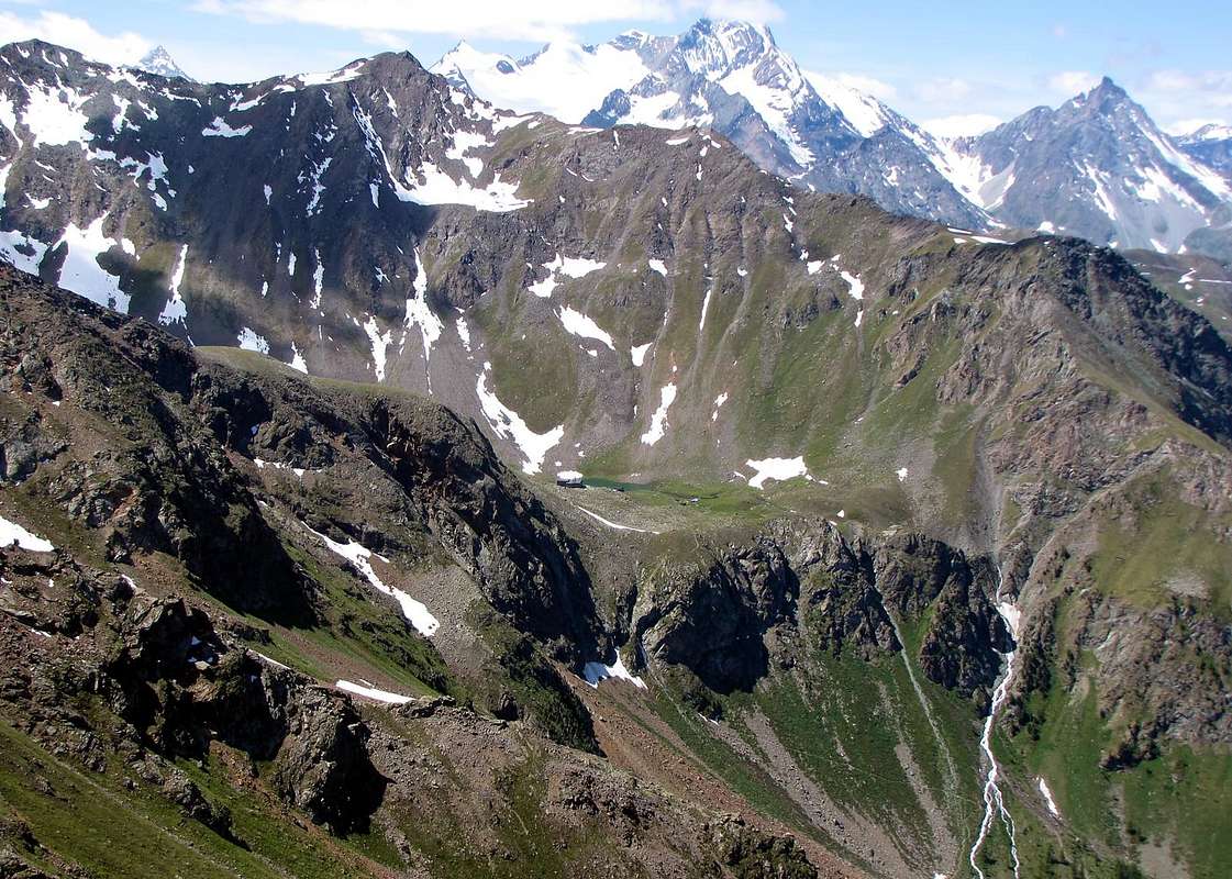
From this last point the ridge slopes linear, again towards the South-west, through fifteen small elevation, falling over the Walloon of Arbolle with its two lakes, connected through the effluent and the Shelter, just above the same (2516m; open since July 1998; 66 beds, open in the summer season and adjacent locales for the winter), in this last section the ridge goes down with easy broken rocks and mixed with grass. Spreading, forms a vast grassy plain with scattered blocks, chats which was built with the Refuge nearby fountain.
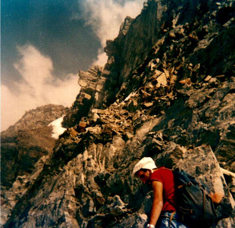
Surely the Southwest Top and the Central had already been reached by herdings or huntings, as reflected by the first climbers who, on the middle one, they found, as well as small traces of passage, a pole of the hunting ban. But from then on the ridge becomes more tricky and from Northeast Summit rushes with a jump of about seventy metres below the Col de Comboé (3.014 m), descent, not easy, takes place through a rift-chimney about 25 feet "clogged" blocks stuck. It is possible to avoid this step across to the West of a steep ledge debris. The jump itself is divided into two parts, the first of which about forty meters, inclusive of the above passage, and a second a hundred feet less steep that reaches the Col de Comboé (3.014m) reaching the pass. But the first climbers, Osvaldo Cardellina and Camillo Roberto Frerronato, walked the ridge by real "purists", climbing every little relief on the edge. With joy of the poor according to who arrived at the Col Ròss, wanted to stop the marathon and to hell with the company, because, he said he had had enough and despite the steep slope of the hill looked like a wedding invitation. Instead continued "faithfully" to Mount Ròss of Comboé and from there, turning at a right angle and inserting the ridge coming from the Hill Carrel, went to the Little Emilius, scaled the reddish red towers, always avoided by, for truth few, previous climbs, stopping at "Grey Jump". At this point a sock idea occurred to him: conclude, as did the climbers of August 30th, 1897, on the North Wall through a crossing of steep rocks, trite and marches (see photo). Just a nice idea! After a day of up and down. Stuff maybe the hammer on the balls ... However, they reached the top anyway.
Since then, there are more other climbs on this long buttress, and frankly, we can not understand that, when viewed from below. You are fully justified! Other ascents were made but only on limited sections, such as the two spurs of the Western Trident and Frozen Loch Points or on the West Face of Mount Ròss. But always with arrival on top of the same summits or short extensions of the via. Never completely...
But if some of you were just as The Camillo says, the "healthy ill" IDEA remember to take plenty of water with You, and why are there we do not view. Also keep in mind that the magnetic rocks dark red of th'Emilius reflected in an exceptional way the sun. And the travel time? The first climbers took them over 8h'00 starting from Pila to share approximately 1.750 meters and other 3h'00 for the return. Calculate 1 good full day of "up and down".
Ah! I forgot. In case of storms, give up ...
*******
 |
 |
 |
The history of this long and unknown buttress
(paradoxically because in full view from Pila, from Chamolé, a stone's throw from Lake Arbolle and just above the Hut, Frozen Lake , climbing to and on Emilius, from Garin Pass, as well as Comboé, from the Carrel Hill and "Becca" and frontally from all over the ridge of Point of the Valletta) binds directly to that of the W-NW Ridge of Emilius, joining to this at the Top of Mount Ròss of Comboé (3.301m) or large Shoulder at the end of West Ridge Emilius-Little Emilius, from this point it splits into Northwest and Southwest triangular form in a perfect way the West Face of Mount Ròss, squeezed between the Col Carrel and Col Ròss. This last is split into two little collars separated by a small elevation in the form of a closed fist with the knuckles out: the first is to the North, although higher (3.091 m), the real point of transition between the Walloons of Comboé and to Arbolle-Frozen Lake and the second consisting of a mini saddle rounded it is not convenient, although slightly lower (about 3.075m). Despite being in the spotlight has remained hidden in oblivion for millennia, centuries and decades, at least until August 4th, 1974 when was it rose up with a full crossing on the "thread", to Emilius, which can be defined mammoth, if not for its difficulty, definitely for the path length. This is the ridge that leads all'Emilius longer, even longer than that, starting from Mount Père Laurent and overcoming the same name three small tops, The Cordagnì or The Ante Top Northern of Becca of Seneva, the two homonym small Towers and the same, Col Peckoz, the Head and Blantsette's Carving, the Black Triangle, arrives at the Peak. Dividing the Walloons of Arpisson and Laures has never been, however, entirely uphill reducing paths in disjoint sections of the same (see Section L -). While the Buttress Southwest constitutes the stem of the left (the other is directed to Becca di Nona) of a large Y directed to the West the base of which consists in the Peak, from this, always in topographical sense, descends with continuous line the Buttress Northeast above, this draws a large arch, convex towards the East, which ends with the huge ramparts of Mount Père Laurent, with high cliffs, "threatening" over populated areas of Grand Pollein and Brissogne.But returning in a more targeted way to our own, to be observed as it wanders from the Mount Ròss to Southwest forming in succession the two collars of Col Ròss, the 7/8 elevations on Point of Frozen Lake (3.113/5m, the highest in like a small square forked tower), the Comboé's Pass and the namesake Trident, as the name implies, consists of three separate summits on the shaft NE/SW, the highest of which is the NE Summit (3.083m), followed from Central Top (about 3.070m) and SW Point (3.051m). If seen by Northwest (for ex. Ancient Alp Bren Dessus (1.672 m), a magnificent place with views from the old decadent "rascard" between Turlin Dessus and Pila) in succession offer this: a tower with serrated at least six turrets, a rounded top in its lines and finally a perfect little triangular pyramid, from which descends towards the West-northwest a "Crestone". Among the latter two down a gully, where the snow remains even in the hottest summers.
From this last point the ridge slopes linear, again towards the South-west, through fifteen small elevation, falling over the Walloon of Arbolle with its two lakes, connected through the effluent and the Shelter, just above the same (2516m; open since July 1998; 66 beds, open in the summer season and adjacent locales for the winter), in this last section the ridge goes down with easy broken rocks and mixed with grass. Spreading, forms a vast grassy plain with scattered blocks, chats which was built with the Refuge nearby fountain.
Surely the Southwest Top and the Central had already been reached by herdings or huntings, as reflected by the first climbers who, on the middle one, they found, as well as small traces of passage, a pole of the hunting ban. But from then on the ridge becomes more tricky and from Northeast Summit rushes with a jump of about seventy metres below the Col de Comboé (3.014 m), descent, not easy, takes place through a rift-chimney about 25 feet "clogged" blocks stuck. It is possible to avoid this step across to the West of a steep ledge debris. The jump itself is divided into two parts, the first of which about forty meters, inclusive of the above passage, and a second a hundred feet less steep that reaches the Col de Comboé (3.014m) reaching the pass. But the first climbers, Osvaldo Cardellina and Camillo Roberto Frerronato, walked the ridge by real "purists", climbing every little relief on the edge. With joy of the poor according to who arrived at the Col Ròss, wanted to stop the marathon and to hell with the company, because, he said he had had enough and despite the steep slope of the hill looked like a wedding invitation. Instead continued "faithfully" to Mount Ròss of Comboé and from there, turning at a right angle and inserting the ridge coming from the Hill Carrel, went to the Little Emilius, scaled the reddish red towers, always avoided by, for truth few, previous climbs, stopping at "Grey Jump". At this point a sock idea occurred to him: conclude, as did the climbers of August 30th, 1897, on the North Wall through a crossing of steep rocks, trite and marches (see photo). Just a nice idea! After a day of up and down. Stuff maybe the hammer on the balls ... However, they reached the top anyway.
Since then, there are more other climbs on this long buttress, and frankly, we can not understand that, when viewed from below. You are fully justified! Other ascents were made but only on limited sections, such as the two spurs of the Western Trident and Frozen Loch Points or on the West Face of Mount Ròss. But always with arrival on top of the same summits or short extensions of the via. Never completely...
But if some of you were just as The Camillo says, the "healthy ill" IDEA remember to take plenty of water with You, and why are there we do not view. Also keep in mind that the magnetic rocks dark red of th'Emilius reflected in an exceptional way the sun. And the travel time? The first climbers took them over 8h'00 starting from Pila to share approximately 1.750 meters and other 3h'00 for the return. Calculate 1 good full day of "up and down".
Ah! I forgot. In case of storms, give up ...
 |
 |
 |
La storia di questo lungo e sconosciuto contrafforte
(paradossalmente perché in piena vista da Pila, dal Colle di Chamolé, a due passi dal Lago d'Arbolle ed appena sovrastante il Rifugio, dal Lago Gelato, salendo all'Emilius, dal Col Garin, nonché dal Comboé, dal Colle Carrel e dalla Becca e, frontalmente, da tutta la cresta della Punta della Valletta) si lega direttamente a quella della Cresta W-NW dell'Emilius, congiungendosi a questa in cima al Mont Ròss de Comboé (3.301 m) o Spallone al termine della Cresta Ovest Emilius-Piccolo Emilius; da questo punto essa si sdoppia in Nordovest e Sudovest formando in modo perfetto la triangolare Parete Ovest del Mont Ròss, stretta tra i Colli Carrel e Ròss. Quest'ultimo si soppia in due colletti inframmezzati da una piccola elevazione a forma di pugno chiuso con le nocche in evidenza: il primo a Nord costituisce, anche se più elevato, (3.091 m), il punto vero di transito tra il Valloni del Comboé e di Arbolle-Lago Gelato; il secondo formato da una sella arrotondata non é conveniente, anche se di poco più basso (3.075 metri circa). Nonostante sia in grand'evidenza é rimasto nascosto nell'oblio per millenni, secoli e decenni; almeno fino al 4 Agosto 1974 quando é stato salito con una traversata integrale, sul filo di cresta fino all'Emilius, da definirsi ciclopica, se non per le sue difficoltà, sicuramente per la lunghezza del percorso. Risulta questa la cresta più lunga adducente all'Emilius, persin più lunga di quella che, partendo dal Mont Père Laurent e superando le omonime tre piccole punte, Lo Cordagnì od Ante Cima Settentrionale della Becca di Seneva, i due omonimi e piccoli Torrioni e la medesima, il Col Peckoz, la Testa ed il Col Blantsette, il Triangolo Nero, arriva alla Vetta. Divisoria i Valloni dell' Arpisson e delle Laures non é mai stata, peraltro, integralmente salita riducendosi i percorsi a sezioni disgiunte della stessa (vedi punto L - ). Mentre il Contrafforte Sudovest costituisce il gambo di sinistra (l'altro si indirizza alla Becca di Nona) di una grande Y rivolta ad Occidente la base della quale consiste nella Vetta, da questa, sempre in senso topografico, scende con linea continua il Contrafforte Nordest di cui sopra; questo disegna un grande arco, convesso verso Oriente, che termina con l'enorme bastionata del Mont Père Laurent, con alte pareti rocciose, "minacciose" sopra gli abitati di Grand Pollein e Brissogne.
Ma ritornando in modo più mirato al nostro, da osservare com'esso si snodi dal Mont Ròss verso Sudovest formando in successioni i due colletti del Col Ròss, le 7/8 elevazioni delle Punte del Lago Gelato (3.113/5 m, la più elevata a guisa di piccola torre squadrata e bifida), il Col de Comboé e l'omonimo Trident, come dice la parola, costituito da tre distinte sommità poste sull'asse NE/SO, la più alta delle quali é la Punta NE (3.083 m), seguita dalla Punta Centrale (3.070 m circa) e dalla SW (3.051 m). Se viste da Nordovest (ad esempio l'Alpe di Bren Dessus (1.672 m), magnifico posto d'oservazione con vecchio "rascard" decadente tra Turlin Dessus e Pila, in successione offron questa immagine: una torre dentellata con almeno sei torrette, una punta arrotondata nelle sue linee ed infine una perfetta piccola piramide triangolare, dalla quale scende verso Ovest-nordovest un Crestone. Tra queste ultime due discende un canalone, ove la neve resiste anche nelle estati più torride.
Da quest'ultima punta la cresta digrada lineare, sempre in direzione Sudovest tramite una quindicina di piccole elevazioni, discendendo sopra il Vallone dell' Arbolle con i suoi due laghi, collegati dall'emissario del primo od Orientale, ed il Rifugio, appena sopra i medesimi (2.516 m; aperto dal Luglio 1998; 66 posti letto; aperto nella stagione estiva ed adiacente locale per quella invernale); in quest'ultimo tratto la cresta scende con facili rocce rotte frammiste ad erba. Allargandosi, forma un vasto plateau erboso con blocchi sparsi o "clapeys", oltre il quale é stato costruito il Rifugio con vicina fontana.
Sicuramente la Punta Sudovest e quella Centrale eran di già state visitate da pastori o cacciatori, come da riscontro dei primi salitori che, su quella di mezzo, trovarono, oltre a piccole tracce di passaggio, una palina di divieto di caccia. Ma da lì in avanti la cresta diventa più ostica e dalla Punta Nordest precipita con un salto di una settantina di metri circa sul sottostante Col de Comboé (3.014 m); la discesa, non facile, avviene tramite una spaccatura-camino di circa 25 metri "intasato" da blocchi incastrati. Risulta possibile evitare questo passaggio attraversando ad Ovest su d'una ripida cengia detritica. Lo stesso salto é suddiviso in due parti, delle quali la prima d'una quarantina di metri, comprensiva del passaggio di cui sopra, ed una seconda d'una trentina di metri, meno ripida, che raggiunge il Col de Comboé (3.014 m). Ma i primi salitori, Osvaldo Cardellina e Camillo Roberto Ferronato, percorsero la cresta da veri "puristi", scalando ogni benché minimo rilievo sul filo. Con scarsa gioia del secondo che, giunti al Col Ròss, voleva interromper la maratona e mandar al diavolo l'impresa, perché, a suo dir ne aveva abbastanza ed il pur ripido pendio del colle sembrava proprio un invito a nozze. Invece proseguirono "fedelmente" insino al Mont Ròss de Comboé e da lì, svoltando ad angolo retto ed inserendosi sulla cresta proveniente dal Colle Carrel, passaron al Piccolo Emilius, scalarono le rossastre torri rosse, sempre evitate dalle, per verità poche, precedenti salite, fermandosi al "Salto Grigio". A questo punto venne in mente una, a dir poco, balzana idea: concludere come fece la cordata del 30 Agosto 1897, sulla Parete Nord tramite una traversata su rocce ripide, trite e marce (vedi foto). Proprio una bell'invenzione! Dopo una giornata di sù e giù. Roba da darsi le martellate sulle palle... Comunque giunsero in cima ugualmente.
D'allora non risultano più altre salite su questo lungo contrafforte e, sinceramente, non possiamo che pienamente capire, se lo s'osserva dal basso. Siete ampiamente giustificati! Altre salite sono state effettuate ma soltanto su tratti parziali, come sui due speroni Occidentali del Trident e delle Punte del Lago Gelato oppure sulla Parete Ovest del Mont Ròss. Ma sempre con arrivo in cima alle medesime punte o con corti prolungamenti di percorso. Mai completamente... Ma se a qualcun di Voi venisse proprio, come dice il Camillo, la "mal sana" IDEA ricordatevi di prendere con voi tanta acqua, perché su di là non se n'é vista. Inoltre tenete a mente che le magnetiche rocce rosso scuro dell'Emilius riflettono in modo eccezionale il sole. Ed il tempo di percorrenza? I primi salitori impiegarono oltre 8h'00 partendo da Pila a quota 1.750 metri circa ed altre 3h'00 per il rientro; calcolare 1 buona intera giornata di "sù e giù".Ah! dimenticavo. In caso di temporali, rinunciare...
*******
(paradossalmente perché in piena vista da Pila, dal Colle di Chamolé, a due passi dal Lago d'Arbolle ed appena sovrastante il Rifugio, dal Lago Gelato, salendo all'Emilius, dal Col Garin, nonché dal Comboé, dal Colle Carrel e dalla Becca e, frontalmente, da tutta la cresta della Punta della Valletta) si lega direttamente a quella della Cresta W-NW dell'Emilius, congiungendosi a questa in cima al Mont Ròss de Comboé (3.301 m) o Spallone al termine della Cresta Ovest Emilius-Piccolo Emilius; da questo punto essa si sdoppia in Nordovest e Sudovest formando in modo perfetto la triangolare Parete Ovest del Mont Ròss, stretta tra i Colli Carrel e Ròss. Quest'ultimo si soppia in due colletti inframmezzati da una piccola elevazione a forma di pugno chiuso con le nocche in evidenza: il primo a Nord costituisce, anche se più elevato, (3.091 m), il punto vero di transito tra il Valloni del Comboé e di Arbolle-Lago Gelato; il secondo formato da una sella arrotondata non é conveniente, anche se di poco più basso (3.075 metri circa). Nonostante sia in grand'evidenza é rimasto nascosto nell'oblio per millenni, secoli e decenni; almeno fino al 4 Agosto 1974 quando é stato salito con una traversata integrale, sul filo di cresta fino all'Emilius, da definirsi ciclopica, se non per le sue difficoltà, sicuramente per la lunghezza del percorso. Risulta questa la cresta più lunga adducente all'Emilius, persin più lunga di quella che, partendo dal Mont Père Laurent e superando le omonime tre piccole punte, Lo Cordagnì od Ante Cima Settentrionale della Becca di Seneva, i due omonimi e piccoli Torrioni e la medesima, il Col Peckoz, la Testa ed il Col Blantsette, il Triangolo Nero, arriva alla Vetta. Divisoria i Valloni dell' Arpisson e delle Laures non é mai stata, peraltro, integralmente salita riducendosi i percorsi a sezioni disgiunte della stessa (vedi punto L - ). Mentre il Contrafforte Sudovest costituisce il gambo di sinistra (l'altro si indirizza alla Becca di Nona) di una grande Y rivolta ad Occidente la base della quale consiste nella Vetta, da questa, sempre in senso topografico, scende con linea continua il Contrafforte Nordest di cui sopra; questo disegna un grande arco, convesso verso Oriente, che termina con l'enorme bastionata del Mont Père Laurent, con alte pareti rocciose, "minacciose" sopra gli abitati di Grand Pollein e Brissogne.
Ma ritornando in modo più mirato al nostro, da osservare com'esso si snodi dal Mont Ròss verso Sudovest formando in successioni i due colletti del Col Ròss, le 7/8 elevazioni delle Punte del Lago Gelato (3.113/5 m, la più elevata a guisa di piccola torre squadrata e bifida), il Col de Comboé e l'omonimo Trident, come dice la parola, costituito da tre distinte sommità poste sull'asse NE/SO, la più alta delle quali é la Punta NE (3.083 m), seguita dalla Punta Centrale (3.070 m circa) e dalla SW (3.051 m). Se viste da Nordovest (ad esempio l'Alpe di Bren Dessus (1.672 m), magnifico posto d'oservazione con vecchio "rascard" decadente tra Turlin Dessus e Pila, in successione offron questa immagine: una torre dentellata con almeno sei torrette, una punta arrotondata nelle sue linee ed infine una perfetta piccola piramide triangolare, dalla quale scende verso Ovest-nordovest un Crestone. Tra queste ultime due discende un canalone, ove la neve resiste anche nelle estati più torride.
Da quest'ultima punta la cresta digrada lineare, sempre in direzione Sudovest tramite una quindicina di piccole elevazioni, discendendo sopra il Vallone dell' Arbolle con i suoi due laghi, collegati dall'emissario del primo od Orientale, ed il Rifugio, appena sopra i medesimi (2.516 m; aperto dal Luglio 1998; 66 posti letto; aperto nella stagione estiva ed adiacente locale per quella invernale); in quest'ultimo tratto la cresta scende con facili rocce rotte frammiste ad erba. Allargandosi, forma un vasto plateau erboso con blocchi sparsi o "clapeys", oltre il quale é stato costruito il Rifugio con vicina fontana.
Sicuramente la Punta Sudovest e quella Centrale eran di già state visitate da pastori o cacciatori, come da riscontro dei primi salitori che, su quella di mezzo, trovarono, oltre a piccole tracce di passaggio, una palina di divieto di caccia. Ma da lì in avanti la cresta diventa più ostica e dalla Punta Nordest precipita con un salto di una settantina di metri circa sul sottostante Col de Comboé (3.014 m); la discesa, non facile, avviene tramite una spaccatura-camino di circa 25 metri "intasato" da blocchi incastrati. Risulta possibile evitare questo passaggio attraversando ad Ovest su d'una ripida cengia detritica. Lo stesso salto é suddiviso in due parti, delle quali la prima d'una quarantina di metri, comprensiva del passaggio di cui sopra, ed una seconda d'una trentina di metri, meno ripida, che raggiunge il Col de Comboé (3.014 m). Ma i primi salitori, Osvaldo Cardellina e Camillo Roberto Ferronato, percorsero la cresta da veri "puristi", scalando ogni benché minimo rilievo sul filo. Con scarsa gioia del secondo che, giunti al Col Ròss, voleva interromper la maratona e mandar al diavolo l'impresa, perché, a suo dir ne aveva abbastanza ed il pur ripido pendio del colle sembrava proprio un invito a nozze. Invece proseguirono "fedelmente" insino al Mont Ròss de Comboé e da lì, svoltando ad angolo retto ed inserendosi sulla cresta proveniente dal Colle Carrel, passaron al Piccolo Emilius, scalarono le rossastre torri rosse, sempre evitate dalle, per verità poche, precedenti salite, fermandosi al "Salto Grigio". A questo punto venne in mente una, a dir poco, balzana idea: concludere come fece la cordata del 30 Agosto 1897, sulla Parete Nord tramite una traversata su rocce ripide, trite e marce (vedi foto). Proprio una bell'invenzione! Dopo una giornata di sù e giù. Roba da darsi le martellate sulle palle... Comunque giunsero in cima ugualmente.
D'allora non risultano più altre salite su questo lungo contrafforte e, sinceramente, non possiamo che pienamente capire, se lo s'osserva dal basso. Siete ampiamente giustificati! Altre salite sono state effettuate ma soltanto su tratti parziali, come sui due speroni Occidentali del Trident e delle Punte del Lago Gelato oppure sulla Parete Ovest del Mont Ròss. Ma sempre con arrivo in cima alle medesime punte o con corti prolungamenti di percorso. Mai completamente... Ma se a qualcun di Voi venisse proprio, come dice il Camillo, la "mal sana" IDEA ricordatevi di prendere con voi tanta acqua, perché su di là non se n'é vista. Inoltre tenete a mente che le magnetiche rocce rosso scuro dell'Emilius riflettono in modo eccezionale il sole. Ed il tempo di percorrenza? I primi salitori impiegarono oltre 8h'00 partendo da Pila a quota 1.750 metri circa ed altre 3h'00 per il rientro; calcolare 1 buona intera giornata di "sù e giù".Ah! dimenticavo. In caso di temporali, rinunciare...
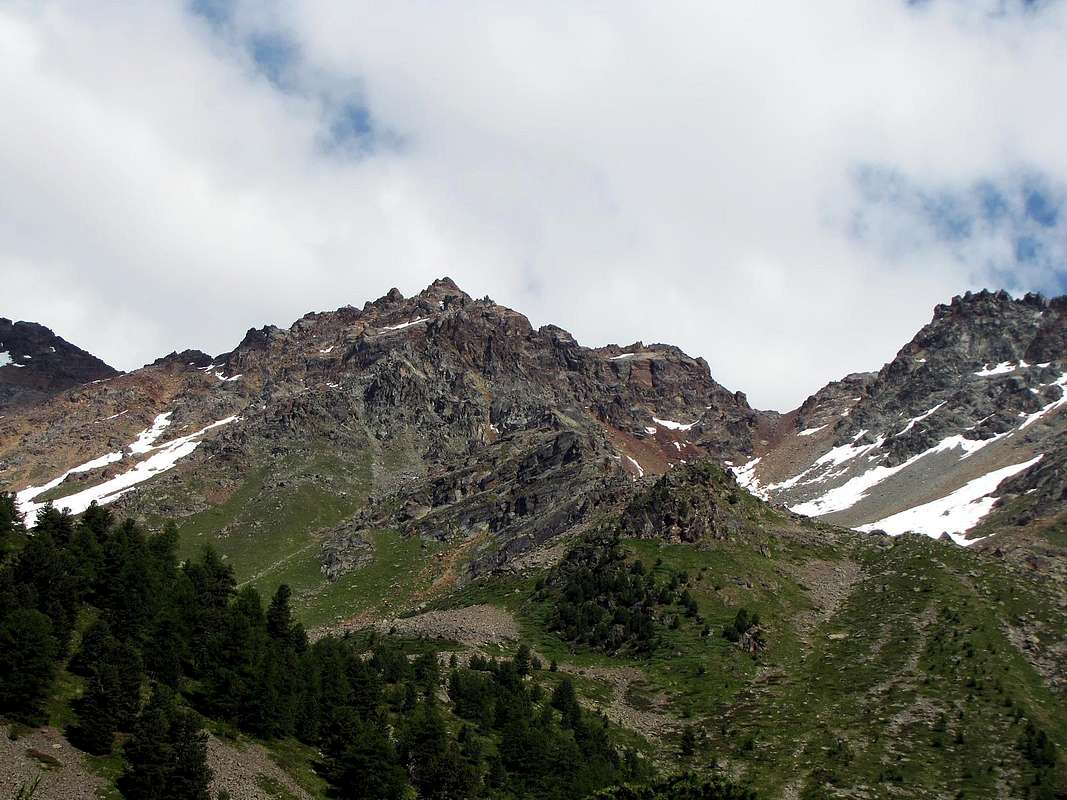 |
C) - Traverse Nona's Becca/Emilius: From Pila
The West-nortwest Ridge to right, by Corvus.
*******
Pila/Chamolé Alpage/Plan Fenetre Hill/Comboé/Plan Valé/Carrel Pass & Federigo Zullo Bivouac/Red Tower 3.150m (delicate free climbing in descent; III°+)/Mount Ròss of Comboé/Little Emilius/Red Towers (IV°- in free)/Mount Emilius; actually "Via Ferrata", since 2004. Return through Standard Route to Arbolle Vallon & Refuge and from this to Pila Resort by the two precedent possibilities (EE up to the Carrel Pass; A on W-NW Ridge; passages of III°+ and IV°- on thread, but in recent times "Via Ferrata", so no evaluation; 8h'00/9h'00).
The Windy West Ridge, by andreaperino.
******* Historical FEATURES
This long ridge, which we have just partially discussed above combines the Mount Emilius the Becca of Nona (3.142m), which is nothing more than its natural topographic projection, after the great window of the Hill Carrel (2.912m), from this top of the watershed, which previously divided the Walloons of Comboé and, to the North, of Arpisson, down steep and abrupt with the "Crestone" North-northeast from that of the last partition Dard below to Comboé. But this hill more that unites the two split peaks, "tying" in an affectionate embrace that the mountaineering history highlights with a series of assemblages, uphill but also in descent, between the two. So talking about the West Ridge, West-northwest in reality, since the first part is turned to the west while the second descending from Mount Ròss on the Hill Carrel with firm direction Northwest, one can not speak of Becca and also the nearby Hill, almost in symbiosis with it. Surely it is less elegant in its lines of North-northeast Edge which projects beyond the North Wall, but longer in its extension, considering the Little Emilius and Mount Ràss of Comboé as part of the same; also its steepness is less conspicuous in the previous year and its most salient features are progressively diluted.
In spite of this, and thus appear more inviting, it is not to have been used continuously for up Emilius, and indeed rope teams that have traveled are a dozen (eleven for the truth of which we have certainty and documentation) to the maximum. The reason? The answer lies in its length, but, above all, in some "barriers" that does not invite the mountaineer, in his analysis from the bottom: the tooth at an altitude of 3.150 meters) (and not as erroneously quoted cards in 3050 metres), a real drawbridge to the entrance to the same, the upper and square red towers and finally a small and grey vertical jump, which will identify here as "Jumping Grey." These, in our opinion, the factors that have experienced visitations scarce and hampered an increased flow. In more than a century, or the first two climbs of 1902, a distance of three days without the other and that the protagonists were aware, until 2004, the year on which it has been equipped by the Mountain Guides, at the initiative of the "Community Monte Emilius ", a Via Ferrata from the hill and up to the peak. But, in truth, his story begins even before, August 30, 1897 or when the roped-Daniele-Devalle, accompanied by two good Mountain Guides of the "Valtornenza" Bich and Pession, caught up in a particular place after the first ascent of the North Face of Emilius with a way not very precise in the description, but that should correspond to the underlying wall to the Little Emilius: " ... the party had to fall back to the right, to the ridge West far below that of the first gendarmes stand on it and that is about fifty meters higher than that sort of hand formed from characteristic projections of the North ridge on the other side of the wall. Therefore followed the crest West towards the right rather holding basin Arbole, until last gendarme returned to the party on the north wall, which had to climb take a long time, because the powdery snow and ice that covered the whole rock and forced again to resume the ascensioners West ridge not far from the summit, however. ... "
But the whole history of this ridge is characterized by broken itineraries here and there, resulting in "loopholes" or circumvention of one or the other side, waiting for, if not complete, at least complete a route. We'll see.
*******
The known ascents (12) on the W-NW Ridge, before the opening of the "Via Ferrata 2004".
Since 1897 until 1999
1) - August 30th, 1897 Giovan Battista Devalle & Ercole Daniele with Valtournanche Mountain Guides Luigi Bich & Alessandro Pession, from terminal part of West Crest, after the first ascent on North Face Little Emilius.
2) - September 16/7, 1902 Abbot Joseph Maria Henry with Charvensod's Mountain Guide Grégoire Comé, in descent from Summit to Little Emilius and from Carrel Hill to Little Emilius.
3) - September 20th, 1902 Felice Mondini & Emilio Questa, directly from Aosta Town and entire Crest.
4) - Winter 1940/1 Nerino Gobbo of Trieste, lone; from Carrel Pass?.
5) - July 20th, 1941 Mountain Guide Adolfo Giulio "Dulo" Ourlaz with the wife, after the ascent on N-NE Edge, in descent to "Becca" and again descent through N-NE "Crestone".
6) - August 01th, 1976 Osvaldo Cardellina & Camillo Roberto Ferronato (Integral Route from "Becca").
7) - July 11th, 1977 Osvaldo Cardellina & Camillo Roberto Ferronato; first ascent from Ròss Pass?.
8) - June 30th, 1985 Alberto Sciardi, lone, in descent after North Wall, Central Couloir.
9) - Summer 1985 or 1986 or 1987 Carlo Lucianaz of Charvensod, lone, in descent after the two N-NE Crest of "Becca" and Emilius.
10) - June 23 th, 1991 Osvaldo Cardellina, solo (from Ròss Pass).
11) - October 06th, 1996 Valpelline Mountain Guide Aldo Cambiolo & Stefano Mottini (from Ròss Pass).
12) - July 24th, 1999 Courmayeur Mountain Guide Pellin with Andreas Meurer of Berlin and Ruggero Pellin.
*******
WEST RIDGE August 1976 "Integral on thread Route"
*******
In 1902 is a first path, but in two times and on two different days, though consecutive 16 September Abbot Henry with his faithful Grégoire Comé before they go to explore the East Ridge, the one that goes down to Les Laures, descending the same and then increased again at the Peak, then, overcome with the desire of conquest, descend along the ridge opposite, the Western. As C.A.I. RM, 1903, pages 73/8: "... First the entire route West ridge, with variation on the South side - remained to explore the West crest up to the Shoulder of Emilius, also known as Little Emilius. Descended for fifty yards obliquely in the direction of said crest, again leaving our photographer to the sun (the Reverend Bionaz Edit Note), in a safe place, we try to fall for it. A white cliff overlooking cut us immediately bar the pace, but we descend for about ten yards to our left, to where a snowy ledge leads horizontally at the foot of that cliff on the edge of the ridge and then we continue to follow. A red rock also cut into 5 meters peak forces us to abandon a second once the ridge for a few meters, after which no more abandon the descending, we can easily bend down over the abyss and contemplating the North wall of Emilius, which with an icy slope and almost perpendicular to 600 m. falls above the glacier of th'Arpisson. continue to descend always keeping us on the cutting edge of the ridge and arrive at the base of the head of Mount Emilius, where the shoulder begins predicted that today we can not go until the end, but that will travel tomorrow. return back but with the difference that instead of redoing the entire ridge, we cut across the mountain on the South side to the top of "Corona's Passage ... " . The next day completed the previously achieved by getting to the point: " ... First ascent of the ridge North-North-West of the Little Emilius. The aim of our race of the day being only 17 Becca of Nona and the Shoulder of Emilius, or Little Emilius, we do not judge necessary to depart so early and even pick up the pace, so swinging on the path ... Comé and I wanted to try the ridge North-North-West from the Hill that Carrel (2.911m) that rises to Shoulder or Little Emilius, which connects the Western ridge of Emilius ... The climb is not difficult it appeared ... But things changed abruptly, two-thirds of the climb, when we already saw near the Shoulder, almost touching it, that's the ridge, there suddenly appeared as a sheer cliff of about twenty yards, so that there was passage. What to do? Return to Colle Carrel was not the case to think about it, it was impossible to continue the ridge. The only solution was groped back down for a while and see if there was no means to overcome the cliff in any other way. This is what we did. Going back down to fifty meters, we crossed on our right towards the Colle Ross and ... ". But just three days after Emilio Questa with Felice Mondini, of the Ligurian Section of the C.A.I., unaware of this climb but giving news earlier in RM, 1902, page 443, go up the ridge day trip from Aosta, passing to Comboé and starting from the Hill Carrel; we spend so in a very short time by a mountaineering exploration to a brilliant achievement, almost sporty. The two in fact accomplish the complete ascent, though not complete, in a single day camp out the Pass of the "Three Capuchins", then the next day in Cogne Mondini goes through the Hills of Arbolle and of Laures, and this goes back to Aosta. A nice firm, nothing to say, worthy of great runners! From this moment on the crest falls by the wayside and you will have to wait until the winter of 1940/41 and July 20, 1941, to attend two other major companies: the first from Trieste Nerino Gobbo, alone, makes the first winter ascent of the ridge and second overall in the winter mountain after the 1934 and in the second the Mountain Guide Giulio Adolfo Ourlaz, called "Dulo", together with his wife (partisan then shot by the Germans) salt Emilius for the North-northeast Edge, falls completely, but not the whole of the West Ridge (private informations had in 1978 by the same Ourlaz), dates back to Becca and descends to the "Crestone" North-northeast. Chapeau to all three! We do not consider the short end sections of the ridge after the various outputs from the North Wall, 1927, 1940, 1942, 1970, 1998 and 2006, and its repetitions, as the route for all is at the end, which is to the East of the "Salto or Jumping Grey." But to get to the real first integral course, everything on the edge of the ridge, including the crossing W/E of the Tooth 3.150 meters or Lower Red Tower, you have to wait for the month of August 1976, where the first day of the same Osvaldo Cardellina and Camillo Roberto Ferronato accomplish this ascent; starting from Pila for Comboé climb to the Col Carrel and the "Becca", descend to the Hill at the Lake Peckoz (Federigo Bivouac, there was not yet), and, in the day, climb the ridge in full: Jag 3.150 meters, Superior Red Towers and "Jump Grey"". All inclusive. The following year, always the same and always in day from Pila, perform the way going up the West Side of the Col Ròss (3.071 m), date back to the ridge to the South-southwest of Mount Ròss inserting and concluding with the previous route. Perhaps it is the first ascent of this ridge, allowing Nerino Gobbo because you do not know his itinerary (check in "Book GARS" of Trieste, not available to us); the same is repeated by Osvaldo Cardellina, alone, June 23, 1991. We also know of two other climbs and a descent of the same by Aldo Cambiolo Mountain Guide and Stefano Mottini (October 06th, 1996), by Pellin (July 24th, 1999) with Andreas Meurer, Berlin and Ruggero Pellin (Society Mountain Guides of Courmayeur) and by Alberto Sciardi,after the solitary climbing on the Center Couloir of the North Wall, (June 30th, 1985) for to join his brother at alternative below the Ròss Pass. Another great traverse, similar to that of Ourlaz July 1941, is performed by the talented Carlo Lucianaz of Charvensod that in one of the three Summers 07.06.1985 (Aih, memory!) Salt the "Crestone" North-northeast of "Becca", through the two Arpisson's Glaciers, salt to Emilius for the North-northeast Edge, go down the West ridge and falls in Charvensod. Not bad!. Then nothing. Since 2004 is installed "Via Ferrata" and with it disappears, as in the Normal Dente del Gigante, one of the ridges of the Lion and Hörnli the Matterhorn and other mountains, forever the "Old way of Emilius". The rest does not interest us, although in the "Third Part of 33 ROUTES" we have given an account of, for the record, the first 22 ascents Lonely on this path. But it is another thing ...
*******
Questa lunga cresta, della quale abbiamo parzialmente appena sopra parlato, unisce il Monte Emilius alla Becca di Nona (3.142 m), che altro non é che la sua naturale proiezione topografica, dopo la grande finestra del Colle Carrel (2.912 m); da questa vetta lo spartiacque, che prima divideva i Valloni di Comboé ed, a Settentrione, di Arpisson, scende dirupato ed abrupto con il Crestone Nord-nordest divisorio l'ultimo da quello del Dard, sottostante quello di Comboé. Ma codesto colle più che divider unisce le due cime, "legandole" in un abbraccio affettuoso che la storia alpinistica evidenzia con una serie di concatenamenti, in salita ma anche in discesa, tra le due. Così parlando della Cresta Ovest, in realtà Ovest-nord ovest, poiché il primo tratto é rivolto ad Occidente mentre il secondo scende dal Mont Ròss sopra il Colle Carrel con decisa direzione Nordovest, non si può non parlare inoltre della Becca e del vicino Colle, quasi in simbiosi con la stessa. Sicuramente é meno elegante nelle sue linee dello Spigolo Nord-nordest, che si proietta al di là della Parete Nord, ma più lunga nella sua estensione, considerando il Piccolo Emilius ed il Mont Ròss de Comboé come facenti parte della medesima; anche la sua ripidezza risulta meno vistosa del precedente ed i suoi tratti maggiormente in evidenza sono diluiti progressivamente.
Nonostante ciò e, quindi l'apparire più invitante, non é che sia stata utilizzata in modo continuativo per salire l'Emilius; anzi le cordate che l'hanno percorsa sono una dozzina (undici per la verità delle quali si ha certezza e documentazione) al massimo. Il motivo? La risposta sta nella sua lunghezza, ma, e soprattutto, in alcuni "sbarramenti" che non invitano l'alpinista, in una sua analisi dal basso: il dente a quota 3150 metri circa (e non come erroneamente quotato nelle Carte 3050 m), vero ponte levatoio per l'ingresso alla medesima, le superiori e squadrate rosse torri ed infine un piccolo salto verticale, che qui individueremo come "Salto Grigio". Questi, a nostro avviso, i fattori che hanno fatto registrare scarse visitazioni ed ostacolato un maggior afflusso. In più d'un secolo, ovvero dalle due prime salite del 1902, una a distanza di tre giorni dall'altra e senza che i protagonisti ne fossero a conoscenza, fino al 2004, anno sulla quale é stata attrezzata dalle Guide, su iniziativa della "Comunità Monte Emilius", una Via Ferrata dal colle a raggiunger la Vetta. Ma, per la verità, la sua storia s'inizia ancor prima, ovvero quando il 30 Agosto 1897 la cordata Devalle-Daniele, accompagnata dalle due brave Guide della "Valtornenza" Bich e Pession, la raggiunse in un punto ben determinato dopo aver effettuato la prima salita della Parete Nord dell'Emilius con una via non molto precisa nella descrizione, ma che dovrebbe corrispondere alla parete sottostante al Piccolo Emilius: " ... la comitiva dovette ripiegare a destra, portandosi sulla cresta Ovest assai aldisotto dei primi gendarmi che sorgono su di essa e cioé ad una cinquantina di metri circa più in alto di quella specie di mano formata da caratteristici spuntoni della cresta Nord dall'altra parte della parete. Seguì quindi la cresta Ovest tenendosi piuttosto verso il bacino di Arbole, finché all'ultimo gendarme la comitiva ritornò sulla parete Nord, a scalare la quale dovette impiegare molto tempo, causa la neve farinosa ed il ghiaccio che ricopriva la roccia tutta e che costrinse di nuovo gli ascensionisti a riprendere la cresta Ovest non lungi però dalla vetta. ... "
Ma tutta la storia di questa cresta é caratterizzata da percorsi interrotti qua e là con conseguenti "scappatoie" od aggiramenti su di uno o l'altro versante, in attesa di, se non integrale, un tracciato almeno completo. Lo vedremo.
Nel 1902 avviene un primo percorso, ma in due tempi ed in due giorni diversi, se pur consecutivi; il 16 Settembre l'Abate Henry con la sua fida Grégoire Comé prima vanno ad esplorare la Cresta Est, quella che scende verso Les Laures, scendendola e poi risalendo nuovamente in Vetta; quindi, presi dal desiderio di conquista, scendono lungo la Cresta opposta, ovvero la Ovest. Come da RM C.A.I. 1903, pagine 73/8: " ... Primo percorso dell'intera cresta Ovest, con variante sul versante Sud. - Rimaneva da esplorare la cresta Ovest fino alla Spalla dell'Emilius, detta anche Piccolo Emilius. Discesi per una cinquantina di metri obliquamente nel senso di detta cresta, lasciando nuovamente il nostro fotografo al sole (il Reverendo Bionaz N.d.R.), in luogo sicuro, proviamo a calare per essa. Una rupe bianca tagliata a picco ci sbarra subito il passo, ma noi discendiamo per una decina di metri sulla nostra sinistra, fin dove una cengia nevosa ci porta orizzontalmente ai piedi di detta rupe e quindi sul filo della cresta che continuiamo a seguire. Una rupe rossa pure tagliata a picco per 5 metri ci obbliga ad abbandonare una seconda volta la cresta per alcuni metri; in seguito non l'abbandoneremo più discendendo, possiamo facilmente chinarci sopra l'abisso e contemplare la parete Nord dell'Emilius, che con un pendio ghiacciato e quasi perpendicolare di 600 m. cade sopra il ghiacciaio d'Arpisson. Continuiamo a discendere tenendoci sempre sul tagliente della cresta e giungiamo alla base della testa del Monte Emilius, là dove comincia la Spalla predetta, che oggi noi non possiamo percorrere fino all'estremità, ma che percorreremo domani. Ritorniamo indietro ma colla differenza che, invece di rifare tutta la cresta, tagliamo trasversalmente la montagna sul versante Sud fino alla sommità del "Passaggio Corona ... ". Il giorno appresso completarono la via arrivando al punto precedentemente raggiunto: " ... Primo percorso della cresta Nord-Nord-Ovest del Piccolo Emilius. Scopo della nostra corsa del giorno 17 non essendo che la Becca di Nona e la Spalla dell'Emilius, o Piccolo Emilius, non giudichiamo necessario di partir tanto di buon ora e neppure di accelerare il passo, così dondolandoci per il sentiero ... Io e Comé volevamo provare la cresta Nord-Nord-Ovest che dal Colle Carrel (2.911 m) sale a detta Spalla, o Piccolo Emilius, al quale si collega la cresta Ovest dell'Emilius ... La salita non presentavasi difficile ... Ma la faccenda cambiò bruscamente; ai due terzi della salita, quando già vedevamo vicina la Spalla, quasi da toccarla, ecco che la cresta ci presentò subitamente come un dirupo a picco d'una ventina di metri, così da sbarrarci il passaggio. Che fare? Ritornare al Colle Carrel non era il caso di pensarci; continuare per la cresta era impossibile. Unica soluzione da tentarsi era ridiscendere per un tratto e vedere se non c'era mezzo di superare il dirupo per altra via. Questo é quanto facemmo. Ridiscesi per una cinquantina di metri, attraversammo sulla nostra destra in direzione del Colle Ross e ...". Ma solo tre giorni dopo Emilio Questa e Felice Mondini della Sezione Ligure del C.A.I., ignari di questa salita ma dando notizia in precedenza in RM 1902, pagina 443, salgono la cresta in giornata partendo da Aosta, transitando al Comboé ed iniziando dal Colle Carrel; passiamo così in un tempo molto breve da un alpinismo di esplorazione ad un bel exploit, quasi sportivo. I due infatti compiono la salita completa, anche se non integrale, in un solo giorno; bivaccano al Passo dei "Tre Cappuccini", quindi il giorno appresso Mondini se ne va a Cogne tramite i Colli di Arbolle e des Laures, mentre Questa ritorna ad Aosta. Una bella impresa, niente da dire; degna di ottimi maratoneti! Da questo momento la cresta ricade nel dimenticatoio e si dovrà attendere l'inverno del 1940/41 ed il 20 Luglio del 1941, per assistere ad altre due imprese significative: nella prima il triestino Nerino Gobbo, da solo, compie la prima invernale della cresta, nonché seconda assoluta invernale della montagna dopo quella del 1934; nella seconda la Guida Giulio Adolfo Ourlaz, detto "Dulo", insieme alla moglie (partigiana poi fucilata dai tedeschi) sale l'Emilius per lo Spigolo Nord-nordest, scende completamente, ma non integralmente, la Cresta Ovest (informazioni private avute nel 1978 dallo stesso Ourlaz), risale alla Becca e scende per il Crestone Nord-nordest. Chapeau per tutti e tre!
Non consideriamo i brevi tratti terminali della cresta dopo le varie uscite dalla Parete Nord del 1927, 1940, 1942, 1970, 1998 e 2006 e relative ripetizioni, poiché il percorso per tutte avviene nella parte finale, ovvero ad Est del cosiddetto "Salto Grigio". Ma per arrivare al vero primo percorso integrale, tutto sul filo di cresta, compresa la traversata O/E del Dente 3.150 metri o Torre Rossa Inferiore, si deve attendere il mese d'Agosto 1976, dove nel primo giorno dello stesso Osvaldo Cardellina e Camillo Roberto Ferronato compiono questa ascensione; partendo da Pila per il Comboé salgono al Colle Carrel ed alla "Becca", ridiscendono al Colle, presso il Laghetto Peckoz (il Bivacco Federigo non c'era ancora) e, sempre in giornata, salgono la cresta integralmente: Dente Inferiore a 3.150 metri, Torri Rosse Superiori e "Salto Grigio". Tutto compreso. L'anno successivo, sempre gli stessi e sempre in giornata da Pila, compiono la via salendo il Versante Ovest del Col Ròss (3071 m), risalgono per la Cresta Sud-sudovest al Mont Ròss inserendosi e concludendo con la precedente via. Forse é la prima ascensione da questa cresta, Nerino Gobbo permettendo perché non si conosce il suo itinerario (controllare in "Libro GARS" di Trieste, non a nostra disposizione); la stessa viene ripetuta da Osvaldo Cardellina, da solo, il 23 Giugno 1991. Sappiamo ancora di altre due salite ed una discesa della stessa da parte delle Guide Aldo Cambiolo e Stefano Mottini (6 Ottobre, 1996), Pellin il 24 Luglio, 1999 con Andreas Meurer, di Berlino, e Ruggero Pellin (Società Guide di Montagna di Courmayeur) e di Alberto Sciardi, dopo aver salito il Canale Centrale della Nord il 30 di Giugno del 1985, per raggiungere il fratello al bivio sott'al Col Ròss. Un'altra grande attraversata, similare a quella di Ourlaz del Luglio '41, viene compiuta dal bravo Carlo Lucianaz di Charvensod, che in una delle tre Estati 1985/6/7/ (Aih, la memoria!) sale il Crestone Nord-nordest della "Becca, attraversa i due Ghiacciai di Arpisson, sale all'Emilius per lo Spigolo Nord-nordest, scende per la cresta Ovest e rientra a Charvensod. Niente male!. Poi più nulla. Dal 2004 viene installata la Via Ferrata e con essa scompare, come per la Normale al Dente del Gigante, quella delle Creste del Leone e dell'Hornli al Cervino e per altre montagne, per sempre la "Vecchia Via dell'Emilius. Il resto non ci interessa, anche se nella "Terza Parte di 33 ROUTES" abbiamo dato un resoconto, per dover di cronaca, delle prime 22 ascensioni in Solitaria su questo percorso. Ma é tutta un'altra cosa...
*******
D)- Crossing Mount Père Laurent/Emilius: from Regional Pila's Road/
Rayer of TzaT/Reverier Dessous or Lower/Rongachet's small Bridge, between Charvensod-Pollein Municipalities/Rongachet Village/Martsaouchy Desott, du Meitin and Dessus (1h'15/1h'30) Alpages/Plan Croix Old Alp (ruines)/Arpisson's Wallon with Lower and Upper Pastures/Western Face of Mount Père Laurent (2h'30/2h'45)/ Points & Becca of Seneva through N-NW Ridge (passages of II°/II°+ on thread with one of III°-)/Peckoz Pass/Testa Blantsette & Carving/NE Crest of Black Triangle and N Edge of Emilius (3h'30/4h'00; 12h'30/13h'30).
*******
The Wild Watershed amongst Arpisson (in bottom) & Laures Vallons
*******
Historical FEATURES
of which we have just discussed above, paradoxically, was first climbed in his most difficult part (N-NE Edge, 1906) and later in the simplest (N-NW Ridge of Becca Seneva, 1924), but other traits, the ascent of Mount Père Laurent, Peckoz Pass, Head Blantsette and nearby Carving Blantsette's Pass were visited and frequented "ab immemorabilis" by shepherds and hunters, forming the famous "Passer the Cordagnì" with which the latter they identified and signaled a definite place hunting, always well heeled by Gamekeepers of Baron Beck Peckoz, Walser originally from Valley of Gressoney, who guarded these vallons and that of Grauson-Lussert up to the current Grauson New (Hunting Houses in Mulac-Saint Louis, Greate Chaux, small refuge under the Carrel Hill, now completely destroyed and rebuilt, and still in the Grande Chaux in Grauson Walloon, corresponding to the current New Grauson. Seneva the normal route to (S Crest, after having climbed the O Face, 1897) instead was "up down", by the rope of 30 August, which came to Col Peckoz to get off on both Eastern and Western Glaciers of th'Arpisson with the intent to observe the still virgin on which North Face of Emilius, the next day, make an attempt to uphill. But almost certainly, this part of the ridge, incidentally easy, had already been beaten by Guards Hunting Reserve Peckoz, wherefore to Daniele Devalle with the two Mountain Guides of Valtournanche Bich and Pession is nothing more than the first climbing mountaineering note. There was still a short section of ridge to explore, what Renato Chabod with two companions, G. Riconda and A. Nouchy, had escaped, or between Mount Père Laurent and the onset of North-northwest Ridge rising from them: "... June 15, 1924, on the opposite side of the Combe of Arpisson, reaching the crest of Père Laurent-Becca of Seneva a hundred yards South of the Père Laurent and then continuing along the ridge to the Becca Seneva. remember a pleasant dihedral with crack, excellent gray gneiss and the long descent to Quart Villefranche, through the lakes Laures. ". We went to remove the '"footprint" July 20, 1978 when with my son Christian (5 years!) and Professor Giorgio Fruttaz, starting from Martsaouchy and, this time, to the Valley of Arpisson, we went first to the Père Laurent (2.625m ) and then cross, return, those three small tops (2646m, the highest South Point, even if only slightly), the surprise was that at the top of the first, between an unbearable stench, we found a dozen dead sheep. Exposing us to the big jump to the East, we saw the rest of the flock, smashed on stony ground below. The storm had driven up there and missed the first one, all the others had gone behind. As in the famous painting "of the blind", by Bruegel, if I'm not mistaken. We covered so that little more than a hundred yards that were missing, among broken rocks and covered with dangerous and treacherous grass "Ollina".
del quale abbiamo giusto sopra trattato, paradossalmente é stato salito dapprima nella sua parte più difficile (Spigolo N-NE,m 1906) e successivamente in quella più semplice (Cresta N-NW della Becca Seneva, 1924); ma gli altri tratti, ovverossia salita del Mont Père Laurent, Col Peckoz, Testa Blantsette e vicino Intaglio o Colle Blantsette erano stati visitati e frequentati "ab immemorabilis" da pastori e cacciatori, costituendo il famoso "Passer lo Cordagnì" con i quale questi ultimi individuavano e segnalavano un preciso luogo di caccia, sempre ben tallonati dai Guardiacaccia del Barone Beck Peckoz, Walser originario della Valle di Gressoney, che presidiavano questi valloni e quello del Grauson-Lussert fino all'attuale Grauson Nuove (Case di Caccia a Mulac-Saint Louis, Grande Chaux, piccolo rifugio sotto al Colle Carrel, andato distrutto ed oggi completamente ricostruito, ed ancora di Grande Chaux nel Grauson, corrispondente all'attuale Grauson Nuove. La via normale alla Seneva (Cresta S, dopo la salita per la Faccia O, 1897) invece fu "salita in discesa" dalla cordata del 30 Agosto, che giunse al Col Peckoz per quindi discendere sui due Ghiacciai Orientale ed Occidentale di Arpisson con l'intento di osservar l'ancor vergine Parete Nord dell'Emilius sulla quale, il giorno appresso, effettuarne un tentativo di salita. Ma quasi sicuramente, questo tratto di cresta, daltronde facile, era già stato battuto dalle Guardie di Caccia della Riserva Peckoz, per la qual cosa quella di Devalle-Daniele con le due Guide di Valtournanche Bich e Pession altri non é che la prima ascensione alpinistica nota. Rimaneva ancora un breve tratto incognito di cresta da esplorare, quello che Renato Chabod con i due compagni, G. Riconda ed A. Nouchy, aveva evitato, ovvero tra il Mont Père Larent e l'inizio della Cresta Nord-nordovest da loro salita: " ... il 15 Giugno 1924, sull'opposto versante della Comba di Arpisson, raggiungendo la cresta Père Laurent-Becca di Seneva un centinaio di metri più a sud del Père Laurent e poi continuando per cresta fino alla Becca di Seneva. Ricordo un piacevole diedro con fessura, di ottimo gneiss grigiastro, nonché la lunga discesa fino a Quart Villefranche, passando per i laghi di Laures.". Andammo a togliere l'"ingombro" il 20 Luglio 1978 quando con mio figlio Christian (5 anni!) ed il Professor Giorgio Fruttaz, partendo da Martsaouchy e, questa volta, per il Vallone di Arpisson, salimmo dapprima al Père Laurent (2.625 m) per poi attraversare, andata e ritorno, quelle tre puntine (2.646 m, la Punta Sud più elevata, anche se di poco); la sorpresa fu che in vetta al primo, tra un fetore insopportabile, trovammo una decina di pecore morte. Esponendoci sul grande salto ad Est, vedemmo tutto il resto del gregge, sfracellato sulla sottostante pietraia. Il temporale le aveva spinte fin lassù e, saltata la prima, tutte le altre le erano andate dietro. Come nel famoso quadro "del cieco" di Bruegel, se non sbaglio. Così coprimmo quel poco più di un centinaio di metri che mancavano all'appello, tra rocce rotte e ricoperte da pericolosa ed infida erba "ollina".
E) - Traverse Peak Garin/Mount Emilius: from Pila
Three Summits of Emilius's Red Points & Northeast Crest to (centrally) Arbolle's Hill. Left South-southeast Crest to Laures's Point
*******
Pila Resort/ Chamolé Lake & Hill/Arblole Vallon with two Lochs and Refuge (T/E; 2h'15/2h'30)/Garin Pass & Lake (EE; 3h'30/4h'00)/Garin Peak through Southwest on NorthWest and Nord Edge (better; I°; II°+ and III°- on thread, more amusing)/crossing to Mount Valaisan & Pass (A; 7h'00/7h'30)/Emilius Three Red Points/Arbolle Hill/Point of Three Capuchins & Pass/Emilius (A; 10h'00/10h'30) . Return through same route passing Fozen Loch (EE/A; 12h'00/14h'00).
From Gimillan Hamlet: /Arpisson Vallon & Pasture/Plan Bessey Tableland/Franco Nebbia Bivouac/Garin Lake and same two precedent routes (EE/A; same times).
*******
Historical FEATURES
After a taste of Agostino Ferrari, going in the opposite direction from the Col d'Arbolle (3.154m), with the Mountain Carrier of Cogne B. Glarey September 14th, 1898 that perform the crossing Emilius Red Points-Peak Garin (the day after will make the crossing of Roises), this oceanic traverser could only be carried out by the "camel" Dr. Anselme "Ansel" Falcoz (Dent Blanche for "Crest of the Four Donkeys", by bike (the Thirties extremely heavy and the "brakes" plunger!) from Aosta, round trip, passing the Great Saint Bernard Hill!!!). In the Month of August 1936 from his home in our part Fernier, quite a bit to the Western of Pila, go to Chamolé Lake, crosses the hill, go to Arbolle, "burn" even the Garin Hill, surpasses the lake, up to the Garin Peak (how many Sometimes he climb?: "An infinity!" he tells me in 1978 telling his adventures with fun and joy, despite a problem with one eye and amputation for a tumor in his leg, "But skied anyway. Except that once I escaped the prosthesis and skiers of Pila were terrified by the sight of come down a ski coming down from above with only half a leg". This was Dr."Ansel", which gave me to keep his story of war, which I still have in a drawer. I would like to return it, but his family does not exist anymore. Or almost. So by Garin falls Mount Valaisan, the next hill or Pas, "dribble" the three Points Red, falls below Arbolle's Pass, round the Point of the "Three Capuchins", which then had no name, comes homonymous pass and still the same name Cresta or South-southwest it "lays" on Emilius. Fernier Then come back to. All in one daily. After the first winter at Point Garin (on Christmas Day of '36, with his brother Pierluigi, called "Piero" and those solitary the Grauson Tower (5/6/7 February '39), and, in the same winter in the middle of World War II, the three Summits of Emilius's Red Points (11/12 March 1939), we find him in 1940, where the Professor of Turin Massimo Mila go up the Central Couloir on the North Emilius: "We ascended so well together regularly and that we refer the time to tie using the rope, that we forgot arriving on the West Ridge and then on top without using it. Or July 5, 1964, when he left the chute on the North Wall of the Summit East of the Red Points with Giorgio Mondini and the dog Kalì (business found me in August of '75, in a small box of rusty meat under a rock.) But the Doctor the "camel" of '36 was not enough and so in the Summer of 1947, the war is now terminated, tries again. They stop the pass of "Three Capuchins" of his companions, he said, "defeatists." We (the undersigned with Marco Cossard aka "Crevassino" and Joseph Lamazzi, said "The Peppino", stimulated the imagination, June 29, 1976 (on the Day of Peter and Paul and of Fires over th'Emilius) can not be outdone. Even so we, who as a "camel" we are second to anyone, we are following in the footsteps of Dr. Falcoz. All in a day, but from Pila, a little closer to that Fernier. Though, from "Purists", also cross the Top of the "Three Capuchins", which was then still unknown Quote IGM 3.283 meters, not bad: start at 7 '00, arrival to the Summit at around 19'00 (granting of various stops for about 2h'00), meeting with the Band Brissogne, led by Giovanni Matteo Zulian, said " Augustine " and inevitable Fireworks show with the fires, in the dark, the light suggestively Emilius. Then, everybody goes ... We remain Guido Allegri Charvensod and I to make the bivouac, "in full nature", ie nothing. Makes even hot and we get stuck between two rocks red (what an idiot, all the rocks are red in Emilius!). Night brings counsel, and so we fall asleep peacefully. Halfway through the same powerful rumble of thunder wakes us up, along with the first drops. Damn, we do not have the lights, not batteries, not even a candle, indeed Guido (who died last year), which is a smoker, has the lighter. Racing doooown the ridge, so it is brightly lit by lightning! It is an apocalyptic scene. Missing only one camera to film these two shapes "spinning", which stand out against the burning sky jumping from boulder to boulder, like a ride of the Valkyries, appearing and disappearing for a moment between a lightning strike and another.
But the next day at 7 '00 are home to go to the pool to work. It must have been a Dream, a little nice and a little ugly!
Who wants to try again, trrrry ...
*******
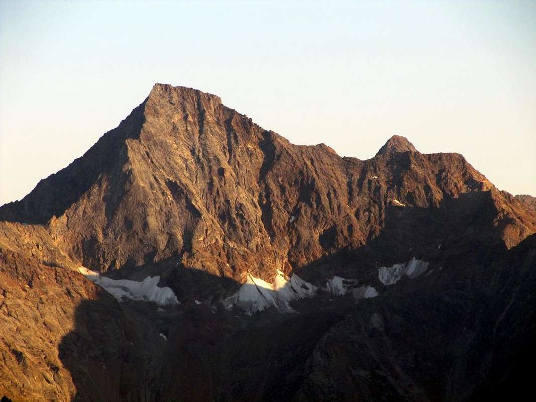 |
Pila/Chamolé Alpage/Plan Fenetre Hill/Comboé/Plan Valé/Carrel Pass & Federigo Zullo Bivouac/Red Tower 3.150m (delicate free climbing in descent; III°+)/Mount Ròss of Comboé/Little Emilius/Red Towers (IV°- in free)/Mount Emilius; actually "Via Ferrata", since 2004. Return through Standard Route to Arbolle Vallon & Refuge and from this to Pila Resort by the two precedent possibilities (EE up to the Carrel Pass; A on W-NW Ridge; passages of III°+ and IV°- on thread, but in recent times "Via Ferrata", so no evaluation; 8h'00/9h'00).
 |
This long ridge, which we have just partially discussed above combines the Mount Emilius the Becca of Nona (3.142m), which is nothing more than its natural topographic projection, after the great window of the Hill Carrel (2.912m), from this top of the watershed, which previously divided the Walloons of Comboé and, to the North, of Arpisson, down steep and abrupt with the "Crestone" North-northeast from that of the last partition Dard below to Comboé. But this hill more that unites the two split peaks, "tying" in an affectionate embrace that the mountaineering history highlights with a series of assemblages, uphill but also in descent, between the two. So talking about the West Ridge, West-northwest in reality, since the first part is turned to the west while the second descending from Mount Ròss on the Hill Carrel with firm direction Northwest, one can not speak of Becca and also the nearby Hill, almost in symbiosis with it. Surely it is less elegant in its lines of North-northeast Edge which projects beyond the North Wall, but longer in its extension, considering the Little Emilius and Mount Ràss of Comboé as part of the same; also its steepness is less conspicuous in the previous year and its most salient features are progressively diluted.
But the whole history of this ridge is characterized by broken itineraries here and there, resulting in "loopholes" or circumvention of one or the other side, waiting for, if not complete, at least complete a route. We'll see.
Since 1897 until 1999
1) - August 30th, 1897 Giovan Battista Devalle & Ercole Daniele with Valtournanche Mountain Guides Luigi Bich & Alessandro Pession, from terminal part of West Crest, after the first ascent on North Face Little Emilius.
2) - September 16/7, 1902 Abbot Joseph Maria Henry with Charvensod's Mountain Guide Grégoire Comé, in descent from Summit to Little Emilius and from Carrel Hill to Little Emilius.
3) - September 20th, 1902 Felice Mondini & Emilio Questa, directly from Aosta Town and entire Crest.
4) - Winter 1940/1 Nerino Gobbo of Trieste, lone; from Carrel Pass?.
5) - July 20th, 1941 Mountain Guide Adolfo Giulio "Dulo" Ourlaz with the wife, after the ascent on N-NE Edge, in descent to "Becca" and again descent through N-NE "Crestone".
6) - August 01th, 1976 Osvaldo Cardellina & Camillo Roberto Ferronato (Integral Route from "Becca").
7) - July 11th, 1977 Osvaldo Cardellina & Camillo Roberto Ferronato; first ascent from Ròss Pass?.
8) - June 30th, 1985 Alberto Sciardi, lone, in descent after North Wall, Central Couloir.
9) - Summer 1985 or 1986 or 1987 Carlo Lucianaz of Charvensod, lone, in descent after the two N-NE Crest of "Becca" and Emilius.
10) - June 23 th, 1991 Osvaldo Cardellina, solo (from Ròss Pass).
11) - October 06th, 1996 Valpelline Mountain Guide Aldo Cambiolo & Stefano Mottini (from Ròss Pass).
12) - July 24th, 1999 Courmayeur Mountain Guide Pellin with Andreas Meurer of Berlin and Ruggero Pellin.
WEST RIDGE August 1976 "Integral on thread Route"
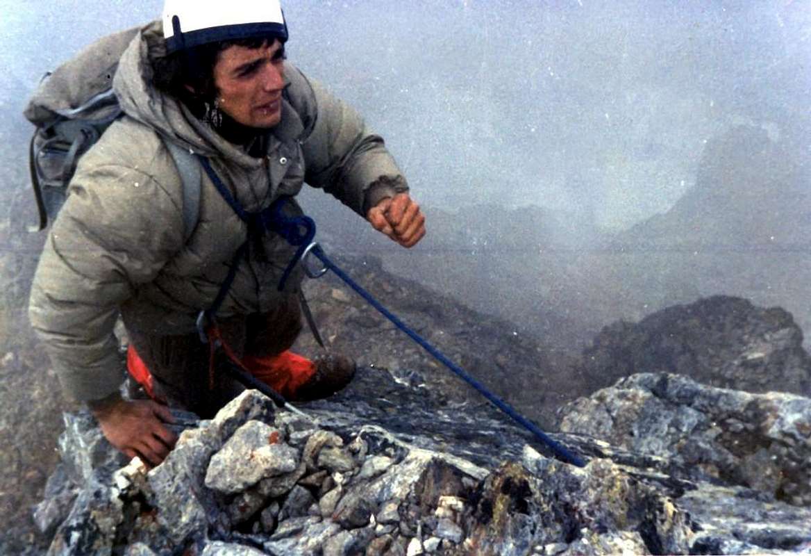 |
In 1902 is a first path, but in two times and on two different days, though consecutive 16 September Abbot Henry with his faithful Grégoire Comé before they go to explore the East Ridge, the one that goes down to Les Laures, descending the same and then increased again at the Peak, then, overcome with the desire of conquest, descend along the ridge opposite, the Western. As C.A.I. RM, 1903, pages 73/8: "... First the entire route West ridge, with variation on the South side - remained to explore the West crest up to the Shoulder of Emilius, also known as Little Emilius. Descended for fifty yards obliquely in the direction of said crest, again leaving our photographer to the sun (the Reverend Bionaz Edit Note), in a safe place, we try to fall for it. A white cliff overlooking cut us immediately bar the pace, but we descend for about ten yards to our left, to where a snowy ledge leads horizontally at the foot of that cliff on the edge of the ridge and then we continue to follow. A red rock also cut into 5 meters peak forces us to abandon a second once the ridge for a few meters, after which no more abandon the descending, we can easily bend down over the abyss and contemplating the North wall of Emilius, which with an icy slope and almost perpendicular to 600 m. falls above the glacier of th'Arpisson. continue to descend always keeping us on the cutting edge of the ridge and arrive at the base of the head of Mount Emilius, where the shoulder begins predicted that today we can not go until the end, but that will travel tomorrow. return back but with the difference that instead of redoing the entire ridge, we cut across the mountain on the South side to the top of "Corona's Passage ... " . The next day completed the previously achieved by getting to the point: " ... First ascent of the ridge North-North-West of the Little Emilius. The aim of our race of the day being only 17 Becca of Nona and the Shoulder of Emilius, or Little Emilius, we do not judge necessary to depart so early and even pick up the pace, so swinging on the path ... Comé and I wanted to try the ridge North-North-West from the Hill that Carrel (2.911m) that rises to Shoulder or Little Emilius, which connects the Western ridge of Emilius ... The climb is not difficult it appeared ... But things changed abruptly, two-thirds of the climb, when we already saw near the Shoulder, almost touching it, that's the ridge, there suddenly appeared as a sheer cliff of about twenty yards, so that there was passage. What to do? Return to Colle Carrel was not the case to think about it, it was impossible to continue the ridge. The only solution was groped back down for a while and see if there was no means to overcome the cliff in any other way. This is what we did. Going back down to fifty meters, we crossed on our right towards the Colle Ross and ... ". But just three days after Emilio Questa with Felice Mondini, of the Ligurian Section of the C.A.I., unaware of this climb but giving news earlier in RM, 1902, page 443, go up the ridge day trip from Aosta, passing to Comboé and starting from the Hill Carrel; we spend so in a very short time by a mountaineering exploration to a brilliant achievement, almost sporty. The two in fact accomplish the complete ascent, though not complete, in a single day camp out the Pass of the "Three Capuchins", then the next day in Cogne Mondini goes through the Hills of Arbolle and of Laures, and this goes back to Aosta. A nice firm, nothing to say, worthy of great runners! From this moment on the crest falls by the wayside and you will have to wait until the winter of 1940/41 and July 20, 1941, to attend two other major companies: the first from Trieste Nerino Gobbo, alone, makes the first winter ascent of the ridge and second overall in the winter mountain after the 1934 and in the second the Mountain Guide Giulio Adolfo Ourlaz, called "Dulo", together with his wife (partisan then shot by the Germans) salt Emilius for the North-northeast Edge, falls completely, but not the whole of the West Ridge (private informations had in 1978 by the same Ourlaz), dates back to Becca and descends to the "Crestone" North-northeast. Chapeau to all three! We do not consider the short end sections of the ridge after the various outputs from the North Wall, 1927, 1940, 1942, 1970, 1998 and 2006, and its repetitions, as the route for all is at the end, which is to the East of the "Salto or Jumping Grey." But to get to the real first integral course, everything on the edge of the ridge, including the crossing W/E of the Tooth 3.150 meters or Lower Red Tower, you have to wait for the month of August 1976, where the first day of the same Osvaldo Cardellina and Camillo Roberto Ferronato accomplish this ascent; starting from Pila for Comboé climb to the Col Carrel and the "Becca", descend to the Hill at the Lake Peckoz (Federigo Bivouac, there was not yet), and, in the day, climb the ridge in full: Jag 3.150 meters, Superior Red Towers and "Jump Grey"". All inclusive. The following year, always the same and always in day from Pila, perform the way going up the West Side of the Col Ròss (3.071 m), date back to the ridge to the South-southwest of Mount Ròss inserting and concluding with the previous route. Perhaps it is the first ascent of this ridge, allowing Nerino Gobbo because you do not know his itinerary (check in "Book GARS" of Trieste, not available to us); the same is repeated by Osvaldo Cardellina, alone, June 23, 1991. We also know of two other climbs and a descent of the same by Aldo Cambiolo Mountain Guide and Stefano Mottini (October 06th, 1996), by Pellin (July 24th, 1999) with Andreas Meurer, Berlin and Ruggero Pellin (Society Mountain Guides of Courmayeur) and by Alberto Sciardi,after the solitary climbing on the Center Couloir of the North Wall, (June 30th, 1985) for to join his brother at alternative below the Ròss Pass. Another great traverse, similar to that of Ourlaz July 1941, is performed by the talented Carlo Lucianaz of Charvensod that in one of the three Summers 07.06.1985 (Aih, memory!) Salt the "Crestone" North-northeast of "Becca", through the two Arpisson's Glaciers, salt to Emilius for the North-northeast Edge, go down the West ridge and falls in Charvensod. Not bad!. Then nothing. Since 2004 is installed "Via Ferrata" and with it disappears, as in the Normal Dente del Gigante, one of the ridges of the Lion and Hörnli the Matterhorn and other mountains, forever the "Old way of Emilius". The rest does not interest us, although in the "Third Part of 33 ROUTES" we have given an account of, for the record, the first 22 ascents Lonely on this path. But it is another thing ...
 |
 |
 |
Questa lunga cresta, della quale abbiamo parzialmente appena sopra parlato, unisce il Monte Emilius alla Becca di Nona (3.142 m), che altro non é che la sua naturale proiezione topografica, dopo la grande finestra del Colle Carrel (2.912 m); da questa vetta lo spartiacque, che prima divideva i Valloni di Comboé ed, a Settentrione, di Arpisson, scende dirupato ed abrupto con il Crestone Nord-nordest divisorio l'ultimo da quello del Dard, sottostante quello di Comboé. Ma codesto colle più che divider unisce le due cime, "legandole" in un abbraccio affettuoso che la storia alpinistica evidenzia con una serie di concatenamenti, in salita ma anche in discesa, tra le due. Così parlando della Cresta Ovest, in realtà Ovest-nord ovest, poiché il primo tratto é rivolto ad Occidente mentre il secondo scende dal Mont Ròss sopra il Colle Carrel con decisa direzione Nordovest, non si può non parlare inoltre della Becca e del vicino Colle, quasi in simbiosi con la stessa. Sicuramente é meno elegante nelle sue linee dello Spigolo Nord-nordest, che si proietta al di là della Parete Nord, ma più lunga nella sua estensione, considerando il Piccolo Emilius ed il Mont Ròss de Comboé come facenti parte della medesima; anche la sua ripidezza risulta meno vistosa del precedente ed i suoi tratti maggiormente in evidenza sono diluiti progressivamente.
Nonostante ciò e, quindi l'apparire più invitante, non é che sia stata utilizzata in modo continuativo per salire l'Emilius; anzi le cordate che l'hanno percorsa sono una dozzina (undici per la verità delle quali si ha certezza e documentazione) al massimo. Il motivo? La risposta sta nella sua lunghezza, ma, e soprattutto, in alcuni "sbarramenti" che non invitano l'alpinista, in una sua analisi dal basso: il dente a quota 3150 metri circa (e non come erroneamente quotato nelle Carte 3050 m), vero ponte levatoio per l'ingresso alla medesima, le superiori e squadrate rosse torri ed infine un piccolo salto verticale, che qui individueremo come "Salto Grigio". Questi, a nostro avviso, i fattori che hanno fatto registrare scarse visitazioni ed ostacolato un maggior afflusso. In più d'un secolo, ovvero dalle due prime salite del 1902, una a distanza di tre giorni dall'altra e senza che i protagonisti ne fossero a conoscenza, fino al 2004, anno sulla quale é stata attrezzata dalle Guide, su iniziativa della "Comunità Monte Emilius", una Via Ferrata dal colle a raggiunger la Vetta. Ma, per la verità, la sua storia s'inizia ancor prima, ovvero quando il 30 Agosto 1897 la cordata Devalle-Daniele, accompagnata dalle due brave Guide della "Valtornenza" Bich e Pession, la raggiunse in un punto ben determinato dopo aver effettuato la prima salita della Parete Nord dell'Emilius con una via non molto precisa nella descrizione, ma che dovrebbe corrispondere alla parete sottostante al Piccolo Emilius: " ... la comitiva dovette ripiegare a destra, portandosi sulla cresta Ovest assai aldisotto dei primi gendarmi che sorgono su di essa e cioé ad una cinquantina di metri circa più in alto di quella specie di mano formata da caratteristici spuntoni della cresta Nord dall'altra parte della parete. Seguì quindi la cresta Ovest tenendosi piuttosto verso il bacino di Arbole, finché all'ultimo gendarme la comitiva ritornò sulla parete Nord, a scalare la quale dovette impiegare molto tempo, causa la neve farinosa ed il ghiaccio che ricopriva la roccia tutta e che costrinse di nuovo gli ascensionisti a riprendere la cresta Ovest non lungi però dalla vetta. ... "
Ma tutta la storia di questa cresta é caratterizzata da percorsi interrotti qua e là con conseguenti "scappatoie" od aggiramenti su di uno o l'altro versante, in attesa di, se non integrale, un tracciato almeno completo. Lo vedremo.
Nel 1902 avviene un primo percorso, ma in due tempi ed in due giorni diversi, se pur consecutivi; il 16 Settembre l'Abate Henry con la sua fida Grégoire Comé prima vanno ad esplorare la Cresta Est, quella che scende verso Les Laures, scendendola e poi risalendo nuovamente in Vetta; quindi, presi dal desiderio di conquista, scendono lungo la Cresta opposta, ovvero la Ovest. Come da RM C.A.I. 1903, pagine 73/8: " ... Primo percorso dell'intera cresta Ovest, con variante sul versante Sud. - Rimaneva da esplorare la cresta Ovest fino alla Spalla dell'Emilius, detta anche Piccolo Emilius. Discesi per una cinquantina di metri obliquamente nel senso di detta cresta, lasciando nuovamente il nostro fotografo al sole (il Reverendo Bionaz N.d.R.), in luogo sicuro, proviamo a calare per essa. Una rupe bianca tagliata a picco ci sbarra subito il passo, ma noi discendiamo per una decina di metri sulla nostra sinistra, fin dove una cengia nevosa ci porta orizzontalmente ai piedi di detta rupe e quindi sul filo della cresta che continuiamo a seguire. Una rupe rossa pure tagliata a picco per 5 metri ci obbliga ad abbandonare una seconda volta la cresta per alcuni metri; in seguito non l'abbandoneremo più discendendo, possiamo facilmente chinarci sopra l'abisso e contemplare la parete Nord dell'Emilius, che con un pendio ghiacciato e quasi perpendicolare di 600 m. cade sopra il ghiacciaio d'Arpisson. Continuiamo a discendere tenendoci sempre sul tagliente della cresta e giungiamo alla base della testa del Monte Emilius, là dove comincia la Spalla predetta, che oggi noi non possiamo percorrere fino all'estremità, ma che percorreremo domani. Ritorniamo indietro ma colla differenza che, invece di rifare tutta la cresta, tagliamo trasversalmente la montagna sul versante Sud fino alla sommità del "Passaggio Corona ... ". Il giorno appresso completarono la via arrivando al punto precedentemente raggiunto: " ... Primo percorso della cresta Nord-Nord-Ovest del Piccolo Emilius. Scopo della nostra corsa del giorno 17 non essendo che la Becca di Nona e la Spalla dell'Emilius, o Piccolo Emilius, non giudichiamo necessario di partir tanto di buon ora e neppure di accelerare il passo, così dondolandoci per il sentiero ... Io e Comé volevamo provare la cresta Nord-Nord-Ovest che dal Colle Carrel (2.911 m) sale a detta Spalla, o Piccolo Emilius, al quale si collega la cresta Ovest dell'Emilius ... La salita non presentavasi difficile ... Ma la faccenda cambiò bruscamente; ai due terzi della salita, quando già vedevamo vicina la Spalla, quasi da toccarla, ecco che la cresta ci presentò subitamente come un dirupo a picco d'una ventina di metri, così da sbarrarci il passaggio. Che fare? Ritornare al Colle Carrel non era il caso di pensarci; continuare per la cresta era impossibile. Unica soluzione da tentarsi era ridiscendere per un tratto e vedere se non c'era mezzo di superare il dirupo per altra via. Questo é quanto facemmo. Ridiscesi per una cinquantina di metri, attraversammo sulla nostra destra in direzione del Colle Ross e ...". Ma solo tre giorni dopo Emilio Questa e Felice Mondini della Sezione Ligure del C.A.I., ignari di questa salita ma dando notizia in precedenza in RM 1902, pagina 443, salgono la cresta in giornata partendo da Aosta, transitando al Comboé ed iniziando dal Colle Carrel; passiamo così in un tempo molto breve da un alpinismo di esplorazione ad un bel exploit, quasi sportivo. I due infatti compiono la salita completa, anche se non integrale, in un solo giorno; bivaccano al Passo dei "Tre Cappuccini", quindi il giorno appresso Mondini se ne va a Cogne tramite i Colli di Arbolle e des Laures, mentre Questa ritorna ad Aosta. Una bella impresa, niente da dire; degna di ottimi maratoneti! Da questo momento la cresta ricade nel dimenticatoio e si dovrà attendere l'inverno del 1940/41 ed il 20 Luglio del 1941, per assistere ad altre due imprese significative: nella prima il triestino Nerino Gobbo, da solo, compie la prima invernale della cresta, nonché seconda assoluta invernale della montagna dopo quella del 1934; nella seconda la Guida Giulio Adolfo Ourlaz, detto "Dulo", insieme alla moglie (partigiana poi fucilata dai tedeschi) sale l'Emilius per lo Spigolo Nord-nordest, scende completamente, ma non integralmente, la Cresta Ovest (informazioni private avute nel 1978 dallo stesso Ourlaz), risale alla Becca e scende per il Crestone Nord-nordest. Chapeau per tutti e tre!
Non consideriamo i brevi tratti terminali della cresta dopo le varie uscite dalla Parete Nord del 1927, 1940, 1942, 1970, 1998 e 2006 e relative ripetizioni, poiché il percorso per tutte avviene nella parte finale, ovvero ad Est del cosiddetto "Salto Grigio". Ma per arrivare al vero primo percorso integrale, tutto sul filo di cresta, compresa la traversata O/E del Dente 3.150 metri o Torre Rossa Inferiore, si deve attendere il mese d'Agosto 1976, dove nel primo giorno dello stesso Osvaldo Cardellina e Camillo Roberto Ferronato compiono questa ascensione; partendo da Pila per il Comboé salgono al Colle Carrel ed alla "Becca", ridiscendono al Colle, presso il Laghetto Peckoz (il Bivacco Federigo non c'era ancora) e, sempre in giornata, salgono la cresta integralmente: Dente Inferiore a 3.150 metri, Torri Rosse Superiori e "Salto Grigio". Tutto compreso. L'anno successivo, sempre gli stessi e sempre in giornata da Pila, compiono la via salendo il Versante Ovest del Col Ròss (3071 m), risalgono per la Cresta Sud-sudovest al Mont Ròss inserendosi e concludendo con la precedente via. Forse é la prima ascensione da questa cresta, Nerino Gobbo permettendo perché non si conosce il suo itinerario (controllare in "Libro GARS" di Trieste, non a nostra disposizione); la stessa viene ripetuta da Osvaldo Cardellina, da solo, il 23 Giugno 1991. Sappiamo ancora di altre due salite ed una discesa della stessa da parte delle Guide Aldo Cambiolo e Stefano Mottini (6 Ottobre, 1996), Pellin il 24 Luglio, 1999 con Andreas Meurer, di Berlino, e Ruggero Pellin (Società Guide di Montagna di Courmayeur) e di Alberto Sciardi, dopo aver salito il Canale Centrale della Nord il 30 di Giugno del 1985, per raggiungere il fratello al bivio sott'al Col Ròss. Un'altra grande attraversata, similare a quella di Ourlaz del Luglio '41, viene compiuta dal bravo Carlo Lucianaz di Charvensod, che in una delle tre Estati 1985/6/7/ (Aih, la memoria!) sale il Crestone Nord-nordest della "Becca, attraversa i due Ghiacciai di Arpisson, sale all'Emilius per lo Spigolo Nord-nordest, scende per la cresta Ovest e rientra a Charvensod. Niente male!. Poi più nulla. Dal 2004 viene installata la Via Ferrata e con essa scompare, come per la Normale al Dente del Gigante, quella delle Creste del Leone e dell'Hornli al Cervino e per altre montagne, per sempre la "Vecchia Via dell'Emilius. Il resto non ci interessa, anche se nella "Terza Parte di 33 ROUTES" abbiamo dato un resoconto, per dover di cronaca, delle prime 22 ascensioni in Solitaria su questo percorso. Ma é tutta un'altra cosa...
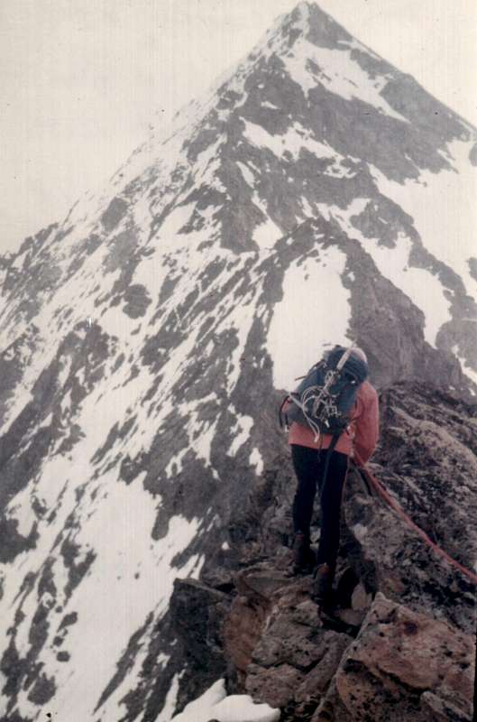 |
D)- Crossing Mount Père Laurent/Emilius: from Regional Pila's Road/
Rayer of TzaT/Reverier Dessous or Lower/Rongachet's small Bridge, between Charvensod-Pollein Municipalities/Rongachet Village/Martsaouchy Desott, du Meitin and Dessus (1h'15/1h'30) Alpages/Plan Croix Old Alp (ruines)/Arpisson's Wallon with Lower and Upper Pastures/Western Face of Mount Père Laurent (2h'30/2h'45)/ Points & Becca of Seneva through N-NW Ridge (passages of II°/II°+ on thread with one of III°-)/Peckoz Pass/Testa Blantsette & Carving/NE Crest of Black Triangle and N Edge of Emilius (3h'30/4h'00; 12h'30/13h'30).
The Wild Watershed amongst Arpisson (in bottom) & Laures Vallons
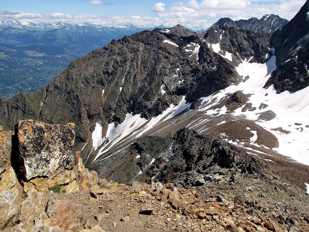 |
Historical FEATURES
This great divide between the Arpisson and Les Laures
of which we have just discussed above, paradoxically, was first climbed in his most difficult part (N-NE Edge, 1906) and later in the simplest (N-NW Ridge of Becca Seneva, 1924), but other traits, the ascent of Mount Père Laurent, Peckoz Pass, Head Blantsette and nearby Carving Blantsette's Pass were visited and frequented "ab immemorabilis" by shepherds and hunters, forming the famous "Passer the Cordagnì" with which the latter they identified and signaled a definite place hunting, always well heeled by Gamekeepers of Baron Beck Peckoz, Walser originally from Valley of Gressoney, who guarded these vallons and that of Grauson-Lussert up to the current Grauson New (Hunting Houses in Mulac-Saint Louis, Greate Chaux, small refuge under the Carrel Hill, now completely destroyed and rebuilt, and still in the Grande Chaux in Grauson Walloon, corresponding to the current New Grauson. Seneva the normal route to (S Crest, after having climbed the O Face, 1897) instead was "up down", by the rope of 30 August, which came to Col Peckoz to get off on both Eastern and Western Glaciers of th'Arpisson with the intent to observe the still virgin on which North Face of Emilius, the next day, make an attempt to uphill. But almost certainly, this part of the ridge, incidentally easy, had already been beaten by Guards Hunting Reserve Peckoz, wherefore to Daniele Devalle with the two Mountain Guides of Valtournanche Bich and Pession is nothing more than the first climbing mountaineering note. There was still a short section of ridge to explore, what Renato Chabod with two companions, G. Riconda and A. Nouchy, had escaped, or between Mount Père Laurent and the onset of North-northwest Ridge rising from them: "... June 15, 1924, on the opposite side of the Combe of Arpisson, reaching the crest of Père Laurent-Becca of Seneva a hundred yards South of the Père Laurent and then continuing along the ridge to the Becca Seneva. remember a pleasant dihedral with crack, excellent gray gneiss and the long descent to Quart Villefranche, through the lakes Laures. ". We went to remove the '"footprint" July 20, 1978 when with my son Christian (5 years!) and Professor Giorgio Fruttaz, starting from Martsaouchy and, this time, to the Valley of Arpisson, we went first to the Père Laurent (2.625m ) and then cross, return, those three small tops (2646m, the highest South Point, even if only slightly), the surprise was that at the top of the first, between an unbearable stench, we found a dozen dead sheep. Exposing us to the big jump to the East, we saw the rest of the flock, smashed on stony ground below. The storm had driven up there and missed the first one, all the others had gone behind. As in the famous painting "of the blind", by Bruegel, if I'm not mistaken. We covered so that little more than a hundred yards that were missing, among broken rocks and covered with dangerous and treacherous grass "Ollina".
 |
 |
 |
 |
 |
Questo grande spartiacque tra l'Arpisson e Les Laures
del quale abbiamo giusto sopra trattato, paradossalmente é stato salito dapprima nella sua parte più difficile (Spigolo N-NE,m 1906) e successivamente in quella più semplice (Cresta N-NW della Becca Seneva, 1924); ma gli altri tratti, ovverossia salita del Mont Père Laurent, Col Peckoz, Testa Blantsette e vicino Intaglio o Colle Blantsette erano stati visitati e frequentati "ab immemorabilis" da pastori e cacciatori, costituendo il famoso "Passer lo Cordagnì" con i quale questi ultimi individuavano e segnalavano un preciso luogo di caccia, sempre ben tallonati dai Guardiacaccia del Barone Beck Peckoz, Walser originario della Valle di Gressoney, che presidiavano questi valloni e quello del Grauson-Lussert fino all'attuale Grauson Nuove (Case di Caccia a Mulac-Saint Louis, Grande Chaux, piccolo rifugio sotto al Colle Carrel, andato distrutto ed oggi completamente ricostruito, ed ancora di Grande Chaux nel Grauson, corrispondente all'attuale Grauson Nuove. La via normale alla Seneva (Cresta S, dopo la salita per la Faccia O, 1897) invece fu "salita in discesa" dalla cordata del 30 Agosto, che giunse al Col Peckoz per quindi discendere sui due Ghiacciai Orientale ed Occidentale di Arpisson con l'intento di osservar l'ancor vergine Parete Nord dell'Emilius sulla quale, il giorno appresso, effettuarne un tentativo di salita. Ma quasi sicuramente, questo tratto di cresta, daltronde facile, era già stato battuto dalle Guardie di Caccia della Riserva Peckoz, per la qual cosa quella di Devalle-Daniele con le due Guide di Valtournanche Bich e Pession altri non é che la prima ascensione alpinistica nota. Rimaneva ancora un breve tratto incognito di cresta da esplorare, quello che Renato Chabod con i due compagni, G. Riconda ed A. Nouchy, aveva evitato, ovvero tra il Mont Père Larent e l'inizio della Cresta Nord-nordovest da loro salita: " ... il 15 Giugno 1924, sull'opposto versante della Comba di Arpisson, raggiungendo la cresta Père Laurent-Becca di Seneva un centinaio di metri più a sud del Père Laurent e poi continuando per cresta fino alla Becca di Seneva. Ricordo un piacevole diedro con fessura, di ottimo gneiss grigiastro, nonché la lunga discesa fino a Quart Villefranche, passando per i laghi di Laures.". Andammo a togliere l'"ingombro" il 20 Luglio 1978 quando con mio figlio Christian (5 anni!) ed il Professor Giorgio Fruttaz, partendo da Martsaouchy e, questa volta, per il Vallone di Arpisson, salimmo dapprima al Père Laurent (2.625 m) per poi attraversare, andata e ritorno, quelle tre puntine (2.646 m, la Punta Sud più elevata, anche se di poco); la sorpresa fu che in vetta al primo, tra un fetore insopportabile, trovammo una decina di pecore morte. Esponendoci sul grande salto ad Est, vedemmo tutto il resto del gregge, sfracellato sulla sottostante pietraia. Il temporale le aveva spinte fin lassù e, saltata la prima, tutte le altre le erano andate dietro. Come nel famoso quadro "del cieco" di Bruegel, se non sbaglio. Così coprimmo quel poco più di un centinaio di metri che mancavano all'appello, tra rocce rotte e ricoperte da pericolosa ed infida erba "ollina".
E) - Traverse Peak Garin/Mount Emilius: from Pila
 |
Pila Resort/ Chamolé Lake & Hill/Arblole Vallon with two Lochs and Refuge (T/E; 2h'15/2h'30)/Garin Pass & Lake (EE; 3h'30/4h'00)/Garin Peak through Southwest on NorthWest and Nord Edge (better; I°; II°+ and III°- on thread, more amusing)/crossing to Mount Valaisan & Pass (A; 7h'00/7h'30)/Emilius Three Red Points/Arbolle Hill/Point of Three Capuchins & Pass/Emilius (A; 10h'00/10h'30) . Return through same route passing Fozen Loch (EE/A; 12h'00/14h'00).
From Gimillan Hamlet: /Arpisson Vallon & Pasture/Plan Bessey Tableland/Franco Nebbia Bivouac/Garin Lake and same two precedent routes (EE/A; same times).
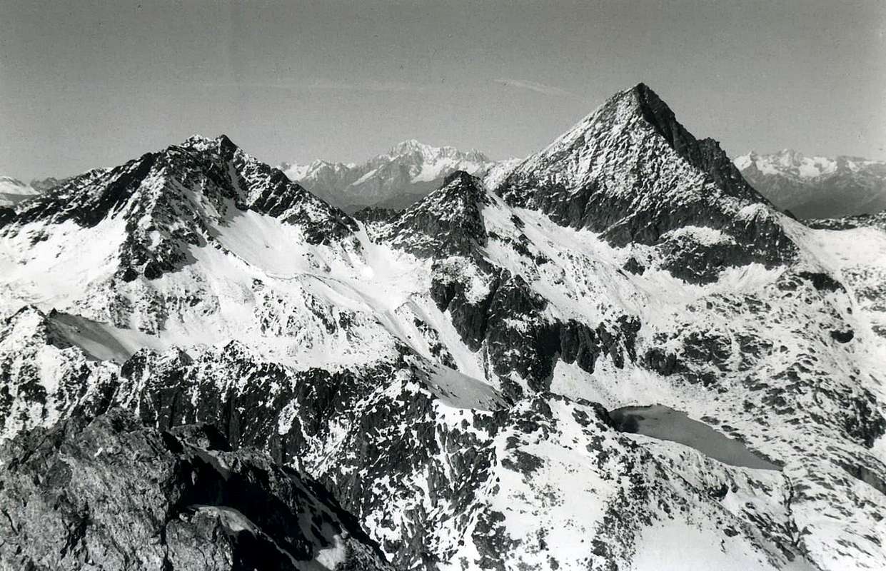 |
Historical FEATURES
After a taste of Agostino Ferrari, going in the opposite direction from the Col d'Arbolle (3.154m), with the Mountain Carrier of Cogne B. Glarey September 14th, 1898 that perform the crossing Emilius Red Points-Peak Garin (the day after will make the crossing of Roises), this oceanic traverser could only be carried out by the "camel" Dr. Anselme "Ansel" Falcoz (Dent Blanche for "Crest of the Four Donkeys", by bike (the Thirties extremely heavy and the "brakes" plunger!) from Aosta, round trip, passing the Great Saint Bernard Hill!!!). In the Month of August 1936 from his home in our part Fernier, quite a bit to the Western of Pila, go to Chamolé Lake, crosses the hill, go to Arbolle, "burn" even the Garin Hill, surpasses the lake, up to the Garin Peak (how many Sometimes he climb?: "An infinity!" he tells me in 1978 telling his adventures with fun and joy, despite a problem with one eye and amputation for a tumor in his leg, "But skied anyway. Except that once I escaped the prosthesis and skiers of Pila were terrified by the sight of come down a ski coming down from above with only half a leg". This was Dr."Ansel", which gave me to keep his story of war, which I still have in a drawer. I would like to return it, but his family does not exist anymore. Or almost. So by Garin falls Mount Valaisan, the next hill or Pas, "dribble" the three Points Red, falls below Arbolle's Pass, round the Point of the "Three Capuchins", which then had no name, comes homonymous pass and still the same name Cresta or South-southwest it "lays" on Emilius. Fernier Then come back to. All in one daily. After the first winter at Point Garin (on Christmas Day of '36, with his brother Pierluigi, called "Piero" and those solitary the Grauson Tower (5/6/7 February '39), and, in the same winter in the middle of World War II, the three Summits of Emilius's Red Points (11/12 March 1939), we find him in 1940, where the Professor of Turin Massimo Mila go up the Central Couloir on the North Emilius: "We ascended so well together regularly and that we refer the time to tie using the rope, that we forgot arriving on the West Ridge and then on top without using it. Or July 5, 1964, when he left the chute on the North Wall of the Summit East of the Red Points with Giorgio Mondini and the dog Kalì (business found me in August of '75, in a small box of rusty meat under a rock.) But the Doctor the "camel" of '36 was not enough and so in the Summer of 1947, the war is now terminated, tries again. They stop the pass of "Three Capuchins" of his companions, he said, "defeatists." We (the undersigned with Marco Cossard aka "Crevassino" and Joseph Lamazzi, said "The Peppino", stimulated the imagination, June 29, 1976 (on the Day of Peter and Paul and of Fires over th'Emilius) can not be outdone. Even so we, who as a "camel" we are second to anyone, we are following in the footsteps of Dr. Falcoz. All in a day, but from Pila, a little closer to that Fernier. Though, from "Purists", also cross the Top of the "Three Capuchins", which was then still unknown Quote IGM 3.283 meters, not bad: start at 7 '00, arrival to the Summit at around 19'00 (granting of various stops for about 2h'00), meeting with the Band Brissogne, led by Giovanni Matteo Zulian, said " Augustine " and inevitable Fireworks show with the fires, in the dark, the light suggestively Emilius. Then, everybody goes ... We remain Guido Allegri Charvensod and I to make the bivouac, "in full nature", ie nothing. Makes even hot and we get stuck between two rocks red (what an idiot, all the rocks are red in Emilius!). Night brings counsel, and so we fall asleep peacefully. Halfway through the same powerful rumble of thunder wakes us up, along with the first drops. Damn, we do not have the lights, not batteries, not even a candle, indeed Guido (who died last year), which is a smoker, has the lighter. Racing doooown the ridge, so it is brightly lit by lightning! It is an apocalyptic scene. Missing only one camera to film these two shapes "spinning", which stand out against the burning sky jumping from boulder to boulder, like a ride of the Valkyries, appearing and disappearing for a moment between a lightning strike and another.
But the next day at 7 '00 are home to go to the pool to work. It must have been a Dream, a little nice and a little ugly!
Who wants to try again, trrrry ...
 |
 |
 |
 |
 |
Dopo un assaggio di Agostino Ferrari, con salita dal Col d'Arbolle (3.154 m), con il Portatore "Cogneinse" B. Glarey, che il 14 Settembre 1898 compiono la traversata Punta Rossa-Punta Garin (il giorno dopo effettueranno quella delle Roises), questa oceanica maratona poteva soltanto essere realizzata da quel "cammello" del Dottor Anselme "Ansel" Falcoz (Dent Blanche per la "Cresta dei Quattro Asini" in bicicletta (quelle Anni Trenta estremamamente pesanti e con i freni "a stantuffo!) da Aosta, andata e ritorno, attraversando il Colle del Gran San Bernardo!!!!!!!). Nel Mese di Agosto del 1936 il nostro parte da casa sua a Fernier, un bel pò ad Occidente di Pila, va al Lago di Chamolé, scavalca il colle, entra ad Arbolle, "brucia" anche il Col Garin, sorpassa il lago omonimo, sale alla Garin (quante volte la ha salita?: "Un infinità!", mi dice nel 1978 raccontandomi le sue avventure, con divertimento ed allegria, nonostante un problema ad un occhio e l'amputazione per un tumore ad una gamba: "Ma sciavo ugualmente. Solo che una volta m'é sfuggita la protesi e gli sciatori di Pila erano terrorizzati dal fatto di vedere venir giù uno sci che scendeva da solo con sopra una mezza gamba!". Questa era il Dottor "Ansel", che mi diede a conservare un suo racconto di guerra, che possiedo ancor oggi in un cassetto. Vorrei restituirlo, ma della sua Famiglia non esiste più nessuno. O quasi. Così dalla Garin scende al Mont Valaisan, al successivo colle o Pas, "dribbla" le tre Punte Rossa, discende al sottostante Colle di Arbole, aggira la Punta dei "Tre Cappuccini", che allora non aveva nome, arriva all'omonimo Passo e per l'ancor omonima Cresta o Sud-sudest si "depone" sull'Emilius. Poi torna a Fernier. Tutto in un giorno. Dopo le prime invernali alla Punta Garin (il giorno di Natale del '36, con il fratello Pierluigi, detto "Piero" e quelle solitarie alla Tour Grauson (5/6/7/ Febbraio '39), nonché, nello stesso inverno in piena II° Guerra Mondiale, alle tre cime della Punta Rossa dell'Emilius (11/12 Marzo del 1939), lo ritroviamo nel 1940, dove con il Professore di Torino Massimo Mila salgono il Canale Centrale sulla Nord dell'Emilius: "Salivamo così bene e regolarmente insieme, che rinviammo il momento di legarci utilizzando la corda, che ce ne dimenticammo arrivando sulla Cresta Ovest e poi in cima senz'usarla. Oppure il 5 di Luglio del 1964, quando fece lo scivolo di sinistra sulla Parete Nord della Sommità Est della Punta Rossa con Giorgio Mondini ed il cane Kalì (biglietto da me ritrovato nell'Agosto del '75, in una piccola scatola arruginita di carne sotto ad un sasso). Ma al Dottore la "cammellata" del '36 non era bastata e così nell'Estate del 1947, a guerra ormai termoinata, ci riprova. Lo fermano al Passo dei "Tre Cappuccini" dei compagni, a suo dire, "disfattisti". Noi (ovvero il sottoscritto con Marco Cossard alias "Crevassino" e Giuseppe Lamazzi, detto "Il Peppino", stimolati nella fantasia, il 29 Giugno del 1976 (nel Giorno di Pietro e Paolo e dei Fuochi sull'Emilius) non possiamo essere da meno. Così anche noi, che in quanto a "cammellaggine" non siamo secondi a nessuno, siamo sulle orme del Dottor Falcoz. Tutto in giornata, ma da Pila, un poco più vicino che da Fernier. Però, da "veri puristi", attraversiamo anche la Punta dei "Tre Cappuccini", che allora era ancora la sconosciuta Quota 3.283 metri I.G.M.; niente male: partenza alle ore 7 '00, arrivo in vetta intorno alle ore 19'00 (concessione di 2h'00 circa per soste varie), incontro con la Banda di Brissogne, capitanata da Giovanni Matteo Zulian, detto "Agostino" ed immancabile spettacolo pirotecnico con i fuochi che, al buio, illuminano suggestivamente l'Emilius. Poi, tutti se ne vanno... Restiamo Guido Allegri di Charvensod ed io a fare il bivacco, "en plein nature", ossia senza gnente. Fa persin caldo e c'incastriamo tra due rocce rosse (che scemo, tutte le rocce dell'Emilius sono rosse!). La Notte porta consiglio e così ci addormentiamo tranquillamente. A metà della stessa, un potente rombo di tuono ci sveglia, insieme alle prime gocce. Porca miseria, non abbiamo le pile, neanche una candela, anzi Guido ( morto l'anno passato), che é un fumatore, ha l'accendino. Giùuuuuh di corsa per la cresta, tanto é illuminata a giorno dai fulmini! Si tratta d'una scena apocalittica. Manca soltanto una telecamera a riprendere queste due sagome "roteanti", che si stagliano contro il cielo infuocato saltando di masso in masso, come in una cavalcata delle Walkirie, apparendo per un attimo e sparendo tra un fulmine e l'altro.
Ma l'indomani alle ore 7 '00 sono a casa per andare in piscina a lavorare. Sarà stato un Sogno, un pò bello ed un pò brutto!
Chi ci vuole riprovare, pppprovi...
*******
F)- South-southwest Buttress of Punta Garin: from Gimillan Village
The South-soutwest Buttress of Peak Garin from Point of Plan Bessey.
*******
small bridge (about 1800 metres at the beginning of Arpisson's Vallon (T; 1h'00) & S-SW Crest of Arpisson's Point (EE/A; 2h'30) to Antesummit of Arpisson's Point/Pila's SW Pass/Points Coupées of Arpisson (SE, Central and NE; A; passages of I°/II°; 4h'30/5h'00) Pila' NE Pass/Arpisson's Tower/Fleurie or Fiorito Point/two Lavà's Tops/Garin Peak through South Crest (AExp.; PD+; passages of II°/II°+, on thread III°-/III°; 7h'30/8h'00). Retourn through E-SE Crest to Chaz-Fleurie Vallon/Grauson Vieux small Village (in ancient exclusively Pastures)/Grauson Vallon/Pila Alp with Waterfall/E'closeur Pastures and small Bridge over Lussert Torrent/ Reventi tiny Chapel/Gimillan Hamlet. (EE/A; passages of I°/II°-; 11h'00/11h'30).
Or return to Pila's Basin, through N Edge & NW Ridge to Garin Loch and Pass/Arbolle's Vallon and Refuge (A; 10h'00/10h'30). From Refuge through Chamolé Pass or Comboé Vallon to Pila Resort (1h'30/2h '00; 12h'00/13h'00).
*******
Historical FEATURES
*******
La storia di questo lungo e frastagliato contrafforte, atto a separare i Valloni di Arpisson ad Occidente da quello del Grauson ad Oriente, non ha nulla da invidiare, in quanto a lunghezza, al Sudovest dell'Emilius e, mentre quello va ad innestarsi sulla Cresta Ovest del medesimo all'altezza del Mont Ròss de Comboé, questo raggiunge la Cresta Sud della Punta Garin, diventando la prosecuzione topografica naturale. Anche qui ne descriveremo lo sviluppo in discesa, ovvero da Settentrione a Sud, se non altro per rispetto ai primi alpinisti che lo percorsero in questo modo fino alla Torre di Arpisson (3.227 m), per poi concludere sul Versante Est della medesima con una alquanto complicata traversata a mezza costa verso l'antichissimo Villaggio di Grauson Vieux (2.273 m). Il 20 Agosto 1897 infatti W.C. Compton, A.V. Valentine Richards con le Guide Svizzere Alois e Siegfried Burgener, dopo la salita alla Garin lungo la Cresta Sudovest, scendono per la Sud andando ad esplorare il contrafforte. Questo, dopo un "Intaglio" (3.285 m), detto della Garin, prosegue frastagliato con leggera direzione a Sudovest, formando tutta una serie di punte alternate ad incisioni ed a tre colli, per raggiungere infine il Col di Pila Sudovest (3.028/30 metri circa) e la successiva e viciniora Punta di Arpisson (3.035 m); da qui la parte terminale si sdoppia inviando una cresta di rocce brunastre e rotte a blocchi in direzione dell'"entrata" del Vallone di Arpisson ad una selletta (2.317 m). Una seconda ramificazione s'indirizza invece a Sudest verso la Tsaplana (2.681 m), sommità tondeggiante proprio sopra il Villaggio di Gimillan, sulla quale é stata posta una bella ed "argentata" Madonna. Ma i due inglesi, come detto sopra, si fermano alla Torre di Arpisson; su questa, formata da 7 torrette, trovano l'ometto in pietra eretto appena una settimana prima, il 13 Agosto 1897, da George Yeld, che, con la Guida di Valtournanche François Pession, l'aveva salita per la Parete Ovest e, nell'ultimo tratto, tramite la corta Cresta Nord. Nel loro percorso, dopo una quota secondaria (3.261 m), aggirarono la sommità della Punta Fiorito o Fleurie (3.261 m) e, probabilmente le due elevazioni successive, oggi chiamate Punte di Lavà (3.218 m, 3.227 m), raggiungendo il Col Fleurie (3.187 m); questo era stato attraversato il primo di Settembre 1894 dal Vallone di Grauson a quello di Arpisson dalla ben più celebre Guida Svizzera Alexander Burgener insieme a F.W. Oliver con C. Hiatt e C. Baker onde salire alla Garin, stessa via, con un approccio a dir poco esotico. Infatti il colle, allora senza nome e così successivamente battezzato dallo Yeld nel 1897 (vedi "Scrambles in the Eastern Graians 1878-1897" ed "Alpine Jounal" XVIII, pag. 245 "RM" C.A.I. 1897, 134; lo stesso, sempre nel 1897, stesse fonti, aveva compiuto la prima traversata del Col di Pila Sudovest da Ovest ad Est con le Guide di Valtournanche François e Sylvain Pession), presenta ad Est un alquanto ripido, stretto e faticoso canale di sfasciumi e, sul lato opposto, un altrettanto vertiginoso pendio di rocce frantumate e poco sicure. Ma siamo nell'Epoca delle Esplorazioni e ... degli Inglesi.
Mancava ancora il percorso tra il Col di Pila Nordest (3.187 m) e la Punta di Arpisson, attraversando le tre Punte Coupées. Dopo una prima invernale a questa ultima con traversata delle tre Punte Coupées di Arpisson (Punta NE 3.213/5 m circa, Punta Centrale 3.120/2 m circa e Punta SW 3.231 m, la più alta) e discesa al brivido notturna e senza luci e senza ramponi dal Colle Nordest con un canale ghiacciato di 1.000 metri fin sopra l'Alpe e Cascata di Pila, effettuata da Osvaldo Cardellina con Giuseppe Lamazzi l'8 Gennaio 1978, sempre nello stesso anno, il 17 Settembre, il medesimo con Camillo Roberto Ferronato risale integralmente l'intero contrafforte assolutamente sul filo di cresta, partendo in giornata da Gimillan ed iniziando dall'imbocco del Vallone di Arpisson, quindi tramite la cresta Sudovest dell'omonima punta. Viene anche effettuata la probabile prima salita delle due Punte di Lavà e della bella Punta Fiorito o Fleurie in circa 7h'30, soste comprese. La stessa salita verrà ripetuta probabilmente nell'Estate del 1981 da Franco Brevini e Compagni, iniziando dal Col di Pila Nordest dal versante Ovest, ovvero di Arpisson, escludendo quindi il tratto dalla Punta di Arpisson al medesimo. La prima invernale é opera da parte di Erik Rosazza e Compagni forse nell'inverno 2011/12.
*******
Questa cresta costituisce la testata dei Valloni delle Laures e del Lussert
e s'allunga sull'asse Ovest/Est tra il Colle des Laures (3.035/6 m) e la Punta di Leppe (3.305/7 m), importante nodo topografico ove la cresta spartiacque, fino a qui divisoria dei predetti valloni, si sdoppia. Un ramo scende a Settentrione verso l'omonimo Colle (3.110 m), prima della Catena delle Roèses o Roises (da Roizà, ovvero Ghiacciaio); una seconda ramificazione volge a Sud-sudest raggiungendo il piccolo Col Vallonet, l'omonima punta e l'importante Colle di Saint Marcel o Coronas, ovvero di Giuseppe Corona che per primo l'attraversò in inverno nel 1875.
Questa lunga cresta non evidenzia particolari rilievi se non il Mont des Laures (3.121 m), subito appresso al colle, e la Punta di Lussert o Quota 3.216 m; un'evidente breccia la separa dalla soprastante Punta Ovest di Leppe (sono tre le piccole elevazioni di questa corpulenta montagna chiamata dai locali Punta del Piccolo Vallone), formando un plateau appena sott'al quale, da pochi anni con lo scioglimento delle nevi, occhieggia un minuscolo laghetto. A Nord di questa una volta s'estendeva il Ghiacciaio di Leppe, ormai ridotto a glacio-nevato, e del quale rimangono ormai misere tracce alla base del Versante Settentrionale della montagna. Cresta per nulla frequentata per anni, incomincia ultimamente a registrare passaggi nel breve tratto tra il Col ed il Mont des Laures, evidenziati da sottile traccia di sentiero, che appare e scompare tra grandi "clapey" brunastri, tra i quali uno s'erge imperioso a guisa di "Grande Cannone". Continuando nel suo sviluppo verso Est la medesima forma due quote secondarie (3066 m, 3.092 m), una depressione (3.079 m), un'altra quota (3.111 m), una seconda depressione (3.094 m), che dovrebbe corrispondere alla quota 3.084 m della Vecchia Carta C.A.I. ed al punto al quale son probabilmente saliti Agostino Ferrari ed il Portatore di Cogne B. Glarey partendo dal Lac Dessous des Laures e compiendo la prima ascensione, anche se parziale, di questa lunga cresta; il 15 Settembre del 1898. Da questo punto la medesima forma ancora un'altra quota (3110 m) e si rialza ulteriormente a due successive Quote (3.189 m, 3.218 m); questa ultima é stata chiamata in "Guida del Monte Emilius", 1978, Punta di Lussert e corrisponde alla Quota 3.221 m della Carta I.G.M. al 25.000. Oltre, ed a Nord, in un plateau-terrazzo nevoso, che va sempre più riducendosi, appena al di sotto del successivo Colletto di Lussert (3.205 metri circa), é sorto un minuscolo laghetto glaciale corrispondente al punto quotato 3.181 m della Carta "Valle di Cogne Carta dei sentieri 10", Edit. "L'Escursionista". Da questo punto la Cresta si rialza più ripida e, lasciando a Sud una ramificazione secondaria formante la Punta di Tsesère (3.108 m), sale alla Vetta Occidentale (3.290/5 metri circa) e, dopo una caratteristica sella arrotondata con detriti od un residuo di nevato, raggiunge la Vetta Centrale (3.305/7 m), la più elevata.
I primi a menzionare questa cresta sono Giovanni Bobba e Luigi Vaccarone che nella loro "Guida delle Alpi Occidentali Vol. II. Parte Seconda Le Valli di Aosta, di Biella, della Sesia e dell'Ossola", Edita dalla Sezione di Torino del Club Alpino Italiano, dove alla pagina 65 la inquadrano tra le varie salite del "b) Pel versante nord-ovest. - ...La cresta nord, nevosa, é praticabile; lo stesso é della cresta ovest formata però di roccie difficili.". Non si sa se questa affermazione corrisponda alla conoscenza di salite avvenute o piuttosto ad una analisi sommaria dal basso, come spesso riscontriamo in B&V; comunque due anni dopo il Ferrari concretizzò il quesito. Così i medesimi in RM C.A.I. 1898, pagine 481 e 489:" Lago Dessous e per il ghiacciaio di Lussert, toccando la depressione tra la Punta 3.084m I.G.M. (vecchia carta) e la Punta di Leppe. Ripidissima ed interessante questa cresta Ovest, la cui salita si svolge per scaglioni di roccia prerutta e vertiginosi (ore 3,50 dal lago Dessous); discesa per la nevosa faccia N-O. ". Il Ferrari confonde il Ghiacciaio di Lussert, ormai estinto e sottostante la Tour Grauson, con la continuazione Occidentale del vicino di Leppe e che, molto probabilmente, si doveva chiamare Ghiacciaio des Laures. Dei tre sono rimaste scarse tracce (ma esiste ancora la tyerminale con il suo imbocco di ghiaccio verdastro) solo di quello di Leppe, ai piedi del Versante Settentrionale dell'omonima Punta.
La cresta é stata integralmente salita, con partenza dal Col des Laures, da Osvaldo Cardellina il 12 Luglio 1988, non trovando alcun segnale o traccia di passaggio, se non nel primo tratto precedente il Mont des Laures; negli ultimi anni questa traccia si é rinforzata con il passaggio più frequente di escursionisti, ma si perde nell'ultima parte, oltre il "Gran Cannone" contro a grandi blocchi prima brunastri e poi rossicci.
Dalla Vetta si offrono due possibilità:
a) - scendere a Nordest, superando la terza e modesta Cima Orientale di poco più bassa, e lungo la cresta, subito sotto ad Ovest con paline di divieto di caccia, arrivare al Colle di Leppe inserendosi nella Catena delle Roéses; questo fecero i primi salitori, che ne compirono la traversata in senso opposto alla cordata Carrel-Lucat-Decaroli del 1875.
Ma l'indomani alle ore 7 '00 sono a casa per andare in piscina a lavorare. Sarà stato un Sogno, un pò bello ed un pò brutto!
Chi ci vuole riprovare, pppprovi...
 |
F)- South-southwest Buttress of Punta Garin: from Gimillan Village
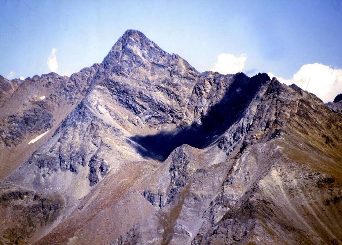 |
small bridge (about 1800 metres at the beginning of Arpisson's Vallon (T; 1h'00) & S-SW Crest of Arpisson's Point (EE/A; 2h'30) to Antesummit of Arpisson's Point/Pila's SW Pass/Points Coupées of Arpisson (SE, Central and NE; A; passages of I°/II°; 4h'30/5h'00) Pila' NE Pass/Arpisson's Tower/Fleurie or Fiorito Point/two Lavà's Tops/Garin Peak through South Crest (AExp.; PD+; passages of II°/II°+, on thread III°-/III°; 7h'30/8h'00). Retourn through E-SE Crest to Chaz-Fleurie Vallon/Grauson Vieux small Village (in ancient exclusively Pastures)/Grauson Vallon/Pila Alp with Waterfall/E'closeur Pastures and small Bridge over Lussert Torrent/ Reventi tiny Chapel/Gimillan Hamlet. (EE/A; passages of I°/II°-; 11h'00/11h'30).
Or return to Pila's Basin, through N Edge & NW Ridge to Garin Loch and Pass/Arbolle's Vallon and Refuge (A; 10h'00/10h'30). From Refuge through Chamolé Pass or Comboé Vallon to Pila Resort (1h'30/2h '00; 12h'00/13h'00).
 |
 |
 |
 |
 |
Historical FEATURES
The history of this long and indented spur, which separates the Vallons of Arpisson in the West than in the East of Grauson, has nothing to envy in terms of length, to the Southwest of Emilius, and while that goes to graft on the West Ridge of the same at the height of Mount Ròss of Comboé, this reaches the ridge south of Punta Garin, becoming the natural continuation topographical. Even here we describe the development of the same downhill, or from north to south, if for no other reason than the first climbers who walked this way to the Tower of Arpisson (3.227m), then finished on the East side of the same with a complicated crossing half coast towards the village, very antique, Grauson Vieux (2.273m). The 20 August 1897 in fact toilet bowl Compton, A.V. Valentine Richards with the Guides Swiss Alois and Siegfried Burgener, after the climb to the Garin along the Southwest Crest, down to the South going to explore the buttress. This, after a "Carving" (3.285m), of said Garin, continues jagged with light in the southwest direction, forming a series of peaks alternate with incisions and three neck to finally reach the Pila South-west Hill (about 3.028/30m) and the next and nearest Point of Arpisson (3.035m), hence the terminal part is doubled by sending a ridge of rocks brownish and broken block in the direction of '"entry" of the Valley of Arpisson at a small saddle (2.317m). A second branch is directed instead towards the Southeast Tsaplana (2.681m), domed Gimillan just above the village, on which has been given a beautiful and "silver" Madonna. But the two Englishmen, as mentioned above, they stop at the Tower of Arpisson and on this, consisting of 7 small towers, are the mound of stone erected just a week before, August 13, 1897, by George Yeld, which, with the help of François Chamois Pession, the wall had climbed for the West and, in the last section, through the short Northern Ridge. In their route, after a secondary elevation (3.261m), skirted the top of Point Fleurie or Fiorito (3.261m) and probably the two successive elevations, now called Points of Lavà (3.218m, 3.227m), reaching the Col Fleurie (3.187m), this was the crossing in September 01th, 1894 from the Vallon of Grauson to that of Arpisson from the more renowned Swiss Mountain Guide Alexander Burgener with FW Oliver C. Hiatt and C. Baker to go to Garin, the same route, with an approach to say the least exotic. In fact the hill, then without a name, and so subsequently baptized by Yeld in 1897 (see "Scrambles in the Eastern Graians 1878-1897" and "Alpine Jounal" XVIII, p. 245 "RM" CAI, 1897, 134; the same, again in 1897, the same sources, he had made the first crossing of the Pila's Southwest Hill from West to East with the Valtournanche's Mountain Guides François and Sylvain Pession), to the East has a very steep, narrow and difficult couloir of debris and, on the opposite side, an equally giddy slope of crushed rocks and unsafe.
But we are in the Age of Exploration and ... of the English. There was still the route between the Northeast and the Pila's Hill (3.187m) Top of Arpisson, through the three Summits of Coupées Arpisson's Points (Point NE about 3.213/5m, Central Summit 3.120/2m around and Top SW 3.231m). After the first winter with this last crossing of the three Points Coupées of Arpisson and descent thrilling night with no lights and bo crampons from the Northeast Pass with a icy gully of 1.000 meters up on the Alp and Waterfall Pila, performed by Osvaldo Cardellina with Joseph Lamazzi January 8th, 1978, in the same year, on September 17, the same with Camillo Roberto Ferronato was full the entire buttress absolutely on the edge of the ridge, starting in a day from Gimillan Hamlet and starting from the entrance of the Arpisson's Walloon, then through the Ridge Southwest of the homonymous point. It is also likely made the first ascent of the two Points of Lavà and the beautiful Point Fleurie also Fiorito in about 7h'30, stops included. The climb itself probably will be repeated in the summer of 1981 by Franco Brevini and Companions, starting from the Pila's Northeast Pass through the West Side, or of Arpisson, thus excluding the stretch from the Top to the same Arpisson. The first winter is the work by Erik Rosazza and Companions, perhaps in the winter 2011/12.
 |
 |
 |
 |
 |
La storia di questo lungo e frastagliato contrafforte, atto a separare i Valloni di Arpisson ad Occidente da quello del Grauson ad Oriente, non ha nulla da invidiare, in quanto a lunghezza, al Sudovest dell'Emilius e, mentre quello va ad innestarsi sulla Cresta Ovest del medesimo all'altezza del Mont Ròss de Comboé, questo raggiunge la Cresta Sud della Punta Garin, diventando la prosecuzione topografica naturale. Anche qui ne descriveremo lo sviluppo in discesa, ovvero da Settentrione a Sud, se non altro per rispetto ai primi alpinisti che lo percorsero in questo modo fino alla Torre di Arpisson (3.227 m), per poi concludere sul Versante Est della medesima con una alquanto complicata traversata a mezza costa verso l'antichissimo Villaggio di Grauson Vieux (2.273 m). Il 20 Agosto 1897 infatti W.C. Compton, A.V. Valentine Richards con le Guide Svizzere Alois e Siegfried Burgener, dopo la salita alla Garin lungo la Cresta Sudovest, scendono per la Sud andando ad esplorare il contrafforte. Questo, dopo un "Intaglio" (3.285 m), detto della Garin, prosegue frastagliato con leggera direzione a Sudovest, formando tutta una serie di punte alternate ad incisioni ed a tre colli, per raggiungere infine il Col di Pila Sudovest (3.028/30 metri circa) e la successiva e viciniora Punta di Arpisson (3.035 m); da qui la parte terminale si sdoppia inviando una cresta di rocce brunastre e rotte a blocchi in direzione dell'"entrata" del Vallone di Arpisson ad una selletta (2.317 m). Una seconda ramificazione s'indirizza invece a Sudest verso la Tsaplana (2.681 m), sommità tondeggiante proprio sopra il Villaggio di Gimillan, sulla quale é stata posta una bella ed "argentata" Madonna. Ma i due inglesi, come detto sopra, si fermano alla Torre di Arpisson; su questa, formata da 7 torrette, trovano l'ometto in pietra eretto appena una settimana prima, il 13 Agosto 1897, da George Yeld, che, con la Guida di Valtournanche François Pession, l'aveva salita per la Parete Ovest e, nell'ultimo tratto, tramite la corta Cresta Nord. Nel loro percorso, dopo una quota secondaria (3.261 m), aggirarono la sommità della Punta Fiorito o Fleurie (3.261 m) e, probabilmente le due elevazioni successive, oggi chiamate Punte di Lavà (3.218 m, 3.227 m), raggiungendo il Col Fleurie (3.187 m); questo era stato attraversato il primo di Settembre 1894 dal Vallone di Grauson a quello di Arpisson dalla ben più celebre Guida Svizzera Alexander Burgener insieme a F.W. Oliver con C. Hiatt e C. Baker onde salire alla Garin, stessa via, con un approccio a dir poco esotico. Infatti il colle, allora senza nome e così successivamente battezzato dallo Yeld nel 1897 (vedi "Scrambles in the Eastern Graians 1878-1897" ed "Alpine Jounal" XVIII, pag. 245 "RM" C.A.I. 1897, 134; lo stesso, sempre nel 1897, stesse fonti, aveva compiuto la prima traversata del Col di Pila Sudovest da Ovest ad Est con le Guide di Valtournanche François e Sylvain Pession), presenta ad Est un alquanto ripido, stretto e faticoso canale di sfasciumi e, sul lato opposto, un altrettanto vertiginoso pendio di rocce frantumate e poco sicure. Ma siamo nell'Epoca delle Esplorazioni e ... degli Inglesi.
Mancava ancora il percorso tra il Col di Pila Nordest (3.187 m) e la Punta di Arpisson, attraversando le tre Punte Coupées. Dopo una prima invernale a questa ultima con traversata delle tre Punte Coupées di Arpisson (Punta NE 3.213/5 m circa, Punta Centrale 3.120/2 m circa e Punta SW 3.231 m, la più alta) e discesa al brivido notturna e senza luci e senza ramponi dal Colle Nordest con un canale ghiacciato di 1.000 metri fin sopra l'Alpe e Cascata di Pila, effettuata da Osvaldo Cardellina con Giuseppe Lamazzi l'8 Gennaio 1978, sempre nello stesso anno, il 17 Settembre, il medesimo con Camillo Roberto Ferronato risale integralmente l'intero contrafforte assolutamente sul filo di cresta, partendo in giornata da Gimillan ed iniziando dall'imbocco del Vallone di Arpisson, quindi tramite la cresta Sudovest dell'omonima punta. Viene anche effettuata la probabile prima salita delle due Punte di Lavà e della bella Punta Fiorito o Fleurie in circa 7h'30, soste comprese. La stessa salita verrà ripetuta probabilmente nell'Estate del 1981 da Franco Brevini e Compagni, iniziando dal Col di Pila Nordest dal versante Ovest, ovvero di Arpisson, escludendo quindi il tratto dalla Punta di Arpisson al medesimo. La prima invernale é opera da parte di Erik Rosazza e Compagni forse nell'inverno 2011/12.
 |
 |
 |
 |
 |
G)- Crossing Laures's Pass/Hill of Saint Marcel or Coronas: from Gimillan Hamlet
Gimillan/Reventi Ruins & Chapel//Ecloseur small Bridge/Pila Alp with Waterfall/Grauson Vieux & New Pastures/Corona Lake and W-W Slope of Hill (E; 3h'00/3h'30)/Mount Vallonet & Little Pass/S-SE Crest of Leppe's Point through Lussert's-Leppe's Points & Vallonet's Pass & Mount (EE; 5h'00/6h'00)/Lussert's Carving Point/Mount of Laures & Pass (A; 9h'00/10h'00). From pass two possibilities:
1) - descent before to South at the Lussert Tall Lake and, after, to East to Middle & Lower Lakes/Grauson Nuove & Vieux/Pila Alp/Ecloseur to Gimillan Village (E; 11h'30/12h'00).
2) - descent to Northern in Laures Vallon/Dessus & Long Lakes/Ménabreaz Hut near the Dessous Loch (EE; 2h'15/2h'30). From Refuge descent to Tramouail (private but open shelter), Vieille, L'Arp, Gremonanche Alpages to Grand Brissogne Village (E; 2h'00/2h'15; 11h'00/11h'30).
Leppe's Point Northern Face, from Ilario Antonio Garzotto Point.
*******
Historical FEATURES
This crest is the head of the Vallons of Laures and Lussert and stretches on the West/East between Colle des Laures (3.035/6m) and the Leppe Summit (3.305/7m), topographic important node where the dividing ridge, up to here dividing the aforesaid walloons, splits into two . A branch falls to the North towards the hill of the same name (3.110m), before the Mountain Chain of Roèses or Roises (from Roizà, or Glacier), a second ramification turns to the South-southeast, reaching the small Vallonet Pass, the homonymous peak and the important Saint Marcel or Coronas Hill, or of Joseph Corona who first crossed in winter in 1875.
This long ridge shows no particular reliefs if not the Mount of Laures (3.121m), just after the hill, and the Lussert Point or Quote 3.216 meters; clear gap separates it from the overlying Western Point of Leppe (there are three small elevations of this corpulent mountain, even called from the inhabitants Point of the Little Vallon), forming a plateau just below that, a few years ago with the melting snow, glimpsing a tiny pond. To the North of this once stretched the Glacier Leppe, now reduced to a glacial snowfields, which are now miserable traces at the base of the Northern Slope of the mountain. Ridge for nothing frequented for years, recently began to record steps in the short stretch between Hill and the Mount of Laures, highlighted by a thin trace of the path that appears and disappears between large brownish boulders, including one stands imperious like a cannon. Continuing in its development to the East the same forms two secondary measures (3.066m, 3.092m) a depression (3.079m) another share (3.111m), a second depression (3.094m), which should correspond to the portion of the 3.084 meters Old Paper C.A.I. and the point at which they are likely rose Agostino Ferrari and the Mountain Carrier of Cogne B. Glarey starting from the Lac des Dessous Laures and making the first ascent, even partial, of this long ridge; on September 15th, 1898. From this point the same form yet another dimension (3.110m) and it is raised further in two successive Quotas (3.189m, 3.218m), the latter has been called in "Guide of Mount Emilius", 1978, Point of Lussert and altitude 3.221 meters corresponds to the Charter I.G.M, at 25.000. In addition to the North and in a plateau-snowy terrace, which is more and more reduced, just below the Collar next Lussert (3.205m), will rise a tiny glacial pond that corresponds to the spot elevation 3.181 meters of the Charter "Valley of Cogne paper trail 10", Edit. "L'Escursionista". From this point on the ridge rises again steeper and, leaving a South secondary branching that forms the Point of Tsesère (3.108m) rises to the Western Summit (3.290/5m) and, after a characteristic rounded saddle with debris or residue of a snowfield, reaches the Central Peak (3.305/7m), the highest.
The first to mention this ridge are Giovanni Luigi Bobba and Vaccarone that in their "Guide to the Western Alps Vol II. Second Part The Valleys of Aosta, Biella, the Sesia and the Ossola", Edit. from Turin Section of the Alpine Club Italian, on page 65 where the frame between the different slopes of the "b) Through the north-west. - ... The north ridge, snow, is feasible, and the same is the west ridge of rocks formed, however, difficult.". It is not known whether this statement corresponds to the knowledge of ascents occurred or rather to a summary analysis from the bottom, as we often find in B&V; however, two years after the Ferrari materialize the question. So in the same RM C.A.I. , 1898, pages 481 and 489: "Dessous Lake and Glacier Lussert, touching the depression between Punta IGM 3.084 (old paper) and the tip Leppe. Steep and interesting this western ridge, whose ascent is for brackets preerupts rock and dizzying (3'50 hours from the lake Dessous) down to the snowy face N-O. ". The Ferrari confuses the Glacier Lussert, now extinct and below the Grauson ower, with the continuation of the Western neighbor Leppe and that, most likely, you had to call Glacier of Laures. Of the three were scant traces (but there is still the tyerminale with his mouth greenish ice) only to Leppe, at the Northern foot of the homonymous Punta.
The crest has been entirely uphill, departing from the Col des Laures, by Osvaldo Cardellina July 12th, 1988, finding no sign or trace of passage, if not in the first section prior to the Mount of Laures and in recent years it has reinforced this track more frequent with the passage of hikers, but you lose the last part, as well as the "Great Cannon" against large blocks first and then brownish reddish.
From the summit you have two possibilities:
a) - go to the Northeast, surpassing the third and modest Top Eastern slightly lower, and along the ridge, just below the West with poles of the hunting ban, get to Leppe Hill fitting into the Mountain Chain of Roéses and this did the first climbers, who accomplished the crossing in the opposite direction to the rope Carrel-Lucat-Decaroli, 1875.
b) - go down the easy ridge South-southeast, or Normal Route, the Collar Vallonet (3.062m , to cross the eponymous Mount (3.101m) and without any problem along the crest reaching the Saint Marcel or Coronas Hill (2.913m , large amounts of bluish soapstone nearby and small votive chapel inserted into a rock).
If departure is occurred from the Walloon of the Grauson by the way of Lake Corona (2.702 m) or along one of the three Lakes and Col des Laures through paths n° 8C before and 8A/102 from the junction 2.298 meters , after Grauson Vieux, returning to Gimillan Hamlet with paths n° 8B/102 and then n° 8, but if it has reached the Col des Laures from Ménabreaz Shelter, you must descend into the Vallon of the Fenetre into Valley of Saint Marcel with nthe path n° 4/102 to the junction 2.601 meters and then only with n° 4 for Great Chaux and until the carriage at the Pic Nic Area of Les Druges (1.600 meters. Having to return to Laures instead, use the solution
Gimillan/Reventi Ruins & Chapel//Ecloseur small Bridge/Pila Alp with Waterfall/Grauson Vieux & New Pastures/Corona Lake and W-W Slope of Hill (E; 3h'00/3h'30)/Mount Vallonet & Little Pass/S-SE Crest of Leppe's Point through Lussert's-Leppe's Points & Vallonet's Pass & Mount (EE; 5h'00/6h'00)/Lussert's Carving Point/Mount of Laures & Pass (A; 9h'00/10h'00). From pass two possibilities:
1) - descent before to South at the Lussert Tall Lake and, after, to East to Middle & Lower Lakes/Grauson Nuove & Vieux/Pila Alp/Ecloseur to Gimillan Village (E; 11h'30/12h'00).
2) - descent to Northern in Laures Vallon/Dessus & Long Lakes/Ménabreaz Hut near the Dessous Loch (EE; 2h'15/2h'30). From Refuge descent to Tramouail (private but open shelter), Vieille, L'Arp, Gremonanche Alpages to Grand Brissogne Village (E; 2h'00/2h'15; 11h'00/11h'30).
 |
Historical FEATURES
This crest is the head of the Vallons of Laures and Lussert and stretches on the West/East between Colle des Laures (3.035/6m) and the Leppe Summit (3.305/7m), topographic important node where the dividing ridge, up to here dividing the aforesaid walloons, splits into two . A branch falls to the North towards the hill of the same name (3.110m), before the Mountain Chain of Roèses or Roises (from Roizà, or Glacier), a second ramification turns to the South-southeast, reaching the small Vallonet Pass, the homonymous peak and the important Saint Marcel or Coronas Hill, or of Joseph Corona who first crossed in winter in 1875.
The first to mention this ridge are Giovanni Luigi Bobba and Vaccarone that in their "Guide to the Western Alps Vol II. Second Part The Valleys of Aosta, Biella, the Sesia and the Ossola", Edit. from Turin Section of the Alpine Club Italian, on page 65 where the frame between the different slopes of the "b) Through the north-west. - ... The north ridge, snow, is feasible, and the same is the west ridge of rocks formed, however, difficult.". It is not known whether this statement corresponds to the knowledge of ascents occurred or rather to a summary analysis from the bottom, as we often find in B&V; however, two years after the Ferrari materialize the question. So in the same RM C.A.I. , 1898, pages 481 and 489: "Dessous Lake and Glacier Lussert, touching the depression between Punta IGM 3.084 (old paper) and the tip Leppe. Steep and interesting this western ridge, whose ascent is for brackets preerupts rock and dizzying (3'50 hours from the lake Dessous) down to the snowy face N-O. ". The Ferrari confuses the Glacier Lussert, now extinct and below the Grauson ower, with the continuation of the Western neighbor Leppe and that, most likely, you had to call Glacier of Laures. Of the three were scant traces (but there is still the tyerminale with his mouth greenish ice) only to Leppe, at the Northern foot of the homonymous Punta.
The crest has been entirely uphill, departing from the Col des Laures, by Osvaldo Cardellina July 12th, 1988, finding no sign or trace of passage, if not in the first section prior to the Mount of Laures and in recent years it has reinforced this track more frequent with the passage of hikers, but you lose the last part, as well as the "Great Cannon" against large blocks first and then brownish reddish.
From the summit you have two possibilities:
a) - go to the Northeast, surpassing the third and modest Top Eastern slightly lower, and along the ridge, just below the West with poles of the hunting ban, get to Leppe Hill fitting into the Mountain Chain of Roéses and this did the first climbers, who accomplished the crossing in the opposite direction to the rope Carrel-Lucat-Decaroli, 1875.
b) - go down the easy ridge South-southeast, or Normal Route, the Collar Vallonet (3.062m , to cross the eponymous Mount (3.101m) and without any problem along the crest reaching the Saint Marcel or Coronas Hill (2.913m , large amounts of bluish soapstone nearby and small votive chapel inserted into a rock).
If departure is occurred from the Walloon of the Grauson by the way of Lake Corona (2.702 m) or along one of the three Lakes and Col des Laures through paths n° 8C before and 8A/102 from the junction 2.298 meters , after Grauson Vieux, returning to Gimillan Hamlet with paths n° 8B/102 and then n° 8, but if it has reached the Col des Laures from Ménabreaz Shelter, you must descend into the Vallon of the Fenetre into Valley of Saint Marcel with nthe path n° 4/102 to the junction 2.601 meters and then only with n° 4 for Great Chaux and until the carriage at the Pic Nic Area of Les Druges (1.600 meters. Having to return to Laures instead, use the solution
a) - with descent from Leppe's Hill first on a long moraine and then with the path n° 3 to Lac Long (2.630m), whence briefly at the Refuge (in each of the three cases to calculate from 10h'00 to 12h'00) for the full tour, although there is the possibility to vary the route with numerous alternatives "lighter").
 |
 |
 |
 |
 |
Questa cresta costituisce la testata dei Valloni delle Laures e del Lussert
e s'allunga sull'asse Ovest/Est tra il Colle des Laures (3.035/6 m) e la Punta di Leppe (3.305/7 m), importante nodo topografico ove la cresta spartiacque, fino a qui divisoria dei predetti valloni, si sdoppia. Un ramo scende a Settentrione verso l'omonimo Colle (3.110 m), prima della Catena delle Roèses o Roises (da Roizà, ovvero Ghiacciaio); una seconda ramificazione volge a Sud-sudest raggiungendo il piccolo Col Vallonet, l'omonima punta e l'importante Colle di Saint Marcel o Coronas, ovvero di Giuseppe Corona che per primo l'attraversò in inverno nel 1875.
Questa lunga cresta non evidenzia particolari rilievi se non il Mont des Laures (3.121 m), subito appresso al colle, e la Punta di Lussert o Quota 3.216 m; un'evidente breccia la separa dalla soprastante Punta Ovest di Leppe (sono tre le piccole elevazioni di questa corpulenta montagna chiamata dai locali Punta del Piccolo Vallone), formando un plateau appena sott'al quale, da pochi anni con lo scioglimento delle nevi, occhieggia un minuscolo laghetto. A Nord di questa una volta s'estendeva il Ghiacciaio di Leppe, ormai ridotto a glacio-nevato, e del quale rimangono ormai misere tracce alla base del Versante Settentrionale della montagna. Cresta per nulla frequentata per anni, incomincia ultimamente a registrare passaggi nel breve tratto tra il Col ed il Mont des Laures, evidenziati da sottile traccia di sentiero, che appare e scompare tra grandi "clapey" brunastri, tra i quali uno s'erge imperioso a guisa di "Grande Cannone". Continuando nel suo sviluppo verso Est la medesima forma due quote secondarie (3066 m, 3.092 m), una depressione (3.079 m), un'altra quota (3.111 m), una seconda depressione (3.094 m), che dovrebbe corrispondere alla quota 3.084 m della Vecchia Carta C.A.I. ed al punto al quale son probabilmente saliti Agostino Ferrari ed il Portatore di Cogne B. Glarey partendo dal Lac Dessous des Laures e compiendo la prima ascensione, anche se parziale, di questa lunga cresta; il 15 Settembre del 1898. Da questo punto la medesima forma ancora un'altra quota (3110 m) e si rialza ulteriormente a due successive Quote (3.189 m, 3.218 m); questa ultima é stata chiamata in "Guida del Monte Emilius", 1978, Punta di Lussert e corrisponde alla Quota 3.221 m della Carta I.G.M. al 25.000. Oltre, ed a Nord, in un plateau-terrazzo nevoso, che va sempre più riducendosi, appena al di sotto del successivo Colletto di Lussert (3.205 metri circa), é sorto un minuscolo laghetto glaciale corrispondente al punto quotato 3.181 m della Carta "Valle di Cogne Carta dei sentieri 10", Edit. "L'Escursionista". Da questo punto la Cresta si rialza più ripida e, lasciando a Sud una ramificazione secondaria formante la Punta di Tsesère (3.108 m), sale alla Vetta Occidentale (3.290/5 metri circa) e, dopo una caratteristica sella arrotondata con detriti od un residuo di nevato, raggiunge la Vetta Centrale (3.305/7 m), la più elevata.
I primi a menzionare questa cresta sono Giovanni Bobba e Luigi Vaccarone che nella loro "Guida delle Alpi Occidentali Vol. II. Parte Seconda Le Valli di Aosta, di Biella, della Sesia e dell'Ossola", Edita dalla Sezione di Torino del Club Alpino Italiano, dove alla pagina 65 la inquadrano tra le varie salite del "b) Pel versante nord-ovest. - ...La cresta nord, nevosa, é praticabile; lo stesso é della cresta ovest formata però di roccie difficili.". Non si sa se questa affermazione corrisponda alla conoscenza di salite avvenute o piuttosto ad una analisi sommaria dal basso, come spesso riscontriamo in B&V; comunque due anni dopo il Ferrari concretizzò il quesito. Così i medesimi in RM C.A.I. 1898, pagine 481 e 489:" Lago Dessous e per il ghiacciaio di Lussert, toccando la depressione tra la Punta 3.084m I.G.M. (vecchia carta) e la Punta di Leppe. Ripidissima ed interessante questa cresta Ovest, la cui salita si svolge per scaglioni di roccia prerutta e vertiginosi (ore 3,50 dal lago Dessous); discesa per la nevosa faccia N-O. ". Il Ferrari confonde il Ghiacciaio di Lussert, ormai estinto e sottostante la Tour Grauson, con la continuazione Occidentale del vicino di Leppe e che, molto probabilmente, si doveva chiamare Ghiacciaio des Laures. Dei tre sono rimaste scarse tracce (ma esiste ancora la tyerminale con il suo imbocco di ghiaccio verdastro) solo di quello di Leppe, ai piedi del Versante Settentrionale dell'omonima Punta.
La cresta é stata integralmente salita, con partenza dal Col des Laures, da Osvaldo Cardellina il 12 Luglio 1988, non trovando alcun segnale o traccia di passaggio, se non nel primo tratto precedente il Mont des Laures; negli ultimi anni questa traccia si é rinforzata con il passaggio più frequente di escursionisti, ma si perde nell'ultima parte, oltre il "Gran Cannone" contro a grandi blocchi prima brunastri e poi rossicci.
Dalla Vetta si offrono due possibilità:
a) - scendere a Nordest, superando la terza e modesta Cima Orientale di poco più bassa, e lungo la cresta, subito sotto ad Ovest con paline di divieto di caccia, arrivare al Colle di Leppe inserendosi nella Catena delle Roéses; questo fecero i primi salitori, che ne compirono la traversata in senso opposto alla cordata Carrel-Lucat-Decaroli del 1875.
b) - scendere lungo la facile Cresta Sud-sudest, o Via Normale, al Colletto Vallonet (3.062 m), scavalvare l'omonimo Mont (3.101 m) e senza alcun problema percorrere la cresta spartiacque arrivando al Colle di Saint Marcel o Coronas (2.913 m; grandi quantità di bluastra pietra ollare nelle vicinanze e piccola cappella votiva inserita in una roccia).
Se la partenza é avvenuta dal Vallone del Grauson per la via del Lago Corona (2.702 m) o lungo quella dei tre Laghi e Col des Laures tramite sentieri n° 8C prima ed 8A/102 dal bivio 2.298 metri, dopo Grauson Vieux, rientrare a Gimillan con i sentieri n° 8B/102 e poi n° 8; se invece si é giunti al Col des Laures dal Rifugio Ménabreaz, si deve scendere nel Vallone di Fenetre nella Valle di Saint Marcel con il sentiero n° 4/102 fino al bivio 2.601 metri ed infine solo con n° 4 per Grande Chaux e fino alla carrozzabile presso l'Area Pic Nic di Les Druges (1.600 metri circa. Dovendo invece ritornare alle Laures, utilizzare la soluzione
Se la partenza é avvenuta dal Vallone del Grauson per la via del Lago Corona (2.702 m) o lungo quella dei tre Laghi e Col des Laures tramite sentieri n° 8C prima ed 8A/102 dal bivio 2.298 metri, dopo Grauson Vieux, rientrare a Gimillan con i sentieri n° 8B/102 e poi n° 8; se invece si é giunti al Col des Laures dal Rifugio Ménabreaz, si deve scendere nel Vallone di Fenetre nella Valle di Saint Marcel con il sentiero n° 4/102 fino al bivio 2.601 metri ed infine solo con n° 4 per Grande Chaux e fino alla carrozzabile presso l'Area Pic Nic di Les Druges (1.600 metri circa. Dovendo invece ritornare alle Laures, utilizzare la soluzione
a) - con discesa dal Colle di Leppe dapprima su d'una lunga morena e poi con il sentiero n° 3 verso il Lac Long (2.630 m), donde brevemente al Rifugio (in ognuno dei tre casi calcolare dalle 10h'00 alle 12h'00) per il giro completo, pur esistendo la possibilità di variare il percorso con numerose alternative più "leggere").
*******
H)- Traverse Salé's Becca/Leppe's Hill: from Grand Brissogne Municipality or from Saint Marcel (Old Route of the First Ascent)
Mountain Chain of ROISES; from left: Ilario Antonio Garzotto Point, Grande Roise, Central or Junod Points, Unnamed Peak, Little Roise, Salé's Pass, Becca & Tower. To right Mount Emilius.
*******
Grand Brissogne place/Gremonache Alp at the beginnigof The Laures Vallon/L'Arp (= Alp)/La Vieille Pasture/Le Tramouail last and highest pasture/Black Fountains/Dessous Lakes of Laures & Shelter Ernesto Ménabreaz (E; 3h'00/3h'30); from Refuge W Slope of Salé(ì) Pass & S Crest of Becca; from Salì's Becca return to Pass/N-NW Slope of Antesummit Northern of Little Roise/"Pas du Baton"/N Crest of Little e crossing to a Unnamed Point-Centra Roise or Junod Points (North & South)/N Crest of Grande Roise/descent South Ridge to a small carving/N Ridge of Point Ilario Antonio Garzotto with descent through S Crest-Slope to Leppe Hill. From the hill two possibilities:
1) - to Laures Vallon through remaind of Leppe's Glacier an moraine as far as the fork with paths to Laures & Arbolle Hills/Long Lake/Dessous Lake and same route.
2) - to Saint Marcel Vallon through path on Little Walloon to Grande Chaux Alp & Baron's Beck Peckoz Gamepeeker House/Layet Alp with mini Loch/E'monin Superior & Lower Pastures/Plan Rué Pasture/Mulac-Saint Louis with the first Baron's Beck Peckoz Gamekeeper House/Praborna Alp & Manganese Mines/Etéley Alp/Servette iron & Coppermines/Vargney & Pouria Alpages/to High Les Druges Village, nearby and after the area picnic (1.567m); E; 3h'00 from the hill).
From Salé Pass/Little-Central (Junod Points)-Great Roises/Punta Ilario Antonio Garzotto/Leppe's Hill (10h'00).
* NOTE: This descent is mandatory for those who have used this departure from the Valley of Saint Marcel, rising to Salé Hill, also called "of the Great Roise", through the last part of this descent for the Alp of Rualla (2.265m) and then, after a long diagonal North-northwest towards Vauvire Alp and after into the truly wild Arpisson (not to be confused with those above the Municipality of Pollein and the Village of Gimillan in Cogne Valley);/Bonplan Tall Pasture 2.374m), the last/moraine & remains of Little Roise Glacier/E Slope Salé Hill (EE/A; includes research capabilities of the route; 4h'00/4h'30).
* * An ancient path, now disused and of which few traces remain now, rising from the valley floor to the west of the Torrent of Saint Marcel, starting with two branches from the Villages of Grand-Fauve and Vurvian (726m, 703m), rose along the forest towards Alp of E'chedzen addressing to that of Arpisson (1.830m), at the entrance of the valley of, to finally meet the paths from Choulet and the Alps Rualla and Vauvire, near a small promontory with cross, before entering the valley. This trail, which ran through three small streams below a steep rocky ridge, reached the Alp of Salé (2.209m) and this is the last of Bonplan (2.374m), at the beginning of the moraine below the Little Roise Glacier. Today, perhaps it is not even more popular and departures are all from the dirt road "farm", just before a fork to the Alpage of Vauvire, taking the right path to that of Choulet (1.822m). In any case, to be identified as EE/A.
Arriving on Salé's Hill with in foreground from left or South: "Three Capuchins" Pass, S-SE Crest, SE Face, E Crest & Wall, N-NE Edge and Black Triangle of Mount Emilius; Carving & Testa Blansette, Peckoz Pass. In background Becca of Nona.
*******
* NOTA: Questa discesa è d'obbligo per coloro che avessero usato la partenza dalla Valle di Saint Marcel onde risalire al Col di Salé, detto anche "della Grande Roise", attraverso l'ultima parte di questa discesa per l'Alpe di Rualla (2.265m) e quindi, dopo una lungo diagonale Nord-nord-ovest, passando per l'lpe di Vauvire, in direzione del veramente selvaggio Vallone di Arpisson (da non confondersi con quelli sopra il Comune di Pollein ed oltre il villaggio di Gimillan nella Val di Cogne);/Alpe di Bonplan 2.374 m), ultimo e più elevato pascolo/morena e resti ormai miseri del Ghiacciaio della Petite Roise/Versante Orientale del Col di Salé (EE/A; richiede capacità di ricerca nel percorso; 4h '00/4h '30).
* * Un'antico sentiero, ormai in disuso e del quale rimangono ormai scarse tracce, saliva dal fondovalle ad Ovest del Torrente di Saint Marcel; partendo con due ramificazioni dai Villaggi di Grand-Fauve e Vurvian (726 m; 703m), si innalzava lungo la foresta verso l'Alpe di E'chedzen indirizzandosi a quella di Arpisson (1.830 m), all'ingresso dell'omonimo vallone, per infine riunirsi ai sentieri provenienti da Choulet e dalle Alpi di Rualla e Vauvire, nei pressi di un piccolo promontorio con croce, prima di inserirsi nel vallone. Questo sentiero, attraversante tre piccoli torrenti al di sotto d'un erto costone roccioso, raggiungeva l'Alpe di Salé (2.209 m) e da questa l'ultima di Bonplan (2.374 m), all'inizio della morena sottostante il Ghiacciaio della Petite Roise. Oggigiorno, forse non é neppure più frequentato e le partenze avvengon tutte dalla strada sterrata "poderale", appena prima d'un bivio per l'Alpe di Vauvire, prendendo il sentiero di destra per quella di Choulet (1.822 m). In ogni caso da identificarsi come per EE/A.
ROISES or ROE'SES also ROIZA'; from left: Grande Roise, Central or Junod Points, Unnamed Peak, Little Roise, to Salé's Pass.
*******
Historical FEATURES
This wild Atlas Mountains called the Roèses or, more simply, the Great Roise, or by Roizà glacier, as evidenced by the large lava moraine at the base of its three sides, is known locally as Head or Tita Plana, due to its flat, almost straight Summit (3.356/7m) in the form of large shovel, especially when viewed from Northwest. Its history is "younger" than that of the surrounding Monte Emilius (1823), Becca di Nona (1832, but this is only the first ascent note, since it is easily seen that the inconsistency to highlight the postponement of the rise of Emilius), of Point Garin (1856), understandable for its tricky conformation, as well as for the length of the approaches. Formerly known also very ancient name of Becca of Leppy or the other of Mount of Laures, but these generally showed the whole chain the first, while the second was increasingly focused on its "front door", ie the Becca of Salé (ì), for the residents of Grand Brissogne or climbed, along with those of Saint Marcel, Becca di Nona, to contrast it to the Becca di Nona of Aosta, just two steps further. But even in the Aosta Valley, and the with great manner, there are the "parochialism"!
*******
His mountaineering history begins July 17th, 1875, when the very famous Mountain Guide Valtournanche's Jean Antoine Carrel, along with Albis Lucat and Ange Decaroli depart at 1 o'clock at night from Saint Marcel and along the Fulda Valley arriving at the bridge in dul Torrent 2h '00 and in as many Alp of Salé through the wild, and even then, tough Arpisson's Vallon; another hour to reach the Alpe Bonplan and another unnamed mountain pastures at the foot of the ancient glacier moraines the Petite Roise. From this further in 2h and a total of 7 reached the big saddle between it and the Mount of Laures also called Becca of Salé, who thought to call the Hill of Brissogne or the Great Roise. So in the "Guide de la Vallee d'Aoste" Bich-Gorret, 1876 Edit. Casanova Turin, p. 237, but with already anticipated news from "L'Alpinista" C.A.I., 1875, page 150; to write down also from the Frenchification, not only the names but also of surnames, with Mr. Decaroli that becomes Décaroli: "... The Great Roise, left, is more difficult, you need a good guide to use the rope to the top They went first to the cottage Lores The next day they made the ascent.. Emilius and went to the Cogne Col Garin. ". They have to spend another 23 years for the Great Roise is re-examined: is the celebrated Agostino Ferrari, that of the "Statistics of the First Climbs", 1908 together Mountain Carrier Glarey of Cogne, that after the previous day made the first traverse Emilius's Red Points-Garin Peak rising from Pass of Valaisan, depart from Lake Dessous or Lower to make the crossing in the opposite direction, September 15th, 1898. First reach the Leppe's Point (see crossing G), climbing the West Ridge and down to the "N-O snowy Face", dating from the Hill of Leppe (3.105m) to the current Point Garzotto (3.273/4m), who was unnamed, crossing under West of a about 30 meters under, through a ledge, and then without reaching the summit, climbing over the rounded Top 3.249m will bring me on the actual crest of the Great South Roise. Finally perform the crossing until the Becca of Salé, avoiding the Central Summit or Central Roise, currently Junod Points (about 3298m the small Northern Tower, 3.300m the Southern) via an obvious ledge 20/5 meters below, more to the west, moving from Petite Roise and from the Hill of the Great Roise, then by this fall to Laures. The following year, on June 16th, the same Ferrari in the company of Ettore Quirico and Mountain Guide Grégoire Comé rise again, aim photo, the Hill of the Great Roise and I climb the Little (3.273, 3.279m I.G.M.) and on this occasion they descend to the Valley of Arpisson, lateral and secondary to that of Saint Marcel. Also in "Statistics 1908" the Ferrari creates a bit of confusion is attributing to the first ascent of the Hill of the Great Roise that the Summit of the Petite, forgetting that it is the ascent of 1875 but, above all, his crossing of the previous year. He has the merit of having proposed this name, highlighting the independent existence of this Summit. Define these three ascents as exploratory basis, we see how in later years this spirit was later transferred to the walls: August 10th, 1906 the Abbots N. Blanc and O. Crétaz climb the West Face, imitated, August 31, 1919 by Jean d'Entrèves of C.A.A.I. and Section of C.A.I. Turin, with his brother Charles, through a more direct route to the right, but already in 1913 the Baron E. de Peccoz, probably with his guides, had risen to the North-northeast Wall and the North Crest. Instead i 1915 Hans of Entrèves, without guides, had climbed the Top of South Central Roise, the highest. The exploration ends with the ascent of the East Face June 24th, 1921, by Jean d'Entrèves with the famous Mountain Guide of Valtornanche in those days not so famous and even Guide, since only the Mountain Carrier. All of these climbs have logically had a next level trail, if nothing else, at least to go down. By this time Roises fall into the void of silence, only now the scene of skirmishes between poachers and Guards of Baron Beck Peckoz before, and the Marquis of Turin Turati, current dealer of the homonymous Reserve by the Municipality of Saint Marcel. A very long pause, mountaineering point of speaking, which reaches 1983, when Sergio Pession halls only the Southeast Wall of Petite Roise, 10 July and 18 August in the following, together with Piero Pieiller, carried a variant of the Route 1921. Two years later, August 4, 1985, Osvaldo Cardellina and Giuseppe Lamazzi complete ascents of this Summits (Garzotto Point was uphill August 18th, 1910 by Giovanni Battista Bozzino with Armando Bertucci Section Ligure) going up the tower of the Northern Summit of Junod Points, less than a few feet high, but more difficult, so much so that Cardellina, because the "verglass", so to speak "insured" some about twenty meters below by Lamazzi, only manages to touch the top with one hand without possibility of getting above, because the shiny layer of ice that decorates the small Wall Northwest. Continue, coming from Becca of Salé, on the trail of Carrel, in complete traverse down from the Ridge South, through a small rocky couloir with soil of 120 meters around, which leads to the moraine below the South Wall. Finally, the most recent climb the West Face of the Southern Junod Point (1996), the West Face of Point Garzotto (1998), Crest Southwest and the South Face of the Great Roise (1998), the North Wall of the Little (1998) and two different routes on the big "Crestone" North-northeast (1998) and the branching South-southwest on the same (2002) complete the ascent of this small, but impressive mountain range.
* * * On September 29, 1994 has been given a small metal cross in memory of Ilario Antonio Garzotto (* 1947 / + 1949) fell together with Gianni Junod (* 1948 / + 1949) 29 September Aiguille Jean Joseph Croux, Souheast Wall Ottoz Route into Mont Blanc, by a team of eleven Friends with the Osvaldo Pianfetti, Gamekeeper of Turati's Reserve. On July 23, 2001 Giovanni Matteo "Agostino" Zulian (+ dead in Summer 2012) , with Ernesto Ciocchetti, have placed a similar cross on the North Point of the two Points Gianni Junod or Roise Central, after an attempt made on 5/6 October 1996 by Osvaldo Cardellina, Camillo Roberto Franco and Ferronato Lucianaz; snow fall in the night, but, above all, the strong storm of the next day had prevented the équipe to achieve the goal. The Cross was "hidden" at the Summit of the Becca of Salé, where, ten years later, was taken up, transported and placed in the area, by the two mentioned above.
*******
Questa selvaggia Catena Montuosa detta delle Roèses o, più semplicemente, della Grande Roise, da Roizà o ghiacciaio, come testimoniano le grandi colate moreniche poste alla base dei suoi tre versanti, é conosciuta in loco come Testa o Tita Plana, causa la sua piatta e quasi rettilinea Sommità (3356/7 m) a guisa di grande badile, soprattutto se vista da Nordovest. La sua storia risulta più "giovane" di quella dei circostanti Monte Emilius (1823), Becca di Nona (1832, ma é solo la prima ascensione nota, poiché facilmente riscontrabile l'incongruenza tale da evidenziare la posticipazione alla salita dell'Emilius), della Punta Garin (1856), comprensibile per la sua ostica conformazione, nonché per la lunghezza degli approcci. Anticamente conosciuta anche con il molto antico nome di Becca di Leppy o con l'altro di Mont des Laures; ma questi indicavano genericamente l'intera catena il primo, mentre il secondo era maggiormente rivolto alla sua "porta d'ingresso", ovvero alla Becca di Salé, per gli abitanti di Grand Brissogne Salì oppure, insieme a quelli di Saint Marcel, Becca di Nona, per contrapporla a quella Becca di Nona di Aosta, appena due passi più in là. Ma anche in Valle d'Aosta, ed alla grande maniera, sussistono i "campanilismi"!
La sua storia alpinistica prende inizio il 17 Luglio 1875, allorchè la famosissima Guida di Valtournanche Jean Antoine Carrel, insieme ad "Albis" Lucat ed "Ange Décaroli" partono alle ore 1 della notte da Saint Marcel e lungo l'omonimo Vallone arrivano al ponte dul Torrent in 2h' 00 ed in altrettante all'Alpe di Salé tramite il selvaggio, e già d'allora, ostico Vallone di Arpisson; in un'altra ora raggiungono l'Alpeggio superiore di Bonplan ed un altro senza nome ai piedi delle morene dell'antico Ghiacciaio della Petite Roise. Da questo in ulteriori 2h e per un totale di 7 raggiunsero la grande sella tra quest'ultima ed il Mont des Laures o Becca di Salé, che pensaron di chiamare Colle di Brissogne o della Grande Roise. Così nella "Guide de la Vallée d'Aoste" di Bich-Gorret, 1876 Edit. Casanova Torino, pag. 237, ma con notizia già anticipata da "L'Alpinista" del C.A.I. 1875, pagina 150; da annotare anche la francesizzazione, non solo dei nomi ma pure dei cognomi, con il Sig. Decaroli che diventa Décaroli: " ... celle de la Grande Roise, à gauche, est plus difficile; il faut un bon guide et faire usage de la corde vers le sommet. Ils descendirent d'abord au chalet des Lores. Le lendemain ils firent l'ascension du Mont Emilius et se rendirent à Cogne par le Col Garin. ". Debbon passar altri 23 anni acché la Grande Roise sia rivisitata: é il celebre Agostino Ferrari, quello delle "Statistiche delle Prime Ascensioni", 1908, insieme al Portatore Glarey di Cogne, che, dopo aver il giorno precedente compiuto la prima traversata Punta Rossa-Punta Garin salendo dal Pas du Valaisan, partono dal Lago Dessous onde compiere la traversata nel senso opposto, il 15 di Settembre 1898. Raggiungono dapprima la Punta di Leppe (vedi traversata G), salendo la Cresta Ovest e scendendo per la "nevosa Faccia N-O", risalgono dal Colle di Leppe (3.105 m) all'attuale Punta Garzotto (3.273/4 m), che allora era innominata, attraversando sotto ad Ovest d'una trentina di metri circa, tramite una cengia, e quindi senza raggiungere la Vetta, scavalcano la arrotondata Quota 3.249 m portandosi sulla vera e propria Cresta Sud della Grande Roise. Infine compiono la traversata insino alla Becca di Salé, evitando la Punta Centrale, attualmente Punte Junod (2.296/78 metri circa il Torrione Nord e 3.300 m, la Sud o più elevata) tramite un'evidente cengia 20/5 metri sottostante, sempre ad Ovest, passando dalla Petite Roise e dal Colle della Grande Roise; quindi da questi rientrano alle Laures. L'anno successivo, il 16 Giugno, lo stesso Ferrari in compagnia di Ettore Quirico e della Guida Grégoire Comé salgono di nuovo, a scopo fotografico, al Colle della Grande Roise e salgono la Petite (3.273 m e 3.279 m in I.G.M.); in questa occasione discendono nel Vallone di Arpisson, laterale e secondario a quello di Saint Marcel. Sempre in "Statistica 1908" il Ferrari crea un poco di confusione attribuendosi la prima ascensione sia del Colle della Grande Roise che della Petite, dimenticando così sia la salita del 1875 ma, soprattutto, la sua traversata del precedente anno. A lui spetta il merito di aver proposto questo toponimo, evidenziando l'esistenza autonoma di questa Vetta. Definite queste tre come ascensioni esplorative di base, si vede come negli anni successivi questo spirito sia stato traferito alle pareti: il 10 Agosto 1906 gli Abati N. Blanc ed O. Crétaz salgono la Parete Ovest, imitati il 31 Agosto 1919 da Jean d'Entrèves del C.A.A.I. e della Sezione del C.A.I. di Torino, insieme al fratello Carlo, con una via più diretta sulla destra; ma già nel 1913 il Barone E. de Peccoz, probabilmente con le sue fuide, era salito per la Parete Nord-nordest e la Cresta Nord. Nel 1915 invece Hans d'Entrèves, senza guide, aveva salito la Punta Sud della Roise Centrale, la più alta. L'eplorazione si conclude con la salita della Parete Est il 24 Giugno 1921, da parte di Jean d'Entrèves con la famosa Guida di Valtornanche, a quei tempi non così famoso e neppure Guida, poiché solo Portatore. Tutte queste ascensioni hanno logicamente avuto un successivo percorso in cresta, se non altro, per lo meno per scendere. Da questo momento le Roises cadono nel vuoto del silenzio, ormai soltanto teatro di scaramucce tra bracconieri e le guardie del Barone Beck Peckoz, prima, e del Marchese Turati di Torino, attuale Concessionario della omonima Riserva da parte del Comune di Saint Marcel. Una pausa molto lunga, alpinisticamente parlando, che raggiunge il 1983, quando Sergio Pession sale da solo la Parete Sudest della Petite Roise, il 10 Luglio e nel successivo 18 Agosto, insieme a Piero Pieiller, effettuano una variante alla Via del 1921. Due anni dopo, il 4 Agosto 1985, Osvaldo Cardellina e Giuseppe Lamazzi completano le ascensioni di queste Sommità (la Punta Garzotto era stata salita il 18 Agosto 1910 da Giovanni Battista Bozzino con Armando Bertucci della Sezione Ligure) salendo il Torrione Nord delle Punte Junod, meno elevato di qualche metro, ma più difficile; tant'é che Cardellina, causa il "verglass", per modo di dire "assicurato" una ventina di metri circa al di sotto da Lamazzi, riesce solo a toccare la vetta con una mano senza possibilità di salirne sopra, causa il lucido strato di ghiaccio decorante la piccola Parete Nordovest. Proseguiranno, in arrivo dalla Becca di Salé, sulle tracce di Carrel, nella traversata completa scendendo dalla Cresta Sud tramite un canalino roccioso con terriccio di 120 metri circa, adducente alla morena sottostante la Parete Sud. Infine le più recenti salite alla Parete Ovest della Punta Sud delle Punte Junod (1996), alla Parete Ovest della Punta Garzotto (1998), alla Cresta Sudovest ed alla Parete Sud della Grande Roise (1998), alla Parete Nord della Petite (1998) e due vie diverse sul grande Crestone Nord-nordest (1998) e la ramificazione a ud-sudovest sul medesimo (2002), completano le ascensioni di questa piccola, ma imponente, catena montuosa.
* * * Il 29 Settembre 1994 é stata posta una piccola croce metallica in memoria di Ilario Antonio Garzotto (*1947/+ 1949) caduto insieme a Gianni Junod (*1948/+ 1949) il 29 Settembre all'Aiguille Jean Joseph Croux, Parete Sudest Via Ottoz al Monte Bianco, da un'équipe composta da undici Amici insieme alla Guardia della Riserva Turati, Osvaldo Pianfetti. Il 23 Luglio del 2001 Giovanni Matteo "Agostino" Zulian (+ mancato nell'Estate 2012 , insieme ad Ernesto Ciocchetti, hanno posizionato un'analoga croce sulla Punta Nord delle due Punte Gianni Junod o Roise Centrale, dopo un tentativo effettuato il 5/6 Ottobre 1996 da parte di Osvaldo Cardellina, Camillo Roberto Ferronato e Franco Lucianaz; la neve caduta nella notte, ma, soprattutto, la forte tormenta del giorno appresso avevano impedito alla cordata di raggiungere l'obiettivo. La Croce fu "nascosta" sulla Vetta della Becca di Salé, ove, dieci anni dopo, fu ripresa, trasportata e piazzata in loco dai due di cui sopra.
*******
I) - Crossing Martsaouchy Alpages/Pila: from Pila's Main Road in quota 997m
Federigo Zullo Bivouac (2.907m), on Carrel Hill (2.912m).
*******
fork to Rayer du Tzat-Reverier Dessous or Superior/Rongachet Bridge & Village/fork to Martsaouchy of Low, Middle & Upper (T; 1h'30/1h'45)/Plan Croix Alp/Arpisson Walloon/Sources of Emilius/Carrel Hill (EE; Federigo Zullo Bivouac 9 bunk beds; 2h'00/2h'15)/Comboé Vallon/Plan Fenetre Hill wooden Cross/Chamolé Alpage/Pila Resort (E; 5h'30/6h'00).
*******
Historical FEATURES
With a diagonal Southeast revenue in a small vallon, you reach a water outlet, coming to the Alps of Upper and Lower Arpisson (2.100 meters) , with close to a plateau characteristic for the trees, now dry , overwhelmed by the constant avalanches spring; inexorably tilted to the East. The outdated, alongside the Torrent of th'Arpisson, reaching the moraine of the two namesakes, Eastern and Western, glaciers. The Emilius upon you and make you feel small, small ... tiny ... tiny ... Climb right, but if you keep on the right, you start to see the water gushing through large rocks. They are the "Sources of Emilius". So, how to Livingstone, your heart will go mad with joy at the discovery. Laboriously continuing and approaching the big "Crestone" East-northeast of the "Becca", come to a dewlap, and soon after, the Pond Peckoz with the small hut Guards Reserve Baron Beck Peckoz, renovated (private and closed), but soon after , the Carrel Hill, find the Federigo Zullo Bivouac (2.907m, 9 beds with blankets) at the beginning of the Northwest Ridge of Mount Ròss of Comboé and the "Via Ferrata". Go to "Becca" to enjoy a beautiful sunset. From this window, gazing out at the Matterhorn, and if I go up only 50 meters, listen to the Eco powerful imposing Emilius. Will answer for sure. Hope it rains: it will be a night you will never forget for all Life. Otherwise you run down the path to reach the turnoff 2.526 meters or Grand Scez (the Grand Sax for these unimaginative, and then declare themselves to be descendants of the Salassians!) And then watch the Valé Plan (ancient Emilius name or Pic du Vallée) with its sinuous moraine, which looks like the skeleton of a giant dinosaur. Get off at Comboé through a steep and dusty path, go through the ruins of an age-old pasture, cross a small wooden bridge over the Torrent of Comboé and you're the little church of the Canons of Saint Ours with the neighboring house and above the old pasture, with a fountain.
From this point you'll be spoiled for choice: either you stop to Comboé for the night, maybe in the barn (be careful with vipers, because abound in the nearby rocks!), Or go up to the Plan Fenetre Hill (2.229m); 2.140 meters at a crossroads you can still choose to go down towards the underlying Alpeage of Saint Grat with its Hermitage (1.787m), or "roll right" towards the Pasture of Chamolé (2.152m; provident fountain) reaching Pila Resort. From Comboé you can also go even, more hard, to Replan Northern Hill, reach Lake Chamolé, and if you are on time, take the last ride the Chairlift Chamolé/Pila. To you, fearless young men, the choice ...
*******
 |
H)- Traverse Salé's Becca/Leppe's Hill: from Grand Brissogne Municipality or from Saint Marcel (Old Route of the First Ascent)
Grand Brissogne place/Gremonache Alp at the beginnigof The Laures Vallon/L'Arp (= Alp)/La Vieille Pasture/Le Tramouail last and highest pasture/Black Fountains/Dessous Lakes of Laures & Shelter Ernesto Ménabreaz (E; 3h'00/3h'30); from Refuge W Slope of Salé(ì) Pass & S Crest of Becca; from Salì's Becca return to Pass/N-NW Slope of Antesummit Northern of Little Roise/"Pas du Baton"/N Crest of Little e crossing to a Unnamed Point-Centra Roise or Junod Points (North & South)/N Crest of Grande Roise/descent South Ridge to a small carving/N Ridge of Point Ilario Antonio Garzotto with descent through S Crest-Slope to Leppe Hill. From the hill two possibilities:
1) - to Laures Vallon through remaind of Leppe's Glacier an moraine as far as the fork with paths to Laures & Arbolle Hills/Long Lake/Dessous Lake and same route.
2) - to Saint Marcel Vallon through path on Little Walloon to Grande Chaux Alp & Baron's Beck Peckoz Gamepeeker House/Layet Alp with mini Loch/E'monin Superior & Lower Pastures/Plan Rué Pasture/Mulac-Saint Louis with the first Baron's Beck Peckoz Gamekeeper House/Praborna Alp & Manganese Mines/Etéley Alp/Servette iron & Coppermines/Vargney & Pouria Alpages/to High Les Druges Village, nearby and after the area picnic (1.567m); E; 3h'00 from the hill).
From Salé Pass/Little-Central (Junod Points)-Great Roises/Punta Ilario Antonio Garzotto/Leppe's Hill (10h'00).
* NOTE: This descent is mandatory for those who have used this departure from the Valley of Saint Marcel, rising to Salé Hill, also called "of the Great Roise", through the last part of this descent for the Alp of Rualla (2.265m) and then, after a long diagonal North-northwest towards Vauvire Alp and after into the truly wild Arpisson (not to be confused with those above the Municipality of Pollein and the Village of Gimillan in Cogne Valley);/Bonplan Tall Pasture 2.374m), the last/moraine & remains of Little Roise Glacier/E Slope Salé Hill (EE/A; includes research capabilities of the route; 4h'00/4h'30).
* * An ancient path, now disused and of which few traces remain now, rising from the valley floor to the west of the Torrent of Saint Marcel, starting with two branches from the Villages of Grand-Fauve and Vurvian (726m, 703m), rose along the forest towards Alp of E'chedzen addressing to that of Arpisson (1.830m), at the entrance of the valley of, to finally meet the paths from Choulet and the Alps Rualla and Vauvire, near a small promontory with cross, before entering the valley. This trail, which ran through three small streams below a steep rocky ridge, reached the Alp of Salé (2.209m) and this is the last of Bonplan (2.374m), at the beginning of the moraine below the Little Roise Glacier. Today, perhaps it is not even more popular and departures are all from the dirt road "farm", just before a fork to the Alpage of Vauvire, taking the right path to that of Choulet (1.822m). In any case, to be identified as EE/A.
 |
* NOTA: Questa discesa è d'obbligo per coloro che avessero usato la partenza dalla Valle di Saint Marcel onde risalire al Col di Salé, detto anche "della Grande Roise", attraverso l'ultima parte di questa discesa per l'Alpe di Rualla (2.265m) e quindi, dopo una lungo diagonale Nord-nord-ovest, passando per l'lpe di Vauvire, in direzione del veramente selvaggio Vallone di Arpisson (da non confondersi con quelli sopra il Comune di Pollein ed oltre il villaggio di Gimillan nella Val di Cogne);/Alpe di Bonplan 2.374 m), ultimo e più elevato pascolo/morena e resti ormai miseri del Ghiacciaio della Petite Roise/Versante Orientale del Col di Salé (EE/A; richiede capacità di ricerca nel percorso; 4h '00/4h '30).
* * Un'antico sentiero, ormai in disuso e del quale rimangono ormai scarse tracce, saliva dal fondovalle ad Ovest del Torrente di Saint Marcel; partendo con due ramificazioni dai Villaggi di Grand-Fauve e Vurvian (726 m; 703m), si innalzava lungo la foresta verso l'Alpe di E'chedzen indirizzandosi a quella di Arpisson (1.830 m), all'ingresso dell'omonimo vallone, per infine riunirsi ai sentieri provenienti da Choulet e dalle Alpi di Rualla e Vauvire, nei pressi di un piccolo promontorio con croce, prima di inserirsi nel vallone. Questo sentiero, attraversante tre piccoli torrenti al di sotto d'un erto costone roccioso, raggiungeva l'Alpe di Salé (2.209 m) e da questa l'ultima di Bonplan (2.374 m), all'inizio della morena sottostante il Ghiacciaio della Petite Roise. Oggigiorno, forse non é neppure più frequentato e le partenze avvengon tutte dalla strada sterrata "poderale", appena prima d'un bivio per l'Alpe di Vauvire, prendendo il sentiero di destra per quella di Choulet (1.822 m). In ogni caso da identificarsi come per EE/A.
 |
Historical FEATURES
This wild Atlas Mountains called the Roèses or, more simply, the Great Roise, or by Roizà glacier, as evidenced by the large lava moraine at the base of its three sides, is known locally as Head or Tita Plana, due to its flat, almost straight Summit (3.356/7m) in the form of large shovel, especially when viewed from Northwest. Its history is "younger" than that of the surrounding Monte Emilius (1823), Becca di Nona (1832, but this is only the first ascent note, since it is easily seen that the inconsistency to highlight the postponement of the rise of Emilius), of Point Garin (1856), understandable for its tricky conformation, as well as for the length of the approaches. Formerly known also very ancient name of Becca of Leppy or the other of Mount of Laures, but these generally showed the whole chain the first, while the second was increasingly focused on its "front door", ie the Becca of Salé (ì), for the residents of Grand Brissogne or climbed, along with those of Saint Marcel, Becca di Nona, to contrast it to the Becca di Nona of Aosta, just two steps further. But even in the Aosta Valley, and the with great manner, there are the "parochialism"!
 |
His mountaineering history begins July 17th, 1875, when the very famous Mountain Guide Valtournanche's Jean Antoine Carrel, along with Albis Lucat and Ange Decaroli depart at 1 o'clock at night from Saint Marcel and along the Fulda Valley arriving at the bridge in dul Torrent 2h '00 and in as many Alp of Salé through the wild, and even then, tough Arpisson's Vallon; another hour to reach the Alpe Bonplan and another unnamed mountain pastures at the foot of the ancient glacier moraines the Petite Roise. From this further in 2h and a total of 7 reached the big saddle between it and the Mount of Laures also called Becca of Salé, who thought to call the Hill of Brissogne or the Great Roise. So in the "Guide de la Vallee d'Aoste" Bich-Gorret, 1876 Edit. Casanova Turin, p. 237, but with already anticipated news from "L'Alpinista" C.A.I., 1875, page 150; to write down also from the Frenchification, not only the names but also of surnames, with Mr. Decaroli that becomes Décaroli: "... The Great Roise, left, is more difficult, you need a good guide to use the rope to the top They went first to the cottage Lores The next day they made the ascent.. Emilius and went to the Cogne Col Garin. ". They have to spend another 23 years for the Great Roise is re-examined: is the celebrated Agostino Ferrari, that of the "Statistics of the First Climbs", 1908 together Mountain Carrier Glarey of Cogne, that after the previous day made the first traverse Emilius's Red Points-Garin Peak rising from Pass of Valaisan, depart from Lake Dessous or Lower to make the crossing in the opposite direction, September 15th, 1898. First reach the Leppe's Point (see crossing G), climbing the West Ridge and down to the "N-O snowy Face", dating from the Hill of Leppe (3.105m) to the current Point Garzotto (3.273/4m), who was unnamed, crossing under West of a about 30 meters under, through a ledge, and then without reaching the summit, climbing over the rounded Top 3.249m will bring me on the actual crest of the Great South Roise. Finally perform the crossing until the Becca of Salé, avoiding the Central Summit or Central Roise, currently Junod Points (about 3298m the small Northern Tower, 3.300m the Southern) via an obvious ledge 20/5 meters below, more to the west, moving from Petite Roise and from the Hill of the Great Roise, then by this fall to Laures. The following year, on June 16th, the same Ferrari in the company of Ettore Quirico and Mountain Guide Grégoire Comé rise again, aim photo, the Hill of the Great Roise and I climb the Little (3.273, 3.279m I.G.M.) and on this occasion they descend to the Valley of Arpisson, lateral and secondary to that of Saint Marcel. Also in "Statistics 1908" the Ferrari creates a bit of confusion is attributing to the first ascent of the Hill of the Great Roise that the Summit of the Petite, forgetting that it is the ascent of 1875 but, above all, his crossing of the previous year. He has the merit of having proposed this name, highlighting the independent existence of this Summit. Define these three ascents as exploratory basis, we see how in later years this spirit was later transferred to the walls: August 10th, 1906 the Abbots N. Blanc and O. Crétaz climb the West Face, imitated, August 31, 1919 by Jean d'Entrèves of C.A.A.I. and Section of C.A.I. Turin, with his brother Charles, through a more direct route to the right, but already in 1913 the Baron E. de Peccoz, probably with his guides, had risen to the North-northeast Wall and the North Crest. Instead i 1915 Hans of Entrèves, without guides, had climbed the Top of South Central Roise, the highest. The exploration ends with the ascent of the East Face June 24th, 1921, by Jean d'Entrèves with the famous Mountain Guide of Valtornanche in those days not so famous and even Guide, since only the Mountain Carrier. All of these climbs have logically had a next level trail, if nothing else, at least to go down. By this time Roises fall into the void of silence, only now the scene of skirmishes between poachers and Guards of Baron Beck Peckoz before, and the Marquis of Turin Turati, current dealer of the homonymous Reserve by the Municipality of Saint Marcel. A very long pause, mountaineering point of speaking, which reaches 1983, when Sergio Pession halls only the Southeast Wall of Petite Roise, 10 July and 18 August in the following, together with Piero Pieiller, carried a variant of the Route 1921. Two years later, August 4, 1985, Osvaldo Cardellina and Giuseppe Lamazzi complete ascents of this Summits (Garzotto Point was uphill August 18th, 1910 by Giovanni Battista Bozzino with Armando Bertucci Section Ligure) going up the tower of the Northern Summit of Junod Points, less than a few feet high, but more difficult, so much so that Cardellina, because the "verglass", so to speak "insured" some about twenty meters below by Lamazzi, only manages to touch the top with one hand without possibility of getting above, because the shiny layer of ice that decorates the small Wall Northwest. Continue, coming from Becca of Salé, on the trail of Carrel, in complete traverse down from the Ridge South, through a small rocky couloir with soil of 120 meters around, which leads to the moraine below the South Wall. Finally, the most recent climb the West Face of the Southern Junod Point (1996), the West Face of Point Garzotto (1998), Crest Southwest and the South Face of the Great Roise (1998), the North Wall of the Little (1998) and two different routes on the big "Crestone" North-northeast (1998) and the branching South-southwest on the same (2002) complete the ascent of this small, but impressive mountain range.
* * * On September 29, 1994 has been given a small metal cross in memory of Ilario Antonio Garzotto (* 1947 / + 1949) fell together with Gianni Junod (* 1948 / + 1949) 29 September Aiguille Jean Joseph Croux, Souheast Wall Ottoz Route into Mont Blanc, by a team of eleven Friends with the Osvaldo Pianfetti, Gamekeeper of Turati's Reserve. On July 23, 2001 Giovanni Matteo "Agostino" Zulian (+ dead in Summer 2012) , with Ernesto Ciocchetti, have placed a similar cross on the North Point of the two Points Gianni Junod or Roise Central, after an attempt made on 5/6 October 1996 by Osvaldo Cardellina, Camillo Roberto Franco and Ferronato Lucianaz; snow fall in the night, but, above all, the strong storm of the next day had prevented the équipe to achieve the goal. The Cross was "hidden" at the Summit of the Becca of Salé, where, ten years later, was taken up, transported and placed in the area, by the two mentioned above.
 |
 |
 |
 |
 |
Questa selvaggia Catena Montuosa detta delle Roèses o, più semplicemente, della Grande Roise, da Roizà o ghiacciaio, come testimoniano le grandi colate moreniche poste alla base dei suoi tre versanti, é conosciuta in loco come Testa o Tita Plana, causa la sua piatta e quasi rettilinea Sommità (3356/7 m) a guisa di grande badile, soprattutto se vista da Nordovest. La sua storia risulta più "giovane" di quella dei circostanti Monte Emilius (1823), Becca di Nona (1832, ma é solo la prima ascensione nota, poiché facilmente riscontrabile l'incongruenza tale da evidenziare la posticipazione alla salita dell'Emilius), della Punta Garin (1856), comprensibile per la sua ostica conformazione, nonché per la lunghezza degli approcci. Anticamente conosciuta anche con il molto antico nome di Becca di Leppy o con l'altro di Mont des Laures; ma questi indicavano genericamente l'intera catena il primo, mentre il secondo era maggiormente rivolto alla sua "porta d'ingresso", ovvero alla Becca di Salé, per gli abitanti di Grand Brissogne Salì oppure, insieme a quelli di Saint Marcel, Becca di Nona, per contrapporla a quella Becca di Nona di Aosta, appena due passi più in là. Ma anche in Valle d'Aosta, ed alla grande maniera, sussistono i "campanilismi"!
La sua storia alpinistica prende inizio il 17 Luglio 1875, allorchè la famosissima Guida di Valtournanche Jean Antoine Carrel, insieme ad "Albis" Lucat ed "Ange Décaroli" partono alle ore 1 della notte da Saint Marcel e lungo l'omonimo Vallone arrivano al ponte dul Torrent in 2h' 00 ed in altrettante all'Alpe di Salé tramite il selvaggio, e già d'allora, ostico Vallone di Arpisson; in un'altra ora raggiungono l'Alpeggio superiore di Bonplan ed un altro senza nome ai piedi delle morene dell'antico Ghiacciaio della Petite Roise. Da questo in ulteriori 2h e per un totale di 7 raggiunsero la grande sella tra quest'ultima ed il Mont des Laures o Becca di Salé, che pensaron di chiamare Colle di Brissogne o della Grande Roise. Così nella "Guide de la Vallée d'Aoste" di Bich-Gorret, 1876 Edit. Casanova Torino, pag. 237, ma con notizia già anticipata da "L'Alpinista" del C.A.I. 1875, pagina 150; da annotare anche la francesizzazione, non solo dei nomi ma pure dei cognomi, con il Sig. Decaroli che diventa Décaroli: " ... celle de la Grande Roise, à gauche, est plus difficile; il faut un bon guide et faire usage de la corde vers le sommet. Ils descendirent d'abord au chalet des Lores. Le lendemain ils firent l'ascension du Mont Emilius et se rendirent à Cogne par le Col Garin. ". Debbon passar altri 23 anni acché la Grande Roise sia rivisitata: é il celebre Agostino Ferrari, quello delle "Statistiche delle Prime Ascensioni", 1908, insieme al Portatore Glarey di Cogne, che, dopo aver il giorno precedente compiuto la prima traversata Punta Rossa-Punta Garin salendo dal Pas du Valaisan, partono dal Lago Dessous onde compiere la traversata nel senso opposto, il 15 di Settembre 1898. Raggiungono dapprima la Punta di Leppe (vedi traversata G), salendo la Cresta Ovest e scendendo per la "nevosa Faccia N-O", risalgono dal Colle di Leppe (3.105 m) all'attuale Punta Garzotto (3.273/4 m), che allora era innominata, attraversando sotto ad Ovest d'una trentina di metri circa, tramite una cengia, e quindi senza raggiungere la Vetta, scavalcano la arrotondata Quota 3.249 m portandosi sulla vera e propria Cresta Sud della Grande Roise. Infine compiono la traversata insino alla Becca di Salé, evitando la Punta Centrale, attualmente Punte Junod (2.296/78 metri circa il Torrione Nord e 3.300 m, la Sud o più elevata) tramite un'evidente cengia 20/5 metri sottostante, sempre ad Ovest, passando dalla Petite Roise e dal Colle della Grande Roise; quindi da questi rientrano alle Laures. L'anno successivo, il 16 Giugno, lo stesso Ferrari in compagnia di Ettore Quirico e della Guida Grégoire Comé salgono di nuovo, a scopo fotografico, al Colle della Grande Roise e salgono la Petite (3.273 m e 3.279 m in I.G.M.); in questa occasione discendono nel Vallone di Arpisson, laterale e secondario a quello di Saint Marcel. Sempre in "Statistica 1908" il Ferrari crea un poco di confusione attribuendosi la prima ascensione sia del Colle della Grande Roise che della Petite, dimenticando così sia la salita del 1875 ma, soprattutto, la sua traversata del precedente anno. A lui spetta il merito di aver proposto questo toponimo, evidenziando l'esistenza autonoma di questa Vetta. Definite queste tre come ascensioni esplorative di base, si vede come negli anni successivi questo spirito sia stato traferito alle pareti: il 10 Agosto 1906 gli Abati N. Blanc ed O. Crétaz salgono la Parete Ovest, imitati il 31 Agosto 1919 da Jean d'Entrèves del C.A.A.I. e della Sezione del C.A.I. di Torino, insieme al fratello Carlo, con una via più diretta sulla destra; ma già nel 1913 il Barone E. de Peccoz, probabilmente con le sue fuide, era salito per la Parete Nord-nordest e la Cresta Nord. Nel 1915 invece Hans d'Entrèves, senza guide, aveva salito la Punta Sud della Roise Centrale, la più alta. L'eplorazione si conclude con la salita della Parete Est il 24 Giugno 1921, da parte di Jean d'Entrèves con la famosa Guida di Valtornanche, a quei tempi non così famoso e neppure Guida, poiché solo Portatore. Tutte queste ascensioni hanno logicamente avuto un successivo percorso in cresta, se non altro, per lo meno per scendere. Da questo momento le Roises cadono nel vuoto del silenzio, ormai soltanto teatro di scaramucce tra bracconieri e le guardie del Barone Beck Peckoz, prima, e del Marchese Turati di Torino, attuale Concessionario della omonima Riserva da parte del Comune di Saint Marcel. Una pausa molto lunga, alpinisticamente parlando, che raggiunge il 1983, quando Sergio Pession sale da solo la Parete Sudest della Petite Roise, il 10 Luglio e nel successivo 18 Agosto, insieme a Piero Pieiller, effettuano una variante alla Via del 1921. Due anni dopo, il 4 Agosto 1985, Osvaldo Cardellina e Giuseppe Lamazzi completano le ascensioni di queste Sommità (la Punta Garzotto era stata salita il 18 Agosto 1910 da Giovanni Battista Bozzino con Armando Bertucci della Sezione Ligure) salendo il Torrione Nord delle Punte Junod, meno elevato di qualche metro, ma più difficile; tant'é che Cardellina, causa il "verglass", per modo di dire "assicurato" una ventina di metri circa al di sotto da Lamazzi, riesce solo a toccare la vetta con una mano senza possibilità di salirne sopra, causa il lucido strato di ghiaccio decorante la piccola Parete Nordovest. Proseguiranno, in arrivo dalla Becca di Salé, sulle tracce di Carrel, nella traversata completa scendendo dalla Cresta Sud tramite un canalino roccioso con terriccio di 120 metri circa, adducente alla morena sottostante la Parete Sud. Infine le più recenti salite alla Parete Ovest della Punta Sud delle Punte Junod (1996), alla Parete Ovest della Punta Garzotto (1998), alla Cresta Sudovest ed alla Parete Sud della Grande Roise (1998), alla Parete Nord della Petite (1998) e due vie diverse sul grande Crestone Nord-nordest (1998) e la ramificazione a ud-sudovest sul medesimo (2002), completano le ascensioni di questa piccola, ma imponente, catena montuosa.
* * * Il 29 Settembre 1994 é stata posta una piccola croce metallica in memoria di Ilario Antonio Garzotto (*1947/+ 1949) caduto insieme a Gianni Junod (*1948/+ 1949) il 29 Settembre all'Aiguille Jean Joseph Croux, Parete Sudest Via Ottoz al Monte Bianco, da un'équipe composta da undici Amici insieme alla Guardia della Riserva Turati, Osvaldo Pianfetti. Il 23 Luglio del 2001 Giovanni Matteo "Agostino" Zulian (+ mancato nell'Estate 2012 , insieme ad Ernesto Ciocchetti, hanno posizionato un'analoga croce sulla Punta Nord delle due Punte Gianni Junod o Roise Centrale, dopo un tentativo effettuato il 5/6 Ottobre 1996 da parte di Osvaldo Cardellina, Camillo Roberto Ferronato e Franco Lucianaz; la neve caduta nella notte, ma, soprattutto, la forte tormenta del giorno appresso avevano impedito alla cordata di raggiungere l'obiettivo. La Croce fu "nascosta" sulla Vetta della Becca di Salé, ove, dieci anni dopo, fu ripresa, trasportata e piazzata in loco dai due di cui sopra.
 |
 |
 |
 |
 |
I) - Crossing Martsaouchy Alpages/Pila: from Pila's Main Road in quota 997m
 |
fork to Rayer du Tzat-Reverier Dessous or Superior/Rongachet Bridge & Village/fork to Martsaouchy of Low, Middle & Upper (T; 1h'30/1h'45)/Plan Croix Alp/Arpisson Walloon/Sources of Emilius/Carrel Hill (EE; Federigo Zullo Bivouac 9 bunk beds; 2h'00/2h'15)/Comboé Vallon/Plan Fenetre Hill wooden Cross/Chamolé Alpage/Pila Resort (E; 5h'30/6h'00).
 |
 |
 |
 |
 |
Historical FEATURES
This country, in the first part, crossing is dedicated to young people, like we were, "thirsty" for new adventures, especially when inexperienced and eager to meet new spaces. Without knowing papers, reports or tracks. So, simply, a desire for adventure and escapism. As we were. In effect this meant to be a simple tip that will not limit their imagination. Just an indication. If you by the private road to Pila turn left (sign in Main Road on the reverse for Reverier Dessous, so you have to pay attention towards the 1.000 meters) with an asphalt road, but closed to the public, in a short time you arrive in Reverier Dessous (= Low), with its small Chapel dedicated to St. Joseph, ie di Sotto (1.042m), continue until the small Bridge Rongachet (what he did as a cap on the Comboé's Torrent in the Flood of 2000 and then exploded causing seven deaths in the fractions of Pollein) and the subsequent self-titled village. At the next billboard, let down the fork for Terreblanche and Chino, or better Tzino, and continue until after the House of Gorrettaz, with a long diagonal to the East, to Martsaouchy Desott (of Low; barn with tin roof), which discarded right. In short you are Martsaochy du Meitin (which means Middle and that once was semply Martsaouchy which means walking on, because there was no one above, recently built), you reach it with three bends, and from there take the path n°13 for the wild Vallon of th'Arpisson, under the North Wall of Emilius that from here looming over your heads, balanced against the stunning Waterfalls of Arpisson's Torrent, which reduce the anxiety a little bit of the show, giving you a sense of serenity. Passing through the ruins of Plan Croix ancient Alpage, an old abandoned pasture and with the roof now collapsed, dubbed the "Crestone" North-northeast that descends from the "Becca", entering the Walloon wild of th'Arpisson. Here you are lost. Revenue in another world. In another dimension.
Too bad you can not see the old wooden aqueduct that was traveling in the forest 8/10 meters height; was "alive" until 1978, then the vegetation has "eaten". If you are an Indiana Jones, go to track him down!With a diagonal Southeast revenue in a small vallon, you reach a water outlet, coming to the Alps of Upper and Lower Arpisson (2.100 meters) , with close to a plateau characteristic for the trees, now dry , overwhelmed by the constant avalanches spring; inexorably tilted to the East. The outdated, alongside the Torrent of th'Arpisson, reaching the moraine of the two namesakes, Eastern and Western, glaciers. The Emilius upon you and make you feel small, small ... tiny ... tiny ... Climb right, but if you keep on the right, you start to see the water gushing through large rocks. They are the "Sources of Emilius". So, how to Livingstone, your heart will go mad with joy at the discovery. Laboriously continuing and approaching the big "Crestone" East-northeast of the "Becca", come to a dewlap, and soon after, the Pond Peckoz with the small hut Guards Reserve Baron Beck Peckoz, renovated (private and closed), but soon after , the Carrel Hill, find the Federigo Zullo Bivouac (2.907m, 9 beds with blankets) at the beginning of the Northwest Ridge of Mount Ròss of Comboé and the "Via Ferrata". Go to "Becca" to enjoy a beautiful sunset. From this window, gazing out at the Matterhorn, and if I go up only 50 meters, listen to the Eco powerful imposing Emilius. Will answer for sure. Hope it rains: it will be a night you will never forget for all Life. Otherwise you run down the path to reach the turnoff 2.526 meters or Grand Scez (the Grand Sax for these unimaginative, and then declare themselves to be descendants of the Salassians!) And then watch the Valé Plan (ancient Emilius name or Pic du Vallée) with its sinuous moraine, which looks like the skeleton of a giant dinosaur. Get off at Comboé through a steep and dusty path, go through the ruins of an age-old pasture, cross a small wooden bridge over the Torrent of Comboé and you're the little church of the Canons of Saint Ours with the neighboring house and above the old pasture, with a fountain.
From this point you'll be spoiled for choice: either you stop to Comboé for the night, maybe in the barn (be careful with vipers, because abound in the nearby rocks!), Or go up to the Plan Fenetre Hill (2.229m); 2.140 meters at a crossroads you can still choose to go down towards the underlying Alpeage of Saint Grat with its Hermitage (1.787m), or "roll right" towards the Pasture of Chamolé (2.152m; provident fountain) reaching Pila Resort. From Comboé you can also go even, more hard, to Replan Northern Hill, reach Lake Chamolé, and if you are on time, take the last ride the Chairlift Chamolé/Pila. To you, fearless young men, the choice ...
 |
 |
 |
 |
Questa rustica, nella prima parte, traversata é dedicata ai giovani, com'eravamo noi, "assetati" di nuove avventure, soprattutto quando inesperti e desiderosi d'incontrare spazi nuovi. Senza conoscer carte, relazioni o tracciati. Così, semplicemente, per desiderio d'avventura e d'evasione. Tal qual eravamo noi. In effetti questo vuol essere un semplice suggerimento, da non voler limitare la loro fantasia. Un'indicazione e basta. Se voi dalla strada poderale per Pila svoltate a sinistra (cartello al rovescio, degno di Charvensod!) per Reverier Dessous, (quindi bisogna prestare attenzione verso i 1.000 metri) con una stradina in asfalto, ma chiusa al pubblico, in breve tempo arrivate agli Alpeggi di Reverier Dessous (con la sua piccola Cappella dedicata a San Giuseppe) ossia di Sotto (1.042 m); continuate sino al Ponticello di Rongachet (1.100 metri all'incirca; (quello che fece da tappo sul Torrent de Comboé nell'Alluvione del 2000 e poi esplose provocando sette morti nelle frazioni di Pollein) ed al successivo omonimo villaggio. Al cartello successivo, lasciate in basso il bivio per Terreblanche e Chino, o meglio Tzino, e continuate insino, dopo la Casa di Gorrettaz, con un lungo diagonale ad Est, a Martsaouchy Desott (= di Sotto; stalla con tetto in lamiera), scartatandolo a destra. In breve siete a Martsaouchy du Meitin (che vuole dire di Mezzo e che, una volta, era semplicenente Martsaouchy significante Cammina sù", perché non esisteva quello di sopra, recentemente costruito); lo raggiungete con tre tornanti e da lì prendete il sentiero n° 13 per il selvaggio Vallone dell'Arpisson, sotto la Parete Nord dell'Emilius, qui incombente sopra le vostre teste, controbilanciata dalle splendide Cascate del Torrent d'Arpisson, tali da ridurre un pò l'ansia dello spettacolo, dandovi un senso di serenità. Passando per le rovine di Plan Croix, antic'alpe abbandonata e con il tetto ormai crollato, doppiate il "Crestone" Nord-nordest che scende dalla "Becca", entrando nel Vallone selvaggio dell'Arpisson. Qui siete persi. Entrate in un altro mondo. In un'altra dimensione.
Peccato che non possiate ammirar il vetusto acquedotto in legno che viaggiava dentro la foresta a 8/10 metri d'altezza; era "vivo" fin al 1978, poi la vegetazione se l'é "mangiato". Se siete degli Indiana Jones, andate a rintracciarlo!
Con un diagonale a Sudest entrate in un valloncello, raggiungete una presa d'acqua, arrivando all'Alpi dell'Arpisson Inferiore e Superiore (2.100 metri circa), con vicino un altipiano caratteristico per gli alberi, ormai secchi, travolti dalle continue valanghe primaverili; inesorabilmente inclinati ad Oriente. Lo superate, fiancheggiando il Torrent d'Arpisson, raggiungendo la morena dei due omonimi, Orientale ed Occidentale, ghiacciai. L'Emilius vi sovrasta facendovi sentire piccoli, piccoli ... piccini ... piccini. Salite dritto, ma se vi tenete sulla destra, incominciate a scorger l'acqua zampillare tra grandi massi. Sono le "Sorgenti dell'Emilius". Così, come per Livingstone, il vostro cuore impazzirà di gioia per la scoperta. Faticosamente continuando ed avvicinandosi alla grande Cresta Est-nordest della "Becca", pervenite ad una giogaia e, subito appresso, al Laghetto Peckoz con il piccolo Rifugio delle Guardie della Riserva del Barone Beck Peckoz, ristrutturato (privato e chiuso); ma appena dopo, al Colle Carrel, trovate il Bivacco Federigo Zullo (2.907 m; 9 posti letto con coperte) all'inizio della Cresta Nordovest del Mont Ròss de Comboé e della "Via Ferrata". Andate in "Becca" a goder d'un splendido tramonto. Da questa finestra ammirate il Cervino e, se salite solo di 50 metri, ascoltate l'Eco potente dell'imponente Emilius. Vi risponderà di certo. Sperate piova: sarà una notte indimenticabile per tutta la Vita. Altrimenti scorazzate giù pel sentiero raggiungendo il bivio 2.526 metri o di Grand Scez (lo Grand Sax per questi privi di immaginazione, e poi si dichiarano discendenti dai Salassi!) e da qui ammirate il Plan Valé (antico nome dell'Emilius o Pic du Vallé) con la sua morena sinuosa, simil allo scheletro d'un gigantesco dinosauro. Scendete al Comboé, tramite un ripido e polveroso sentiero, transitate per le rovine d'un alpeggio millenario, attraversate un ponticello in legno sul Torrent de Comboé e siete alla piccola chiesa dei Canonici di Sant'Orso con l'attigua casa, soprall'antico alpeggio, con fontana.
Da questo punto avete solo l'imbarazzo della scelta: o vi fermate al Comboé a pernottare, magari nella stalla (attenzione alle vipere, perché abbondano nelle vicine pietraie!), oppure risalite al Colle Plan de Fenetre (2.229 m); ad un bivio 2.140 metri potete ancor scegliere se discendere verso la sottostante Alpe di San Grato con relativo Eremitaggio (1.787 m), oppur tirar dritto verso l'Alpeggio di Chamolé (2.152 m; provvida fontana) raggiungendo Pila. Dal Comboé potete anche risalire, ancora più faticosamente, al Col Replan Nord, raggiungere il Lago di Chamolé e, se siete a tempo, prender l'ultima corsa della Seggiovia Chamolé/Pila. A voi baldi giovani la scelta...
L) - Spiritual Walking
from Pila Regional Road in quota 997 meters
alternative to Rayer du Tzat-Reverier Dessous with Saint Joseph & Saint Margaret Chapel/Ponteilles Waterfall/Comboé Canons Shelter nearby a little Churc (T; 2h'00/2h'30)/Plan Fenetre Hill/Saint Grat Hermitage/Pila (T; 1h'15/1h'30; 3h'15/3h'45; fountain on place)/Pila-Saint Laurent 1.766m Old & New Church of the "Transfiguration of Our Lord Jesus Christ" (T; 0h'10/3h'25/4h'00).
Reverier Dessus Saint Joseph & Saint Margaret tiny Chapel.
*******
Pila Resort and from this to bridge of Pont Suaz-Aosta City over Dora Baltea Stream or to Pollein Commune & SS.26 from Courmayeur to Turin: or by car or by Bus Service or by path n° 21 to Charemoz little Village with "Our Lady Madonna of the Snows" small Church (; 0h'20; 4h'20/4h'30; fountain)/brief return to nearby Rossellin Village and through unnumbered small path to Plan Praz/by path n° 20 to Main Road between Les Fleurs-la Grala Villages and along the route to Péroulaz & Séremont Villages (T; 1.382m; "Saint Pantaléon" Church; 0h'10/4h'40). Through path 14L/102 to dirt road "poderale" near "Santa Colomba Sanctuary" (924m; 0h'30; 5h'15)/Charvensod Municipality "S.S. Fabiano & Sebastiano" Church. From the chief town two possibilities:
a) - continue to "Santa Colomba Chapel" (757m)/through path n° 1 to High Félinaz with "Santa Anna Chapel" (T; 591m; 0h'15; 5h'30)/byroad to Main Road to Plan Félinaz Fraction 559m; from this or to Pollein Commune in quota 577m, near the new bridge over Comboé's Torrent.
b) - directly descend to Pont Suaz Fraction (564m), through the path n° 14L/102 reaching the Little Churc of "Our Lady of Pity" (5h'40/6h'00 in all).
OTHER DESCENTS
In addition, starting from the Regional Road, you can start from the paths that start at Reverier Dessus, Les Gorres-Saint Salò, from Les Fleurs or Péroulaz, the Great and Little Cerise, or even from Pila (about 1.800 meters, depending on the areas of starting), then we must consider that, in such a case, the return, unless we organize subsidiary cars predisposed to Pila, may be made in these two other ways:
c) - by renouncing to get to Pila, the Hermitage of San Thankful (1.787m) down to the north with the path 14L/102 reaching first the Alpe de Lanvy (1.490m) and then the Regional Road in the area Peroulaz-Sérémont (1.384m), for departures made in this area.
d) - or reach the Alp of Combatissière (1.750m, two beautiful and very old "rascards" wood) before falling to North and crossing three times the dirt farm road that climbs from Les Gorres (1.385m) towards Usellières (1.566m), then a path diagonally, always 14L, which coincides with the farm or "interpoderale" road to Le Vaccoz (1.469m) and Les Leyzères (1.469m) and then inserting the path 14D, which comes from the Walloon of the Dard, arriving in short in Les Gorres-Saint Salò and the Regional Road, so "serving" the area that goes from Bondine (1.043m) and Reverier Dessus or High (1.124m).
ALTRE DISCESE
Inoltre, partendo dalla Strada Regionale, si può iniziare dai sentieri dipartentisi da Reverier Ressus, Les Gorres-Saint Salò, da Les Fleurs o Péroulaz, dalla Grande o Petite Cerise, se non addirittura da Pila (1.800 metri circa, a seconda della zone di partenza); quindi bisogna considerare che, in siffatto caso, il rientro, a meno che non si organizzino mezzi sussidiari predisposti a Pila, può essere effettuato in queste due altre maniere:
c) - rinunciando ad arrivare a Pila, dall'Eremo di San Grato (1.787 m) scendere a Nord con il sentiero 14L/102 raggiungendo dapprima l'Alpe de Lanvy (1.490 m) e poi la Srada Regionale nella zona Péroulaz-Sérémont (1.384 m), per le partenze effettuate in questa zona.
d) - oppure raggiungere l'Alpe di Combatissière (1.750 m; due splendidi ed antichissimi "rascards" in legno) prima scendendo a Nord ed attraversando tre volte la strada interpoderale sterrata che sale da Les Gorres (1.385 m) verso Usellières (1.566 m); quindi con un sentiero in diagonale, sempre 14L, che coincide con la medesima fino a Le Vaccoz (1.469 m) e Les Leyzères (1.469 m) e poi inserendosi sul sentiero 14D, che proviene dal Vallone del Dard, arrivando in breve a Les Gorres-Saint Salò ed alla Strada Regionale, così "servendo" quell'area che va da Bondine (1.043 m) e Reverier Dessus (1.124 m).
*******
Saint Grat (1.736m) very famous Hermitage.
Historical FEATURES
This trip, we left for last, it may actually be the first to be proposed for approaching the Mountain, also because it covers the paths of approach to the same, at least as regards the Pila Basin and the Group of Monut Emilius. Indeed, this constitutes, along with the paths that reach the bottom of the Walloon of Dard (= waterfall), below that of Comboé, the most important and popular gateway to the same, at least from the Northern sector. I do not think that there mountaineers or hikers of Aosta, and even of the entire Valley, who is not from here past: a veritable breeding ground for start-up and training to start the conversation with the Alp. But the influx of 'outsiders' or of the strangers has always been quite high result, it is sufficient to take a look at the books of the bivouacs, shelters and peak, at least for the Emilius, to realize this. t is also a historical and with different religious ideas in a demonstration of Christianity is widespread in the Valley, in the past more or less recent, or at least the assembly of many small strokes with such a past, which put together, can give rise to a good walk, so as to offer, besides, multiple variants, both uphill and downhill is can be combined as opportunities to hike, but remember, in this last case, which still must go back to the starting point, where they are temporarily parked the vehicles less than a full direct departure from the valley floor. What once was often, indeed it was a standard, but now it is truly a rarity. We have chosen a middle path or from the hillside starting at about 1.000 meters, second the zone of departure) and in these instances, the path, suggested by us, should be read and interpreted at the reverse side or, as better, combined differently. At your convenience! More "exotic" departures from the Municipality of Pollein or its fractions, but still possible with a variety of connection options at the bottom, but that are obligatory for onward transit Rongachet Bridge (about 1.100 meters), in order to penetrate into the Vallon of Dard.
Rayer also Reverier du Tzat at the beginning of the Sacre Tour.
*******
Quest'escursione, che abbiam lasciato per ultima, potrebbe in realtà esser la prima da proporre per un avvicinamento alla Montagna, anche perché percorrente i sentieri d'approccio alle medesime, almeno per quanto concerne la Conca di Pila nel Gruppo del Monte Emilius. Anzi questa costituisce, insieme ai sentieri di fondo valle che raggiungono il Vallone del Dard (= cascata), sottostante a quello del Comboé, la più importante e frequentata porta d'ingresso al medesimo, almeno dal settore Settentrionale. Non credo che esista alpinista od escursionista Aostano, ed anche dell'intera Valle, che non sia da qui passato: una vera e propria fucina di avviamento ed addestramento per iniziare il discorso con l'Alpe. Ma anche l'afflusso degli "esterni" o degli stranieri é da sempre risultato alquanto elevato; é sufficiente dar un' occhiata ai libri dei bivacchi, dei rifugi e di vetta, almeno per quanto riguarda l'Emilius, per rendersi di ciò conto. Inoltre risulta percorso storico ed anche religioso per i numerosi spunti offerti e tali da sottolineare la grande diffusione della Cristianità in Valle, in tempi recenti o più remoti, o per lo meno l'assemblaggio di tanti piccoli tratti con un tal passato, che messi d'insieme, posson dar adito ad una bella camminata, tale da offrire, tralaltro, molteplici varianti; sia in salita che in discesa si possono combinare a piacere l'opportunità di escursione, ricordandosi però, in quest'ultimo caso, che pur sempre si deve rientrare alla base di partenza, ove si sono momentaneamente parcheggiati gli automezzi a meno d'una partenza diretta integralmente dal fondovalle. Cosa che una volta succedeva spesso, anzi era norma, mentre adesso é veramente una rarità. Noi abbiam scelto un percorso intermedio ovvero dalla mezza collina con partenza a circa 1.000 metri ma, come dicevo, si potrebbe iniziare da più in alto (a seconda della località di partenza); in questi casi il percorso, da noi suggerito, va letto ed interpretato al rovescio oppure, quanto meglio, combinato diversamente. A vostro piacimento! Più "esotiche" le partenze dal Comune di Pollein o dalle sue frazioni, ma pur sempre possibili con svariate opportunità di collegamento in basso, ma che obbligatoriamente devon poi transitare per il Ponte di Rongachet (1.100 metri circa), onde penetrare nel Vallone del Dard.
*******
Little Traverse from Plan Bessey Point (3.081m) to Summit of the Valletta (3.090m)
*******
Not EXIST and where you GET it" (33 News Forget & Oblivied).
1) - May 27th, 1967 Testa Nera (2.819/20m) Northwest Crest. Ilario Antonio Garzotto & Osvaldo Cardellina.
2) - July 08th, 1990 Mount Bellefaçe also Bella Façà (2.970m); West-northwest Ridge. Osvaldo, Christian & Alessando Cardellina.
3) - July 22th, 1983 Plan Bessey Point (3.085m); Northeast Crest. Osvaldo & Christian Cardellina.
4) - Not yet risen or August 24th, 2004 Plan Bessey Point (3.085m); South Crest with Partial Route in descent. General Roberto Stella & Emilio Bertona.
5) - At the end of Forties Mount Valaisan (3.307m); West-southwest Ridge. Toni Ortelli & Nando Quagliolo.
6) - May 23th, 1970 Emilius Red Points Western Summit (3.401m); Northwest Edge. Armando Poli & Marco Ceccarelli.
7) - July 25th, 1976 Emilius's Red Points Eastern Summit (3.400m); Soutj-southeast Crest. Osvaldo Cardellina & Camillo Roberto Ferronato.
8) - September 01th, 1894 Peak Garin (3.461m); West-southwest Ridge. C. Baker, C. Hiatt, F.W. Oliver & Swiss Mountain Guide Alexander Burgener.
9) - September 18th, 1902 Peak Garin (3.461m); Southwest Ridge. Abbé Joseph Maeria Henry & Charvensod's Mountain Guide Grégoire Comé.
10) - July 05th, 1987 Point of Arpisson (3.035m); West E'peron. Osvaldo Cardellina.
11) - No ascension Fleurie also Fiorito Point (3.260m); Eastern Crest.
12) - September 06th, 1886 Peak Garin (3.461m); Southeast Crest in descent. Giovanni Bobba, Edoardo Bérard & Anselmo Perret.
13) - Unknown Grauson Tower(3.233/4m); East Wall and Crest. Cogne's Mountain Guides.
14) - July 18th, 1968 Peak Garin (3.461m); North-northeast Edge in descent. Osvaldo Cardellina, Gianni Junod, Giorgio Boglione & Giovanni De Paoli.
15) - February 5/6/7th, 1939 Grauson Tower(3.233/4m); North-northeast Crest (Partial in Superior Part in ascent). Anselme "Ansel" Falcoz.
16) - July 14th, 1985 Grauson Tower(3.233/4m); North-northeast Crest. Osvaldo Cardellina & Giuseppe Lamazzi.
17) - Summer 1972 Grauson Tower(3.233/4m); West-northwest Crest. Cogne's Mountain Guide Vincenzo "Cenzi" Perruchon & Jacques Serres.
18) - July 25th, 1976 Point of Laures (3.367m); South Buttress. Osvaldo Cardellina & Camillo Roberto Ferronato.
19) - October 09th, 1994 Point of Laures (3.367m); Est Crest. Osvaldo Cardellina, Danilo Garzotto, Giuseppe Lamazzi & Natalino Massoni.
20) - June 13th, 1967 and June 26th, 1970 Nona's Becca (3.142m); West-northwest Crest. Osvaldo Cardellina.
21) - June 26th, 1970 Nona Becca (3.142m); West-northwest Crest Integral. Osvaldo Cardellina.
22) - June 31th, 1923 Nona Becca (3.142m); East-northeast Ridge Superior Part. Amilcare Crétier, Renato Chabod & ? Alliod.
23) - October 07th, 2007 Trident of Comboé (3.057m SW Summit, about 3.070m Central, 3.083m NE Top); West-northwest E'peron. Osvaldo Cardellina.
24) - September 16th, 1902 Mount Emilius (3.559m); East Crest in descent and in ascent. Abbot Joseph Maria Henry & Charvensod's Mountain Guide Grégoire Comé.
25) - Not yet risen Ilario Antonio Garzotto Point (3.273/4); East Ridge.
26) - Not yet risen or at bebinning of October 1978 Leppe's Point Point (3.305/7); South-southwest Ridge in descent, after traverse Mount Vallonet-Leppe's Point and descent from Standard Route. Osvaldo Cardellina.
27) - August 18th, 1910 Leppe Point Point (3.305/7); Northern Crest. Armando Bertucci & Giovanni Battista Bozzino.
28) - August 02th, 1998 Grande Roise (3.356/7m); Southwest Ridge. Osvaldo Cardellina.
29) - June 24th, 1921 Grande Roise (3.356/7m); Northeast Pillar and Crest. Jean D'Entrèves & Valtournanche Mountain Carrier Luigi Carrel "Carrellino.
30) - August 18th, 1983, Grande Roise (3.356/7m); Northeast Crest with Variant. Sergio Pession & Piero Pieiller.
31) - August 18th, 1913 Grande Roise (3.356/7m); Northeast Couloir and North Crest. Baron De Beck Peckoz & Mountain Guides.
32) - August 22 th, 1998 Little Roise (3.259m); Northeast Ridge. Osvaldo Cardellina.
33) - September 23th, 2007 Salé Becca (3.186/7m); North-northeast Ridge from Salé Tower (3.073m). Osvaldo Cardellina.
*******
But who knows where it is, because I do not really see!!!
*******
Peccato che non possiate ammirar il vetusto acquedotto in legno che viaggiava dentro la foresta a 8/10 metri d'altezza; era "vivo" fin al 1978, poi la vegetazione se l'é "mangiato". Se siete degli Indiana Jones, andate a rintracciarlo!
Con un diagonale a Sudest entrate in un valloncello, raggiungete una presa d'acqua, arrivando all'Alpi dell'Arpisson Inferiore e Superiore (2.100 metri circa), con vicino un altipiano caratteristico per gli alberi, ormai secchi, travolti dalle continue valanghe primaverili; inesorabilmente inclinati ad Oriente. Lo superate, fiancheggiando il Torrent d'Arpisson, raggiungendo la morena dei due omonimi, Orientale ed Occidentale, ghiacciai. L'Emilius vi sovrasta facendovi sentire piccoli, piccoli ... piccini ... piccini. Salite dritto, ma se vi tenete sulla destra, incominciate a scorger l'acqua zampillare tra grandi massi. Sono le "Sorgenti dell'Emilius". Così, come per Livingstone, il vostro cuore impazzirà di gioia per la scoperta. Faticosamente continuando ed avvicinandosi alla grande Cresta Est-nordest della "Becca", pervenite ad una giogaia e, subito appresso, al Laghetto Peckoz con il piccolo Rifugio delle Guardie della Riserva del Barone Beck Peckoz, ristrutturato (privato e chiuso); ma appena dopo, al Colle Carrel, trovate il Bivacco Federigo Zullo (2.907 m; 9 posti letto con coperte) all'inizio della Cresta Nordovest del Mont Ròss de Comboé e della "Via Ferrata". Andate in "Becca" a goder d'un splendido tramonto. Da questa finestra ammirate il Cervino e, se salite solo di 50 metri, ascoltate l'Eco potente dell'imponente Emilius. Vi risponderà di certo. Sperate piova: sarà una notte indimenticabile per tutta la Vita. Altrimenti scorazzate giù pel sentiero raggiungendo il bivio 2.526 metri o di Grand Scez (lo Grand Sax per questi privi di immaginazione, e poi si dichiarano discendenti dai Salassi!) e da qui ammirate il Plan Valé (antico nome dell'Emilius o Pic du Vallé) con la sua morena sinuosa, simil allo scheletro d'un gigantesco dinosauro. Scendete al Comboé, tramite un ripido e polveroso sentiero, transitate per le rovine d'un alpeggio millenario, attraversate un ponticello in legno sul Torrent de Comboé e siete alla piccola chiesa dei Canonici di Sant'Orso con l'attigua casa, soprall'antico alpeggio, con fontana.
Da questo punto avete solo l'imbarazzo della scelta: o vi fermate al Comboé a pernottare, magari nella stalla (attenzione alle vipere, perché abbondano nelle vicine pietraie!), oppure risalite al Colle Plan de Fenetre (2.229 m); ad un bivio 2.140 metri potete ancor scegliere se discendere verso la sottostante Alpe di San Grato con relativo Eremitaggio (1.787 m), oppur tirar dritto verso l'Alpeggio di Chamolé (2.152 m; provvida fontana) raggiungendo Pila. Dal Comboé potete anche risalire, ancora più faticosamente, al Col Replan Nord, raggiungere il Lago di Chamolé e, se siete a tempo, prender l'ultima corsa della Seggiovia Chamolé/Pila. A voi baldi giovani la scelta...
L) - Spiritual Walking
from Pila Regional Road in quota 997 meters
alternative to Rayer du Tzat-Reverier Dessous with Saint Joseph & Saint Margaret Chapel/Ponteilles Waterfall/Comboé Canons Shelter nearby a little Churc (T; 2h'00/2h'30)/Plan Fenetre Hill/Saint Grat Hermitage/Pila (T; 1h'15/1h'30; 3h'15/3h'45; fountain on place)/Pila-Saint Laurent 1.766m Old & New Church of the "Transfiguration of Our Lord Jesus Christ" (T; 0h'10/3h'25/4h'00).
 |
VARIOUS POSSIBILITIES of DESCENT
Pila Resort and from this to bridge of Pont Suaz-Aosta City over Dora Baltea Stream or to Pollein Commune & SS.26 from Courmayeur to Turin: or by car or by Bus Service or by path n° 21 to Charemoz little Village with "Our Lady Madonna of the Snows" small Church (; 0h'20; 4h'20/4h'30; fountain)/brief return to nearby Rossellin Village and through unnumbered small path to Plan Praz/by path n° 20 to Main Road between Les Fleurs-la Grala Villages and along the route to Péroulaz & Séremont Villages (T; 1.382m; "Saint Pantaléon" Church; 0h'10/4h'40). Through path 14L/102 to dirt road "poderale" near "Santa Colomba Sanctuary" (924m; 0h'30; 5h'15)/Charvensod Municipality "S.S. Fabiano & Sebastiano" Church. From the chief town two possibilities:
a) - continue to "Santa Colomba Chapel" (757m)/through path n° 1 to High Félinaz with "Santa Anna Chapel" (T; 591m; 0h'15; 5h'30)/byroad to Main Road to Plan Félinaz Fraction 559m; from this or to Pollein Commune in quota 577m, near the new bridge over Comboé's Torrent.
b) - directly descend to Pont Suaz Fraction (564m), through the path n° 14L/102 reaching the Little Churc of "Our Lady of Pity" (5h'40/6h'00 in all).
OTHER DESCENTS
In addition, starting from the Regional Road, you can start from the paths that start at Reverier Dessus, Les Gorres-Saint Salò, from Les Fleurs or Péroulaz, the Great and Little Cerise, or even from Pila (about 1.800 meters, depending on the areas of starting), then we must consider that, in such a case, the return, unless we organize subsidiary cars predisposed to Pila, may be made in these two other ways:
c) - by renouncing to get to Pila, the Hermitage of San Thankful (1.787m) down to the north with the path 14L/102 reaching first the Alpe de Lanvy (1.490m) and then the Regional Road in the area Peroulaz-Sérémont (1.384m), for departures made in this area.
d) - or reach the Alp of Combatissière (1.750m, two beautiful and very old "rascards" wood) before falling to North and crossing three times the dirt farm road that climbs from Les Gorres (1.385m) towards Usellières (1.566m), then a path diagonally, always 14L, which coincides with the farm or "interpoderale" road to Le Vaccoz (1.469m) and Les Leyzères (1.469m) and then inserting the path 14D, which comes from the Walloon of the Dard, arriving in short in Les Gorres-Saint Salò and the Regional Road, so "serving" the area that goes from Bondine (1.043m) and Reverier Dessus or High (1.124m).
ALTRE DISCESE
Inoltre, partendo dalla Strada Regionale, si può iniziare dai sentieri dipartentisi da Reverier Ressus, Les Gorres-Saint Salò, da Les Fleurs o Péroulaz, dalla Grande o Petite Cerise, se non addirittura da Pila (1.800 metri circa, a seconda della zone di partenza); quindi bisogna considerare che, in siffatto caso, il rientro, a meno che non si organizzino mezzi sussidiari predisposti a Pila, può essere effettuato in queste due altre maniere:
c) - rinunciando ad arrivare a Pila, dall'Eremo di San Grato (1.787 m) scendere a Nord con il sentiero 14L/102 raggiungendo dapprima l'Alpe de Lanvy (1.490 m) e poi la Srada Regionale nella zona Péroulaz-Sérémont (1.384 m), per le partenze effettuate in questa zona.
d) - oppure raggiungere l'Alpe di Combatissière (1.750 m; due splendidi ed antichissimi "rascards" in legno) prima scendendo a Nord ed attraversando tre volte la strada interpoderale sterrata che sale da Les Gorres (1.385 m) verso Usellières (1.566 m); quindi con un sentiero in diagonale, sempre 14L, che coincide con la medesima fino a Le Vaccoz (1.469 m) e Les Leyzères (1.469 m) e poi inserendosi sul sentiero 14D, che proviene dal Vallone del Dard, arrivando in breve a Les Gorres-Saint Salò ed alla Strada Regionale, così "servendo" quell'area che va da Bondine (1.043 m) e Reverier Dessus (1.124 m).
 |
Historical FEATURES
This trip, we left for last, it may actually be the first to be proposed for approaching the Mountain, also because it covers the paths of approach to the same, at least as regards the Pila Basin and the Group of Monut Emilius. Indeed, this constitutes, along with the paths that reach the bottom of the Walloon of Dard (= waterfall), below that of Comboé, the most important and popular gateway to the same, at least from the Northern sector. I do not think that there mountaineers or hikers of Aosta, and even of the entire Valley, who is not from here past: a veritable breeding ground for start-up and training to start the conversation with the Alp. But the influx of 'outsiders' or of the strangers has always been quite high result, it is sufficient to take a look at the books of the bivouacs, shelters and peak, at least for the Emilius, to realize this. t is also a historical and with different religious ideas in a demonstration of Christianity is widespread in the Valley, in the past more or less recent, or at least the assembly of many small strokes with such a past, which put together, can give rise to a good walk, so as to offer, besides, multiple variants, both uphill and downhill is can be combined as opportunities to hike, but remember, in this last case, which still must go back to the starting point, where they are temporarily parked the vehicles less than a full direct departure from the valley floor. What once was often, indeed it was a standard, but now it is truly a rarity. We have chosen a middle path or from the hillside starting at about 1.000 meters, second the zone of departure) and in these instances, the path, suggested by us, should be read and interpreted at the reverse side or, as better, combined differently. At your convenience! More "exotic" departures from the Municipality of Pollein or its fractions, but still possible with a variety of connection options at the bottom, but that are obligatory for onward transit Rongachet Bridge (about 1.100 meters), in order to penetrate into the Vallon of Dard.
 |
Quest'escursione, che abbiam lasciato per ultima, potrebbe in realtà esser la prima da proporre per un avvicinamento alla Montagna, anche perché percorrente i sentieri d'approccio alle medesime, almeno per quanto concerne la Conca di Pila nel Gruppo del Monte Emilius. Anzi questa costituisce, insieme ai sentieri di fondo valle che raggiungono il Vallone del Dard (= cascata), sottostante a quello del Comboé, la più importante e frequentata porta d'ingresso al medesimo, almeno dal settore Settentrionale. Non credo che esista alpinista od escursionista Aostano, ed anche dell'intera Valle, che non sia da qui passato: una vera e propria fucina di avviamento ed addestramento per iniziare il discorso con l'Alpe. Ma anche l'afflusso degli "esterni" o degli stranieri é da sempre risultato alquanto elevato; é sufficiente dar un' occhiata ai libri dei bivacchi, dei rifugi e di vetta, almeno per quanto riguarda l'Emilius, per rendersi di ciò conto. Inoltre risulta percorso storico ed anche religioso per i numerosi spunti offerti e tali da sottolineare la grande diffusione della Cristianità in Valle, in tempi recenti o più remoti, o per lo meno l'assemblaggio di tanti piccoli tratti con un tal passato, che messi d'insieme, posson dar adito ad una bella camminata, tale da offrire, tralaltro, molteplici varianti; sia in salita che in discesa si possono combinare a piacere l'opportunità di escursione, ricordandosi però, in quest'ultimo caso, che pur sempre si deve rientrare alla base di partenza, ove si sono momentaneamente parcheggiati gli automezzi a meno d'una partenza diretta integralmente dal fondovalle. Cosa che una volta succedeva spesso, anzi era norma, mentre adesso é veramente una rarità. Noi abbiam scelto un percorso intermedio ovvero dalla mezza collina con partenza a circa 1.000 metri ma, come dicevo, si potrebbe iniziare da più in alto (a seconda della località di partenza); in questi casi il percorso, da noi suggerito, va letto ed interpretato al rovescio oppure, quanto meglio, combinato diversamente. A vostro piacimento! Più "esotiche" le partenze dal Comune di Pollein o dalle sue frazioni, ma pur sempre possibili con svariate opportunità di collegamento in basso, ma che obbligatoriamente devon poi transitare per il Ponte di Rongachet (1.100 metri circa), onde penetrare nel Vallone del Dard.
"What does
Little Traverse from Plan Bessey Point (3.081m) to Summit of the Valletta (3.090m)
 |
1) - May 27th, 1967 Testa Nera (2.819/20m) Northwest Crest. Ilario Antonio Garzotto & Osvaldo Cardellina.
2) - July 08th, 1990 Mount Bellefaçe also Bella Façà (2.970m); West-northwest Ridge. Osvaldo, Christian & Alessando Cardellina.
3) - July 22th, 1983 Plan Bessey Point (3.085m); Northeast Crest. Osvaldo & Christian Cardellina.
4) - Not yet risen or August 24th, 2004 Plan Bessey Point (3.085m); South Crest with Partial Route in descent. General Roberto Stella & Emilio Bertona.
5) - At the end of Forties Mount Valaisan (3.307m); West-southwest Ridge. Toni Ortelli & Nando Quagliolo.
6) - May 23th, 1970 Emilius Red Points Western Summit (3.401m); Northwest Edge. Armando Poli & Marco Ceccarelli.
7) - July 25th, 1976 Emilius's Red Points Eastern Summit (3.400m); Soutj-southeast Crest. Osvaldo Cardellina & Camillo Roberto Ferronato.
8) - September 01th, 1894 Peak Garin (3.461m); West-southwest Ridge. C. Baker, C. Hiatt, F.W. Oliver & Swiss Mountain Guide Alexander Burgener.
9) - September 18th, 1902 Peak Garin (3.461m); Southwest Ridge. Abbé Joseph Maeria Henry & Charvensod's Mountain Guide Grégoire Comé.
10) - July 05th, 1987 Point of Arpisson (3.035m); West E'peron. Osvaldo Cardellina.
11) - No ascension Fleurie also Fiorito Point (3.260m); Eastern Crest.
12) - September 06th, 1886 Peak Garin (3.461m); Southeast Crest in descent. Giovanni Bobba, Edoardo Bérard & Anselmo Perret.
13) - Unknown Grauson Tower(3.233/4m); East Wall and Crest. Cogne's Mountain Guides.
14) - July 18th, 1968 Peak Garin (3.461m); North-northeast Edge in descent. Osvaldo Cardellina, Gianni Junod, Giorgio Boglione & Giovanni De Paoli.
15) - February 5/6/7th, 1939 Grauson Tower(3.233/4m); North-northeast Crest (Partial in Superior Part in ascent). Anselme "Ansel" Falcoz.
16) - July 14th, 1985 Grauson Tower(3.233/4m); North-northeast Crest. Osvaldo Cardellina & Giuseppe Lamazzi.
17) - Summer 1972 Grauson Tower(3.233/4m); West-northwest Crest. Cogne's Mountain Guide Vincenzo "Cenzi" Perruchon & Jacques Serres.
18) - July 25th, 1976 Point of Laures (3.367m); South Buttress. Osvaldo Cardellina & Camillo Roberto Ferronato.
19) - October 09th, 1994 Point of Laures (3.367m); Est Crest. Osvaldo Cardellina, Danilo Garzotto, Giuseppe Lamazzi & Natalino Massoni.
20) - June 13th, 1967 and June 26th, 1970 Nona's Becca (3.142m); West-northwest Crest. Osvaldo Cardellina.
21) - June 26th, 1970 Nona Becca (3.142m); West-northwest Crest Integral. Osvaldo Cardellina.
22) - June 31th, 1923 Nona Becca (3.142m); East-northeast Ridge Superior Part. Amilcare Crétier, Renato Chabod & ? Alliod.
23) - October 07th, 2007 Trident of Comboé (3.057m SW Summit, about 3.070m Central, 3.083m NE Top); West-northwest E'peron. Osvaldo Cardellina.
24) - September 16th, 1902 Mount Emilius (3.559m); East Crest in descent and in ascent. Abbot Joseph Maria Henry & Charvensod's Mountain Guide Grégoire Comé.
25) - Not yet risen Ilario Antonio Garzotto Point (3.273/4); East Ridge.
26) - Not yet risen or at bebinning of October 1978 Leppe's Point Point (3.305/7); South-southwest Ridge in descent, after traverse Mount Vallonet-Leppe's Point and descent from Standard Route. Osvaldo Cardellina.
27) - August 18th, 1910 Leppe Point Point (3.305/7); Northern Crest. Armando Bertucci & Giovanni Battista Bozzino.
28) - August 02th, 1998 Grande Roise (3.356/7m); Southwest Ridge. Osvaldo Cardellina.
29) - June 24th, 1921 Grande Roise (3.356/7m); Northeast Pillar and Crest. Jean D'Entrèves & Valtournanche Mountain Carrier Luigi Carrel "Carrellino.
30) - August 18th, 1983, Grande Roise (3.356/7m); Northeast Crest with Variant. Sergio Pession & Piero Pieiller.
31) - August 18th, 1913 Grande Roise (3.356/7m); Northeast Couloir and North Crest. Baron De Beck Peckoz & Mountain Guides.
32) - August 22 th, 1998 Little Roise (3.259m); Northeast Ridge. Osvaldo Cardellina.
33) - September 23th, 2007 Salé Becca (3.186/7m); North-northeast Ridge from Salé Tower (3.073m). Osvaldo Cardellina.
But who knows where it is, because I do not really see!!!
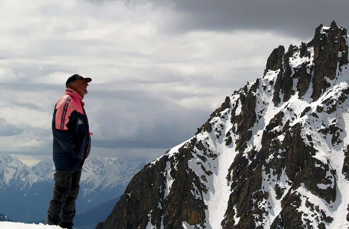 |
- Meteo: you can find all the needed informations at the official site of the Valle d'Aosta Region:
- Valle d'Aosta Meteo
Books and Maps
- "Guida del Monte Emilius", di Osvaldo Cardellina Editore in collaborazione con il Club Alpino Italiano Sezione di Aosta, Dicembre 1978.
- "Guida dei Monti d'Italia – Emilius Rosa dei Banchi Parco del Mont Avic" di Giulio Berutto e Lino Fornelli - Club Alpino Italiano/Touring Club Italiano, Marzo 2005.
- "Guida delle Alpi Occidentali" di Giovanni Bobba e Luigi Vaccarone C.A.I. Sezione di Torino Volume II (parte II), 25 Maggio 1896.
- "80 itinerari di Escursionismo Alpinismo e Sci Alpinismo in Valle d'Aosta", di Osvaldo Cardellina, Ed. Musumeci, Giugno 1977 (in Italian); seconda Ed. Luglio 1981; terza Ed. Luglio 1984; (in French), prima Ed. Febbraio 1978; seconda Ed. Marzo 1980.
- "Diari Alpinistici" di Osvaldo Cardellina e Indice Generale accompagnato da Schedario Relazioni Ascensioni 1964-2019 (inediti).
 |
 |
 |
- Kompass "Gran Paradiso Valle d'Aosta Sentieri e Rifugi" Carta turistica 1:50.000.
- L'Escursionista "Conca di Aosta-Pila-Monte Emilius" Carta dei sentieri (n° 4) 1:25.000.
- Hapax "Les Sentiers Comunità Montana Monte Emilius", Luglio 2000 1:25.000.
- Enrico Editore Ivrea-Aosta "Gruppo del Gran Paradiso" 1:50.000.
- I.G.C. Istituto Geografico Centrale, Torino "Carta delle Passeggiate ed Escursioni in V.D.A. Conca di Pila-Gressan, 1:20.000.
External Links
- More about Emilius Another description with 40 shots, 6 panoramas and a "handmade" map, about Emilius.
- Pila web-site Pila, the famous winter station, has an active life even in summertime. In this link, you'll able to find time schedule for Chamolè Chair Lift.
- REGIONE AUTONOMA VALLE D'AOSTA the official site.
- FONDAZIONE MONTAGNA SICURA Villa Cameron, località Villard de la Palud n° 1 Courmayeur (AO) Tel: 39 0165 897602 - Fax: 39 0165 897647.
- A.I.NE.VA. (Associazione Interregionale Neve e Valanghe).
Useful numbers
- Protezione Civile Valdostana località Aeroporto n° 7/A Saint Christophe (Ao) Tel. 0165-238222.
- Bollettino Valanghe Tel. 0165-776300.
- Bollettino Meteo Tel. 0165-44113.
- Unità Operativa di Soccorso Sanitario Tel. 118.