It seems logical to me, but, all in all, there is a valid reason for supporting this purpose of talking about different experiences gained over the years in frequenting the mountains. Because here we will talk about everything and nothing, about mountains that seem and are not, about mountaineers who seem more like wanderers than climbers. Everything and nothing. Whoever wants to follow us. Otherwise you change the page. Unlike my
Friend Vid Pogachnik who in
"Portraits Of Dolomites Mountains" writes in the its
The PURPOSE of December 04th, 2020: "The idea of this page is to present the wonderful Dolomites mountains on a map - by hundreds of pictures which can be found on the web. You can see how each mountain looks like by up to 8 pictures, showing it from the sides of 8 principal directions of windrose. Finding new representative pictures, this collection will grow.", we, who are much less good with computers and, I would say, technically scarce will be satisfied with a more limited objective. But that is important to us. But then he too must take refuge on October 2, 2021 in
"Huda Luknja Caves System", because the world is made up of immense things, but also of small things equally important: it is a transit from Heaven to the Cave and vice versa ...
Oggetto personalizzato quando non esiste un tipo di oggetto valido per ciò che si desidera inviare: così risulta la specificazione di questa tipologia di pagina su SP in quanto a questa voce.
Mi sembra logico, ma, tutto sommato, una valida ragione sussiste per assecondare questo proposito di parlare di esperienze diverse conseguite negli anni nella frequentazione dei monti. Perché qui parleremo di tutto e di niente, di montagne che sembrano e non sono, di alpinisti che sembrano più dei vagabondi che non degli scalatori. Di tutto e di niente. Chi ha voglia ci segua. Altrimenti cambi pagina. A differenza del mio Amico Vid Pogachnik che in "Portraits Of Dolomites Mountains" scrive nel suo The PURPOSE del 04 Dicembre 2020: "L'idea di questa pagina è di presentare le meravigliose montagne delle Dolomiti su una mappa - con centinaia di immagini che si possono trovare sul web. Puoi vedere come appare ogni montagna da un massimo di 8 immagini, che la mostrano dai lati delle 8 direzioni principali della rosa dei venti. Trovando nuove immagini rappresentative, questa collezione crescerà.", noi, che siamo molto meno bravi con il computer e, direi, tecnicamente scarsi ci accontenteremo di un obiettivo più limitato. Che però ci sta a cuore. Ma poi anche lui si deve rifugiarsi il 2 di Ottobre 2021 in "Huda Luknja Caves System", perché il mondo é fatto di cose immense, ma anche di piccole cose parimenti importanti: é un transito dal Cielo alla Caverna e viceversa ...OVERVIEW Un angolo di paradiso tra piccole montagne sconosciute / A corner of paradise among little unknown mountains
![]() Not all mountains are equally famous and, among the lesser-known ones, there are also completely unknown ones that not even the various Maps or the Cards on the market do not even deign to no mention.
Not all mountains are equally famous and, among the lesser-known ones, there are also completely unknown ones that not even the various Maps or the Cards on the market do not even deign to no mention.
Not for this reason they are less important for those who have frequented and lived them, perhaps discovering them and making them come out of anonymity and then, with the passing of time, become, if not fashionable, at least frequented. At least by those who love the hidden corners of the mountain. Those less visible, but capable of reserving unusual and unexpected emotions. We have already talked about some of them in
SP , others we will discover along the way. Differentiating the orographic and hydrographic right side with respect to the River of Dora Baltea, as well as in longitudinally perspective from West to East. In this first page or page addressed to
"A corner of paradise among little unknown mountains / A" we will deal with the mountains above the Municipalities of Roisan, Aosta, Saint Christophe, Quart, Nus and Chambave. Some are small peaks with some toponyms, others are listed but not named and still others do not possess either of these attributes. But they exist and are Mountains. We visited them in a very distant time that makes them relive in our mind. Surely they are mountains very often forgotten by God and by men, but not by us who have frequented them from an early age and on which we left our Spirit imprinted: a Soul that has distinguished our small businesses and adventures, but which remain forever engraved in our nostalgy. Many will still go up to make the
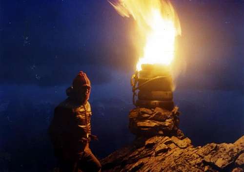
"Fires of Peter and Paul" on the nearby Summits of Becca di Roisan and Becca di Viou, responding to the calls of those lit on the Punte Chalignes, on Mont Saron and, on the other side of the Dora Baltea, from Becca di Nona, from Emilius and, sometimes from Becca di Seneva; but, for now, no one has come back to do the same on the Becchi di Fana. Each of us possesses the yardstick of his own Fantasy, Tenacity and his Memories. We are not talking about Everest, K2, Manaslu, Cho Oyu, Ama Dablam, Acongagua, Denali, Illimani, Chimborazo & Ruwenzori and also even the Elbrus, Mont Blanc, Rosa, Matterhorn, Gran Paradiso or even the beautiful young girl from Grivola.
Instead, they are the "portraits" of very ancient more than old, shattered mountains that the waves of the magmatic underground Ocean have transported up to here and then sculpt them for us in the our Heart ...
Non sempre tutte le montagne sono altrettanto famose e, tra quelle meno conosciute, ne esistono anche di completamente sconosciute che neppure le Carte e le Mappe in commercio si degnano di menzionare.
Non per questo sono meno importanti per chi le ha frequentate e vissute, magari scoprendole e facendole uscire dall'anonimato per poi, col trasscorrere del tempo, diventare, se non di moda, almeno frequentate. Per lo meno da parte di coloro che amano gli angoli nascosti della montagna. Quelli meno in vista, ma capaci di riservare inconsuete ed impreviste emozioni. Di alcune abbiamo già parlato in SP, di altre le scopriremo strada facendo. Differenziando il lato destro orografico ed idrografico rispetto alla Dora Baltea, nonché da Occidente verso Oriente. In questa prima pagina o pagina rivolta ad " Un angolo di paradiso tra piccole montagne sconosciute / A corner of paradise among little unknown mountains / A" tratteremo dei monti soprastanti i Comuni di Roisan, Aosta, Saint Christophe, Quart, Nus Chambave. Alcune sono piccole Cime con tanto di toponimi, altre sono quotate ma non nominate ed altre ancora non posseggono ne l'uno ne l'altro di questi attributi. Ma esistono e sono Montagne. Le abbiamo visitate in un tempo lontano, lontano che le fà rivivere nella nostra mente. Sicuramente sono montagne assai spesso dimenticate da Dio e dagli uomini, ma non da noi che le abbiamo frequentate sin dalla tenera età e sulle quali anbiamo lasciato impressi il nostro Spirito: un'Anima che ha contraddistinto le nostre piccole imprese ed avventure, ma che rimangono scolpite per sempre nella nostra nostalgia. Molti saliranno ancora a fare i "Fuochi di Pietro e Paolo" sulle vicine Vette della Becca di Roisan e della Becca di Viou, rispondendo ai richiami di quelli accesi sulle Punte Chalignes, Sul Mont Saron e, dall'altra parte della Dora Baltea, dalla Becca di Nona, dall'Emilius e, qualche volta dalla Becca di Seneva; ma, per adesso, nessuno é più risalito a fare i medesimi sui Becchi di Fana. Ognuno di noi possiede il metro della propria Fantasia, della Tenacia e dei suoi Ricordi. Non si tratta dell'Everest, dell'Ama Dablam, dell'Acongagua, del Denali, dello Illimani, Chimborazo e neppure dell'Elbrus, Monte Bianco, del Rosa, del Cervino, del Gran Paradiso e nemmeno della bella giovinetta della Grivola. Sono invece i "portraits" di antiche, vetuste, frantumate montagne che le onde del magmatico Oceano sotterraneo hanno trasportato fino a qui per poi scolpirle a noi nel Cuore ... Little unknown mountains
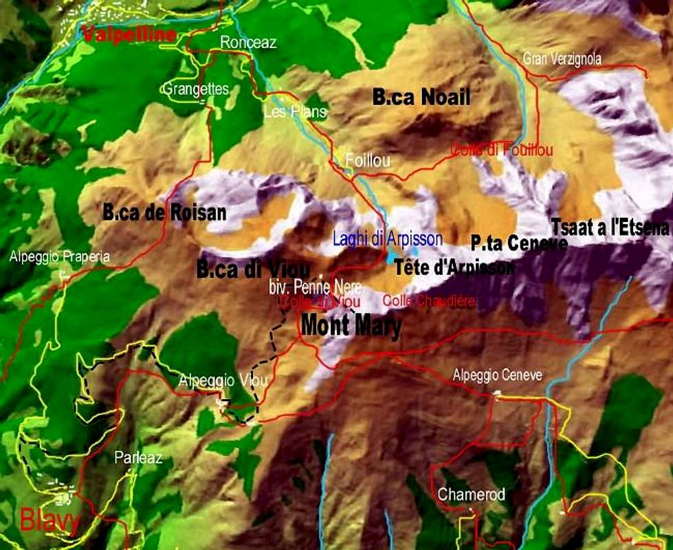
About these summits and relatively to the watershed between Coumba Freide into the Gran San Bernardo Valley in West and Valpelline Valley (North) we find:
A)- Punta di Valfreyde
(2.683 meters) also
Tête du Val - Valfreyde, above the Municipalities of Valpelline (
960m; Baraques de Valfreyda Comba or Basin) to the North and of Roisan to the West
(866m).
About these peaks and relatively to the watershed between the Central Valley of Baltea and Valpelline Valley (to the North) with trend from West to East we find:
B)- Becca di Roisan
(2.546 meters) also
Becca di Pechenville, above the Municipalities of Valpelline (
960 meters; always "Baraques de Valfreyda" Comba or Basin) to the Northwest and of Roisan to the West
(866m).
Becca di Blavy (2.508 meters), or identifiable in the former Altitude
2.494 in I.G.M. located on the ridge-watershed just to the East in respect of previous Becca de Roisan. Then the most impressive and elevated
Becca di Viou (2.856 meters) with from Becca descent to the homonymous and important Pass (2.696/8m), near which the new (2005) "Penne Nere" Bivouac (
2.730 meters; the only one in all into this Southern area) has recently built into the small mountain range, near a rocky and jagged appendage then precipitating to the North above Lake Arpisson
(2.482m) the only one of the entire small subgroup, known as
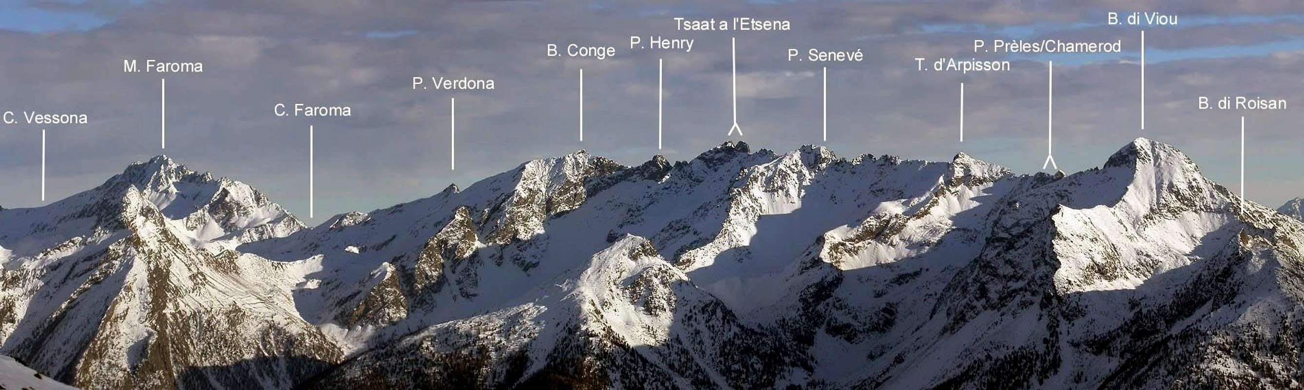
Mont Trembloz (about 2.735 meters), toponym, according to Abbé Joseph Maria Henry, derived, by dialect or "patois" language of Aosta Valley, from the name aspen. Then the watershed rises in the corpulent
Mont Mary (2815 meters) or locally called by the inhabitanys
Mont Saint Joseph, dominating the two Municipalities of Saint Christophe and Quart, and continues towards the Northeast forming a whole series of small points and turrets interspersed with various collars, actually scarcely useful for transit and in practice little or no at all frequented, as indeed the same points formed by rocks difficult to view from below, with bad and brittle rock and mixed with rather dangerous grassy sections. It should be noted that this stretch of the watershed ridge, at least as regards the Becca di Viou-Mont Mary liaison, is the most popular of the entire chain both for the ease of ascent of these two peaks, and because the intermediate Colle di Viou is a destination for easy, safe and very popular passage between Comba di Blavy and the opposite Valpelline, so much so that an Inter Vallivo (Inter Valleys) path signed with the
n ° 102 goes up from the Municipality of Roisan, descending towards the Arpisson Valley. As far as Mont Mary is concerned, it should be emphasized how it can be a beautiful ski-mountaineering trip starting from the Chamerod's little Hamlet and, through the Comba di Senevé, ascending its Southeast side; even the snowshoe hike up to Alpe di Senevé is quite pleasant and rewarding with splendid views of the Monte Emilius Group opposite. This part of the ridge is hardly known by mountaineers and hikers, while the watershed ridge proceeding towards the East, and which we will talk about immediately below, is scarcely frequented, so much so that the ascents can be counted on the fingertips of the hands; it is aimed at adventurous spirits, who like to get out of the usually frequented paths and with high-sounding names; however, it offers emotions and solitudes that are increasingly unavailable in the mountains. And all this just a stone's throw from the neighbor several towns and even by Aosta ! Lately, according to the new fashions, a
"Vertical" race has been instituted, which from the city of Aosta climbs the Southern ridge or, better, n imposing buttress with
over 2.000 meters of altitude difference. Everyone wants to have fun and how can ... Then, starting from Mont Mary, with a direction from the Southwest first towards the East and then Northeast towards the important Colle di Saint Barthélemy and finally from the Becchi di Fana in the South-Southeast up to the Croix de Fana, the progressive order of which is the following: Col Chaudière Sudovest
(about 2.735 meters) or, if desired, and perhaps better, Colle del Mont Mary, being more appropriate to it; small detrital saddle between the Northeast Crest of Mont Mary and the little Punta di Chamerod; of elementary access on the Southern side for rocks and fine detritus, it descends more steeply towards the North above the small Arpisson Lake
(2.482m) and is not useful for the crossing between the Senevé's Basin or "Conca" and the Arpisson small and deep Valley, being preferable the Northeast Col, also really scarcely frequented, if not by isolated and sporadic hunters, which, in truth, we have never seen in the last half century.
Punta di Chamerod (about 2.752 / 54 meters) that takes its name from the underlying locality formed by some renovated buildings, up to the early seventies consisting of old rascards or wooden buildings suspended by some small pillars on a stone base, as per informations from a local shepherd in the summer of 1971. It constitutes a small peak not quoted nor named on any paper, manuals or mountain books and no. It is the natural extension of the Northeast Crest of Mont Mary, forming almost a pivot, exactly at the point where it bends decidedly towards the East reaching a a consecutive series (precisely three) of small elevations. While on the Northwest side it falls with a short
(about 140/50 meters), yellowish and almost vertical wall on the underlying Lago di Arpisson into the Arpisson Valley in Valpelline. Ascended, perhaps for the first time, by Osvaldo Cardellina and Marco Périer on March 30, 1969 in crossing from Becca di Viou and back to it and also traveled in winter on February 23, 1975 by Osvaldo Cardellina, Marco Cossard and Giuseppe Lamazzi in an ascent without skis or even snowshoes, starting from the Village of Blavy
(1.475m) and crossing on the ridge towards Mont Mary and Punta di Chamerod, identical return and extension to Becca di Viou. Chamerod Carving
(about 2.740 / 2 meters); it takes its name from the neighboring point as well as the homonymous point, resulting in a small breach between it and the more
Les Prèles Western Point (about 2.750 / 52 meters) . Easy to access from the South enough wide face, it has a difficult slope in North side, in practice twin and parallel to that of the adjoining Punta di Chamerod with which it joins at the bottom but less than two thirds high and to a lesser extent when viewed from the Northwest, for which transit is not recommended and certainly not easy, as it develops in a small wall of
about 150 meters wedged between the two rocky ribs coming from the homonymous point and from that Pointe of Les Prèles; it is made up of broken rocks and quite steep and very exposed to falling stones.
Punta delle Prèles also
Preyes or even
Preilles (2.746 / 48 meters approximately) is the small and double, almost bifid, western summit and
2.750 / 1 meters the more jagged Estern one. Immediately to the East of the previous hill and point, it is formed by a series of small, not very evident asperities and composed of smooth rocks, but fractured and not too difficult to climb on the South side. The same considerations as for the Punta di Chamerod with a fairly easy with ascent, also in this case probably for the first time, by Osvaldo Cardellina and Saverio Cusumano on September 03th, 1971, crossing from Mont Mary and back to it, as well as subsequent crossing to Becca di Viou. The "Intaglio" also Notch of Les Prèles
(2.738 / 40 meters approximately) takes its name from the two pins of the same name as a tiny notch placed between them with the same considerations as for the previous breach, but the difficulties of the route are even more demanding and dangerous with rocks steep overhangs at times of the residual tongues of snow.
Tête d'Arpisson also known locally as
Pelon de Quart (2.856 / 57 m); it consists of a pyramid with three crests: two are located along the southwest / northeast axis on the watershed crest, while the third cove, always rocky, towards the north-northwest above the Fouillou Pass
(2.437 m). First ascended by Abbé Joseph Maria Henry alone on 19 August 1905; the first winter was carried out on 02 March 1975 crossing from Punta di Chamerod-Punta de Les Prèles- Col Chaudière Northeast and final for the Southwest Ridge, by Osvaldo Cardellina, Marco Cossard and Giuseppe Lamazzi starting from Alpe di Chamerod (1.614 / 5 m), with the same path downhill in the opposite direction. Then we find the
Arpisson's Saddle (about 2.865 meters); wide and long saddle between the Tête d'Arpisson and the Altitude
2.888 meters, the maximum depression of which is closer to the latter; of treacherous access due to the large amount of grass existing on the rocks of the abrupt and wild Southern Side, even from the North it has a detrital side of crushed rocks, so much so that it is inadvisable on both sides and practically nothing practical, it is more a passage for expert and adventurous hunters than not a usable and very convenient pass between two vallons.
Altitude or Quota 2.888 meters, also recognizable as
"Gendarmes of Senevé" or else even as, given the form as a kind of friars folded in prayer,
"The Senevé's Penitents", is formed by a series of towers and turrets of various sizes; located at the Eastern end of the Northeast Crest of the Tête d'Arpisson which, after a pseudo-straight section, forms four characteristically curved protuberances much more evident and, after a tiny notch, rises to a small antecima and to the highest point, also 'they dangling. The subsequent Collar
2.850 meters is constituted by a double notch at the base of the East-Northeast Crest, always at the same altitude of
2.888 meters, at the turn of which an elegant pyramid rises. Its Northern side descends towards the small Comba di Fouillou, secondary and to the east of the Vallone d'Arpisson in the southern Valpelline, and is formed by steep ribs of broken rocks, while to the South it drops with a south-southeast direction towards the Comba di Senevé a clear and fairly steep, but easy, detrital gully; the same was probably used by the Quendoz-Jorrioz roped consortium in the summer of 1972 to begin the crest crossing up to Colle di Fana. The path of the rocky strip immediately to the left (West) of the same is different, which presents a not easy climb covered on a single occasion. First repetition or second ascent of Summit Osvaldo Cardellina and Alessandro Cardellina, (July 18th, 2005), from Chamerod Village towards the Quota
2888 meters, after the first ascent on Southern Face of the same, through before the Western Crest and after by Northwestern Face, in ascent and in descent, during the crossing up to the Punta di Senevé; in descent S-SE Rib to Senevé or Cénevé Alp. This peak, in addition to the 1972 and 1992 crossings, was therefore also climbed along the South Face, formed by steep rocks and often covered with grass. Start in a channel of broken rocks below the perpendicular and continue along it with a moderate slope (50°) leaving on the right (East) two rocky promontories surmounted by a little balconies. In the final part the slope increases considerably, giving three exit opportunities: In the final part the slope increases considerably, allowing three exit out opportunities:
a) - continue on the right or Northeast to reach a small shoulder and from this to the Summit (II°/II°+/III-) ;
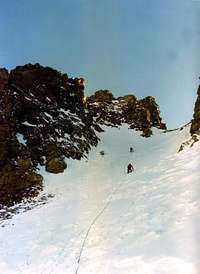
b) - deviate to the left or Northwest reaching a steep rocky chimney with which it ends (II°+/III°-/III°/III°+). Finally
c) - the possibility of going out on the Top directly by climbing the short but somewhat steep terminal yellowish wall (III°-/III°+/IV°-). We must proceed with great caution, because the rock is fragile and almost never good; furthermore, equal attention must be paid to the possibility of falling stones. This climb has not been repeated and in any case it is not recommended; it is better to proceed along the two crests of the watershed, which in themselves already require caution and attention. Always for the same reasons. North side is simpler and more affordable, which offers the possibility of ski-mountaineering ascents, possibly leaning on a breach to the right (West) of
"Gendarmes" or Eastern Senevé's Pass, while further West, after three less accentuated elevations, as well as close to the
Tête d'Arpisson, is the Seneve'S Occidental Col. In general, this long part of the ridge, which joins this last to the
Altitude 2.888 meters, consists of a large inlet or
Arpisson's Saddle (2.865 meters approximately) which can vary in altitude from West to East by
2.865 / 7 up to the 2.875 / 60 meters approximately.
"Campanilino of Senevé" also
"Senevé's" Spires", even
"Senevé's Bell Tower" (about 2.875 / 77 meters); slender and tiny pyramid, it is proposed to call it "Campanile di Senevé", from the name of the basin or comba below. It was first climbed by Osvaldo Cardellina on 11 October 1992, in the long and exhausting crest crossing from Becca di Roisan to Croix de Fana; the 1972 Quendoz-Jorrioz roped rejected it to the right attacking on the saddle immediately to the East or Eastern Collar of Senevé. The second ascent or first repetition is again carried out by Osvaldo Cardellina with his son Alessandro on 18 July 2005 starting from the ancient Village of Chamerod, ascending to the Les Preilles and Senevé Alps and through the first ascent of the South Face of Altitude
2888 meters also
"Gendarmes de Senevé"; then descent to the East Crest of the same and ascent to the Bell Tower always with the route of the first ascent (West Crest and final crossing on the Northwest little Wall); on this occasion the party roped continued on the Southwestern Crest of Punta di Senevé and then descended for the rocky-grassy Rib S-SE as well as a descent always the same as that of the ascent from and to Chamerod. There is no knowledge of other ascents or various routes by other groups, while it is more than logical to suppose that the ascent of this small spire does not represent an end in itself, but only a point of passage during the West / East crossing and vice versa.
Punta di Senevé (2.928m); from the "Colletto" Orientale di Senevé (Senevé's Eastern Collar) a short but steep and bumpy Southwestern Ridge climbs, so much so that Valpelline's Abbé Joseph Maria Henry considered it impracticable. It was climbed for the first time by the 1972 roped consortium, partially covered downhill and ascended from Punta di Senevè again in the same year and retraced in the crossing just twenty years later, as well as in the shortest journey of July 18th, 2005 from Altitude
2888 meters or called
"Senevé's Gendarmes" and also known as
< b>"Senevé's Penitentes". Less difficult than expected, it requires caution for the quality of the rock, somewhat crumbled with suspended material. The mountain, the Summit of which is projected and almost "extended" to the West, has two sides; one to the south of broken rocks sprinkled with grassy stretches which, with a spur just outlined and ending on the Eastern Crest a short distance from the summit at a Northern Ante Top
2.926 meters, can constitute the Via Normale. It was climbed on 8 October 1972 by Osvaldo Cardellina and Camillo Roberto Ferronato uphill and downhill starting from Chamerod Alp, in what constitutes the second or first ascent of the mountain (the exact date is missing in the other ascent of 1972). On this occasion the Southwest Ridge was almost completely covered downhill and then climbed. Also with this itinerary the first winter ascent by Osvaldo Cardellina took place, with a solitary ascent on 30 December 2007 and even the descent of July 18th, 2005, after the crossing West / East from
"Senevé's Gendarmes" /
"Senevé's Penitentes" or else
Quota 2.888 meters and
"Senevé's Bell alsoTower", after the traverse. The other side, facing North, is made up of not very steep rocky ribs and with broken sections up to the terminal turret formed by more exposed rocks; it is certainly a suitable side for the practice of ski-mountaineering in the winter season. After the point and towards the East, the dividing ridge stretches out to form the little evident Eastern Senevé's Pass
(about 2.910 / 15 meters). This results as a wide saddle placed between the homonymous peak and the jagged Altitude or Quota
2.945 / 50 meters. Passage of very little use and probably never used. From the South go up with the South-Southwest Spur of the Punta di Senevé, then cross to the left (West) in the final part; or attack at the base of the Altitude
about 2.945 / 50 meters starting the climb in a bottleneck formed by rocky ribs leading to the upper and more linear slope, and with a long diagonal to the left, on broken rocks often covered with grassy slopes, reach it. On the North side, go up through crushed rocks mixed with detritus. This too is somewhat inadvisable, especially in presence of abundant or simply fresh snow. For expert hunters and brave hikers, but also for those who love even more a bit of research and adventure.
Altitude or Quota 2.945 / 50 meters, which could be called
"Third Flat Head of Tsaat à l'Etsena", but, perhaps and better, it would suit the toponym of
Testa di Verdzignola or else
Testa di Verdzignolaz being at the top of the valley of the same name as well as opposite dating from the Valpelline wild Valley (above the Villages of Prèle and Vesey as well as between the Municipalities of Valpelline and Oyace and the Alpages of Grand Verdzignola and the Pastures of Verdzignoletta). Summing up, from the Punta di Senevé the crest-watershep continues almost straight, easily reaching this rounded and almost flat level; "obscured" by the two neighbors Summits of Tsaat à l'Etsena. This is ascended in the autumn 1972 crossings and in the solitary one from Becca di Roisan to Croix de Fana on 11 October 1992, while Abbé Henry in his ascent to the Western Punta of Tsaat à l'Etsena on 13 July 1923 discarded it just on the left going up (East), after the climb on the Verdzignola side. Then you reach the "Colletto" or Collar
2.930/35 meters; at the base of the Western Edge of the West Tip of the Tsaat at l'Etsena; as for the previous altitude, reached by crossing West / East. Its slopes are equally inadvisable due to the poor quality of the rock, covered with grass on the Southern side and with broken rocks, debris or remains of snow on the one exposed to the north with similar if not identical paths for both and with the same considerations as above.
Western Tip or Summit of Tsaat at l'Etsena (2.971m), considered to be the highest in
"Pennine Alps Volume II" , 1970, pages 371/3, into the "Collana dei Monti d'Italia" C.A.I. / T.C.I. Edition, instead a few meters lower than Punta Est also Eastern Top, valued at
2.967 meters against
approximately 2.974 / 5 meters in reality, as per various personal findings on site (
see various photos). Ascended by Valpelline's Abbot Abbé Maria Joseph Henry, alone, on 13 July 1923, who reached it, as just mentioned above, from Northern side of opposite Comba Verdzignola in Valpelline, gaining its watershed crest, presumably, at
"Colletto" also
Collar 2.930 / 35 meters, if you like, identifiable as the Western Hill of Tsaat à l'Etsena, bypassing the Western "Spigolo" or Corner and ending for the short Southwest Face, where the Quendoz-Jorrioz roped consortium also crossed in autumn of 1972. The "Spigolo" Occidentale or Western Corner was instead climbed entirely on the edge of the crest in the 1992 traverse, starting from the little Becca di Roisan
(2.546m), above the Municipality of Roisan, and arriving at the small but wide Croix de Fana
(2.212m) above the three (Fonteil, Avisod and Porsan) Hamlets of Trois Villes, carried out by myself alone. Also climbed in winter on December 22 by the Cardellina-Ferronato-Lamazzi roped consortium, which used the Eastern Spigolo or Edge for the ascent, of very steep and fairly difficult rocks, passing more to the right or North of the itinerary carried out in descent by the Aosta's roped Renato Quendoz-Jules Jorrioz and joining this only in the last 5/6 meters, due to the presence of very much verglass on the rocks. The descent took place, after
forty meters directly on the Southern Face, with a long diagonal through diagonal descent on the South-southeast Side. Another route was opened by Osvaldo Cardellina, alone, on September 26, 1999, who on the same day climbed directly to the Southern Face, descended along the same slope above and then also climbed the South Face of Punta Est. Colle di Tsaat at l'Etsena
(2.910 / 15 meters approximately); placed between the two twin Summits, it was so baptized by Abbé Henry (various bibliographical references and RM CAI 1913, pages 98/100 with report and photos), even if, even if reached from the Southern side or by crossing West / East, it never appears to be been crossed from South to North, or in a crossing between the Valloni of Combe di Senevé and Verdzignola. Considering the
"Colletto" or else
Collar , but better a
Carving 2.930 / 35 meters as the
Western Col de Tsaat à l'Etsena, this pass , as mentioned, although it cannot be used or at least crossed, it should be called
Eastern Pass of Tsaat à l'Etsena or Eastern Pass of Tsaat a l'Etsena
(about 2.910/15 meters) the next notch placed between the two peaks of Tsaat. In reality, both simply act as a crossing point during the crossing aqlong the watershed, or as a starting
"pitch" for subsequent climbs. This Summit, together with the homologous
East Tip (2.967 meters or better about 2.974 / 5 metres), constitute the most "climbing" sector of the whole subgroup together with the various possibilities they offer the walls of
Becca di Viou (2.856m). Unfortunately, the considerations already expressed on the quality of the rock are valid for the entire sector of this small subgroup.
Punta Orientale or Eastern Top (2.967 meters or better 2.974 / 75 meters approximately , actually a couple of meters higher than the previous one, as per on-site analysis and attached photographic evidence; climbed by Abbé Joseph Maria Henry, alone, on 2 September 1912, after an attempt of the same retreat on the nearby Becchi di Fana on 12 August 1912 for the Southern "Crestone". This attempt served as an acknowledgment of the itinerary necessary to make the first absolute ascent of
Tsaat à l'Etsena to Punta Est, erroneously considered lowest to be at the time. A first winter attempt on this route was also attempted by the Garzotto-Cardellina consortium on 6 January 1969 starting from Trois Villes, but ran aground, due to the presence of too high snow, not too far from the Croix de Fana, and because without at least dotation of snowshoes. The first winter was instead realized, always with the same starting point, by the Cardellina-Cossard-Lamazzi-Ferronato roped consortium on January 26th 1974; on this occasion the great channel south of the Colle di Fana was used, to then continue cutting the East side on the right and ending in the final stretch of the North-Northeast Crest, a route already used by the Abbé for the first ascent starting from Colle di Saint Barthélemy, but passing below the Punta
2.918 meters, later dedicated to it. Three days later the first three also made the first winter ascent to the Becchi di Fana, with the same itinerary up to the Fana's Pass and then diverted to the North side of the same. The complete ridge up to the Saint Barthélemy Hill was climbed by the Cardellina-Lamazzi roped party on 20 August 1978, which then continued up to
C)- Becchi di Fana (2.945 meters the Western Antecima and, on average, 2.948 / 51 the other roughness), crossing all five to subsequently descend to Comba Dèche via the
Colletto 2.940 meters; this route is indicated as normal route by Gino Buscaini in
"Alpi Pennine Vol. II °", pages 572/3 with sketch n ° 79, considering the ascent of the Colle di Fana, more than a hill, a rocky Alpine pass, quite dangerous, just the opposite, considering in any case dangerous the climb on both fronts especially in the presence of abundant snow. But between the Eastern Top of Tsaat à l'Etsena and Becchi di Fana there is another passage, almost an alpine hill, much more important:
Colle di Fana (about 2.880 meters); between the East Point of Tsaat in Etsena and
Western Antecima about2.945 meters of Becchi di Fana, with all the previously mentioned considerations. The first ascent is unknown to this, more than a hill, an alpine rocky pass; while the first winter climbing took place on the occasion of the winter ascent at Eastern Summit, followed on 29 December of the same year by that of Becchi with the same name. From Punta di Tsaat to the East Etsena an important buttress winds first in a Northeastern direction, first forming a secondary notch that descends abruptly to the West followed by two square and cut-off turrets; then a very sharp notch that descends to the Northwest, very steep and recessed, towards the Comba di Verdzignola (z) in Valpelline and with less exposure towards the Southeast on the Comba Dèche (it could almost dutifully be called
"Intaglio dell'Abbé" or else
"Abbot's Nick"; about 2.895 / 2.900 meters) preceding an isolated and small Summit, know as
Punta Joseph Maria Henry (2.918m). As with all the peaks of this watershed, starting from Punta di Chamerod-Punte delle Preles-Tête d'Arpisson and therefore excluding Becca di Roisan, Becca di Blavy, Becca di Viou, Mont Mary, climbs are very rare and this also applies to the several Becchi di Fana; despite the fact that the South "Crestone" is easy and presents a
"solar" climb. The speech of the crossing of the same is very different which, analyzed by the Western Antecima or Ante Summit, appears discouraging, even if in reality it is easier than expected. Certainly in these parts it is not to be expected to meet crowds of Tourists, but also of the much-cited Hunters of the Ibexes & Chamoises (this is especially true for the compilers of Books or Alpine Guides who, when they no longer know who to appeal to, always find the shortcut of these strong & hard
"Hunters of Past Time"), who almost always seem, when it is not known who first passed through those parts, to visit the Alps in the most inaccessible and unknown places, do not have we ever noticed any trace ... except from the parts of the
"more docile & meek" Becca di Viou. Let hikers reassure themselves, because, in over half a century, not a single one has ever been seen in these parts ...
Punta or Pointe Joseph Maria Henry (2.918m): the watershed crest continues towards the Northeast and, after an insignificant notch, reaching a more marked depression, that it could be indicated as
Col Conge (2.871 meters) or Col Abbé Joseph Maria Henry in honor of the same explorer of this neglected mountain range , with the same consideration as the previous one at about its climbing, so much so that in the first ascension carried out on August 20, 1978 by Aosta's Mountaineers Osvaldo Cardellina with Giuseppe Lamazzi, starting from the Hamlet of Fonteil (Trois Villes) just at the beginning of Comba Dèche and through the Colle di St. Barthélemy, completely no sign or signal was found during the ascent and on the Summit passing. On this occasion the complete traverse was carried out passing through the NE Crest of Becca Conge at an altitude 2918 meters or Punta or Pointe Henry, at Estern Summit of Tsaat à l'Etsena
(2.871 meters) via the Northeast Crest with descent to Colle di Fana and round trip crossing of all the five elevations of Becchi di Fana (
Western Antesummit 2945 meters,
Collar 2925 meters,
Central Beak 2951 meters,
Second Beak 2945 meters,
Third Beak 2940 meters,
Fourth Beak or more
Eastern 2938 meters). Finally, return to next
Collar 2925 meters and descend via the Northern snowy and detritic Couloir and then Northeast to the Comba di Fana (the one recommended by Gino Buscaini in
"Alpi Pennine Volume II ", 1970, pp. 571-3 with sketch on page 572). I have no other ascents, except one carried out by the Mountaineer Federico Rossetti of Parma with lonely climbing on September 24th, 2018, which, always arriving from Fonteil Hamlet (
1.426 meters; one of the three of Trois Villes Fraction) through the middle part of Comba Dèche, entered the collar between it and Becca Conge and then continued with the itinerary of the first climbers, but proceeding just below the ridge on the Eastern side, through which he made also the descent (see
"Cervino Valtournenche and Valle di Saint Barthélemy", itinerary 004, pages 47-9 with color photos and layout; Edit. IDEAMONTAGNA EDITORIA E ALPINISMO, 1st edition July 2019). At present there are no other notices or at least no knowledge of other ascents, which, however, are very rare in these parts.
Becca Conge (2.954 / 57 m) , the highest of this second stretch of watershed ridge dividing Valpelline from Saint BarthélemyValley up to the very important Col of the same name
(2.645 / 6 m), which it reaches by unfolding, after the acute carving of North Antecima
(2.927 m), a series of minor altitudes and depressions
(2.918 m, 2.781 m, 2.828 m, 2.765 m, 2.703 m, 2.714 meters). This too appears to be Top sparsely frequented, because it is a little "hidden" and semi-hidden by the slender pyramids of the two Tsaat à l'Etsena as well as by the corpulent mass of Becchi di Fana. Enclosed between the two Southern buttresses that descend from the last mountain and on the opposite side from the pyramid of Mont Faroma, it obtains little space to stand out and to get there you have to climb to the appendages of the latter.That is to the Gran Pays
(2.726m) or to the nearby Becca d'Aveille or d'Avuille
(2.623m); otherwise go up on the other side of the Dora Baltea, towards the plateau of Les Druges (Saint Marcel Municipality), from which you can see the same gradually rise. Like the sun in the morning. Even on the opposite side of the Valpelline it remains little in sight, but it appears to be better known; because from near its Northern Antecima
(2.926 / 7m) it "gives birth" to a North-northwest ridge that descends to Colle dell'Arpeyssaou
(2.492m) where, between Pointe de Lière and Becca Morion, the Bivacco della Lière
(2.423m) has been positioned. But from the valley floor, between Valpelline and Oyace Municipalities, it remains "hidden" and to observe it goes is better from several tablelands below the Punta Fiorio-Mont Clapier-Mont Morion Mountain Chain. Returning to the opposite side, that is to the Saint Barthélemy Valley, it should be observed how the same, positioned in the parallel and long Comba Dèche, belongs to the Quart Municipality, beyond the toponym that identifies the pass. The ascent that is carried out from Saint Barthélemy Col is to be considered as just more than easy and suitable for any type of hiker up to the Antecima
2.926 meters; instead the following notch of
a dozen meters is to be classified as II°+/III°- and in any case it does not preclude the ascent to the Summit, even if it requires some attention in overcoming it. The first winter ascent was carried out by myself on December 28th, 2000, starting from Fonteil Village and using snowshoes up to beyond the St. Barthélemy Pass along the Northeastern Ridge. At the opposite the next crest it rises to the less striking
Punta di Verdona (about 2.868 / 75 meters, depending on different versions), it is easy to climb along the Normal Via or West-southwestern Ridge that climbs and which rises quite linearly from the underlying Saint Barthélemy's Pass between the Dèche to the South and Vessona to the North, opposite Combes or Basins and on the relative watershed and of which the first ascents are unknown. The first climbers of this crest are unknown, certainly the first of the mountain that we can identify here surely in local mountaineers, shepherds or ibexes and chamoises hunters. There are also some routes traced on the Southern Face of which one by unknown mountaineers and a second via by Osvaldo Cardellina and Giuseppe Lamazzi on 01 May 1997; while on the other or Northern side there is a route probably built by Gino Buscaini in the summer of 1970, arriving from Comba di Vessona. Both are more dangerous than difficult routes due to the fragility of the rock and suspended materials. As far as the other two crests are concerned, there is a solitary ascent by Osvaldo Cardellina on the North-Northwest Crest carried out on 31 August 1999, uphill starting from Col Coteau du Fond and another route, but downhill towards Col Faroma and the Valchourda's Pastures, always on the same day by the same mountaineer. This Summit rises not very far on the watershed crest just East of Saint Barthélemy's Col
(2.645m) before reaching the most imposing
Monte Faroma (3073m), which is certainly the most important peak but also the highest of this area overlooking the middle course of the Dora Baltea between the City of Aosta and the Municipality of Nus at the foot of the same (
where our discussion of the already large sector taken into consideration ends): To then continue its run in the direction of the fascinating and elegant
Becca di Luseney (3.504m), at the Northern apex of the underlying Saint Barthélemy Valley. Quite popular peak starting from Colle di Vessona
(2.788/89m), thanks to the ease of its Northeast Crest which, also has a carving followed by a rocky wall (I°+ and II°- on the edge of the ridge) which can be bypassed immediately on the left (South). It has various climbing routes both along the three main ridges, both for how much it girds the crests and for the two opposite walls: Northeast from
Colle di Vessona, West-northwest from
Colle Faroma, 2.741 meters with integral descent from Summit to Col Faroma by Osvaldo Cardellina, solo, June 12th, 1999 and South-southwest from
Col Léché 2.588 meters. This last ridge climbed through the Northwestern Side of Quota
3.038 meters near the Top and final part of Western Crest by Aldo Bonacossa and Benedetto Salvi Cristiano, April 27th, 1917, in ascent from Vessona's Comba or small Valley and event made on integral thread of the crest from Col Léché by the mountaineers A. Gustavo De Petro and Pompeo Viglino, Jun 26th, 1920, in ascent from Léché Alp in St. Barthélemy Valley. Otherwise, in regard to the walls, on the slopes, of which the Southern one, formed by a high wall, gives it the appearance of a Gothic cathedral; into the same a first route with descent on Right or more Eastern Side, by Auguste and Ferdinand Darbellay with the Charvensod's, in this time mountain-carrier (today, more appropriately, he would define himself as an Aspiring Mountain Guide), Grégoire Comé on September 15th, 1895. Furthermore, in more current time, another route, but in ascent, with Direct Via into the Great Central Couloir, by Osvaldo Cardellina, lone, on July 13th, 2008, from Saint Barthélemy-Chaleby Alp. While the opposite, which can be divided into at least two parts with the Northeastern composed by a snowy-detritic couloir between two rocky ribs and the Northwestern with various gullies amongst several always rocky ribs. All with several possibilities and precisely: Northern Slope, more Northeastern Sector by Abbot Joseph Maria Henry, lone, August 09th, 1905, in descent. North Wall through Northern Rib by Osvaldo Cardellina, lone, June 12th, 1999, in ascent from Prarayer and through the long Comba di Vessona. Finally, North-northwestern Face on Northwestern Rib between two couloirs, by always with lonely climb by Osvaldo Cardellina on July 13th, 2008, in descent to Col Faroma and bypassing neighbor Valchourda Pasture. This Northern Face is less high, striking and more "flattened". The first ascent of Mount Faroma is dated 1892 by Captain Albert Casalegno of the Sardinian General Staff, while the first winter ascent was carried out by Aosta's and Torino's mountaineers Massimo Mila, Toni Ortelli, Fulvio Ratto and Enrico Rizzetti on February 2th, 1958. Returning back to previous watershed between Comba of Senevé and Comba Dèche, from the Fana Col instead another secondary branch begins which, after having formed the five Becchi di Fana (
2.951 meters; four plus an Antecima Ovest
approximately 2.945 meters), descends towards South-Southeast to the Central Valley of the Dora until to the three Trois Villes's Villages
(1.391 m) above the Municipalities of Quart and Nus. This long but modestly-appearing buttress forms, along the way, the Passo Alto
(High Pass; about 2.540 meters), and to the South the
D)- North Cornet Top or
Quota (2484m), it is formed by three modest elevations that follow each other in an undulating way after the namesake, quite frequented by shepherds, homonymous
Colle (2.272m), the
Punta dl Cornet Sud or
Altitude 2.306 meters, after the next and not frequented in crossing from Senevé Comba to Dèche and vice versa, due to the steep Western side, the
Colletto (2.226 meters) to end with the
Croix de Fana (2.212m), splendid, large and elongated to the North, balcony positioned like a bursting promontory as advanced viewpoint over the development of a large part of Central Valley of the Dora Baltea.
![]() A proposito di queste cime relativamente allo spartiacque tra la Coumba Freide all'interno della Valle Gran San Bernardo e la Valpelline (a Nord) troviamo:
A)- Punta di Valfreyde (2.683 m)
A proposito di queste cime relativamente allo spartiacque tra la Coumba Freide all'interno della Valle Gran San Bernardo e la Valpelline (a Nord) troviamo:
A)- Punta di Valfreyde (2.683 m) oppure
Tête du Val - Valfreyde, al di sopra dei Comuni di Valpelline (
960m; Comba di Baraques de Valfreyda) Nord e di Roisan
(866m) ad Ovest.
In merito a queste cime relativamente allo spartiacque tra la Valle Centrale della Dora e la Valpelline (a Nord) con andamento da Ovest verso Est troviamo:
B)- Becca di Roisan (2.546 m) oppure
Becca di Pechenville, sopra i Comuni di Valpelline (
960 metri; sempre Comba "Baraques de Valfreyda") a Nordovest e di Roisan ad Occidente
(866 m) .
Becca di Blavy (2.508 m), oppure individuabile nella ex Quota
2.494 metri in I.G.M. collocata sulla cresta spartiacque subito ad Oriente della precedente Becca di Roisan. Quindi la più imponente nonché elevata
Becca di Viou (2.856 m). Dalla Becca discesa all'omonimo ed importante Colle (2.696/8 m), vicino al quale da poco tempo è stato posizionato il nuovo (2005) Bivacco Penne Nere
(2.730 m; l'unico in tutta la piccola Catena Montuosa), presso un'appendice rocciosa e frastagliata poi precipitante a Settentrione sopra il Lago di Arpisson
(2.482 m) l'unico dell'intero piccolo Sottogruppo, conosciuta come
Mont Trembloz (2.735 metri circa), toponimo, secondo l'Abbé Henry, derivato, secondo il dialetto o "patois" valdostano, dal nome pioppo tremulo; quindi la cresta spartiacque si rialza nel corpulento
Mont Mary (2.815 m); oppur detto in loco
Mont Saint Joseph, dominante i Comuni di Saint Christophe e di Quart, e prosegue verso Nordest formando tutta una serie di puntine e torrette inframezzate da vari colletti, per la verità scarsamente utili al transito ed in pratica poco o del tutto non frequentati, come d'altronde le punte medesime formate da rocce ostiche alla vista dal basso, con roccia non buona e friabile e frammista a tratti erbosi piuttosto pericolosi. C'é da osservare come questo tratto di cresta spartiacque, almeno per quanto concerne la liaison Becca di Viou-Mont Mary, risulta esser il più frequentato dell'intera catena sia per la facilità di salita di queste due cime, sia perché l'intermedio Colle di Viou é meta di passaggio facile, sicura nonché molto frequentata tra la Comba di Blavy e la Valpelline, tanto ne é che dal Comune di Roisan risale un sentiero Inter Vallivo siglato con il
n ° 102 , discendente verso il Vallone di Arpisson. Per quanto concerne il Mont Mary, da sottolineare come possa costituire una bella gita di sci-alpinismo partendo dal Villaggetto di Chamerod e, attraverso la Comba di Senevé, risalita del suo Versante Sudest; anche la gita con racchette da neve insino all'Alpe di Senevé é alquanto piacevole e remunerativa con splendide viste sull'antistante Gruppo del Monte Emilius. Questa parte di cresta é veramente poco conosciuta da parte degli alpinisti e degli escursionisti, mentre la cresta spartiacque procedente verso Oriente, e della quale parleremo subito appresso, risulta scarsamente frequentata tanto che le ascensioni posson contarsi sulla punta delle dita delle mani; essa é rivolta a spiriti avventurosi, che amano uscire dai percorsi solitamente frequentati e dai nomi altisonanti; essa regala però emozioni e solitudini sempre più irreperibili in montagna. E tutto questo a due passi dalla città! Ultimamente, secondo le nuove mode, é stato istituita una corsa
"Vertical", che dalla Città di Aosta risale il costone Meridionale con
oltre 2.000 metri di dislivello. Ognuno si diverte vuole e come può ...
Quindi, a partire dal Mont Mary, con direzione da Sudovest prima verso Est eppoi Nordest in direzione dell'importante Colle di Saint Barthélemy ed infine dai Becchi di Fana a Sud-sudest insino alla Croix de Fana, l'ordine progressivo dei quali è il seguente: Col Chaudière Sudovest
(2.735 metri circa) oppure volendo, e forse meglio, Colle del Mont Mary, essendone più appropinquato; piccola sella detritica tra la Cresta Nordest del Mont Mary e la Punta di Chamerod; di accesso elementare sul Versante Sud per roccette e fine detrito, scende più dirupata verso Settentrione sopra il Lago di Arpisson
(2.482 m) e non è di utilità per l'attraversamento tra la Conca di Senevé ed il Vallone dell'Arpisson, essendo preferibile il Colle Nordest, veramente pur lui scarsamente frequentato, se non da isolati e sporadici cacciatori, che, per verità, mai abbiamo visto negli ultimi 50 anni.
Punta di Chamerod (2.752/54 metri circa), che assume il nome dalla sottostante località formato da alcune costruzioni ristrutturate, fino agli inizi degli anni Settanta costituiti da vecchi rascards ovvero costruzioni in legno sospese tramite alcuni piccoli pilastri su di un basamento in pietra, come da informazioni da parte di un pastore della zona nell' estate del 1971. Costituisce una piccola cima non quotata ne denominata su di alcuna carta, manuale o libri di montagna e no. Trattasi del naturale prolungamento della Cresta Nordest del Mont Mary, esattamente nel punto in cui questa piega, formando quasi un perno, decisamente verso Oriente. Mentre sul Versante Nordovest precipita con una breve
(circa 140/50 metri), giallognola e quasi verticale parete sul sottostante Lago di Arpisson nel Vallone dell'Arpisson in Valpelline. Salita, forse per la prima volta, da Osvaldo Cardellina e Marco Périer il 30 Marzo 1969 in traversata dalla Becca di Viou e ritorno alla medesima ed inoltre percorsa anche d'inverno il 23 Febbraio 1975 da parte di Osvaldo Cardellina, Marco Cossard e Giuseppe Lamazzi in un'ascensione senza sci nonché racchette da neve, con partenza dal Villaggio di Blavy
(1.475 m) e traversamento in cresta al Mont Mary ed alla Punta di Chamerod, ritorno identico e prolungamento fino alla Becca di Viou. Intaglio di Chamerod
(2.740/2 metri circa), assumente il nome dalla viciniora omonima punta risultando piccola breccia tra la stessa nonché la
Punta Occidentale de Les Prèles (2.750/52 metri circa). Di facile accesso da Mezzogiorno, presenta un versante ostico a Settenterione, in pratica gemello e parallelo a quello dell'attigua Punta di Chamerod con il quale va a congiungersi in basso ma meno alto di due terzi ed in minor evidenza se osservato da Nordovest, per la quale cosa il transito é sconsigliabile e sicuramente non facile, poiché sviluppantesi in una paretina di
150 metri circa incuneata tra le due costoline rocciose provenienti dall'omonima punta e da quella delle Prèles; é formata da rocce rotte ed abbastanza ripide ed esposte alla possibile caduta di sassi.
Punta delle Prèles oppure
Les Preyes od anche
Les Preilles (2.746/48 metri circa) é la piccola e duplice, quasi bifida, sommità Occidentale e 2.750/1 metri quella più frastagliata Orientale. Subito ad Oriente del colle e della punta precedenti, è formata da una serie di piccole asperità poco evidenti e composte da rocce lisce, ma fratturate e di non eccessivamente difficile salita sul Versante Sud. Stesse le considerazioni come per la Punta di Chamerod dalla salita abbastanza facile con ascensione, anche in questo caso probabilmente per la prima volta, da Osvaldo Cardellina e Saverio Cusumano il 3 Settembre 1971, in traversata dal Mont Mary e ritorno al medesimo, nonché susseguente attraversata alla Becca di Viou. L'Intaglio de Les Prèles
(2.738/40 metri circa) prende il nome dalle due puntine omonime come minuscola breccia posta tra le medesime con le stesse considerazioni che per la precedente incisione, ma le difficoltà del percorso sono ancora più impegnative e pericolose con rocce ripide sovrastanti nonché situato alla base della cresta Sudovest della Tête d'Arpisson; questo passo venne utlizzato per la prima salita invernale di quest'ultima nel 1975, valgono le sconsiderazioni fatte per l'omologo Colle Sudovest o del Mont Mary.
Tête d'Arpisson conosciuta in loco anche come
Pelon de Quart (2.856/7 m); è costituita da una piramidina con tre creste: due sono situate lungo l’asse Sudovest/Nordest sulla cresta spartiacque, mentre la terza cala, sempre rocciosa, verso Nord-nordovest sopra il Colle di Fouillou
(2.437 m). Salita per la prima volta dall'Abbé Joseph Maria Henry da solo il 19 Agosto 1905; la prima invernale è stata effettuata il 02 Marzo 1975 in traversata dalla Punta di Chamerod-Punte di Les Prèles-Col Chaudière Nordest e finale per la Cresta Sudovest, da parte di Osvaldo Cardellina, Marco Cossard e Giuseppe Lamazzi con partenza dall'Alpe di Chamerod
(1.614/5 m), con in discesa lo stesso percorso in senso opposto. Quindi troviamo la Sella d'Arpisson
(2.865 m circa); larga e lunga Sella tra la Tête d'Arpisson e la Quota
2.888 metri circa, la depressione massima della quale é più viciniore a questa ultima frastagliata sommità; di accesso infido per la molta erba esistente sulle rocce dell'abrupto e selvaggio Versante Meridionale, anche da Nord presenta un versante detritico di rocce frantumate, tanto da risultare sconsigliabile su di entrambi i lati e di praticità praticamente nulla, risulta più un passaggio per cacciatori esperti ed avventurosi che non un vero valico.
Quota 2.888 metri, oppure sommità riconoscibile siccome
"Gendarmi di Senevé" ma anche, vista la forma a mò di frati ripiegati in preghiera,
"I Penitentes di Senevé", risulta formata da una serie di torrioni di dimensioni varie. Situata all'estremità Orientale della Cresta Nordest della Tête d'Arpisson che, dopo un tratto pseudo rettilineo, forma, dopo una serie di tre elevazioni meno accentuate, quattro protuberanze caratteristicamente ricurve ben più in evidenza e, dopo un minuscolo intaglio, si rialza ad una piccola antecima ed al punto maggiormente elevato, anch'essi penzolanti. Il successivo Colletto
2.850 metri circa è costituito da un duplice intaglio alla base della Cresta Est-nordest sempre della stessa Quota
2.888 metri, a cavallo del quale si innalza una elegante piramidina a forma di Cervino in miniatura. Il suo Versante Settentrionale scende verso la piccola Comba di Fouillou, secondaria ed ad Est del Vallone d'Arpisson nella Valpelline Meridionale, ed è formato da ripide costole di rocce rotte, mentre a Sud lascia cadere con direzione Sud-sudest verso la Comba di Senevé un fiancheggiante nonché evidente ed abbastanza ripido, ma facile, canalone detritico-terroso. Lo stesso è stato utilizzato probabilmente dalla cordata Quendoz-Jorrioz nell'Estate del 1972 per iniziare la traversata in cresta conclusasi poi insino al Colle di Fana. Diverso il percorso della fascia rocciosa subito alla sinistra (Ovest) del medesimo, che presenta una non facile salita: la medesima venne percorsa in un'unica occasione con la prima ripetizione o seconda ascensione del Campanilino di Senevé da parte di Osvaldo Cardellina ed Alessandro Cardellina in data del 18 Luglio 2005. Con partenza dal Villaggio di Chamerod verso la soprastante Alpe di Senevé e da questa alla Quota
2888 metri, effettuando la prima ascensione della Faccia Meridionale e, dopo discesa al duplice Colletto di Senevé, con seconda salita al Campanile di Senevé tramite la Cresta Occidentale dello stesso, dapprima, per poi continuare sfruttando la Paretina Nordovest. In salita e discesa per quindi proseguire in traversata con la Cresta Sudovest alla Punta di Senevé
(2.928 metri). Infine discesa dalla medesima tramite il Costolone S-SE donde all'Alpe di Senevé oppure Cénevé
(2.199 metri). Questa Cima, oltreché con le traversate dell'autunno del 1972 e del 1992, é stata quindi salita anche lungo la Parete Sud, formata da rocce ripide, infide nonché spesso ricoperte da strati erbosi. Iniziare in un canale di rocce rotte sotto la perpendicolare dalla Vetta e proseguire nel medesimo con discreta pendenza (50°) lasciando sulla destra (Est) due evidenti promontori rocciosi sormontati da balconcini. Nella parte finale la pendenza aumenta notevolmente concedendo tre opportunità diversificate di uscita:
a)- continuare sulla destra o Nordest per raggiungere una piccola spalla e da questa la Cima (II°/II°+/III°-);
b)- deviare sulla sinistra o Nordovest raggiungendo un ripido camino roccioso con il quale si conclude (II°+/III°-/III°/III°+). Infine
c)- tramite la possibilità di arrivare sulla Sommità direttamente scalando la breve, ma alquanto ripida, Parete giallognola terminale (III°-/III°+/IV°-). Si deve sempre procedere con molta cautela, perché la roccia é fragile e quasi mai buona; inoltre si deve prestare altrettanta attenzione alla possibilità di caduta di sassi. Questa salita non risulta essere stata ripetuta ed in ogni caso é sconsigliabile; meglio procedere lungo le due creste di spartiacque, che già di per se stesse richiedono notevole cautela ed attenzione. Sempre per le stesse motivazioni. Più semplice ed abbordabile il Versante Settentrionale, che offre possibilità di salita sci-alpinistica, eventualmente appoggiando su d'una breccia subito a destra (Ovest) dei
"Gendarmi" o Colle Orientale di Senevé, mentre più verso Ovest, dopo tre elevazioni meno accentuate, nonché ravvicinato alla
Tête d'Arpisson, si colloca il Colle Occidentale di Senevé. In generale questa lunga parte di cresta, che unisce quest'utima alla
Quota 2.888 metri, o
"Gendarmi di Senevé", consiste in una larga insenatura o
Sella d'Arpisson (2.865 m circa) variabile in altitudine da Ovest ad Est dai
2.865/7 ai 2.875/60 metri circa.
"Campanilino" oppure
"Guglie di Senevé" (2.875/77 metri circa) ; slanciata e minuscola piramide, si propone di chiamarla Campanile di Senevé, dal nome del bacino o comba sottostante. Risulta salito per la prima volta da Osvaldo Cardellina l'11 di Ottobre 1992, nella lunga ed estenuante traversata in cresta dalla Becca di Roisan alla Croix de Fana. La cordata Quendoz-Jorrioz del 1972 lo scartò a destra attaccando sulla forcella immediatamente ad Est o Colletto Orientale di Senevé. La seconda salita o prima ripetizione é ad opera ancora di Osvaldo Cardellina con il figlio Alessandro il 18 Luglio 2005 partendo dal Villaggiio di Chamerod, risalita alle Alpi Les Preilles e Senevé e tramite prima ascensione della Faccia Sud della Quota
2888 metri oppure
"Gendarmi di Senevé"; quindi discesa per la Cresta Est della medesima e risalita al Campanile sempre con il percorso della prima ascensione (Cresta Ovest e traversata finale sulla Paretina Nordovest); nell'occasione la cordata proseguì sulla Cresta Sudovest della Punta di Senevé per poi scenderne per il Costolone roccioso-erboso S-SE, nonché tragitto sempre in discesa uguale a quello della salita da e verso verso Chamerod. Non s'é a conoscenza d'altre ascensioni o percorsi vari da parte d'altre cordate, mentre é più che logico supporre che la salita di questa piccola guglia non rappresenti una meta fine a se stessa, bensì esclusivamente punto di passaggio durante la traversata Ovest/Est e viceversa.
Punta di Senevé (2.928 m) ; dal Colletto Orientale di Senevé, dopo il
"Campanilino", sale una Cresta Sudovest breve ma ripida ed accidentata, tanto che l'Abbé Joseph Maria Henry la riteneva impraticabile. E' stata salita per la prima volta dalla cordata 1972, parzialmente percorsa in discesa e risalita dalla Punta di Senevè ancora nello stesso anno e ripercorsa nella traversata di giusto venti anni dopo, nonché nel più breve tragitto del 18 Luglio 2005 dalla Quota
2888 metri oppur detta
"Gendarmi di Senevé" ed anche conosciuta come
"Penitentes di Senevé". Meno difficile del previsto, richiede prudenza per la qualità della roccia, alquanto sgretolata con materiale sospeso. La montagna, il vertice della quale si trova proiettato e quasi "disteso" ad Occidente, presenta due versanti; uno a Sud di rocce rotte cosparse da tratti erbosi che, con uno sperone appena delineato e terminante sulla Cresta Est a poca distanza dalla Vetta presso un'Antecima Nord
(2.926 metri circa), può costituire la Via Normale. Fu salito l'8 di Ottobre 1972 da Osvaldo Cardellina e Camillo Roberto Ferronato in salita e discesa con partenza dal Villaggio/Alpeggio di Chamerod, in quella che costituisce la seconda o la prima ascensione della montagna (nell'altra salita del 1972 manca la data precisa). Nell'occasione venne percorsa quasi completamente in discesa e poi salita anche l'adiacente ad Ovest Cresta Sudovest. Sempre con questo itinerario, o Versante Meridionale, avvenne la prima ascensione invernale da parte di Osvaldo Cardellina, con salita solitaria del 30 Dicembre 2007, nonché la discesa del 18 Luglio 2005 dopo traversata dalla
Quota 2.888 metri/Campanile di Senevé. L'altro versante, rivolto verso Settentrione, è costituito da costole rocciose non molto ripide e con tratti frantumati fino alla torretta terminale formata da rocce più esposte; é un lato sicuramente idoneo per la pratica dello sci-alpinismo nella stagione invernale. Dopo la punta e verso Est la cresta divisoria si distende andando a formare il poco evidente Colle Orientale di Senevé
(2.910/15 metri circa) ; questo risulta quale larga sella posta tra l'omonima punta e la frastagliata Quota 2.945/50 metri circa. Passaggio di scarsa utilità e probabilmente mai utilizzato. Da Sud risalire con lo Sperone Sud-sudovest della Punta di Senevé, per poi attraversare a sinistra (Ovest) nella parte finale; oppure attaccare alla base della Quota
2.945/50 metri circa iniziando la salita in una strettoia formata da costoline rocciose introducenti al superiore e più lineare pendio, e con un lungo diagonale verso sinistra, su rocce rotte ricoperte da pendii erbosi, raggiungerlo. Sul lato Nord risalire tramite rocce frantumate miste a detrito. Anche questo risulta alquanto sconsigliabile, soprattutto in presenza di neve abbondante o, semplicemente fresca. Salita per cacciatori esperti od escursionisti coraggiosi, ma anche per coloro che ancor più amano un pò di ricerca e di natural avventura.
Quota 2.945/50 metri circa, che si potrebbe chiamare
"Terza Testa Piatta di Tsaat à l'Etsena", ma alla quale, forse e meglio, le si adatterebbe il toponimo di
Testa di Verdzignola oppure
Testa di Verdzignolaz trovandosi al colmo del vallone omonimo, nonché opposto, risalente dalla Valpelline (al di sopra dei Villaggi di Prèle e Vesey nonché tra i Comuni di Valpelline ed Oyace e delle Alpi di Grand Verdzignola e Verdzignoletta). Riasssumendo, dalla Punta di Senevé la cresta continua quasi rettilinea raggiungendo facilmente questa quota arrotondata e quasi piatta. Questa poco appariscente sommità, "oscurata" dalle due vicine di Tsaat à l'Etsena, risulta salita nelle traversate dell'autunno 1972 ed in quella solitaria dalla Becca di Roisan alla Croix de Fana dell'11 Ottobre 1992, mentre l'Abbé Henry nella sua salita alla Punta Occidentale della Tsaat à l'Etsena del 13 Luglio 1923 la scartò subito sulla sinistra salendo (Est), dopo la risalita alla base sul lato Verdzignola.Dopodiché si raggiunge il Colletto 2.930/35 metri circa; alla base dello Spigolo Occidentale della Punta Ovest della Tsaat a l'Etsena, ugualmente alla precedente quota, raggiunta in traversata Ovest/Est. I versanti sono altrettanto sconsigliabili per la pessima qualità della roccia, ricoperta da erba sul versante Meridionale e da rocce rotte, detrito o resti di nevati su quello esposto a Settentrione con percorsi similari se non identici per entrambi e con le stesse considerazioni di cui sopra.
Punta Occidentale di Tsaat a l'Etsena (2.971 m), ritenuta come la più elevata in
"Alpi Pennine Volume II", 1970, pagine 371/3, è invece inferiore di qualche metro alla Punta Est, valutata 2.967 metri contro i
2.974/5 metri circa in realtà, come da vari riscontri personali in loco (
vedi varie foto). Salita dall'Abbé Henry, solo, il 13 Luglio 1923, che la raggiunse, come appena sopra detto, dalla Comba di Verdzignola in Valpelline guadagnandone la cresta spartiacque, presumibilmente, presso il Colletto
2.930/35 metri o, se si vuole, identificabile come Colle Occidentale di Tsaat à l'Etsena, aggirando lo Spigolo Ovest e terminando per la breve Parete Sudovest, dove passò in traversata anche la cordata Quendoz-Jorrioz nel 1972. Lo Spigolo Occidentale venne invece salito integralmente sul filo di cresta nella traversata del 1992, effettuata in solitaria dal sottoscritto partendo dalla Becca di Roisan
(2.546 m), sopra il Comune di Roisan, ed arrivando alla Croix de Fana
(2.212 m) al di sopra della Frazione di Trois Villes. Salita inoltre in inverno il 22 Dicembre dalla cordata Cardellina-Ferronato-Lamazzi, che ne utilizzò per la salita lo Spigolo Est, di rocce molto ripide ed abbastanza difficili, passando più a destra o Nord dell'itinerario effettuato in discesa da parte di Quendoz-Jorrioz e riunendosi a questo solamente negli ultimi 5/6 metri, causa la presenza del verglass sulle rocce. La discesa avvenne, dopo una
quarantina di metri direttamente sul Versante Sud, con lungo diagonale per il Versante Sud-sudest. Un'altra via venne aperta da Osvaldo Cardellina, solo, il 26 Settembre 1999, che nello stesso giorno salì direttamente per la Parete Sud, scese lungo l'identico versante di cui sopra per poi risalire anche la Parete Sud della Punta Est. Colle Orientale di Tsaat a l'Etsena
(2.910/15 metri circa); posto tra le due Sommità fu così battezzato dall'Abbé Henry (varii cenni bibliografici e RM C.A.I. 1913, pagine 98/100 con relazione e foto), anche se, pur raggiunto dal Versante Meridionale oppure in traversata Ovest/Est, non risulta essere mai stato attraversato da Sud a Nord, ovvero in traversata tra i Valloni o Combe di Senevé e Verdzignola. Considerando il
Colletto 2.930/35 metri, o meglio
Intaglio Ovest , come
Colle Occidentale di Tsaat à l'Etsena, questo colle, come detto, pur esso non utilizzabile o perlomeno attraversabile, si dovremme chiamare
Colle Orientale di Tsaat à l'Etsena il successivo posto tra le due Vette della Tsaat. In realtà entrambi fungono semplicemente da punto di passaggio in traversata, oppure come
"piazzola" di partenza per le successive arrampicate. Questa Sommità, insieme all'omologa
Punta Est (2.967 m o meglio 2.974/5 m circa), costituiscono il settore più "arrampicabile" di tutto il sottogruppo insieme alle varie possibilità che offrono le pareti della
Becca di Viou (2.856 m). Purtroppo per l'intero settore di questo sottogruppo valgono le considerazioni già espresse sulla qualità della roccia.
Punta Orientale (2.967 m o meglio 2.974/75 m circa), in realtà più elevata di un paio di metri della precedente, come da analisi in loco e da riscontro fotografico allegato; salita dall'Abbé Maria Joseph Henry, in arrampicata solitaria, il 2 Settembre 1912, dopo un tentativo dello stesso ripiegante sui vicini Becchi di Fana il 12 Agosto 1912 per il Crestone Sud. Questo tentativo servì come presa visione dell'itinerario necessario per effettuare la prima salita assoluta della
Tsaat à l'Etsena alla Punta Est, ritenuta erroneamente al tempo più bassa.Un tentativo di prima invernale per questa via fu tentato anche dalla cordata Garzotto-Cardellina il 6 Gennaio 1969 partendo da Trois Villes, ma si arenò, causa la presenza di neve troppo alta, non troppo più in là della Croix de Fana e per l'assenza almeno di racchette da neve. La prima invernale venne realizzata invece, sempre con ugual punto di partenza, dalla cordata Cardellina-Cossard-Lamazzi-Ferronato il 26 Gennaio 1974; nell'occasione venne utilizzato il grande canale a Sud del Colle di Fana, per poi proseguire tagliando a destra il Versante Est e terminare nel tratto finale della Cresta Nord-nordest, via già utilizzata dall'Abbé per la prima salita con partenza dal Colle di Saint Barthélemy, ma passando al di sotto della Punta
2.918 metri, successivamente dedicatagli. Tre giorni dopo i primi tre effettuarono anche la prima ascensione invernale ai Becchi di Fana, con lo stesso itinerario fino al Colle di Fana per poi deviare sul Versante Settentrionale degli stessi. La cresta completa fino al Colle di St. Barthélemy venne percorsa in salita dalla cordata Cardellina-Lamazzi il 20 Agosto 1978, che poi proseguì fino ai
C)- Becchi di Fana (2.945 metri l'Antecima Ovest e, mediamente, 2.948/51 metri le altre asperità), attraversandoli tutti e cinque per successivamente discendere in Comba Dèche tramite il
Colletto 2.940 metri circa; questa via viene indicata come via normale da parte di Gino Buscaini in
"Alpi Pennine Vol. II°", pagine 572/3 con schizzo n° 79, ritenendo la salita del Colle di Fana alquanto pericolosa. L'ipotesi non ci trova molto d'accordo, dacché riteniamo giusto esattamente il contrario, considerando in ogni caso pericolosa la salita su entrambi i fronti, soprattutto in presenza di abbondante neve. Ma tra la Punta Orientale della Tsaat à l'Etsena ed i Becchi di Fana esiste un altro passaggio, quasi un colle, ben più importante:
Colle di Fana (2.880 metri circa); tra la Punta Est della Tsaat a l'Etsena e l'Antecima Ovest 2.945 metri circa dei Becchi di Fana, con tutte le considerazioni precedentemente eposte. La prima salita è ignota di questo, più che colle, passo roccioso alpino; mentre la prima invernale avvenne nell'occasione dell'invernale alla Punta Est, seguita il 29 Dicembre dello stesso anno di quella agli omonimi Becchi. Dalla Punta di Tsaat a l'Etsena Est un contrafforte importante si snoda dapprima in direzione Nordest formando prima un intaglietto secondario che scende in modo abrupto ad Ovest al quale seguono due torrette squadrate e mozze; in seguito un'intaglio molto netto che scende a Nordovest, molto ripido ed incassato, verso la Comba di Verdzignola(z) in Valpelline e con minore esposizione verso Sudest sulla Comba Dèche (potrebbe quasi doverosamente essere chiamato
"Intaglio dell'Abbé" 2.895/2.900 m circa) precedente una piccola sommità, conosciuta come
Punta Joseph Maria Henry (2.918 m). Come per tutte le Cime di questo spartiacque, a partire dalla Punta di Camerod-Punte delle Preles-Tête d'Arpisson e quindi escludendo il tratto Becca di Roisan, Becca di Blavy, Becca di Viou, Mont Mary, le ascensioni sono ben rare e ciò vale anche per i Becchi di Fana; nonostante che il Crestone Sud sia facile e presenti una salita
"solare". Ben diverso il discorso della traversata degli stessi che, analizzata dall'Antecima Ovest, par scoraggiante, anche se in realtà risulta più facile del previsto. Certamente da queste parti non c'é da attendersi di incontrare frotte di Turisti, ma pur dei tanto citati Cacciatori di Stambecchi & Camosci, che par, quando non si sa chi da quelle parti per primo sia transitato (questo appunto vale soprattutto per i compilatori di Libri e di Guide Alpine che, quando non sanno più a chi appellarsi, trovano sempre la scorciatoia dei duri & forti
"Cacciatori del Tempo Passato"), assiduamente frequentino le Alpi nei luoghi più impervi e sconosciuti, non abbiamo mai notato traccia alcuna. Se non dalle parti della
"più docile & mansueta" Becca di Viou. Si tranquillizzino gli Escursionisti, perché, in oltre mezzo Secolo, da queste parti non se ne é mai visto neppur uno ...
Punta o Pointe Joseph Maria Henry (2.918 m): la cresta spartiacque continua in direzione Nordest e, dopo un insignificante intaglietto, raggiungendo una depressione più marcata (potrebbe essere indicato come
2.871 metri Col Conge, oppure Col Abbé Henry in onore dello stesso esploratore di questa negletta catena montuosa ) con le medesime considerazione del precedente al riguardo del suo scavalcamento, tanto che nella prima ascensione effettuata il 20 Agosto 1978 da Osvaldo Cardellina con Giuseppe Lamazzi con partenza dalla Comba Dèche (Trois Villes) ed attraverso il Colle di Saint Barthélemy, durante l'ascensione nonché sulla Sommità non venne trovato alcun segno o segnale di passaggio. Nell'occasione venne effettuata la completa traversata passando tramite la Cresta NE della Becca Conge alla Quota 2918 metri oppure Punta o Pointe Henry, alla Punta Est della Tsaat à l'Etsena tramite la Cresta Nordest con discesa al Colle di Fana e traversata andata e ritorno di tutte e cinque le elevazioni dei Becchi di Fana (
Antecima Occidentale 2945 metres, Colletto 2925 metres, Becco Centrale 2951 metri, Secondo Becco 2945 metri, Terzo Becco 2940 metri, Quarto o maggiormente
Orientale Becco 2938 metri). Infine con rientro al
Colletto 2925 metri e discesa tramite il Canalone Nord e poi con direzione finale a Nordest per la Comba di Fana (quella consigliata da Gino Buscaini in
"Alpi Pennine Volume II", 1970, pagg. 571-3, con schizzo in pagina 572). Non mi risultano altre ascensioni, se non una effettuata in solitaria dall'alpinista di Parma Federico Rossetti il 24 Settembre 2018; il quale, arrivando sempre dal Villaggio di Fonteil (
1.426 metri; uno dei tre della Frazione di Trois Villes) attraverso la parte media della Comba Dèche, si inserì al colletto tra la stessa e la Becca Conge per poi proseguire con l'itinerario dei primi salitori, ma procedendo appena al di sotto del filo di cresta sul Versante Orientale, tramite il quale effettuò anche la discesa (vedi
"Cervino Valtournenche e Valle di Saint Barthélemy", itinerario 004, pagine 47-9 con fotocolor e tracciato; Edit. IDEAMONTAGNA EDITORIA E ALPINISMO, 1° edizione luglio 2019). Allo stato attuale non risultano o perlomeno non si é a conoscenza d' altre ascensioni, che, comunque, da queste parti son ben rare.
Becca Conge (2.954/7 m), la più elevata di questo secondo tratto di cresta spartiacque, divisoria la Valpelline dalla Valle di Saint Barthélemy fino all'omonimo molto importante Colle
(2.645/6 m), che raggiunge dispiegando, dopo l'acuto intaglio dell'Antecima Nord (2.927 m) tutta una serie di quote e depressioni di minor importanza (2.918 m, 2.781 m, 2.828 m, 2.765 m, 2.703 m, 2.714 m). Anche questa risulta essere Cima scarsamente frequentata, perché un pò "nascosta" e semi occultata dalle slanciate piramidi delle due Tsaat à l'Etsena nonché dalla corpulenta massa dei Becchi di Fana. Incassata tra i due contrafforti Meridionali discendenti da questi ultimi e sul lato opposto dalla piramide del Mont Faroma, ottiene poco spazio per mettersi in vista e per farlo bisogna salire alle appendici di questo ultimo. Cioé al Gran Pays
(2.726 m), oppure alla vicina Becca d'Aveille o d'Avuille
(2.623m); altrimenti risalire dall'altra parte della Dora Baltea, verso l'altopiano di Les Druges (in Comune di Saint Marcel), dal quale la si vede sorgere a poco a poco. Come il sole al mattino. Anche sul versante opposto della Valpelline rimane poco in vista, ma risulta essere più conosciuta; perché dai pressi della sua Antecima Nord
(2.926/7 m) "partorisce" una Cresta Nord-nordovest che scende al Colle dell'Arpeyssaou
(2.492 m) dove, tra Pointe de Lière e Becca Morion, é stato posizionato il Bivacco della Lière
(2.423 m): Ma dal fondovalle, tra i Comuni di Valpelline ed Oyace, rimane "nascosta" e per vederla vale lo stesso discorso, convenendo salire verso gli altopiani sottostanti alla Catena Punta Fiorio-Mont Clapier-Mont Morion. Tornando al versante opposto, cioé alla Valle di Saint Barthélemy, da osservare come la stessa, posizionata nella parallela e lunga Comba Dèche, appartenga al Comune di Quart, al di là del toponimo che ne individua il colle. L'ascensione che viene effettuata dal Colle di Saint Barthélemy é da considerarsi come appena più che facile ed adatta a qualsiasi tipo di escursionista fino alla
Antecima Nord 2.926 metri; invece il successivo intaglio di
una dozzina di metri é da classificare come di II°+/III°- e comunque non preclude la salita al Vertice, anche se richiede una certa attenzione nel superarlo. La prima ascensione invernale della montagna é stata effettuata dal sottoscritto il 28 Dicembre del 2000, partendo dal Villaggio di Fonteil (Trois Villes) e con utilizzo di racchette da neve sulla Cresta Nordest fin oltre il Colle di St. Barthélemy. Al di là la cresta si rialza alla poco appariscente
Punta di Verdona (2.868/75 metri circa, a seconda delle differenti versioni), risulta facile elevazione lungo e per mezzo della Via Normale o Cresta Ovest-sudovest che sale in modo abbastanza lineare dal Colle di Saint Barthélemy sullo spartiacque tra le opposte Combe Dèche a Meridione e Vessona a Settentrione, della qual cresta non si conoscono i primi salitori, sicuramente i primi della montagna che qui possiamo individuare in locali alpigiani o pseudo alpinisti, pastori oppur anche cacciatori di stambecchi e camosci. Esistono anche alcune vie tracciate sul Versante Sud delle quali una da alpinisti sconosciuti ed una seconda da parte di Osvaldo Cardellina e Giuseppe Lamazzi il 01 Maggio 1997. Entrambe son vie più pericolose che non difficili a causa della fragilità della roccia e dei materiali sospesi. Sul versante opposto o Settentrionale esiste una via realizzata probabilmente da Gino Buscaini nell'estate del 1970, arrivando dalla Comba di Vessona. Per quanto concerne le altre due creste si riscontra una salita solitaria da parte di Osvaldo Cardellina sulla Cresta Nord-nordovest effettuata il 31Agosto 1999, in salita partendo dal Col Coteau du Fond ed un'ulteriore percorso, ma in discesa verso il Col Faroma e l'Alpe di Valchourda, sempre nella stessa giornata da parte del medesimo. Questa Sommità si innalza di non molto sulla cresta spartiacque appena ad Est del Colle di Saint Barthélemy
(2.645 m) prima di raggiuingere il ben più imponente
Monte Faroma (3073 m), che sicuramente é la Vetta più importante ma anche la maggiormente elevata di quest'area affacciantesi sul corso medio della Dora Baltea tra la Città di Aosta ed il Comune di Nus alle falde del medesimo (
dove termina la nostra trattazione del già ampio settore preso in considerazione), per quindi continuare la sua corsa in direzione dell'affascinante
Becca di Luseney (3.504 m), all'apice Settentrionale della Valle di Saint Barthélemy. Cima abbastanza frequentata partendo dal Colle di Vessona
(2.788/89 m), grazie alla facilità della sua Cresta Nordest che, anch'essa, presenta un intaglio seguito da un muretto roccioso (I°+ e II°- sul filo della cresta) peraltro aggirabile subito sulla sinistra (Sud). Presenta varie vie di salita lungo le tre creste principali: Nordest dal
Colle di Vessona, Ovest-nordovest dal
Colle Faroma, 2.741 metri (con discesa integrale al Col Faroma, Osvaldo Cardellina, da solo, 12 Giugno, 1999) e Sud-sudovest dal
Col Léché, 2.588 metri (lato Nordovest della Quota
3.038 metri vicino al Vertice e parte finale della Cresta Occidentale da parte di Aldo Bonacossa con Benedetto Salvi Cristiano, il 27 Aprile, 1917; in salita dalla Comba di Vessona; eppoi la Cresta Sud-sudovest integralmente dal Col Léché da parte di A. Gustavo De Petro con Pompeo Viglino, 26 Giugno del 1920, i con risalita alla base dall'Alpe Léché in Valle di St. Barthélemy). Ed inoltre sui due opposti versanti; dei quali quello Meridionale, formato da un'alta parete. Su questo ultimo registriamo una discesa "storica" sul lato destro od Orientale da parte di Auguste Ferdinand Darbellay con, l'allora portatore alpino (oggi si definirebbe Aspirante Guida), Grégoire Comé di Charvensod, il 15t Settembre 1895; nonché, ma in salita, con Via Diretta nel Canalone Centrale da parte di Osvaldo Cardellina, in solitaria, 13 Luglio del, 2008, partendo da Saint Barthélemy e passando dall'Alpe di Chaleby. Questa parete Meridionale, tutta canaloni e costole rocciose, gli conferisce un aspetto di cattedrale gotica. Mentre l'opposto é divisibile in almeno due parti: Nordest composto da un canalone detritico-nevoso inserto tra due costole rocciose e Nordovest, caratterizzato da vari canalini inseriti tra diverse nervature rocciose. Il tutto con diverse possibilità tra le quali per la precisione: Versante Nord, settore maggiormente a Nordest da parte dell'Abbé Joseph Maria Henry, solo, il 09 Agosto del 1905, in discesa. Parete Nord per mezzo della Costola Settentrionale da parte di Osvaldo Cardellina, da solo, 12 Giugno 1999, con risalita da Prarayer e tramite la lunga Comba di Vessona. Faccia Nord-nordovest sulla Costola NO tra i due couloirs, sempre di Osvaldo Cardellina, solo, 13 Luglio del 2008, in discesa verso il Col Faroma ed Alpe di Valchourda. Questo lato Settentrionale risulta meno appariscente e più "appiattito" ed inoltre meno alto. La prima salita del Mont Faroma porta la data del 1892 da parte del Capitano Albert Casalegno dello Stato Maggiore Sardo, mentre la prima invernale é stata realizzata da Massimo Mila, Toni Ortelli, Fulvio Ratto ed Enrico Rizzetti il 2 Febbraio 1958. Tornando all'indietro, dal colle di Fana invece prende inizio un'altra ramificazione secondaria che, dopo aver formato i cinque Becchi di Fana (2.951 m; quattro più un'Antecima Ovest 2.945 metri circa), scende verso Sud-sudest in direzione della Valle Centrale della Dora fino ai Villaggi di Trois Villes (1.391 m) sopra i Comuni di Quart e di Nus. Questo contrafforte lungo ma di modeste apparenze forma, strada facendo, il Passo Alto (2.540 metri circa), nonché in direzione a Sud la
Punta Settentrionale del Cornet oppure
Quota 2484 metri circa, é formata da tre modeste elevazioni susseguentesi in modo ondulato dopo l'omonimo, abbastanza frequentato dagli alpigiani, Colle (2.272 m), la
Punta dl Cornet Sud o
Quota 2.306 metri, dopo il successivo non frequentato in traversata dalla Comba di Senevé alla Dèche e viceversa, a causa del dirupato versante Ovest,
Colletto (2.226 m) terminando con la
Croix de Fana (2.212 m), splendido, largo ed allungato a Nord, balcone collocato a guisa di prorompente promontorio o belvedere avanzato sullo sviluppo di gran parte della Valle Centrale della Dora Baltea.
837231

 1195 Hits
 80.49% Score
 12 Votes