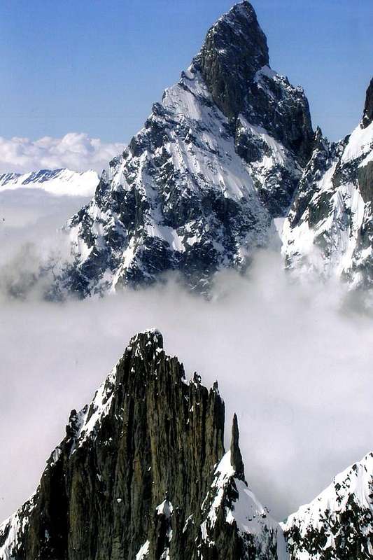
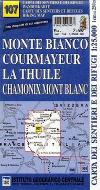
MONT BLANC / GRANDES JORASSES / AIGUILLE VERTE and 33 MOUNTAIN CHAINS of the AOSTA VALLEY & SURROUNDINGS
AOSTA VALLEY 360° from West to East and from East to West in TOPOGRAPHIC clockwise system and order from
Seigne Pass towards Ferret Pass (PARTS A+B+C+D+E+F+G).
FIRST PART (A):
A)- ITALIAN, FRENCH & SWISS MONT BLANC from Southwest (
Seigne Pass) to Northeast (Great Ferret Pass and Northern French & Swiss Appendages).
^^^^^^^
VENY and FERRET VALLEYS PARTIAL CIRCULAR PERIMETER (40°) Fractions, Hameaux, Villages and
indications-signals of departures to refuges, bivouacs, mountains.
VENY VALLEY (13°~) from Courmayeur/Entrèves
crossroads S.S. 26, by regional route:
This includes the Third Party Graian of Northwest, paradoxically, the most Eastern
, and understanding of the Chain of Mont Blanc from the Col de la Seigne to Col de Ferret. In this work, we have also carried out a hail, as well as the mountains that form the border ridge between France and Italy, also on those between France and Switzerland, because Mother Nature but not men have traced these lines. In fact, the Group of Mont Blanc is unique even if it belongs to three different countries. So we have also included the mountains between the latter two Nations and their Appendices. However, with respect crossings or the hills, generally difficult and turned almost exclusively to Mountaineers, we took into consideration only those of the crest of the border between Italy and France. The crossing of the same requires a good experience of mountain and, often, technical skills that have nothing to envy to those for the climb to the nearby summit, and indeed it often happens that a part of the via facing these steps necessarily involve a route to the hill, or makes a part of this and then turn on a ridge or a wall. Less frequently the opposite, in fact it is far more rare that a hill was reached down from a peak, but it happened. As for the Summits they were divided into three major areas, in order Southwest to Northeast and finally to the North:
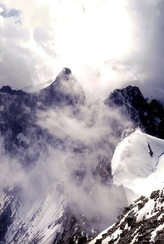
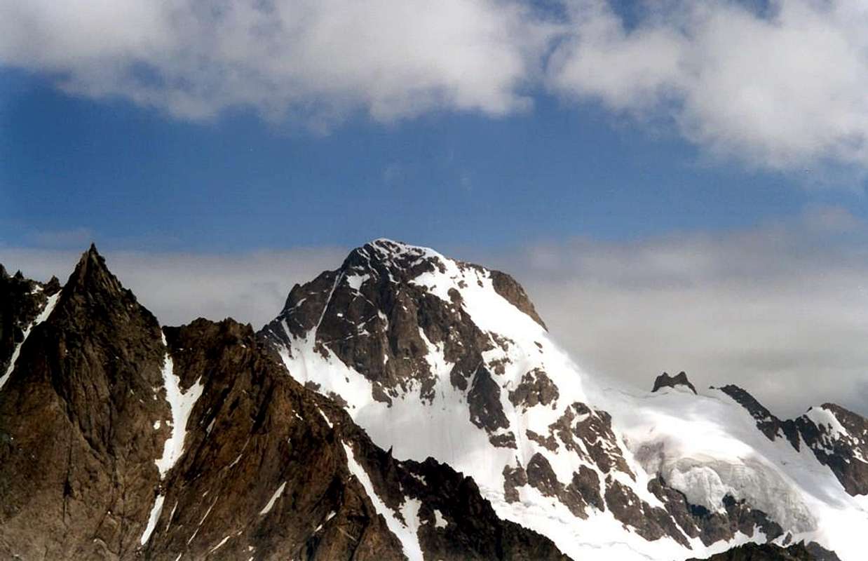
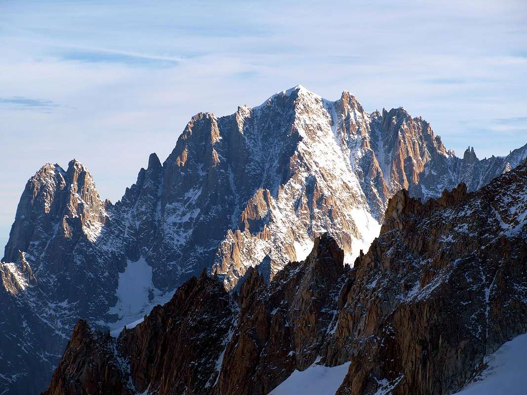
Mount Blanc, Great Jorasses and Aiguille Verte, the latter completely in French territory.
As for the
Approaches and was made a dash towards the base Shelters and Bivouacs of both the two Valleys Vény and Ferret, pointing out that for all the climbs in the
Mont Blanc Mountain Chain you go, fortunately, always through one or another. This does not mean the right to make the climbs during the day as often happens to the area of the Glacier of Géant, where a large cable car departing from
la Palud by Courmayeur (
1370m; Parking) leads, after a first section that passes through the Pavillon of Mount Fréty (
2174m; Refuge) up to ten Torino Refuge, Old and New
(3350 meters and 3371 meters), at Point Helbronner. A gondola lift goes away, high on the
"Mer de Glace", reaching the ummit of the Aiguille of Midi
(3800m, 3843m), entirely in French territory. Another cable car makes the final stretch with a spectacular descent to the Chamonix Valley reaching first Plan of the Aiguille (
2242m; Hotellerie
2234m) and finally the Village of Le Pra Conduit
(about 1000 meters), whence in a short in Chamonix or, since 1921,
Chamonix-Mont Blanc (1037 m). In the other vallons or basins glacial ascents, in just one day from the valley, require knowledge of the area, good time with its visibility and also logically high degree of training.
It also has hinted at a number of routes that have become
Classics uphill, without claiming to have all of them mentioned, more typical of a Mountain Guide Book.
![]() Questa Terza Parte comprende le Alpi Graie di Nordovest, paradossalmente le più ad Oriente
, e comprensive della Catena del Monte Bianco dal Col de la Seigne al Col de Ferret. In questo lavoro, inoltre, abbiamo effettuato una sventagliata, oltre che sulle montagne che costituiscono la cresta di frontiera tra Italia e Francia, anche su quelle tra Francia e Svizzera, poiché non Madre Natura bensì gli uomini han tracciato queste linee. In realtà il Gruppo del Monte Bianco é unico anche s'appartiene a tre Nazioni diverse. Quindi abbiamo inserito anche le montagne tra queste due ultime Nazioni e le loro Appendici. Per quanto concerne invece i valichi od i colli, in genere abrupti e rivolti quasi esclusivamente ad Alpinisti, abbiamo preso in considerazione esclusivamente quelli della cresta di confine tra Italia e Francia. La traversata dei medesimi richiede una buona esperienza di montagna e spesso, capacità tecniche che nulla hanno da invidiare a quelle rivolte alla salita alle viciniore Sommità; anzi spesso succede che una parte della via indirizzata a queste passi obbligatoriamente attraverso un itinerario verso il colle, oppure compia una parte di questo per poi deviare su d'una cresta od una parete. Meno frequente l'opposto, infatti risulta ben più raro che un colle sia stato raggiunto in discesa da una vetta, ma é successo. Per quanto concerne le Vette esse son state divise in tre grandi aree; in ordine da Sudovest a Nordest ed infine a Nord: Monte Bianco, Grandes Jorasses ed Aiguille Verte, questa ultima completamente in territorio francese.
Per quanto riguarda gli Avvicinamenti ne é stato effettuato un tratteggio di base verso i Rifugi ed i Bivacchi di entrambe le due Valli di Vény e di Ferret, facendo rilevare che per tutte le ascensioni nella Catena del Monte Bianco si passa, fortunatamente, sempre tramite o l'uno o l'altro. Ciò non esenta dalla facoltà d'effettuare le ascensioni in giornata come spesso succede per la zona del Glacier du Géant, ove una grande funivia con partenza da la Palud di Courmayeur (1370 m; Parcheggio) porta, dopo un primo troncone che passa per il Pavillon du Mont Fréty (2174 m; Rifugio) fino ai due Rifugi Torino, Vecchio e Nuovo (3350 metri circa e 3371 metri), presso Punta Helbronner. Una cabino via prosegue, alta sulla "Mer de Glace", raggiungendo la Vetta dell'Aiguille du Midi (3800 m; 3843 m), completamente in territorio francese. Un'altra funivia effettua il tratto terminale con una spettacolare discesa verso la Valle di Chamonix raggiungendo dapprima Plan de l'Aiguille (2242 m; Hotellerie 2234 m) ed infine il Villaggio di Le Pra Conduit (1000 metri circa), donde in breve a Chamonix o, dal 1921, Chamonix-Mont Blanc (1037 m). Negli altri valloni o bacini glaciali le ascensioni, effettuabili in giornata dal fondo valle, richiedono conoscenza del territorio, tempo buono con relativa visibilità ed inoltre logicamente ottimo grado di allenamento.
Inoltre s'é accennato ad una serie di Vie di salita ormai diventate Classiche, senza aver la pretesa di averle tutte citate, cosa più propria di una Guida di Alpinismo.
***
The Caravan of our PUPPIES is Infinite, like the Peaks of Mont Blanc,
by Camillo Roberto Ferronato
Questa Terza Parte comprende le Alpi Graie di Nordovest, paradossalmente le più ad Oriente
, e comprensive della Catena del Monte Bianco dal Col de la Seigne al Col de Ferret. In questo lavoro, inoltre, abbiamo effettuato una sventagliata, oltre che sulle montagne che costituiscono la cresta di frontiera tra Italia e Francia, anche su quelle tra Francia e Svizzera, poiché non Madre Natura bensì gli uomini han tracciato queste linee. In realtà il Gruppo del Monte Bianco é unico anche s'appartiene a tre Nazioni diverse. Quindi abbiamo inserito anche le montagne tra queste due ultime Nazioni e le loro Appendici. Per quanto concerne invece i valichi od i colli, in genere abrupti e rivolti quasi esclusivamente ad Alpinisti, abbiamo preso in considerazione esclusivamente quelli della cresta di confine tra Italia e Francia. La traversata dei medesimi richiede una buona esperienza di montagna e spesso, capacità tecniche che nulla hanno da invidiare a quelle rivolte alla salita alle viciniore Sommità; anzi spesso succede che una parte della via indirizzata a queste passi obbligatoriamente attraverso un itinerario verso il colle, oppure compia una parte di questo per poi deviare su d'una cresta od una parete. Meno frequente l'opposto, infatti risulta ben più raro che un colle sia stato raggiunto in discesa da una vetta, ma é successo. Per quanto concerne le Vette esse son state divise in tre grandi aree; in ordine da Sudovest a Nordest ed infine a Nord: Monte Bianco, Grandes Jorasses ed Aiguille Verte, questa ultima completamente in territorio francese.
Per quanto riguarda gli Avvicinamenti ne é stato effettuato un tratteggio di base verso i Rifugi ed i Bivacchi di entrambe le due Valli di Vény e di Ferret, facendo rilevare che per tutte le ascensioni nella Catena del Monte Bianco si passa, fortunatamente, sempre tramite o l'uno o l'altro. Ciò non esenta dalla facoltà d'effettuare le ascensioni in giornata come spesso succede per la zona del Glacier du Géant, ove una grande funivia con partenza da la Palud di Courmayeur (1370 m; Parcheggio) porta, dopo un primo troncone che passa per il Pavillon du Mont Fréty (2174 m; Rifugio) fino ai due Rifugi Torino, Vecchio e Nuovo (3350 metri circa e 3371 metri), presso Punta Helbronner. Una cabino via prosegue, alta sulla "Mer de Glace", raggiungendo la Vetta dell'Aiguille du Midi (3800 m; 3843 m), completamente in territorio francese. Un'altra funivia effettua il tratto terminale con una spettacolare discesa verso la Valle di Chamonix raggiungendo dapprima Plan de l'Aiguille (2242 m; Hotellerie 2234 m) ed infine il Villaggio di Le Pra Conduit (1000 metri circa), donde in breve a Chamonix o, dal 1921, Chamonix-Mont Blanc (1037 m). Negli altri valloni o bacini glaciali le ascensioni, effettuabili in giornata dal fondo valle, richiedono conoscenza del territorio, tempo buono con relativa visibilità ed inoltre logicamente ottimo grado di allenamento.
Inoltre s'é accennato ad una serie di Vie di salita ormai diventate Classiche, senza aver la pretesa di averle tutte citate, cosa più propria di una Guida di Alpinismo.
***
The Caravan of our PUPPIES is Infinite, like the Peaks of Mont Blanc,
by Camillo Roberto Ferronato
![]() ^^^^^^^
LEGENDA
^^^^^^^
LEGENDA
In
red: paths, routes, cable railway, chair lift & main roads;
in
green: Summits, Spurs, Buttress, Spires;
in
blue: Glaciers, Lochs, Ponds, Streams, Torrents, Brooks & Fountains;
in
purple: Passes, Saddles, Hills, Brèches, Carvings & Collars;
in
brown: Historical Remarks, Sanctuaries, Hermitages, Oratories, Castles, Churchs, Chapels, Crosses, Cairns, Tumulus, Mines, Historic Bridges or Roads, Campings, meaning of place names & various informations.
Getting There
By car:
- From TORINO, MILANO, etc: Motorway A5. Exit at MORGEX.
- From SWITZERLAND: through the Great Saint Bernard Tunnel or the namesake Pass, closed since half November until half May.
- From FRANCE: through the Mont Blanc Tunnel. From Little Saint Bernard Pass, closed since late Autumn until half Springtime, to La Thuile Valley, Pré Saint Didier, Courmayeur.
It is not necessary to take Motorway A5: you can drive on SS.26, in the direction of AOSTA.
By plane:
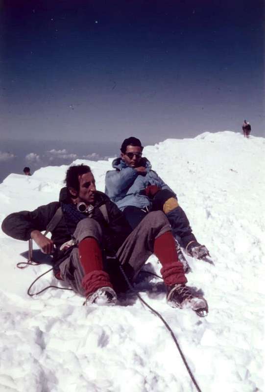
![]() MONT BLANC Old Summit 4810m, on JULY 20th, 1969
MONT BLANC Old Summit 4810m, on JULY 20th, 1969
![]()
From Courmayeur Town (Veny & Ferret Valleys) ROUTES > to MOUNT BLANC & from Italian Mountain Chain
We treat those pathways that are simply the beginning stage for an ascension to one of these peaks, they generally turn to the first part or after departure from the valley bottoms in Vény or in Ferret Valleys, both at the Tourist Center Courmayeur to the Refuges, bivouacs, Alps, Glaciers or natural shelters beginning at the base of the climbs themselves. Where there are well-marked trails and reported has been given an abbreviation for the same, otherwise the wording has been carried out of the path of simple numbered or not, and sometimes discontinuous traces of the path.
There were also lists some of the most famous climbs in the Mont Blanc mountain chain, conscious of not being able to list all the paths laid and existing job more suited to a mountaineering guide. It remains, however, a good indication to support those who want to know this great chain of mountains.
Trattiamo di quelle vie che son semplicemente la fase d'inizio per una ascensione ad una di queste cime; esse, in genere, si rivolgono alla prima parte ovvero dalla partenza dal fondo valle in Val Vény oppure in Val Ferret, entrambe presso il Centro Turistico di Courmayeur, verso i Rifugi, Bivacchi, Alpi, Ghiacciai o ripari naturali alla base dell'inizio delle ascensioni medesime. Ove esiston sentieri ben tracciati e segnalati ne é stata riportata la sigla indicante gli stessi; altrimenti é stata effettuata la dicitura di sentiero non numerato o di semplici, ed a volte discontinue, tracce di percorso.
Si son altresì elencate alcune delle più rinomate ascensioni nella Catena del Monte Bianco, consci di non aver potuto richiamare tutte le vie tracciate ed esistenti, lavoro più consono ad una guida d'alpinismo. Rimane, comunque, una indicazione valida a supporto di chi vuole conoscere questa grande catena di montagne.
In ogni caso bisogna tenere presente che nell'arco di tutto questo tratto di catena non esistono itinerari Escursionistici e tanto di meno Turistici; infatti gli unici due colli "abbordabili" sono quello di inizio, cioé il Col de la Seigne, e quello al termine della catena o Col Ferret. Anche per questi sono però necessarie condizioni di bel tempo e di chiara visibilità, soprattutto nel caso delle traversate da un versante all'altro. Si possono sfruttare i due Rifugi Elisabetta in Val Veny ed Elena in quella di Ferret; costituiscono un buon punto di appoggio per due vie lunghe, s'effettuate in maniera completa.
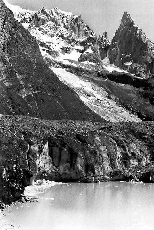
Notre Dame de la Guérison (+; votive Chapel); Plan Ponquet; Lassy Desot; across of the
Veny Valley Dora Stream Perthud, Péuterey (1507m;
la Sorgente Camping;
(no thohoroughfare signal) by easy trace
---> start to Brenva Glacier in Northeast and to
Noire Refuge-Borrelli/Pivano Bivouac (2316m) in North-northwest by path and Via Ferrata
(Iron Route or Equipped) ---> n° 19.
Ascents from left (West): Péuterey Monts Rouges, Pic Gamba, Aiguille Noire of Péuterey also Péteret South Ridge, South Wall and SE Arete or normal route, Mont Noir of Péuterey.
From
Péuterey Pastures continuation to Northwest by path
---> n° 7 to
Freney Pastures (little bridge to
Miage Chalets in Southeast), and by
---> n° 16 to
Miage Jardin,
Miage Glacier
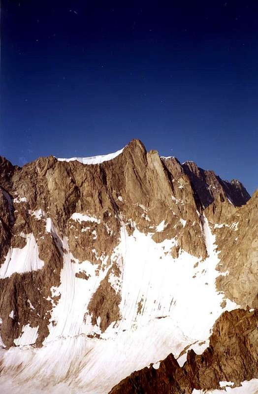
MIAGE LAKE near MIAGE GARDEN and offspring of the MIAGE GLACIER, on JULY 1974, by livioz
![]()
to and from left Durier (3365m~), Gonella (3072m), Quintino Sella (3368m) Refuges, near
Bionnassay, Dome, Mount Blanc Glaciers.
Ascents from left: Little Mont Blanc East-northeast Couloir, Trelatete Aiguilles E-NE Couloir, Tete Carrée East Face, Infracchissable Pass NE Couloir and Domes of Miage SE Ridge, Aiguille de Bionnassay East Edge, Dome of Gouter and
Mount Blanc East-northeast Arete or Italian normal route, Mount Blanc and Mount Blanc of Courmayeur SW Slopes, Crest of Brouillard (Amedeo, Brouillard, Baretti, Aiguilles Rouges Points) West Faces.
La Visaille path n° 16-->Refuge Franco Monzino (2561m) in Chatelet Area:
Brouillard, Freney Glaciers.
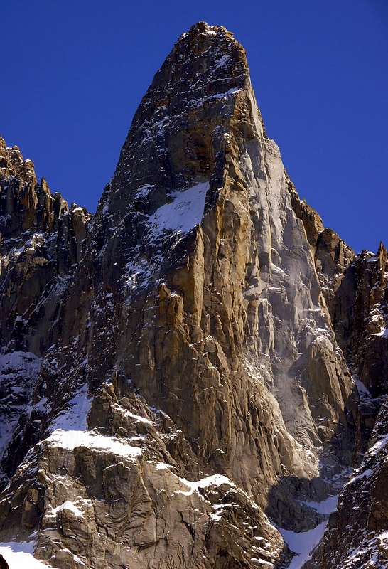
Ascents from left: Brouillard Crest and Pillars; Innominata Crest and Eccles, Innominata, Croux Points; Freney Pillars, Péuterey Crest, Aig. Blanche, Pic Gugliermina SW Face, Dames Anglaises, Noire W Wall (Ratti-Vitale and others) and Pic Gamba.
From Lassy Desot, by Regional route, Lassy Damon, Dzerotta Damon, du Meitin and Desot
(Higher, Middle, Lower; Aiguille Noire and Cuignon Campings)), Dzergnes, Plan Veny, Caserma, Gabba, Chalets du Miage (by bridge upon
Veny Doire Stream deviation by path
n° 16 to
Monzino Refuge and
Miage Glacier),
Visaille Cantina and Plan de Lognan (Cellar-Basement and Lognan Tableland; no transit signal and block in quota 1700m~);
---> start to Miage Jardin, by
n° 17; Combal Bar, near
Combal in West and
Miage Lakes to
Petit Mont Blanc/Gino Rainetto-Giovana Montagna Bivouac (3047m)
---> start by n° 14 and by path
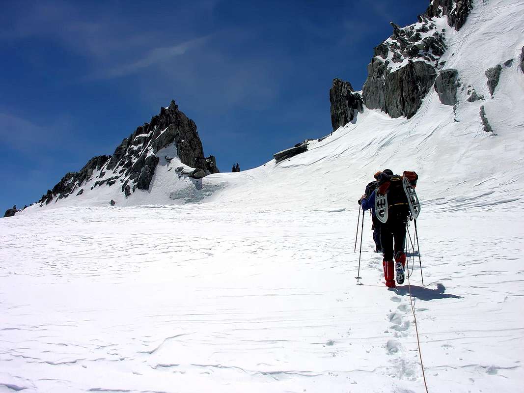
n° 12/13; Alta Via n° 2 and TMB (Higerh Route and Mount Blanc Tour) ---> start to Lex Blanches Barracks and
Elisabetta Soldini Refuge (2197m), below the Calcaires Pyramids and at
Seigne Pass (2514m), near
Doire Stream Sources. From refuge to Northwest by
n° 13 Echellettes/Hess Bivouac (2958m).
Ascents from left (West): Seigne Pass, great crossing to Petite and Aiguille des Glaciers by South Arete, Aig. des Glaciers from Echellettes-Hess Bivouacs, Aig. de la Lex Blanche by
Lex Blanche Glacier; from Little Mont Blanc/GinoRainetto-Giovane Montagna Bivouac: Aiguilles des Trélatete East-southeast Ridge and Traveerse, Aig. de l'Aigle South-southeast Edge by South-southeast Crest and cross of Little Mount Blanc, Aig. de Combal.
FERRET VALLEY (27°~) from
Courmayeur-Entrèves/La Palud Mount Blanc or of Glaciers Cables Railways departure Station):
From
la Palud, third parking, Velà Chapy East (1470m~)
start by path---> n° 20 to
Pavillon Refuge (2174m), near Mount Fréty; deviation to West in crossroads quota 2550m and start by
path---> n° 20b to
Thoules, Entrèves Glaciers, approach to Entrèves Tower, Père Eternel and Aiguille of Brenva East Face
. To North Old and New Torino Refuges (3350m~, 3371m), near Helbronner Point at Giant Pass.
Ascents: Entrèves Tower and Aig., Brenva Pic, Père Eternel and Aig. de la Brenva East Face; Valley Blanche Traverse, Tour Ronde Group routes; approachs Brenva routes, Great Angular Pillar North (Bonatti-Zappelli, Dufour-Fréhel, Baumont-Becker and others), NE (Cecchinel-Nominé and other) and East Walls (Bonatti-Gobbi, Chrobak-Laukajtys-Mroz and various), Péuterey Crest, Freney Pillars (Gervasutti, Central, Derobé, various routes); Mount Maudit EE and NE Crests (Kuffner-Burgener-Furrer Route), SE Face (Binel-Crétier-Chabod Red Pillar; Bonatti-Gallieni-Oggioni and other routes), Couloirs and Spurs face NE between Androsace Point and M.B. de Tacul; Tacul and satellites (Grand (Enrico August with mountain guides Adolphe Rey-Henri Rey-Louis Lanier, '24) and Petit Capuchin (Luigi De Riseis with mountain guides Adolphe Rey-Henri Rey, 1914), Pic Adolphe Rey (Mrs Ninì Pietrasanta-Gabriele Boccalatte-Renato Chabod-Giusto Gervasutti, '35), Tacul Trident (Mrs Guillemin-T. de Lépiney-L. Nelter-R. Picard, '31),
TACUL TRIDENT (3693m) Lépiney & Company Route on May 15th, 1969
![]()
Les Aiguillettes NW Summit (Adolfo Hess with mountain guides Laurent Croux-Félix Ollier, 1898), Les Aiguillettes SE Summit (Adolfo Hess-Oscar Leitz with mountain guides Louis Mussaillon-Ferdinand Melica, 1902), Tacul Clocher (T. de Lépiney-R. Picard-P. Tezenas du Montul, '26), Le Petit Clocher (Yves Bettemburg-Jean Celeyron-Francois Celeyron with mountain guide Jean Paul Charlet, '48), Tacul Chandelle (Walter Bonatti-Roberto Gallieni, '60), Tacul's Pyramid (Renato Chabod-Massimo Mila, '34), Roi du Siam (L. Baume-G. Baume with mountain guide Arthur Ottoz, '52), Le Chat (mountain guides Laurent Grivel-Arthur Ottoz, '40), ;
MOUNT BLANC of TACUL, NEW DAWN in final part through N-NW Face towards the West Summit (4248m), on AUGUST HOLIDAY, 1973
![]()
M.B. de Tacul N-NW Face, normal route, and Crossing to M. Blanc; Aig. du Midi South Face (Rébuffat route and other); Cosmiques Arete and traverse Midi-Plan; Giant's Jag, Rochefort Arete and traverse to Grandes Jorasses; Aiguilles Marbrées.
From
la Palud to Northeast by regional route
Mayen, Montitaz, Planpincieux (1593m;
Grandes Jorasses Camping and deviation to Rochefort Village); by path
---> start n° 21 to
Jorasses or Boccalatte-Piolti Refuge (2804m).
Ascents: of Rochefort Crest South Slopes, Great Jorasses Pass
Canzio Bivouac (3818m), Great Jorasses normal route, Great Jorasses Tower (routes various).
From
Planpincieux Village, Pont, Tronchey (Tronchey Camping and Golf Club),
Prà Sec d'en Bas, du Milieu and d'en Haut, Lavachey, Frébouge or Fréboudze (1654m). Departures by paths in Northwest to
Jachia Bivouac and in North to
Gervasutti Bivouac (2835m).
Ascents: Aig. de l'Eveque, Aig. and Tronchey Ridge, Walker Point East Face (Gervasutti-Gagliardone and other), Hirondelles Crest, Hirondelles and Fréboudze Point, Petites Jorasses NE Ridge or normal route and East Face (Bonatti-Mazeaud and other), Aig. de Leschaux South Face or normal route, Mont Greuvetta W Arete normal route.
From
Lavachey, Ferrachet, Greuvetta, Arnouva (1709m; parking and signal no thoroughfare) and by paths
---> start n° 22 to North-northwest
Comino Bivouac (2414m) and
n°23 to North
Triolet or Dalmazzi Refuge (2584m).
Cesare DALMAZZI REFUGE also TRIOLET (2584m), on JULY 29th, 2001
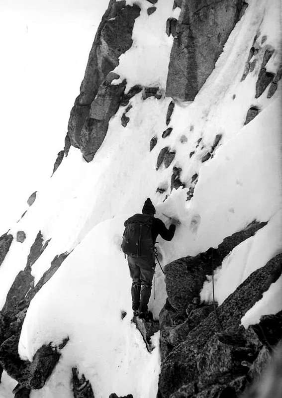
Ascents: Mont Rouge de Greuvetta and Mont Greuvetta, Aig. de Leschaux North Face and North Edge, Aig. de l'Eboulement, Aig. de Talèfre East Ridge or normal route, Aig. de Savoie SE Edge or Paul Preuss Route
AIGUILLE of SAVOIE (3604m), SE Edge also Pauli Preuss Route, on JULY 29th, 2001
and descent to TRIOLET GLACIER
, Papillons and Isabella Points, Aig. de Triolet SW Crest or normal route and South Face, Monts Rouges de Triolet.
From
Arnouva by route
---> start n° 25 or ---> start higher path
n° 25 TMB to Tsa de Jean and Tsa de Jean Damon also Pré de Bar Higher Alp towards
Elena Refuge, near Pré de Bar Alp (2062m); by path
n° 24 to
Little Ferret Pass and
Dolent Refuge and Fiorio Bivouac (2720/30m~ and 2780m).
Ascents: Mont Rouges de Triolet, Aig. de Triolet East Face, Domino Point, Pré de Bar Points, Mount Dolent South Face or Normal route, Mont Grapillon and Little, P. Allobrogia, great crossing Mount Dolent by ES Arete or Grapillon Ridge.
From
Elena Refuge by path
---> start n° 26 and TMB to Nortthwest towards
Great Ferret Pass and Swiss Ferret Valley.
*^*^*^*
MOREOVER in SECOND (B), THIRD (C), FOURTH (D), FIFTH (E), SIXTH (F), SEVENTH (G) PARTS:
From West to East and from East to West in
topographic clockwise system and order.
(PARTS B+C+D+E+F+G)- AOSTA VALLEY CIRCULAR (320°~) PERIMETER OUTSIDE AREA: from Great FERRET Pass to of the SEIGNE Pass.
INSIDE RANGES:
From COURMAYEUR-MONT BLANC Tourist little Town to Pont Saint Martin in Aosta Valley and Carema/Settimo Vittone/Donato/Andrate little Towns PIEDMONT and AOSTA VALLEY NORTHERN HALFCIRCULAR PERIMETER:
B+C)- Dora Baltea Stream Left Hydrographic Watershead: from Courmayeur Tourist, Morgex, La Salle, Saint Pierre, Sarre little Towns (West) to AOSTA Town (East) and from City to Quart,Nus, Chambave, Chatillon, Saint Vincent, Montjovet, Verrès, Arnad, Donnas, Pont Saint Martin little Towns (Southeast) and between Biella/Turin Provinces in PIEDMONT.
D)- Dora Baltea Stream Right Hydrographic Watershead: from Pont Saint Martin, Hone, Champdepraz, Pontey, Fénis, Saint Marcel, Brissogne, Pollein, Charvensod, Gressan, Jovencan (East) to Aymavilles little Town (West) and to Cogne Tourist little Town (Southwest) and "appendages" from East to West of the: Valsavarenche Valley, Rhemes Valley, Valgrisenche Valley, Derby/Lazoney little Valley, Arpy Conca (area) and La Thuile Valley.
A1)- *** ALL EXTERNAL PASS, saddles, brèches, collars, "carvings" & ROUTES from AOSTA VALLEY to FRANCE and SWITZERLAND
A1)- *** ALL EXTERNAL
PASS, saddles, brèches, "carvings" and
ROUTES from
AOSTA VALLEY to
FRANCE and
SWITZERLAND.
![]()
In this section we will do an overview of all the mountain passes between France and Aosta Valley belonging to the chain of Mont Blanc and many of these have been crossed, or simply used for the ascent of at least one of the two slopes. Others are entirely theoretical and are aimed at a new and future generation of climbers who, exhausted the search for peaks, will look to the hills, even with hard and difficult climbs that have nothing to do with the traditional passage of such a valley between and the other. In this "modus operandi", rather than a technical discourse of the different routes of ascent and descent, we turned to the
Historical Part of ascents and penetrations so far carried out, deferring to a next job, more specifically, the relationship of existing roads and , until now, draw.
In any case we must keep in mind that over all this part of the chain
there are Hiking trails and much less Tourists in fact the only two hills "affordable" are to start, ie the Col de la Seigne, and the end chain or Ferret Hill. Even for these, however, are necessary conditions of good weather and clear visibility, especially in the case of crossings from one side to another slope. You can take advantage of the two Refuges Elisabetta Soldini in Val Veny and Ferret to Elena, are good val base for two-way long, if made in full.
Also remember to note that these passages from one side to the other are not just walking, but they are subject, given the altitude, a number of risks and unpredictability do not evaluate under absolutely. Who does it make a serious and unforgivable mistake and is exposed, rather an obvious consequences related. From the bottom of our small experience we can say: check the sports, the equipment and food resources in case. It seems superfluous to say this, but remember that it is better to have a clothing in more than one less, while food resources, in our view, must cover one more day of the estimate and those of the two liquids. Do not think that the current trivially possibility of communication can solve any problem: there is always time allows rescuers to take immediate action. We noticed, lately but surely this has always been the case, that this factor does not spare anyone.
Even the most talented ...
![]() In questa sezione effettueremo un excursus su tutti i valichi alpini tra Valle di Aosta e Francia appartenenti alla Catena del Monte Bianco; molti tra questi sono stati attraversati o, semplicemente, utilizzati per la salita di almeno uno tra i due versanti. Altri son del tutto teoretici e rivolti ad una nuova e futura generazione d'alpinisti la quale, esaurita la ricerca delle vette, si rivolgerà ai colli, anche con ascensioni dure e difficili che null'hanno da spartire con il passaggio tradizionale dei medesimi tra una valle e l'altra. In questo "modus operandi", più che ad un discorso tecnico delle varie vie di salita e discesa, ci siam rivolti alla Parte Storica delle ascensioni e degli attraversamenti fino ad ora effettuati, rinviando ad un prossimo lavoro, maggiormente specifico, le relazioni delle vie esistenti e, fino ad ora, tracciate.
In ogni caso devesi tener presente che in tutto quest'arco di catena non esistono itinerari Escursionistici e quanto meno Turistici, in quanto gli unici due "abbordabili" sono quelli all'inizio o Col de la Seigne, e quello al termine della medesima ovvero il Col Ferret. In ogni caso devon sempre, vista la lunghezza dei percorsi se affrontati integralmente dall'uno all'altro versante, sussistere condizioni di bel tempo nonché di buona visibilità durante il percorso. Epper ciò ci si può affidare al Rifugio Elisabetta Soldini in Val Vény ed al Rifugio Elena in quella di Ferret; entrambi costituiscono un ottimo punto di appoggio.
Inoltre v'é da osservare che questi passaggi da un versante all'altro non costituiscono semplici passeggiate, bensì sono assoggettati, vista l'altitudine, a tutta una serie di rischi ed imprevidibilità da non sottovalutare assolutamente. Chi lo fa commette un grave ed imperdonabile errore e s'espone, piuttosto in maniera evidente, a conseguenze relative. Dal basso della nostra piccola esperienza possiamo affermare: controllare l'attrezzatura, l'equipaggiamento e le risorse alimentari per ogni evenienza. Sembra superfluo questo dire ma memento é meglio avere un vestiario in più che un in meno, mentre le risorse alimentari, a nostro avviso, debbon coprire un giorno in più del preventivo e quelle dei liquidi due. Non pensare banalmente che le attuali possibilità di comunicazione risolvano ogni problema: non sempre il tempo permette ai soccorritori di intervenire tempestivamente. Abbiamo notato, ultimamente ma forse così è sempre avvenuto, che questo fattore non risparmia nessuno. Neppure i più bravi ...
From Col de la Seigne to Mount Blanc
In questa sezione effettueremo un excursus su tutti i valichi alpini tra Valle di Aosta e Francia appartenenti alla Catena del Monte Bianco; molti tra questi sono stati attraversati o, semplicemente, utilizzati per la salita di almeno uno tra i due versanti. Altri son del tutto teoretici e rivolti ad una nuova e futura generazione d'alpinisti la quale, esaurita la ricerca delle vette, si rivolgerà ai colli, anche con ascensioni dure e difficili che null'hanno da spartire con il passaggio tradizionale dei medesimi tra una valle e l'altra. In questo "modus operandi", più che ad un discorso tecnico delle varie vie di salita e discesa, ci siam rivolti alla Parte Storica delle ascensioni e degli attraversamenti fino ad ora effettuati, rinviando ad un prossimo lavoro, maggiormente specifico, le relazioni delle vie esistenti e, fino ad ora, tracciate.
In ogni caso devesi tener presente che in tutto quest'arco di catena non esistono itinerari Escursionistici e quanto meno Turistici, in quanto gli unici due "abbordabili" sono quelli all'inizio o Col de la Seigne, e quello al termine della medesima ovvero il Col Ferret. In ogni caso devon sempre, vista la lunghezza dei percorsi se affrontati integralmente dall'uno all'altro versante, sussistere condizioni di bel tempo nonché di buona visibilità durante il percorso. Epper ciò ci si può affidare al Rifugio Elisabetta Soldini in Val Vény ed al Rifugio Elena in quella di Ferret; entrambi costituiscono un ottimo punto di appoggio.
Inoltre v'é da osservare che questi passaggi da un versante all'altro non costituiscono semplici passeggiate, bensì sono assoggettati, vista l'altitudine, a tutta una serie di rischi ed imprevidibilità da non sottovalutare assolutamente. Chi lo fa commette un grave ed imperdonabile errore e s'espone, piuttosto in maniera evidente, a conseguenze relative. Dal basso della nostra piccola esperienza possiamo affermare: controllare l'attrezzatura, l'equipaggiamento e le risorse alimentari per ogni evenienza. Sembra superfluo questo dire ma memento é meglio avere un vestiario in più che un in meno, mentre le risorse alimentari, a nostro avviso, debbon coprire un giorno in più del preventivo e quelle dei liquidi due. Non pensare banalmente che le attuali possibilità di comunicazione risolvano ogni problema: non sempre il tempo permette ai soccorritori di intervenire tempestivamente. Abbiamo notato, ultimamente ma forse così è sempre avvenuto, che questo fattore non risparmia nessuno. Neppure i più bravi ...
From Col de la Seigne to Mount Blanc
1)-:
Collet de la Seigne (2694m), between Quota
2956m of Chavannes and Seigne Hill; unknown.
2)-: Col de la Seigne (2514m) betw. the Cross 205 meters and Montagnes des Glaciers; ab immemorabilis.
3)-: Petite Aiguille des Glaciers Saddles (3210m, 3331m) betw. the Montagnes des Glaciers and Little Aiguille des Glaciers; unknown or more probably a Mountain Guide of Horace Bénedicy De Saussure from Seigne Hill?, in 1778.
4)-: Scie Hill (3615m) betw. Aiguille des Glaciers and Aiguille de la Lex Blanche ; Maria Mazzucchi, Riccardo Cajrati Crivelli, G Mazzucchi with Courmayeurs Mountain Guides Laurent and Joseph Croux, César Ollier and Alexis Brocherel during the first ascent through Western Slope of hill and North Crest of Aiguille des Glaciers
(3817m), July 25th, 1901.
5)-: La Lex Blanche Pass (3502m) betw. Aiguille de la Lex Blanche and Trelatete Pass; V. Attinger and L. Kurz with Chamonix Mountain Guides Jean Baptiste Croz and Joseph Simond said "Louis" by North Crest, July 25th, 1889.
6)-: Trelatete Pass (3502m) betw. La Lex Blanche Pass and Quota 3660 metres on South-southwest Crest of Trelatete Central Summit; C.E. and G.S. Mathews with Chamonix Mountain Guides Michel Balmat and Jean Carrier from Glacier de la Lex Blanche also allée Blanche and Southeast Slope, August 23th, 1864.
7)-: Tete Carrée Brèche (3672m) betw. quota 3750 meters on North Crest of Trelatete Northern Summit and quota (3694 meters on South-southwest Crest of Tete Carrée; Martino Baretti with Courmayeur Mountain Guides Seraphin Henry, Jean Joseph Maquignaz and Auguste Sibille in crossing from Infracchissable Pass in first ascent of Tete Carrée, July 15th, 1880.
8)-: Infrachissable Pass (3344m) betw. Tete Carrée and Domes de Miage; James Eccles with Chamonix Mountain Guides Michel-Clement Payot and Marc Bellin during the first traverse from Miage Glacier and right side of the Northeast great Couloi, Summer 1870.
9)-: Miage Pass (3356m) betw. Domes de Miage and Aiguille of Bionnassay; probably crossed at the end of '700 by inhabitants of Courmayeur but surely by Chamonix Mountain Guide Frédéric Mollard & Companions, Summer 1849.
10)-: Bionnassay Pass (3892m) betw. Aiguille de Bionnassay and Dome of Gouter; A. Adams Reilly and John Birkbeck with Chamonix Mountain Guides Michel Croz, Michel-Clément Payot and Marc Tairraz from Miage Pass, traverse on slope of Aiguille de Bionnassay
(4052m), and before descent after ascent from Bionnassay Glacier, August 05th, 1864. The first and unique traverse from Bionnassay Glacier and Northern Face by R.W. Lloyd with Swiss Mountain Guides Joseph and Adolf Pollinger, August 14th, 1919.
11)-: Dome Pass (4240m) betw. Dome of Gouter and the Great Bosse on Northwest Ridge of Mount Blanc; Chamonix Mountain Guide Jean Marie Couttet with François Cuidet from Aiguille de Gouter
(3863m), September 17th, 1784.
From Mount Blanc to Col du Géant
12)-:
Col de la Brenva (4303m), betw. Mount Blanc and Mount Maudit; Christian Fellows and William Haves with Chamonix Mountain Guides Joseph-Marie Couttet, Mathieu Balmat, Simon Dévouassoud, David Folliguet, Pierre Marie Couttet, Michel Balmat, Pierre Joseph Payot, Michel Favret and Pierre Joseph Simond during the first ascent on Mount Blanc
(4818m) through the "Corridor", July 25th, 1827. First traverse by G.S. Mathews, A. W. Moore, F. and G. Walcker with Swiss Mountain Guides Jakob and Melchior Anderegg through Brenva Eperon in ascent and with the "Corridor", July 15th, 1865.
13)-: Fourche Brèche (3684m) betw. Point of Androsace and Northwest Jag of Fourche de la Brenva; M. von Kuffner with Swiss Mountain Guides Alexander Burgener, Josef Furrer and a Mountain Carrier from Northern Face?, July 03th, 1887. First traverse by V.J.E. Ryan with Swiss Mountain Guides Franz and Josef Lochmatter, July 10th, 1906.
14)-: Calotte de la Brenva Carving (3670m) betw. Southeast Tooth of Fourche de la Brenva and Calotte de la Brenva ; first crossing T. Graham Brown with Swiss Mountain Guides Alexander Graven and Josef Knubel from Cirque Maudit to Brenva Glacier, July 27th, 1931.
15)-: Trident Carving (3679m) betw. Calotte de la Brenva and Trident de la Brenva; Agostino Ferrari and Flavio Santi with Courmayeur Mountain Guides Julien Proment and Joseph Brocherel through Northern Slope and traverse to Tour Ronde
(3798m)Western Pass and descent on Brenva Glacier, September 08th, 1901. First crossing by W. Amstutz and P. Von Schumacher in ascent through North Face of Brenva "Calotte" and descent on South Slope, July 25th, 1927.
16)-: Tour Ronde Western Pass (3658m) betw. le Trident de la Brenva and Tour Ronde Eastern Pass; Agostino Ferrari and Flavio Santi with Courmayeur Mountain Guides Julien Proment and Joseph Brocherel arriving from Trident Carving and descending on Brenva Glacier, September 08th, 1901. Never crossed?
17)-: Tour Ronde Eastern Pass (3630m) betw. Tour Ronde Western Pass and West-southwest Crest of Tour Ronde; A. Millot with wife Johann Jaun with Chamonix Mountain Guides Henri Devouassoud and Michel Balmat from Glaciers of Géant to Brenva, August 02th, 1873.
18)-: Freshfield little Saddle (about 3600m) betw. Tour Ronde Southeast Crest and Pic de la Brenva; J. H. Backouse, T.H. Carson D.W. Freshfield, C.C. Tucker with Chamonix Mountai Guides Daniel Balleys and Michel Payot by Tour Ronde Southeast Crest and descent to Glacier of Géant through the little saddle, July 22th, 1867. In ascent with same route E. Eberty, W. Martin and P. Rreuschel, August 05th, 1908.
19)-: Entrèves Carving (3517m) betw. the junction Southeast Crest of Tour Ronde with Pic de la Brenva and Aiguille of Entrèves; James Eccles with Chamonix Mountain Guides Michel Clement Payot and Marc Belin through crossing fro Northwest to Southeast on Entrèves little Glacier, August 04th, 1870.
20)-: Thoules Western Carving (3488m) betw. Aiguille of Entrèves and Aiguille of Thoules Adolfo Hess and Flavio Santi with Courmayeur Mountain Guide Julien Proment returning from Aiguille of Entrèves
(3604m) and descent to Géant Glacier by North Face, August 31th, 1897.
21)-: Thoules Eastern Carving (3411m) betw. From iguille of Thoules and Grand Flambeau; James Eccles with Chamonix Mountain Guides Michel Clement and Alphonse Payot with traverse from North to South on Thoules Glacier, Summer 1870.
22)-: Col de Saussure (3428m), betw. Grand Flambeau and Helbronner Point; Gerald Leinweber and Marcel Kurz from Thoules Glacier and through South-southwestern Slope, July 19th, 1936. First repetition by Ercole Martina, lone, July 17th, 1959. Never crossed?
23)-: Col du Géant (3365m), betw. Helbronner Point and Aiguille Marbrées; from the Legend by the Courmayeur inabitants since XVII° Century. Probably Philibert-Amedée Arnod with three Courmayeur Hunters. Surely the first of Courmayeur Mountain Guide Jean Laurent Jordaney said "Patience" in different times and for reasons of hunting and in Summer 1786 with T. Ford Hill with Courmayeur departure. The first time from Chamonix through "Mer de Glace" by the "Chamouniards" Mountain Guides Jean Michel Cachat and Alexis Tournier and descent to Courmayeur in first traverse, June 27th, 1787.
***
From Col du Géant to Great Jorasses
24)-:
Rochefort Saddle (3387m), betw. Dent du Géant and Aiguille de Rochefort; James Eccles with Chamonix Mountain Guides Michel and A. Payot from Northwest or Oriental ramification of Géant Glacier to South on small glacier in altitude
2986 metres, between Aiguilles Marbrées
(3535m) and Géant Jag
(4014m),July 10th, 1877.
25)-: Rochefort Carving (3933m) betw. Dent of Géant and Aiguille of Rochefort; Ettore Allegra with Chamonix Mountain Guides M.C. and Alphonse Payot in crossing from Géant Hill and through Western Ridge Aiguille of Rochefort
(4001m), August 14th, 1873. Never crossed.
26)-: Grandes Jorasses Pass (3818m) betw. Calotte of Rochefort and Margherita Point of the Great Jorasses; A. Milman, F. Taylor, A.W. Wills with Chamonix Mountain Guides Michel and Frederic Payot, Claude Gurlie and Edouard Cupelin from Mount Mallet Glacier and by North Face, September 06th, 1864. First traverse by Thomas Middlemore with Mountain Guides Johann Jaun and Joseph-Marie Rey from North to South on Planpinceux Glacier and Ferret Valley. In opposite E. Mackenzie with Courmayeur Mountain Guides Julien Proment and Louis Bertholier through difficult descent by South Slope on Eastern rocky Spur of great Couloir, September 03th, 1894.
From Great Jorasses to Great Ferret Hill
27)-:
Hirondelles Pass (3485m), betw. Walker Point and Petite Jorasses; T.S. Kennedy, J.A.G. Marshall and Leslie Stephen with Swiss Mountain Guides Johann Fischer and Ulrich Almer from Leschaux Glacier and through the Northern rocky Ribbing and descent to Southeast on Frébouge also Freboudze Glacier to Lavachey in Ferret Valley, July 14th, 1873. G. Leppé and Henri Devouassoud through Northwest narrow Couloir and descent by the same route.
28)-: Petite Jorasses Pass (3520m), betw. Little Jorasses and Aiguille de l'Eboulement; Angelo Abrate, Francesco Ravelli and Guido Alberto Rivetti from Fréboudze Glacier and Eastern Slope, July 28th, 1923. Never crossed.
29)-: Leschaux Carving (3433m), betw. Aiguille of Eboulement and Aiguille de Leschaux; Charles Taylor, J. B. Colgrove and Richard Pendlebury with Swiss Mountain Guides Gabriel and Josef Spechtenhauser from Triolet Glacier and East Wall with descent by Western Face to a secondary branch of Leschaux Glacier, July 23th, 1877.
30)-: Southern and Northern Double Eboulement Saddle (3434m, about 3440m) betw. Leschaux Carving and Aiguille of Eboulement; probably in old times by Crystals Hunters, more probably by the Count of Saint Joseph with Chamonix Mountain Guide François Dévouassoud through Southwestern Slope in Summer 1863. Surely E.A. Broome with Swiss Mountain Joseph Marie Biner and Chamonix Mountain Guide Auguste Cupelin and first crossing from a secondary ramification of Leschaux Glacier to Southwestern Triolet Glacier, August 04th, 1893.
31)-: Pierre Joseph round rocky Saddle (3508m) betw. Aiguille of Eboulement and Aiguille of Talèfre; A. Adams Reilly and Charles-Edward Mathews with Chamonix Mountain Guides Michel Balmat and Michel-A. Ducroz in traverse from Aiguille of Eboulement
(3601m) and descent on West Face to Pierre Joseph Glacier, July 07th, 1866. First crossing by F. Baker Gabb and wife with Swiss Mountain Guides Clemenz Zurbriggen dad & son from France to Italy?, August 29th, 1891.
32)-: Savoie Carving (3491m) betw. Aiguille of Talèfre and Aiguille of Savoie; Edouard Matthey, Marcel Kurz with Swiss Mountain Guide Joseph-Louis Joris from Triolet Glacier and Southeast Face, August 14th, 1908. First crossing by G. and W de Meyendorff and Jean Morin from Eastern Talèfre Glacier and through West Face with descent by Southeast Slope to third ramification of Triolet Glacier, August 08th, 1924.
33)-: Talèfre Carving (3544m) betw. Aiguille of Savoie and Papillons Point; Edward Whymper with Swiss Mountain Guides Christian Almer and Franz Biner from Eastern Talèfre Flacier and Western Face with descent through Eastern Slope to second branch from North of Triolet Glacier, July 03th, 1865.
34)-: Piolet Brèche (3572m) betw. Pointe of Papillons and Point Isabella; G. Gruber with Courmayeur Mountain Guide Emile Rey and Austrian Mountain Guide Johann von Bergen from the second ramification of Triolet Glacier and descent by West-northwest Face on Eastern Talèfre Glacier, July 06th, 1881.
35)-: Triolet Pass (3705m) betw. Isabella Point and Petites Aiguilles du Triolet; Joseph Mieulet and Antony-Adams Reilly; G.C. Hodgkinson and John Birkbeck with Victor Tairraz and others Chamonix Mountain Guides from Talèfre Glacier and glacial West Face, July 07th, 1863. First traverse ntony-Adams Reilly and Edward Whymper with Chamonix Mountain Guides Michel Croz, Henri Charlet and Michel Payot from Talèfre Glacier to first or Northern ramification of Triolet Glacier through Southeast Slope, July 08th, 1864.
36)-: Brèche du Triolet (3611m); betw. Aiguille of Triolet and Point 3656 metres; René Desmaison and Yves Pollet-Villard from Southeastern branch of Argentière Glacier and on North-northwest icy (55°/65°; 320 metres) Wall, June 19th, 1960. Not crossed and not yet repeated.
37)-: Brèche du Domino (3574m) betw. Quota 3656 meters and Domino Point; Emile Fontaine with Chamonix Mountain Guides Joseph Ravanel and Léon Tournier in descent from Domino Point through Southwest Ridge, June 23th, 1904. Not yet climb for any of its two sides (Western from Argentière Glacier and Southeast from that of Pré de Bar).
38)-: Dolent Carving (3485m) betw. Domino Point and Quota 3613 metres of Pointe Superieure de Pré de Bar; Edward Whymper with Chamonix Mountain Guide Michel Croz and Swiss Christian Almer and Franz Biner from Pré de Bar Glacier through South-southeast Slope with descent by North-nortwestern icy (averaging 55 °, height 300 meters, without crampons!) Wall on Argentière Glacier, June 26th, 1865. In opposite and through the orographic right side of gully in ascent and descent to Pré de Bar Glacier, W.E. Davidson and J.W. Hartley with Mountain Guides Johan Jaun and Laurent Lanier, September 02th, 1878.
39)-: Grapillon Western Saddle (around 3606/8m), betw. Mount Dolent and Mount Grapillon; A. Pelloux with Courmayeur Mountain Guide ouis Mussillon from Pré de Bar Glacier, Southern Slope and first traverse on Southeast Ridge to Mount Dolent, July 01th, 1892. Not crossed.
40)-: Grapillon Eastern (about 3345/50m), betw. Mount Grapillon and Pointe Gratien Volluz/Petit Grapillon; A. Pelloux with Courmayeur Mountain Guide Louis Mussillon from Pré de Bar Glacier and Southern Slope to Mount Grapillon/Mount Dolent, July 01th, 1892. Ettore Levi and Ugo Malvano to Little Grapillon from Pré de Bar Glacier, South and Southwest Slopes, August 29th, 1903. From Mount Dolent Glacier by North-northeast Wall of nearby Gratien Volluz Point
(about 3356/62 meters); Yvette Vaucher, Michel Vaucher and Michel Darbelley, August 7/8th, 1967.
41-: Point Allobrogia Carving (3140m) betw. Little Grapillon and Allobrogia Point; Arnold and René Covveron from Pré de Bar Glacier and Souh-southwestern Slope during the first ascent on Allobrogia Point, August 03th, 1898. Swiss Mountain Guide
Maurice Crettez through the rocky North-northeast Face of the nearby Point Allobrogia, during a hunting trip prior to 1935.
42)-: Petit Ferret Pass also called Grapillon Pass (2510m) betw. quota 2517 metres betw. on terminal part of Point Allobrogia Southern Ridge and small Chantonnet Top 2576 metres before the Tete Ferret; unknown or "ab immemorabilis".
43)-: Great Ferret Hill (2531m) betw. Tete de Ferret and Arete of Econduits at the beginning of Pennine Alps; attended and crossed from the Remotest Antiquity.
![]()
A2)- *** ALL SUMMITS of the BLANC KING ^^^/\^^^
A2/a/b/c)- *** ALL SUMMITS of the
MOUNT BLANC ^^^/\^^^ MOUNTAIN CHAIN from Southwest to North-northeast:
AIG. of GLACIERS/AIG. of TRELATETE/AIG. of BIONNASSAY/COURMAYEUR MOUNT BLANC/MOUNT BLANC/MOUNT MAUDIT/MOUNT BLANC of TACUL/SATELLITES/AIG. of MIDI/AIG.s of CHAMONIX/GREAT CHARMOZ; TOUR RONDE/DENT of GEANT/GREAT JORASSES/LESCHAUX-GREUVETTA/TALE'FRE/AIG. of SAVOIE; The COURTES/The DROITES/AIG. VERTE/The DRUS; AIG. of MOINE; AIG. of TRIOLET/MOUNT DOLENT/TOUR NOIRE/AIG. of ARGENTIERE/AIG. of CHARDONNET/AIG. of TOUR; AIG.s DOREES.
In this area lists
all of the branches belonging to the Group of Mont Blanc. The work was carried out in an organic way, and generally dealing with the development of the chains from Southwest to Northeast and from West to East not forget that the crest has a course from the Southwest to the Northeast in the stretch between Italy and France and to the North most between the latter and Switzerland. It lists all the existing Summit, even the smallest and least important. The work has been made more difficult by the development of lateral appendages or routes sections. It is tried to solve the problem, if not the most brilliant, at least in the more practical as possible. A subsequent division into three distinct areas, that of
Mont Blanc and the Grandes Jorasses and the Aiguille Verte, it clearly articulates what Edward Whymper believed the only three important elevations of the chain, considering all the other extras like a satellites of the Maximum Peak. The analysis performed by the famous English mountaineer actually corresponds to what is shown by the topographical point of view. Whymper, among other things, was the first climber of two of these three big mountains, although for the Jorasses reached that now bears his name, while the highest peak was the prerogative of the party by Horace Walker.
In questo settore vengon elencate tutte le ramificazioni appartenenti al Gruppo del Monte Bianco. Il lavoro é stato effettuato in modo organico e, generalmente, trattando lo sviluppo delle catene da Sudovest verso Nordest e da Ovest verso Est. Non dimentichiamo che la cresta spartiacque ha andamento da Sudovest verso Nordest nel tratto tra Italia e Francia e masggiormente a Settentrione tra quest'ultima e la Svizzera. Si son elencate tutte le Sommità esistenti, anche le più piccole e meno importanti. Il lavoro é stato reso maggiormente difficoltoso dallo sviluppo delle appendici laterali o dai tratti di collegamento. S'é cercato di risolvere il problema, se non nel modo più brillante, almeno in quello più pratico possibile. Una successiva suddivisione in tre aree ben distinte, quella del Monte Bianco e quelle di Grandes Jorasses ed Aiguille Verte, scandisce in modo netto quelle che Edward Whyper riteneva fossero le uniche tre elevazioni importanti della catena, reputando tutte l'altre a guisa di comparse o satalliti della Vetta Massima. L'analisi effettuata dal famoso alpinista inglese in realtà corrisponde a quanto vien evidenziato dal punto di vista topografico. Whymper, tra l'altro, fu il primo salitore di due tra queste tre grandi montagne, anche se per le Jorasses raggiunse quella ch'oggi porta il suo nome, mentre la cima più elevata fu appannaggio della comitiva di Horace Walker.
A2/a) AIG. of GLACIERS/AIG. of TRELATETE; AIG. of AIGLE/LITTLE MOUNT BLANC; AIG. of BIONNASSAY/COURMAYEUR MOUNT BLANC/AIG. BLANCHE of PEUTEREY/GUGLIELMINA PEAK/AIG. NOIRE of PEUTEREY; ECCLES PEAK/INNOMINATA POINT/AIG. J.J. CROUX; MOUNT BLANC/MOUNT MAUDIT; TOUR RONDE/AIG. of BRENVA and SURROUNDINGS; TACUL MOUNT BLANC and SATELLITES; AIG. of MIDI and AIGUILLES of CHAMONIX MOUNTAIN CHAIN:
AIGUILLE des GLACIERS, near the SUMMIT Remains of the British Bomber, fallen on 1945, on JULY 29th, 1979
A2/a) or 18 From de la Seigne Hill and surroundings to Mount Blanc through great North-northeast watershed. Inside:
Pyramides Calcaires Higher and Lower. Montagnes des Glaciers/Petite Aiguille des Gaciers (3817m)/
Aiguille des Glaciers/Aiguille de la Lex Blanche/Aiguilles de Trelatete: Northwest, Central, Southeast (3930m)
and East Summits/Aiguille de l'Aigle/Petit Mont Blanc/Aiguille de Combal/Mont Tseuc; Tete Carrée
TETE CARREE (3726m) & Ancient Silver Mine, on JULY 27th, 2010
/Domes de Miage/Quote 3834, 3833, 3622, 3814, 3810m/Aiguille de Bionnassay (4052m)/Aiguille de Tricot/Pointes de Tricot SE or Superior, Central, Northwestern or Inferior/Mont Vorassay.
Calotte des Aiguilles Grises/Tour des Aiguilles Grises/Quote 3676, 3599, 3419, 3138, 3245, 2910m/Chaux de Pesse Group.
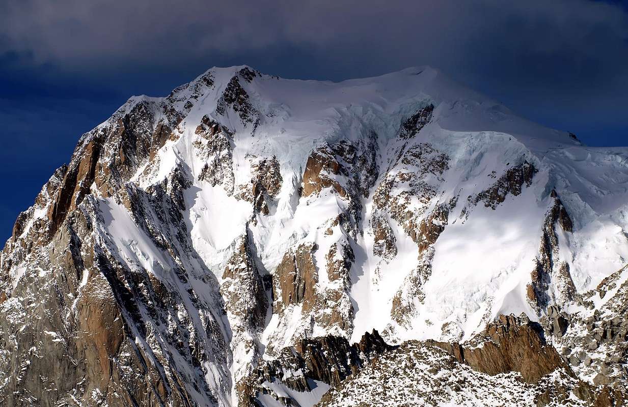
Dome du Gouter (4306m)
/Quota 4282m; Rochers Foudroyès; Grande and Petite Bosse; Pointe Pfann/Rochers du Mont Blanc, Quote various; La Tournette/MONT BLANC MOUNTAIN CHAIN (4808/10m):
la Tourette/Mont Blanc de Courmayeur (4765m).
Brouillard Ridge: Picco Savoia Prince Luigi Amedeo, of Abruzzi Duke (4470m)/
Mont du Brouillard or Breuillat (4068m)
/Quota 4005m/Punta Martino Baretti (4006m)
/Quote 3863, 3790, 3648, 3364, 3349m/Aiguilles Rouges du Brouillard and Southwestern appendages (Quote 3364, 2981 3349, 3098, 2881, 3151, 3110, 2940m).
Innominata Ridge: Pic James Eccles (4045m)
/Punta Innominata/Quotas 3730m the mayor
, 3656, 3617, 3438, 3151, 3388m/Aig. Jean Joseph Croux (3251m)
/Aig. de Chatelet.
Péuterey Ridge: Grand Pilier d'Angle or Quota 4308m/
Aiguille Blanche de Péuterey (4108m)
/L'Epée/Picco Gian Battista and Giuseppe F. Gugliermina (3893m)
; Les Dames Anglaises (L'Isolée, Punta Giacomo Casati, Punta Amilcare Crétier or La Vierge, Punta Antonio Castelnuovo, Punta Savoia Princess Jolanda)/Aiguille Noire de Péuterey (Pointes Edouard Bich, Osvaldo and Arturo Ottoz or Fifth Tower, Karl Brendel or Fourth Tower, Willo Welzenbach or Third Tower) (3773m)
/Pic Gamba or First Tower/Monts Rouges de Péuterey (Quote various, the mayor 2941m); Monts Noirs de Péuterey (North Summit 2955m).
From MONTE BIANCO MOUNTAIN CHAIN before to North, after to East and Tour Ronde: Rochers Rouges (Little, Higher and Lower)/
Mont Maudit (4468m)
/Pointe de l'Androsace; Pic A. W. Moore; Brenva Fourche and Calotta/Brenva Trident.
Great ramification to North-northeast from
Mont Maudit Mont Blanc de Tacul (West 4248m and East Summits)
great inside Area: Aiguilles du Diable (L'Isolée, Pointe Carmen Pointe Lépiney, Pointe Mediane, Pointe J. Chaubert, La Corne du Diable).
Tacul East-northeast satellites: Le Chat/La Pyramide; Les Aiguillettes (Northwest and Southeast);
CAPUCHINS the WAILING of the STONE to the SKY, on AUGUST 10th, 1969
Mount Blanc of Tacul satellites: Grand Capucin (3838m)
/Le Carabinier/Petit Capucin (3693m)
; Roi du Siam; Pic Adolphe (3535m)
; Le Clocher/Le Petit Clocher/La Chandelle/Le Trident du Tacul; Pilier du Diable or Devil Pillar - Three Points Pillar; East Pillar of the Northeast Buttress; Pointe Jean Louis Lachenal (3570m)
; Le Gros Rognon - Petit Rognon towards
Vallée Blanche Glacier.
GREAT CAPUCHIN & Satellites from North Wall of Tour Ronde, on JULY 02th, 1967
Continuation of the great ramification to North from Midi Pass: Cosmiques Refuge and Abrì Simond -
Pointe Paul René - Aiguille du Midi Area: Rognon du Plan - Aig. du Plan (3673m)
; Pain du Sucre - Dent du Requin (3422m)
; Le Chapeau à Cornes; Capucin du Requin - Quote 2851, 2784m - d'Envers des Aiguilles Réfuge. Dent du Crocodile - Aig. du Peigne (3192m)
- Plan de l'Aiguille.
Les Aiguilles de Chamonix Area: Le Caiman - Aiguille de Blaitière (3521m) -
Aiguille du Grépon (3482m)
- Aiguille des Grands Charmoz (3485m)
- Aig. des Petits Charmoz - Frètes des Charmoz; Aig. de la République (3305m)
- Les Cornes des Chamois - Tete de Trélaporte.
Ramification from Mount Maudit to Point Helbronner: Tour Ronde (3798m)
/Pic de la Brenva/Quota 3384m/Le Père Eternel/Aiguille de la Brenva (3278m)
/Tour de la Brenva/Rochers de la Brenva; Aiguille d'Entrèves/Tour d'Entrèves; /Aiguille de(s) Thoule(s)/Grand Flambeau/Petit Flambeau/la Vierge; Punta Helbronner, little Group.
A2b) DENT of GEANT/ROCHEFORT RIDGE/MOUNT MALLET/ROCHEFORT DOME/GREAT JORASSES/HIRONDELLES POINT/LITTLE JORASSES/JORASSES TOWER; AIG. of LESCHAUX-GREUVETTA/AIG. of EBOULEMENT/AIG. of TALEFRE/AIG. of SAVOIE/PAPILLONS POINT/ISABELLA POINT/AIG. of TRIOLET/MOUNT DOLENT/MOUNT GRAPILLON MOUNTAIN CHAIN:
A2b) or 19 From Giant Pass to Point Walker of Grandes Jorasses:
Aiguilles Marbrées North and South/Jetoula Tower and Jag (3342m; 3406m)
; Dente del Gigante (4014m)
/Arete de Rochefort: Aiguille de Rochefort (4001m)
; Mont de Rochefort/Aiguilles Rouges de Rochefort; Dome and Calotte de Rochefort (4014m; 3966m)
/GRANDES JORASSES: Pointes Geoffrey Wintrop Young, Queen Margherita, Duchess Elena, Michel Croz, Edward Wymper and Horace Walker (4208m),
Mountain CHAIN.
Northwestern appendages from Géant Jag: Pointe George Yeld/La Noire.
Northern appendages from Rochefort Crest: Mont Mallet/Pointe Cupelin of the Périades Points/Fenetre Point/Sisyphe Point/Nini Pietrasanta/Pointe Simon/Les Périades. Capucin du Tacul;
Aiguille du Tacul/Clocher du Tacul/Chandelle du Tacul.
Southern Appendages from Helena Point of Great Jorasses: Rochers du Reposoir/Rognon de la Grande Bouteille; Tour des Grandes Jorasses; Prà Sec Crest (Quotas various); Aig. de Tronchey/Aig. de l'Eveque (Quote various).
From Arete des Hirondelles to Mont Dolent: Pointes des Hirondelles/Pointes de Fréboudze or Frébouge South (Corrado Alberico), Central (Guido Antoldi) and North (Luigi Borgna)/Petites Jorasses (3649m)/
Aiguille des Leschaux (3759m)/
Mont Greuvetta (3684m)
/Mont Rouge de Greuvetta (Quotas various); l'Aiguillon/Aiguille de l'Eboulement (3601m)/
AIGUILLE de TALEFRE from N-NE and AIGUILLE de LESCHAUX & JORASSES NORTH Faces, on SUMMER 1993
![]() Aiguille de Talèfre
Aiguille de Talèfre (3730m)
/Aig.de Savoie (3604m)
/Pointe des Papillons South and North/Pointe Isabella South and North/Petites Aiguilles de Triolet Western and Eastern/Aiguille de Triolet (3874m)
/Monts Rouges de Triolet (Quote various, the major 3435m)Aiguilles Rouges de Triolet Northwest and Southeast; Triolet Aiguillon or Quota 3656m/Pointe du Domino/Quota 3613m/Pointe de Pré de Bar/Pointe Superieure de Pré de Bar/Mont Dolent (3749m)/
Mont Grapillon/Quota 3516m/Pointe Gratien Volluz/Petit Grapillon/Punta Allobrogia/Quota 3028m /Quota 2818m/Tete de Ferret.
A2/c)- The COURTES/The DROITES/AIGUILLE VERTE/The DRUS; TOUR NOIR/AIGUILLES of ARGENTIERE/AIGUILLE of CHARDONNET/AIG. of TOUR/AIG.s DOREES MOUNTAIN CHAIN:
a2/c) or 20- French and Swiss Northern appendages of Mount Blanc MOUNTAIN CHAIN:
Domes/Pointe des Lanchettes/Mont Tondu; Aig. de Bellaval/La Grande Ecaille/Pointe de la Tepiaz; Tete d'Enclave/Tete de Bellaval/Tetes des Fours Northeast and Southwest. Domes de Miage/Aig. de la Bérangère/Pointe de Cheuton; Pointe de Covagnet/Mont Truc; Aig. de Tricot/Pointes de Tricot/Mont Vorassay. Aiguille du Gouter/Tete Rousse/Les Rochers Rouges/Quote various/Le Gros Béchar; Arete Pavot/Les Rognes/Mont Lachat; Montagne des Faus; Montagne de Taconnay; Montagne de la Cote. Pointe Capt. Mieulet/Pointe Charles Durier/Aig. Horace Bénedicte De Saussure; Rocher de l'Heureux Retour/Rocher Pitschner/Rocher de Grands Mulets.
Pointe de Talèfre/Aiguilles de Pierre Joseph (Lower, Higher and West Points)/Quota 2940m/Pierre à Beranger/Séracs de Talèfre/Les Egralets/Tete du Couvercle/Le Chien Rouge/Aiguille du Moine/La Nonne/L'Eveque/Le Cardinal/
![]() AIGUILLE VERTE
AIGUILLE VERTE (4121 m),
MOUNTAIN CHAIN: Pointe Croux/Pointe Petigax/Pic Sans Nom/Aiguilles du Drus (Grand and Petit Dru)/Pointe de la Charpoua or Quota 2940 m; Aiguille Carrée/Pointe Farrar/Petite Aiguille Verte/Aiguille des Grands Montets; Aiguille à Bochard. Aiguille du Jardin/Les Droites (4000m)
/Tour des Courtes/Les Courtes (3856m)
/Aiguille Croulante/Aiguille qui Remue/Aiguilles Ravanel/Aiguille Mummery.
of M. Dolent Quote 3074, 2692m/La Maye; Aiguille de l'Amone/Pointe de la Fouly/Grand Gendarme/Pointe Marcel Kurz/Pointe Lagarde/Pointe La Mouche/ Pointe Dalloz/Pointe Morin/Le Tour Noir (3838m);
Pointes des Améthystes Sup. and Inf.; Aiguille de l'A Neuve; Grande Lui/Petit Darrey/Tete Noire or Tita Naire/Pointe de Planereuse Grande and Petite/Clochers de Planereuse/Tete Moutze or Tita Moutse; Grand Darrey/Pointes des Essettes/Pointes des Six Niers.Flèche Rousse/Aiguilles d'Argentière (3902m)/
Aiguille du Chardonnet/Aiguille Adams-Reilly/Aiguille du Passon/Bec Rouge Sup./Quota 3000 m/Bec Rouge Inf./Bec de Lachat; Bec de la Cluy.
Aiguille Forbes/Grande Fourche/Petite Fourche/Aiguille de la Fenetre/Aiguille de la Varappe/Aiguilles Dorées: Tete Biselx/Aiguille de Javelle/Roc des Plines; Pointe des Plines; Pointe des Ravines Rousses/Le Portalet/Ravines Rousses/Clochers du Portalet; Pointe d'Orny/Petite Pointe d'Orny; Aiguille d'Orny/Aiguilles d'Arpette (Quote 3064, 2864, 2627m); Pointes des Chevrettes/Les Sasses: Le Chatelet/Quota 2082m/Tete Moutze or Tita Moutse/Quote 2046, 1629m.
Tete Blanche/Aig. du Col du Tour/Aiguille Purtscheller/Aiguille du Tour (3542m)
/Aig. du Pissoir; le Pissoir; Aiguille de Midi des Grans/Aig. du Génépi/Pointe des Grands/P. de Bron/Bec du Pecheu.
MOUNT BLANC Area
![]() BRENVA Éperon, the First Day of the MOON, on JULY 19/20th, 1969
PART A TWO/a
BRENVA Éperon, the First Day of the MOON, on JULY 19/20th, 1969
PART A TWO/a:
AIG. des GLACIERS/AIG. de TRELATETE/AIG. de BIONNASSAY/MONT BLANC/AIG. BLANCHE de PEUTEREY/MONT MAUDIT/MONT BLANC of TACUL/CAPUCINS and SATELLITES/AIG. of MIDI; TOUR RONDE:
A2a)- From Veny Valley Elisabetta-Soldini Montanaro Refuge - Pyramides Calcaires Higher and Lower; Montagnes des Glaciers - Petite Aig. des Glaciers -
Aiguille des Glaciers; Echellettes and Adolfo Hess Bivouacs -
Aig. de la Lex Blanche
Aiguilles de Trelatete little Area: Northwest, Central, Southeast and East Summits.
From Eastern Summit small ramification to South-southeast: Aiguille de l'Aigle -
Petit Mont Blanc -
Gino Rainetto or du Petit Mont Blanc Bivouac also Giovane Montagna Bivouac in Southwest - Aig. de Combal - Mont Tseuc.
Continuation of the watershed to North-northeast: Tete Carrée -
Domes de Miage - Quote 3834, 3833, 3622, 3814, 3810m -
Durier Refuge, near Miage Pass -
Aiguille de Bionnassay.
Francesco Gonella Refuge in Southeast - Calotte des Aiguilles Grises - Tour des Aig.s Grises - Quote 3676, 3599, 3419, 3138, 3245, 2910m - Chaux de Pesse Group.
Dome du Gouter - Quota 4282m; Rochers Foudroyès -
Vallot Observatoire Refuge; Grande and Petite Bosse; Pointe Pfann; Rochers du Mont Blanc, Quote various -
Quintino Sella Refuge in South; La Tournette -
MONT BLANC: la Tourette -
Mont Blanc de Courmayeur -
Brouillard Arete:
Picco Savoia Prince Luigi
Amedeo, of Abruzzi Duke - Mont du Brouillard or Breuillat - Quota 4005m -
Punta Martino Baretti - Quote 3863, 3790, 3648, 3364, 3349m - Aiguilles Rouges du Brouillard (Summits various).
From Mount Blanc Summit Innominata Ridge -
Pic James Eccles -
Lampugnani-Crippa Bivouac in Southwest -
Punta Innominata - Quote 3730, 3656, 3617, 3438, 3151; 3388m -
Aiguille Jean Joseph Croux - Monzino Refuge - Aig. de Chatelet.
Great ramification to Southeast from
Mount Blanc of Courmayeur Summit Péuterey Great Arete:
Grand Pilier d'Angle or Quota 4308m -
Aiguille Blanche de Péuterey great Area: L'Epée;
Picco Gian Battista and Giuseppe F. Gugliermina - Les Dames Anglaises (L'Isolée, Punta Giacomo Casati, Punta Amilcare Crétier or La Vierge, Punta Antonio Castelnuovo, Punta Savoia Princess Jolanda) -
Aiguille Noire de Péuterey (Pointes Edouard Bich, Osvaldo and Arturo Ottoz or Fifth Tower, Karl Brendel or Fourth Tower, Willo Welzenbach or Third Tower) -
Pic Gamba or First Tower - Monts Rouges de Péuterey (Quote various); Monts Noirs de Péuterey -
Noire Refuge and Borrelli-Pivano Bivouac to South.
MONTE BIANCO great ramification to Northeast: Rochers Rouges (Little, Upper and Lower) -
Mont MAUDIT - Pointe de l'Androsace; Pic A.W. Moore; Brenva Fourche, Calotta and Trident MOUNTAIN CHAIN.
Great ramification to North-northeast: from
Mont Maudit-Mont Blanc de Tacul (West ad East Summits) GREAT Area:
Aiguilles du Diable (L'Isolée, Pointe Carmen Lépiney, Pointe Mediane, Pointe J. Chaubert, La Corne du Diable).
Tacul East-northeast satellites: Le Chat/
La Pyramide; Les Aiguillettes (NW and SE)/
Les Capucins:
Grand Capucin/Le Carabinier/
Petit Capucin;
CAPUCHINS the CRY of the STONE to the SKY, on AUGUST 10th, 1969
Roi du Siam;
Pic Adolphe; Le Clocher/Le Petit Clocher/La Chandelle/
Le Trident du Tacul; Pilier du Diable or Devil Pillar - Three Points Pillar; East Pillar of the Northeast Buttress;
Pointe Louis Lachenal; Le Gros Rognon - Petit Rognon to
Vallée Blanche Glacier.
Continuation of the great ramification to North: from
Midi Pass - Cosmiques Refuge and Abrì Simond -
Aiguille du Midi Area: Rognon du Plan -
Aig. du Plan; Pain du Sucre -
Dent du Requin; Le Chapeau à Cornes; Capucin du Requin - Quote 2851, 2784m -
l'Envers des Aiguilles Réfuge. Dent du Crocodile -
Aig. du Peigne - Plan de l'Aiguille.
Les Aiguilles de Chamonix Area: Le Caiman -
Aiguille de Blaitière -
Aiguille du Grépon -
Aiguille des Grands Charmoz - Aig. des Petits Charmoz - Frètes des Charmoz; Aig. de la République - Les Cornes des Chamois - Tete de Trélaporte.
Ramifications from Mount Maudit to South-southeast: Tour Ronde/Pic de la Brenva - Quota 3384m - Le Père Eternel -
Brenva Bivouac in West -
Aiguille, Tour and Rochers
de la Brenva;
to Southeast: Aig. and Tour d'Entrèves; Aiguille d'Entrèves - Aiguille de(s) Thoule(s) - Grand and Petit Flambeau/la Vierge; Punta Helbronner -
Torino Old and New Refuges, near Giant Pass.
GRANDES JORASSES AREA From GIANT Pass to GREAT FERRET's Pass
GREAT JORASSES from
South-southwest
![]() PART A TWO/b
PART A TWO/b:
DENT of GEANT/ARETE of ROCHEFORT/GREAT JORASSES/LITTLE JORASSES/AIG. of LESCHAUX-GREUVETTA/AIG. of TALEFRE/AIG. of TRIOLET/MOUNT DOLENT:
coloA2b)- Great ramification to East from
Giant Pass: Aiguilles Marbrées North and South/Tour and Dent de Jetoula;
Dente del Gigante or Dent du Géant.
Little ramification to Northwest or of Périades: Quote 3771, 3622, 3618, 3410m - Pointe Geoge Yeld - Quota 3506m - La Noire.
Continuation of ramification to East-northeast Grande Arete de Rochefort: Aiguille de Rochefort.
Ramifications to North: Mont Mallet - Quote 3769, 3597m - Pointe Cupulin - Pointe de la Fenetre -
Périades Bivouac, near Pointe Sisyphe - Pointe Ninì Pietrasanta - Pointe Simond - Pointe des Périades - Qota 3401m - Capucin du Tacul - Quota 2927m; Quota 3235m - Clocher du Tacul - Chandelle du Tacul; Quote various in North.
to South-southeast: Mont de Rochefort - Aig.s Rouges de Rochefort; Dome and Calotte de Rochefort -
Ettore Canzio Bivouac, near Great Jorasses Pass -
GRANDES JORASSES (Pointes Geoffrey Wintrop Young, Queen Margherita, Duchess Elena, Michel Croz, Edward Wymper and Horace Walker Mountain CHAIN.
Southern Appendages:
Rochers du Reposoir - Rognon de la Grande Bouteille Gabriele Boccalatte-Piolti or des Grandes Jorasses Refuge in South-southwest; Tour des Grandes Jorasses; Prà Sec Crest (Quote various); Tronchey Crest - Aig. de Tronchey - Jachia Bivouac in crest - Aig. de l'Eveque (Quote various).
Great ramification to North-northeast: from
Walker Point Arete des Hirondelles - Pointes des Hirondelles - Pointes de Fréboudze or Frébouge South and North - Petites Jorasses -
AIGUILLE de LESCHAUX from N-NE and JORASSES NORTH Face, on JULY 30th, 2001
![]() Aiguille des Leschaux little Area: Giusto Gervasutti Bivouac in South-southeast; Mont Greuvetta - Mont Rouge de Greuvetta (Quote various) Comino Bivouac in Est-southeast. Coninuation of great ramification to North-northeast: from Leschaux Pass L'Aiguillon - Aig. de l'Eboulement -
AIGUILLE de TALEFRE from N-NE and AIGUILLE de LESCHAUX & JORASSES NORTH Faces, on AUGUST 15th, 1985
Aiguille des Leschaux little Area: Giusto Gervasutti Bivouac in South-southeast; Mont Greuvetta - Mont Rouge de Greuvetta (Quote various) Comino Bivouac in Est-southeast. Coninuation of great ramification to North-northeast: from Leschaux Pass L'Aiguillon - Aig. de l'Eboulement -
AIGUILLE de TALEFRE from N-NE and AIGUILLE de LESCHAUX & JORASSES NORTH Faces, on AUGUST 15th, 1985
![]() Aiguille de Talèfre Little Area: Dalmazzi or Triolet Refuge in East-southeast - Aiguille de Savoye - Pointe des Papillons South and North - Pointe Isabella South and North - Petites Aig.s de Triolet Western and Eastern - Aiguille de Triolet little Area: Monts Rouges de Triolet (Quote various, the major 3435m) - Aiguilles Rouges de Triolet Northwest and Southwest; Triolet Aiguillon or Quota 3656m - Pointe du Domino - Quota 3613m - Pointe de Pré de Bar - Pointe Superieure de Pré de Bar - Mont Dolent little Area:
From AIGUILLE de SAVOIE (3604m) to QUOTA 3622m of AIGUILLE de TRIOLET (Spire on Shoulder in SE Crest), MONT DOLENT (3819m), MONT GRAPILLON (3576m) and POINTE GRATIEN VOLLUZ (3358m), on JULY 29th, 2001
Aiguille de Talèfre Little Area: Dalmazzi or Triolet Refuge in East-southeast - Aiguille de Savoye - Pointe des Papillons South and North - Pointe Isabella South and North - Petites Aig.s de Triolet Western and Eastern - Aiguille de Triolet little Area: Monts Rouges de Triolet (Quote various, the major 3435m) - Aiguilles Rouges de Triolet Northwest and Southwest; Triolet Aiguillon or Quota 3656m - Pointe du Domino - Quota 3613m - Pointe de Pré de Bar - Pointe Superieure de Pré de Bar - Mont Dolent little Area:
From AIGUILLE de SAVOIE (3604m) to QUOTA 3622m of AIGUILLE de TRIOLET (Spire on Shoulder in SE Crest), MONT DOLENT (3819m), MONT GRAPILLON (3576m) and POINTE GRATIEN VOLLUZ (3358m), on JULY 29th, 2001
![]() Mont Grapillon Fiorio Bivouac & Dolent Refuge in Southeast - Quota 3516m - Pointe Gratien Volluz - Petit Grapillon - Punta Allobrogia - Quota 3028m Mountain Chain to Great Ferret Pass.
Mont Grapillon Fiorio Bivouac & Dolent Refuge in Southeast - Quota 3516m - Pointe Gratien Volluz - Petit Grapillon - Punta Allobrogia - Quota 3028m Mountain Chain to Great Ferret Pass.
AIGUILLE VERTE AREA and APPENDANGES FRENCH & SWISS of the MONT BLANC
VERTE & DRUS
![]() PART A TWO/c: AIGUILLES de CHAMONIX/AIGUILLE VERTE/LES DRU; TOUR NOIR/AIGUILLES d'ARGENTIERE MOUNTAIN CHAINS:
A2c)-French and Swiss appendages. Mount Blanc Northern appendages: Domes - Pointe des Lanchettes - Mont Tondu; Aig. de Bellaval - La Grande Ecaille - Pointe de la Tepiaz; Tete d'Enclave - Tete de Bellaval - Tetes des Fours NE and SW. Domes de Miage - Aig. de la Bérangère - Pointe de Cheuton; Pointe de Covagnet - Mont Truc; Aig. de Tricot - Pointes de Tricot - Mont Vorassay. Aiguille du Gouter - Aiguilles du Gouter Refuge - Les Rochers Rouges; ramification to North: Quote 3257, 3154, 3025, 2829, 2765m - Le Gros Béchar. Tete Rousse - Tete Rousse Refuge - Les Rognes Baraque Forestière des Rognes - Le Nid d'Aigle - Mont Lachat; Montagne des Faus; Montagne de Taconnay; Montagne de la Cote. Pointe Bayeux; Pointe Bravais; Les Grands and Les Petites Montées - Rocher de l'Heureux Retour Rocher Pitschner - Les Grands Mulets - Grands Mulets Refuge - La Jonction. Pointe Capt. Mieulet - Pointe Charles Durier - Aig. Horace Bénedicte De Saussure.
Pointe de Talèfre - Aiguilles de Pierre Joseph (Lower, Higher and West Points) - Leschaux Refuge- Quota 2940m - Pierre à Beranger - Séracs de Talèfre - Les Egralets - Tete du Couvercle - Le Chien Rouge - Couvercle Réfuge in South - Aig. du Moine - La Nonne - L'Eveque - Le Cardinal/AIGUILLE VERTE Mountain CHAIN: Pointe Croux - Pointe Petigax - Pic Sans Nom/Aiguilles du Drus (Grand and Petit Dru) - Pointe de la Charpoua or Quota 2940m; Aig. Carrée - Pointe Farrar - Petite Aig. Verte - Aig. des Grands Montets; Aig. à Bochard; Aig. du Jardin - Les Droites - Les Courtes - Aig.s Ravanel.
From Mont Dolent North-northwestern branch: Tour Noire - Aiguilles d'Argentière Area.
PART A TWO/c: AIGUILLES de CHAMONIX/AIGUILLE VERTE/LES DRU; TOUR NOIR/AIGUILLES d'ARGENTIERE MOUNTAIN CHAINS:
A2c)-French and Swiss appendages. Mount Blanc Northern appendages: Domes - Pointe des Lanchettes - Mont Tondu; Aig. de Bellaval - La Grande Ecaille - Pointe de la Tepiaz; Tete d'Enclave - Tete de Bellaval - Tetes des Fours NE and SW. Domes de Miage - Aig. de la Bérangère - Pointe de Cheuton; Pointe de Covagnet - Mont Truc; Aig. de Tricot - Pointes de Tricot - Mont Vorassay. Aiguille du Gouter - Aiguilles du Gouter Refuge - Les Rochers Rouges; ramification to North: Quote 3257, 3154, 3025, 2829, 2765m - Le Gros Béchar. Tete Rousse - Tete Rousse Refuge - Les Rognes Baraque Forestière des Rognes - Le Nid d'Aigle - Mont Lachat; Montagne des Faus; Montagne de Taconnay; Montagne de la Cote. Pointe Bayeux; Pointe Bravais; Les Grands and Les Petites Montées - Rocher de l'Heureux Retour Rocher Pitschner - Les Grands Mulets - Grands Mulets Refuge - La Jonction. Pointe Capt. Mieulet - Pointe Charles Durier - Aig. Horace Bénedicte De Saussure.
Pointe de Talèfre - Aiguilles de Pierre Joseph (Lower, Higher and West Points) - Leschaux Refuge- Quota 2940m - Pierre à Beranger - Séracs de Talèfre - Les Egralets - Tete du Couvercle - Le Chien Rouge - Couvercle Réfuge in South - Aig. du Moine - La Nonne - L'Eveque - Le Cardinal/AIGUILLE VERTE Mountain CHAIN: Pointe Croux - Pointe Petigax - Pic Sans Nom/Aiguilles du Drus (Grand and Petit Dru) - Pointe de la Charpoua or Quota 2940m; Aig. Carrée - Pointe Farrar - Petite Aig. Verte - Aig. des Grands Montets; Aig. à Bochard; Aig. du Jardin - Les Droites - Les Courtes - Aig.s Ravanel.
From Mont Dolent North-northwestern branch: Tour Noire - Aiguilles d'Argentière Area.COMPLETE WORKS & OPERA SUMMARY - BOOKS & MAPS
Idealization, texts of the Omnia Work, by Osvaldo CARDELLINA.
Mountain Chains Colorphotos, colorpictures, B&W photographs, by Antonio GIANI, Emilio BERTONA & Osvaldo CARDELLINA.
Action photographs & other, by Various AUTHORS & WRITERS:
"MONT BLANC: Brouillard/Freney Slopes", by Gianni JUNOD;
"MONT BLANC Old Summit 4810 m", by Ilario Antonio GARZOTTO;
"BRENVA the FIRST DAY of the MOON", by Ilario Antonio GARZOTTO;
"LESCHAUX-JORASSES-TALEFRE from NORTH 1993, by Camillo Roberto FERRONATO;
"From AIGUILLE of TALEFRE, before STORM 1985,by Camillo Roberto FERRONATO;
"TACUL's LITTLE CAPUCHIN (3693m) EAST FACE, Giusto Gervasutti/Giorgio Gagliardone Route", by Ilario Antonio GARZOTTO;
"Osvaldo Cardellina sulla...", by Ilario Antonio GARZOTTO;
"GREAT CAPUCHIN from LITTLE", by Ilario Antonio GARZOTTO;
"Osvaldo Cardellina sulla..." (bis), by Ilario Antonio GARZOTTO;
"GE'ANT JAG from CAPUCHIN SUMMIT", by Ilario Antonio GARZOTTO;
"LITTLE CAPUCHIN SUMMIT, after Gervasutti Route on Summer 1969", by Ilario Antonio GARZOTTO;
" nei pressi del colle della...", by Ilario Antonio GARZOTTO; "MOUNT BLANC EAST BRENVA's FACE", by Ilario Antonio GARZOTTO;
"BRENVA exit out from plateau to seracs, by MOON", by Ilario Antonio GARZOTTO;
"BRENVA", by Ilario Antonio GARZOTTO
"CAPUCHINS & TACUL SATELLITES", by Ilario Antonio GARZOTTO;
"MOUNT BLANC SUMMIT after BRENVA", by Ilario Antonio GARZOTTO;
"Osvaldo Cardellina sulla...", by Ilario Antonio GARZOTTO
"AIGUILLE des GLACIERS, near the SUMMIT", by Camillo Roberto FERRONATO;
"AIGUILLE des GLACIERS BRITISH REMAINS", by Camillo Roberto FERRONATO;
"AIGUILLE des GLACIERS GREAT TRAVERSE 1979", by Camillo Roberto FERRONATO
"GREAT JORASSES East Face JULY 2010", by Camillo Roberto FERRONATO;
"SOURCES of the Fréboudz(g)e Glacier and Great Jorasses Eastern Face JULY 2010", by Camillo Roberto FERRONATO;
"New DAWN from Mount Blanc of Tacul 1973", by Marco COSSARD;
"Cesare DALMAZZI REFUGE (2584m)", by Sergio MILANI;
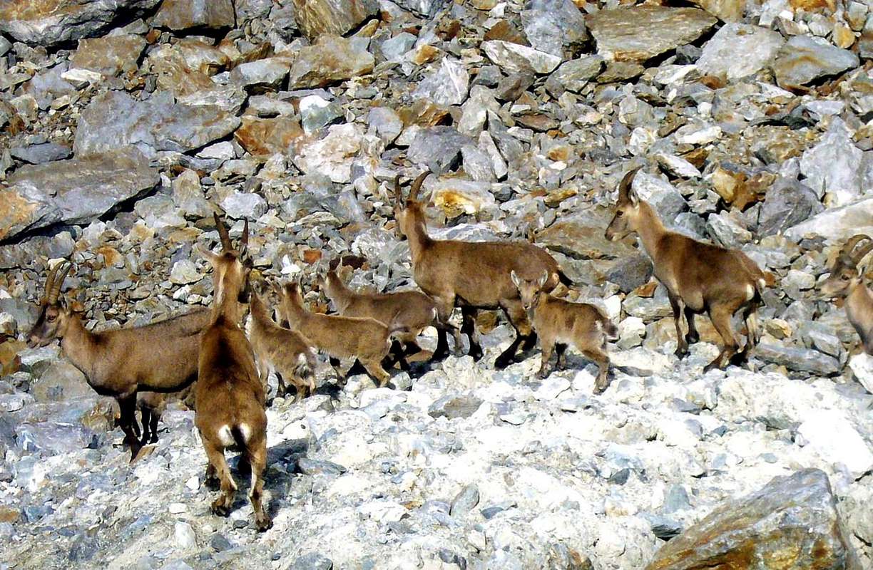
"MIAGE's FEMALES STEINBOCKS & CUBS", by Camillo Roberto FERRONATO;
"PREUSS ROUTE in the MID of the EDGE", by Sergio MILANI;
"AIGUILLE de SAVOIE (3604m) SE WALL to TRIOLET GLACIER", by Sergio MILANI;
"ANCIENT SILVER MINE", by Camillo Roberto FERRONATO;
"AIGUILLE de SAVOIE (3604m) PREUSS ROUTE", by Sergio MILANI;
"PAULI PREUSS ROUTE modern artifices", by Sergio MILANI;
"AIGUILLE de SAVOIE in SAFETY REST", by Sergio MILANI;
"AIGUILLE de SAVOIE (3604m) to TRIOLET GLACIER", by Sergio MILANI;
"AIGUILLE de SAVOIE (3604m) DESCENT for MANU", by Sergio MILANI;
"AIGUILLE de SAVOIE (3604m) to SUMMIT", by Sergio MILANI;
"AIGUILLE de SAVOIE (3604m) INDIAN FILE CLIMBING", by Sergio MILANI;
"AIGUILLE de SAVOIE (3604m) PREUSS ROUTE DESCENT", by Sergio MILANI;
"TACUL's TRIDENT (3693m) Lépiney Route on May 1969", by Ilario Antonio GARZOTTO
"MOUNT BLANC Brenva at beginning of the terminal serac", by Ilario Antonio GARZOTTO;
"TOUR RONDE North Face", by Ilario Antonio GARZOTTO;
"Exit out from North icy Wall", "GABRIELE BOCCALATTE-MARIO PIOLTI also of GREAT JORASSES REFUGE on 1967", by Ilario Antonio GARZOTTO;
"CAMILLE to SILVERMINE", by Mario MOCHET;
"Up the BIONNASSAY GLACIER", by Mario MOCHET;
"N-NW Edge of Little Flambeau l(3437m) up Giant Glacier", by Franco LUCIANAZ;
"GIANT's JAG NE Edge and ROCHEFORT Crest", by Camillo Roberto FERRONATO;
"AIGUILLE de SAVOIE (3604m) VARIAOUS ROUTES from SE", by Camillo Roberto FERRONATO;
"FREE CLIMBING on the first SPUR of MONT ROUGES of TRIOLET", by Franco LUCIANAZ;
"Lex Blanche SERACS", by Camillo Roberto FERRONATO;
"AFTER one MONTH", by Franco LUCIANAZ;
"Pyramide du Tacul from Petit Capucin 1969", by Ilario Antonio GARZOTTO;
"MIAGE LAKE near MIAGE's GARDEN and OFFSPRING of the MIAGE GLACIER, on JULY 1974", by livioz;
"M.BLANC / G. JORASSES / AIG. VERTE Capuchins 1967", by Ilario Antonio GARZOTTO;
"Colle Brenva", by besucher01;
"Verso il colle Freshfield", by Antonio GIANI;
"Mont Blanc Group, italian side full view", by as;
"MOUNT BLANC ... Aiguille Noire & Aig. of Brenva 2006", by Camillo Roberto FERRONATO;
"MOUNT BLANC again Blanche & Noire of Péuterey 2000", by Camillo Roberto FERRONATO;
"A. Noire ... an hour and a half before his death 1969", by Ilario Antonio GARZOTTO;
"Dent du Géant Northeast Edge 1994", by Hans MARGUERETTAZ.
BASE BOOKS & MAPS
BASE BOOKS:
"Voyages dans les Alpes", by Horace Bénedict De Saussure, Tome I 1779, Tome IV 1796;
"Manuel du voyageur en SUISSE et à Chamonix" - Nouvel Ebel, by Adolphe Joanne, Second Edition 1859;
"La Vallée d'Aoste", by Edoard Aubert, 1860;
"A Handbook for Travellers in Switzerland, Savoye, and Piedmont", by John Murray, Twelfth Edition 1867;
"Studi sul Gruppo del Gran Paradiso", by Martino Baretti, 1867;
"Historique de la Vallée d'Aoste", by Jean Baptiste De Tillier, 1888;
"Climbers' Guide to the Central Pennine Alps", by William Martin Conway, 1890;
"The Mountains of Cogne", by George Yeld and W.A.B. Coolidge, 1893;
"Guida delle Alpi Occidentali Vol. II°, Parte 2°, by Giovanni Bobba and Luigi Vaccarone, 1896;
"Scrambles in the Eastern Graians 1878-1897", by George Yeld, 1900;
"Nel Regno del Cervino", by Edmondo De Amicis, 1905;
"Les Alpes Occidentales", by Federico Sacco, 1913;
"Guide du Valpelline", by Abbot Joseph Maria Henry, 1925;
"Le Alpi Pennine", by Silvio Saglio, 1951;
"La Luce delle vette", by Francesco Cavazzani, 1954;
"Guida della Regione Autonoma della Valle d'Aosta", by Mario Aldrovandi, 1964;
Monte Marzo e la cresta dal Colle dei Corni al Colle di Valbella", by Piero Falchetti, 1966;
"Dal Bec d'le Steje alla Cima Battaglia", by Piero Falchetti, 1968;
"Gran Paradiso - itinerari scelti", by Roberto Mantovani and Renato Misischi, 1974;
"80 itinerari di escursionismo alpinismo sci alpinismo in valle d'aosta", by Osvaldo Cardellina, 1977;
"Guida del Monte Emilius, by Osvaldo Cardellina, 1978.
C.A.I./T.C.I. Collana Guide dei Monti d'Italia-Italy's of the Mounts Guides SERIES, Volumes:
"Monte Rosa", by Sivio Saglio and Felice Boffa, 1960;
"Gran Paradiso", by Emanuele Andreis, Renato Chabod and Mario Carlo Santi, 1939; Reprint 1963;
"Monte Bianco Volume I°", by Renato Chabod, Laurent Grivel and Silvio Saglio, 1963;
"Aggiornamenti alla Guida del Gran Paradiso (Seconda Edizione)", by Renato Chabod and Piero Falchetti, 1964;
"Monte Bianco Volume II°", by Renato Chabod, Laurent Grivel, Sivio Saglio and Gino Buscaini, 1968;
"Alpi Pennine Volume II°", by Gino Buscaini, 1970;
"Alpi Pennine Volume I°, by Gino Buscaini, 1971;
"Gran Paradiso", by Emanuele Andreis, Renato Chabod and Mario Carlo Santi, Third Edit. with revisions and collaborations by Renato Chabod, Ugo Manera and Corradino Rabbi, 1980;
"Alpi Graie Centrali", by Alessandro Giorgetta, 1985;
"Monte Rosa e Mischabel", by Gino Buscaini, 1991;
"Monte Bianco Volume I°", by Gino Buscaini, 1994;
"Emilius Rosa dei Banchi Parco del M. Avic", by Giulio Berutto and Lino Fornelli, 2005.
BASE MAPS
- Les cartes DEPARTEMENTS France n° 333 Michelin "Isère, Savoie", 1:150.000.
- Les cartes DEPARTEMENTS France n° 328 Michelin "Ain, Haute-Savoie", 1:150.000.
- Carta del T.C.I. allegata a Monte Bianco Volume I", 1964, nella "Guida dei Monti d'Italia 1:50.000.
- Carta del T.C.I. allegata a Monte Bianco Volume II", 1968, nella "Guida dei Monti d'Italia 1:50.000.
- Kompass "Massiccio del Monte Bianco Valle d'Aosta Sentieri e Rifugi" Carta turistica 1:50.000.
- I.G.C. Istituto Geografico Centrale Torino "Massiccio del Monte Bianco" (n° 4), Torino, 1998 1:50.000.
- I.G.C. Istituto Geografico Centrale Torino "Monte Bianco-Courmayeur-Chamonix-La Thuile" (n° 107), 1:25.000.
- Kompass "Massiccio del Monte Bianco Valle d'Aosta" Carta escursioni, bike e sci alpinismo 1:50.000.
- L'Escursionista "Monte Bianco Courmayeur" (n° 1) Edizioni Rimini 2004 1:25.000.
- IGN Carte de randonnée CHAMONIX - MASSIF DU MONT BLANC 3630 OT 1:25.000.
- Edizioni Tabacco "Mont Blanc" Udine, 1978 1:50.000.
- Studio F.M.B. Bologna 1988 "Monte Bianco-Mont Blanc" 1:50.000.
- IGN institut géographique national grenoble mont-blanc parc national de la vanoise (n° 53), 1:100.000.
- Hapax "Comunità Montana Valdigne Mont - Blanc Cartografia Escursionistica" (territorio Sentieri & natura della Comunità), Aosta 2009 1:50.000.
- "Carta Turistica della Valle d'Aosta", della Regione Autonoma della Valle d'Aosta Assessorato al Turismo, a cura di Alessio Nebbia; Istituto Geografico De Agostini Novara, 1957 1.100.000

 15667 Hits
 84.27% Score
 18 Votes