
-
 12000 Hits
-
 81.84% Score
-
 14 Votes
|
|
Mountain/Rock |
|---|---|
|
|
32.03390°N / 110.1157°W |
|
|
Cochise |
|
|
Hiking |
|
|
Spring, Fall, Winter |
|
|
5846 ft / 1782 m |
|
|
Overview
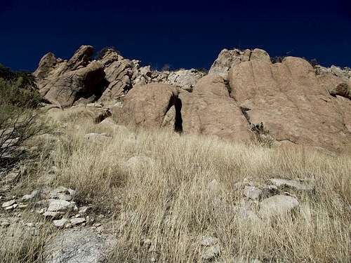 Outcrops on Adams Peak
Every day, thousands of drivers on I-10 east of Benson, Arizona, roar past Adams Peak. The 1,000k+ prominence desert peak rises just to the north of the interstate and blends readily into the surrounding desert scenery. While the hoodoo outcrops of Texas Canyon impress, this Little Dragoon Mountains peak quietly takes its place among the rolling range land, grasses, and yucca.
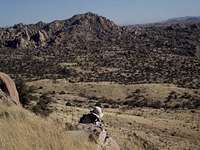
Although it rises rather abruptly from the dry grassland below, Adams Peak is a gentle desert mountain, it’s summit accessible as a walk-up. The summit is wide-open, affording fantastic, 360-degree views, and marred only by the remnants of an old communications tower. Views include neighboring Little Dragoon Mountains highpoint Mae West Peak, the Dragoon Mountains, dynamite views into Texas Canyon, and vistas of seemingly never-ending range-and basin terrain all around.
Arizona Rank: 2051st highest peak in Arizona
Prominence: 1,026 feet
USGS Quad: Dragoon
Rank & Prominence: Lists of John
Getting There
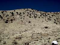 Eastern slopes of Adams Peak
 Summit from saddle
Adams Peak is about 1 hour east of Tucson on I-10 at the Dragoon Road exit. Do not proceed any further without permission from the Adams Ranch to access the peak. Out of respect for the property owner, I will not post precise details of the route.
 Leaving Adams Ranch Leaving Adams Ranch | 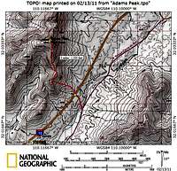 Route Map Route Map |  Northern culvert entrance Northern culvert entrance |
Red Tape
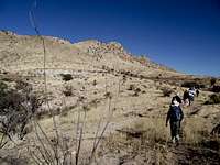
 Lower eastern slopes
 West from the saddle
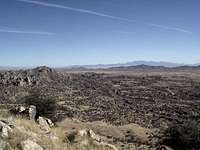 NE up I-10
 From the summit to Little Dragoons
 North toward Little Dragoons
 SSW from summit
Adams Peak is not included in the Coronado National Forest. The summit area is within leased state lands and eastern access crosses private property owned by the Adams Ranch.
Groups such as the Southern Arizona Hiking Club and affiliates have worked hard to periodically obtain permission to climb Adams Peak. In fact, during our visit in the spring of 2011, we thanked the property owners by chain-sawing a tree that had blocked the ranch road, then we moved the wood out of the roadway. Do not jeopardize the fruits of the hard work of SAHC members and others by trespassing on this peak. Respect the private property owner’s rights.
The point to all of this is that this 1,000 foot prominence peak can indeed be accessed legally, with the property owner’s blessing, but it is incumbent upon those of us in the climbing community to play by the rules to ensure we maintain a positive relationship with the property owner. One option for accessing this peak is to coordinate your visit with a visit by the SAHC. If you are an AZP1K list chaser, you may reach out to the Adams Ranch directly, but I urge you to be patient and polite, and to consolidate our visit with that of as many other climbers as possible to minimize the annoyance our strange hobby may have to the ranch owners. Otherwise, if you are simply looking for a nice hike within an hour of Tucson, and you have no interest in obtaining all 1,000 foot prominence peaks in Arizona, there are many other peaks to choose from that do not involve navigating these access issues.
Camping
 UN 5580 is a striking peak
 UN 5529 "Behind the House Hill"
There is no National Forest or BLM camping near Adams Peak.
Benson, Arizona, has several “mom & pop” RV-type campgrounds available:
• Benson KOA
• Pato Blanco RV Resort
• Butterfield RV Resort
Kartchner Caverns State Park, nine miles south of I-10, has tent and RV camping. Note that all sites are developed for full hookups and charged for accordingly.
Weather & Seasons
 | Winter is a great time to visit Adams Peak, with average daytime highs in the 60s. With an elevation over 4,000 feet above sea level, Benson summers are a bit cooler than those in nearby Tucson. Still, the record high temperature recorded in Benson was a blistering 111°F*. Do not visit this peak in the summer. *Source: Weather.com |  |
External Links and Additional Information
 UN 5580 in background
 West toward Rincons
• More about the Little Dragoon Mountains
• Coronado National Forest locations map
 USGS Marker USGS Marker |  Desert Cap'n Morgan Desert Cap'n Morgan |  Summit Summit |
surgent - Mar 28, 2011 2:47 pm - Voted 10/10
Bad linkYour Southern AZ Hiking Club link seems to include too much in its URL. Thx for posting this page. I've been through Texas Canyon often, never knew how to get beyond it due to private lands. Looks like a fun peak, probably better than Mae West.
Sarah Simon - Mar 28, 2011 3:48 pm - Hasn't voted
Re: Bad linkScott: Thanks for the catch! I fixed the bad link/code. It was really good luck that I was in AZ when the SAHC got permission for this climb. The Texas Canyon area is so lovely ... I respect the wishes of the private property owners, but do also wish that it was easier for the public to enjoy this amazing area. Sarah