
|
|
Mountain/Rock |
|---|---|
|
|
41.11363°N / 115.70837°W |
|
|
Elko |
|
|
8135 ft / 2480 m |
|
|
Overview


The Adobe Range High Point has as elevation of 8,135 feet and is located 20 miles north-northeast of Elko in northeastern Nevada. With a prominence of 2,075 feet, it is included on the list of Nevada’s 172 prominent peaks.
The Adobe Range is a minor mountain range of typical sagebrush steppe vegetation, trending in a general north-south direction. Most of the Adobes are a checkerboard of public (Bureau of Land Management) and private ownership. This pattern is attributed to the Pacific Railway Act of 1862, where the federal government gave railroad companies free land in alternating sections as an incentive and a means to finance the overwhelming task of linking east with west by rail. Although more than half of the hiking route to the high point – including the summit itself – falls within privately-owned lands, there are at this time no issues with access. Please always treat the lands, regardless of ownership, with respect.
The Adobe Range is home to one of the largest wintering antelope herds in the state, so there is a very good possibility of seeing antelope here if you come before the vegetation dries in the summer heat and the antelope migrate north. This area is also habitat for mule deer and other species of wildlife.
There is a small rock pile vice a cairn on the summit. Interestingly, a prominent cairn graces the false summit to the northeast. Not sure why it’s there, it just is. A register enclosed in a glass jar is tucked into the rock pile. Considering its close proximity to Elko, I was very surprised to see that the register, placed there in July 1997, had a grand total of five entries: three in 1997 when the register was placed, one in September 2001, and one in May 2006.
 Summit view to NE. Summit view to NE. |
 Summit view to S. Summit view to S. |
 Summit view to SW. Summit view to SW. |
Getting There

From I-80 east of Elko, take the Ryndon interchange (exit 314), turn and head north on Coal Mine Road for 8.6 miles; veer left at the Y-intersection and proceed northwest for 6.2 miles, entering Coal Mine Canyon; turn left at the intersection onto the Jeep trail and head west for 2.7 miles. You might be able to get by without 4WD on this stretch but will need high clearance. Park at the end of the two-track road on the ridge northeast of the high point. Please drive with caution as there is open rangeland in the area.
Here are some topo maps for reference which cover the driving route from the Y-intersection and the hiking route.
 Route map 1 of 3. Route map 1 of 3. |
 Route map 2 of 3. Route map 2 of 3. |
 Route map 3 of 3. Route map 3 of 3. |
Route
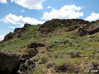
From the end of the Jeep trail, head southwest staying along the north side of the ridge. The elevation gain for the first three-fourths of a mile is slight and gradual. Staying well below the rock formations at the top of the ridge to your left, shoot for the saddle that will come into view as you gain elevation. Once you gain the saddle, transition to the south side of the ridge and continue southwest just below the rocky ridgeline. The first prominence south of the saddle is a false summit. The next prominence, to the southwest, is your objective.The majority of the route is Class 1 with some Class 2 mixed in near the end of the route where the terrain becomes increasingly rockier. Although there is no trail, route finding is not difficult and the terrain provides good footing for the most part. There are some areas of fairly dense vegetation, including sagebrush that you’ll have to contend with, but it doesn’t qualify for even minor bushwhacking. Overall, a simple route with just enough rocks thrown in at the end to make it somewhat interesting.
Route distance is 1.75 miles one-way with a net elevation gain of 889 feet.
 Route view 1. Route view 1. |
 Route view 2. Route view 2. |
 Route view 3. Route view 3. |