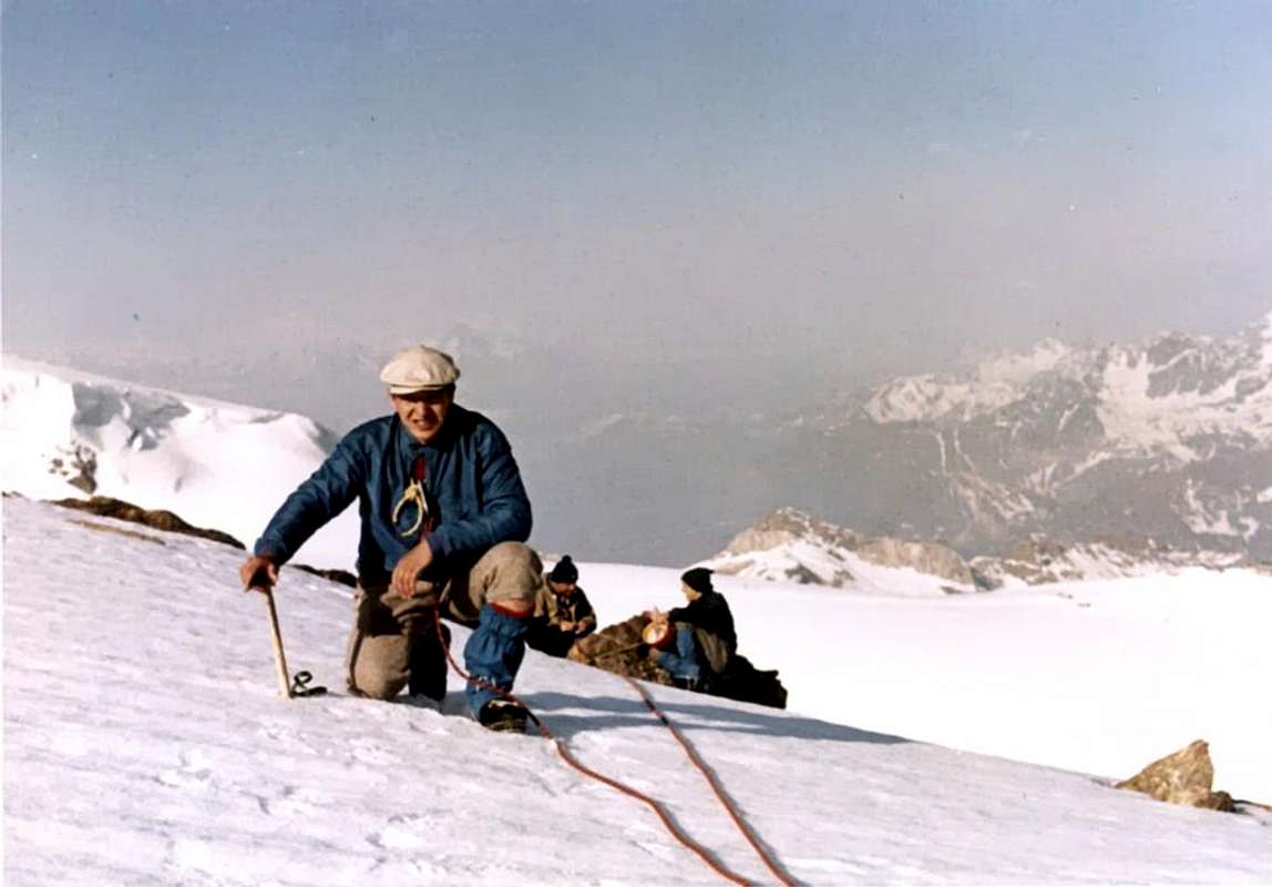
La montagna chiama i suoi figli, ed essi rispondono fedelmente al suo appello…
Osvaldo Cardellina, Diario alpinistico, 1964-65
Page texts: @ OsvaldoCardellina"Osva", passed away on May 2, 2022. Page owners: Christian Cardellina e Osvaldo Cardellina. Any updates from September 12, 2022: Antonio Giani, page administrator, friend and climbing companion.
Testi della pagina: @ OsvaldoCardellina "Osva", scomparso il 2 maggio 2022. Proprietari pagina:Christian Cardellina e Osvaldo Cardellina. Eventuali aggiornamenti dal 12 settembre 2022: Antonio Giani, amministratore della pagina, amico e compagno di salite.
Overview
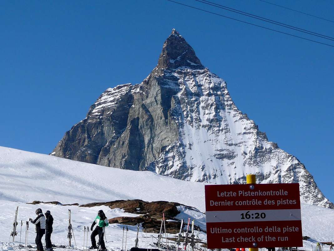
The Klein Matterhorn, also called Piccolo Cervino, is a small Summit but tall mountain, few fluorescent from Midday, or on the slope of the Valley of Aosta, but well in seen from North or Switzerland with his Walls North-northwest and Northeast in great evidence. "Crushed" from the glacial masses of the three Breithorns to East and, to West, from the very famous rocky pyramid of the Cervino, or Matterhorn, appears, amiss, what secondary Top. As to say "When the Great ones make to feel more and more the small ones tiny." In effects, if isolated in other environment, the mountain would assume well different proportionalities and considerations. His Normal Route along the Southern Slopes, impending the Plateau Rosà, also known as Heaven and Paradise of the skiers, is of easy route, while on the West Slope and on the Crest Northwest introduces interesting itineraries and "didactic" for the starting to the discipline of the mountaineering; well different the streets around two Slopes Northerner, with more than few difficulties and men to be asked for preparation and experience of Tall Mountain. Dark complementary ascension to the slope of the two Breitorns Westerner results and Central (generally to the reentry from these to close in beauty the trip of the day) that not elegant destination to herself; while it is becoming trip "complete", and also from us recommended, to go out of the usual and banal and stereotyped schematism with slope or of the Breithorn "Occidentale" or of the Little Cervino; it deals with to beautiful run against the time, causes the schedule of closing of the Cableway of Plan Maison to the reentry, the whole turn of the Breithornplateau with departure and return to the Testa Grigia (3.480m), as well as with circular run climbing in succession the Hump of Rollin, the two Breithorns West and Central to concludes with the Klein Matterhorn. However, departing from the Shelter of the Teodulo, Khan satisfy through to slope for the itineraries of which above, such to offer brief enough profitable and scrambled such to be justified the stay in to shelter. Otherwise, the existence of the "Funivia" or Cableway of Plan Maison frustrates this purpose reducing the trip to crossed by to effect in day. Interesting the "tour" glacial in sense counterclockwise that it foresees the slope of the Hump of Rollin, the Breithorns to end himself with the Little Cervino, as just rendered explicit above. Unfortunately the mountain has been defaced by a whole series of infrastructures for the ski, that you they wind it both to North on the Swiss slope that to Midday toward Italy, but also always in complete Swiss territory, because the crest watershed that originates from the Cervino passes for the Grey and continuous Head or Testa Grigia toward the Hump also Gobba of Rollin (3.902m) for then, crossing the Breithornplateau toward Northeast, to go down and to go up again in direction of the Western Breithorn (4.165m), where he returns to be more clearly marked. This whole area is studded by fittingses of gone up again with sundry ski lift that connects him between them, while a great Cableway, homologous of that that climbs to Plan Maison and the Testa Grigia from Breuil-Cervinia, salt with a first stump from Zermatt up to the Furgg (2.432m) and from this to the Trockener Steg (2.895m); a last line, passing near the Gandegghutte, it crosses the Unterer Theodulgletscher for finally, with a great "flight airplane" to slip himself in the Northern abdomen of the Klein Matterhorn, immediately under the Peak, going out then to South of it with another entrance. The zone results therefore rather frequented by the masses but, little by little that, rotating from North South and then to Northeast toward the wild Glacier of the Kleinmatterhorngletscher, situated among the Little Cervino and the Breithorn West, the rough odor of savage is perceived that the Nature still knows always how to express, in spite of the man.
HISTORICAL NOTES & REMARKS
Its first slope is that belongs some dawns of the birth of the Mountaineering and you is dated August of 1792 from the Naturalist of Geneva Horace Bénedict De Saussure with its seven Swiss Guides; as for the not very distant Mont Velan, climbed later seven years by the Naturalist-monk of the Hospice of the Great Saint Bernard Laurent-Joseph Murith with the Hunter Genoud, it constitutes that primordial phase of scientific exploration of the Alps, such to open it brings it to the following one of conquest of the most famous peaks; and so "they capitulated", in succession, the Westerner Breithorn (Aug 1813), the Point Zumstein (Aug 1819), the Point Gnifetti (Aug 1842), the Dufourspitze, maximum peak of the Chain of the Rosa Mountain (Aug 1855), the Grand Combin of Grafeneire (Jul 1859), the Point Nordend (Aug 1861), the Lyskamms Oriental (Aug 1861) and Western (Aug 1864), the Dent of Hèrens (Aug 1863) in a "crescendo" that to the great conquest of Jul 14th, 1865 with the slope of the "Gran Becca" also called Cervino, known in the world as Matterhorn. This was the term of the conjunction of two epoches: that of the exploratory phase, to which the Klein Matterhorn and that belong burdens conquest phase of the most beautiful and tall peaks in the Alps Pennine, in specific. Blackberries in there in the time the Winter Mountaineering will also develop him and to record the slope of the "our" will be had to attend the Jan of 1889, protagonists still three Swiss mountain climbers.
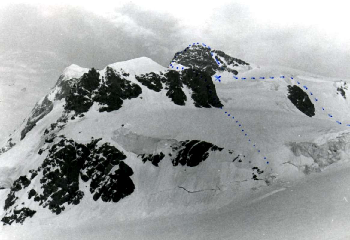
We will effect a brief, short, detailed but synthetic description of all the routes for the mountain existing, departing from the Slope South-southwest or By Standard that he develops on the easy slant of the Breithorn with his Plateau and, rotating clockwise, we will analyze the departures that happen from the Glaciers of the Plateau Rosa, de Saint Théodule and from the Kleinmatterhorngletscher. Good "belvedere" or lookout of tall quota with great sights on the South and East Walls of the near Cervino, as well as on all the "colossuses" of the Vallese.
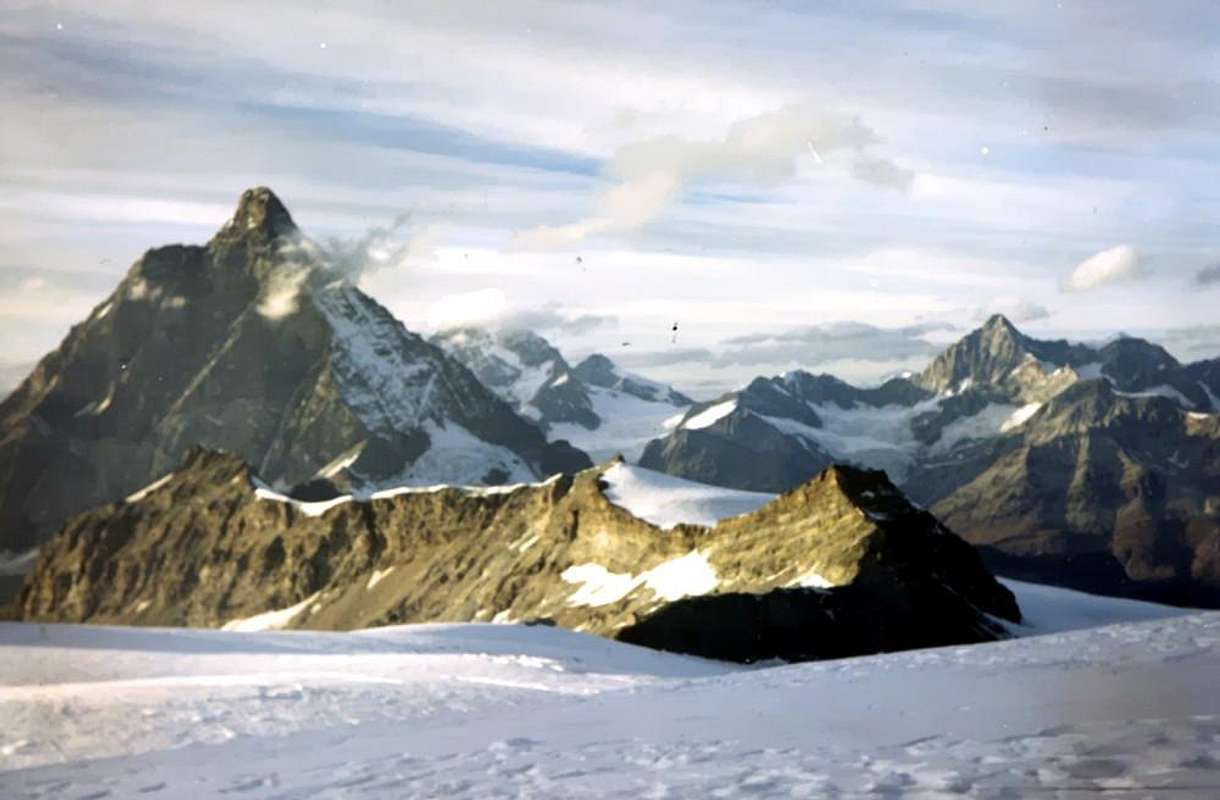
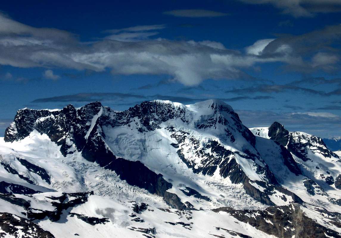
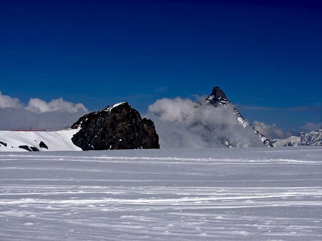
With East-southeastern View left/right: from Klein Matterhorn, near the Summit, to Matterhorn & Obergabelhorn; in bottom the frontier Italian/Swiss Watershed with the Testa Grigia, by Gianni Junod.
Il Klein Matterhorn, conosciuto dagli alpinisti italiani più come Piccolo Cervino é piccola Sommità ma alta montagna, poco appariscente da Mezzogiorno, ovvero sul versante valdostano, ma ben in vista da Settentrione o Svizzera con le sue Pareti Nord-nordovest e Nordest in grande evidenza. "Schiacciata" dalle masse glaciali dei tre Breithorns ad Oriente e dalla celebre piramide rocciosa del Cervino, o Matterhorn, ad Occidente, appare, erroneamente, quale Cima secondaria. Come dire "Quando i Grandi fanno sentire i piccoli sempre più piccini". In effetti, se isolata in altro ambiente, la montagna assumerebbe ben diverse proporzionalità e considerazioni. La sua Via Normale lungo le pendici Meridionali, soprastanti il Plateau Rosà, conosciuto anche come Paradiso e Cielo degli sciatori, é di facile percorrenza, mentre sul Versante Ovest e sulla Cresta Nordovest presenta itinerari interessanti e "didattici" per l'avviamento alla disciplina dell'Alpinismo; ben diverse le vie sui due Versanti Settentrionali con non poche difficoltà e tali da richiedere preparazione ed esperienza d'Alta Montagna. Risulta più ascensione complementare alla salita dei due Breitorns Occidentale e Centrale; in genere al rientro da questi per chiudere in bellezza la gita del giorno, che non meta fine a se stessa. Mentre diventa gita "completa", ed anche da noi consigliata, per uscire dalla solita stereotipata e banale schematizzazione con salita o del Breithorn Occidentale oppure del Piccolo Cervino; trattasi di una bella corsa contro il tempo, causa l'orario di chiusura della Funivia di Plan Maison al rientro, il giro intiero del Breithornplateau con partenza e ritorno alla Testa Grigia (3.480 m), nonché con percorso circolare salendo in successione la Gobba di Rollin, i due Breithorns Ovest e Centrale per concludere con il Klein Matterhorn.
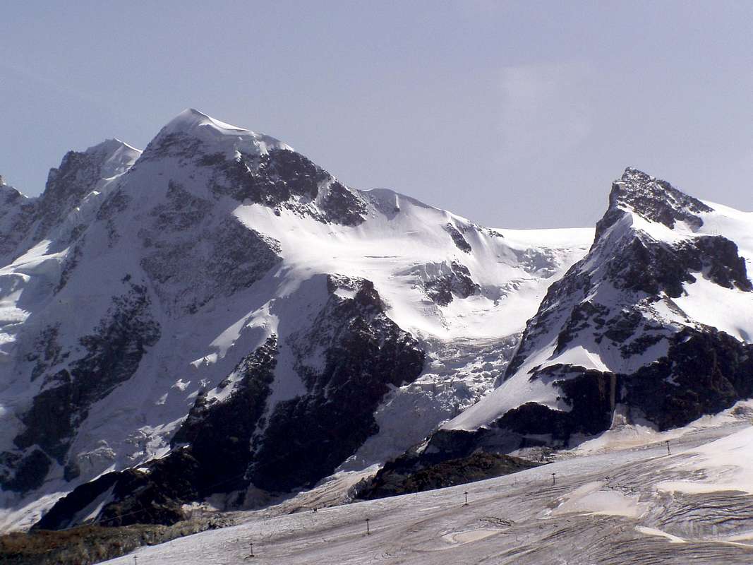
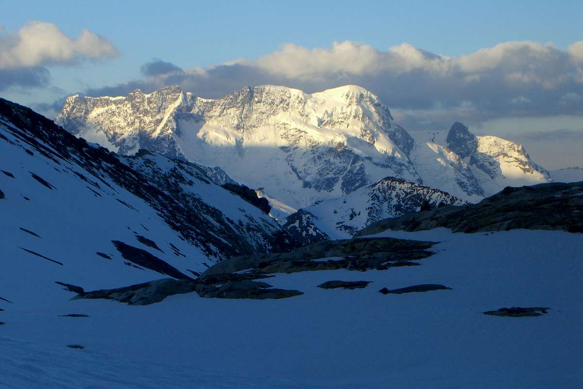
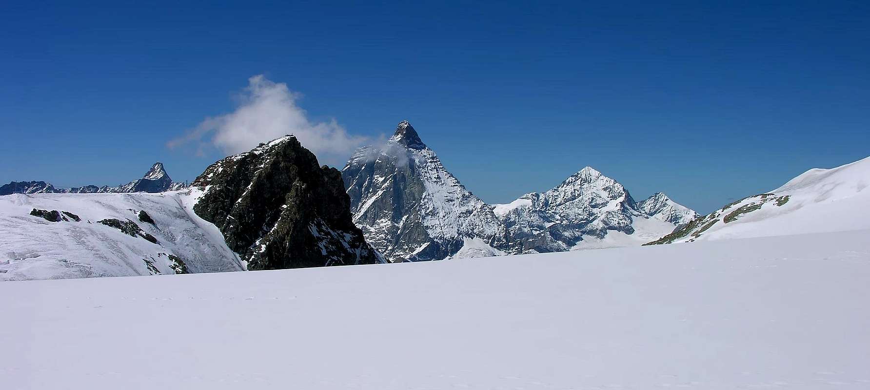
With East-norththwestern View: Breithorns & Klein Matterhorn, by yxygan.
Comunque, partendo dal Rifugio del Teodulo, può soddisfare tramite una salita per gli itinerari di cui sopra, tali da offrire brevi arrapicate abbastanza remunerative e tali da giustificare il soggiorno in un rifugio. Altrimenti, l'esistenza della Funivia di Plan Maison vanifica questo scopo riducendo la gita a percorso da effettuare in giornata. Interessante il "tour" glaciale in senso antiorario che prevede la salita della Gobba di Rollin, i Breithorns per concludersi con il Piccolo Cervino, come appena sopra esplicitato. Purtroppo la montagna é stata deturpata da tutta una serie di infrastrutture per lo sci, che la avvolgono sia a Settentrione sul versante Elvetico che a Mezzogiorno verso l’Italia, ma pur sempre in pieno territorio svizzero, perché la cresta spartiacque che proviene dal Cervino passa per la Testa Grigia e continua verso la Gobba di Rollin (3.902 m) per poi, attraversando il Breithornplateau verso Nordest, scendere e risalire in direzione del Breithorn Occidentale (4.165 m), dove ritorna ad essere più nettamente marcata. Tutta questa area è costellata da impianti di risalita con varii ski lift che si collegano tra di loro, mentre una grande Funivia, omologa di quella che da Breuil-Cervinia sale a Plan Maison ed alla Testa Grigia, sale con un primo troncone da Zermatt fino al Furgg (2.432 m) e da questo al Trockener Steg (2.895 m); un ultimo tratto, passando nei pressi della Gandegghutte, attraversa l'Unterer Theodulgletscher per infine, con un grande "volo aereo" infilarsi nel ventre Settentrionale del Klein Matterhorn, subito sotto la Vetta, uscendone poi a Sud con un altro imbocco. La zona risulta quindi alquanto frequentata dalle masse ma, a poco a poco che, ruotando da Sud a Nord e poi a Nordest verso il selvaggio Ghiacciaio del Kleinmatterhorngletscher, situato tra il Piccolo Cervino ed Il Breithorn Ovest, si percepisce ancora il rude odore di selvaggio che la Natura sa sempre esprimere, al dispetto dell'uomo.
OSSERVAZIONI & NOTE STORICHE
La sua prima salita é facente parte degli albori della nascita dell'Alpinismo ed é datata Agosto del 1792 da parte del Naturalista di Ginevra Horace Bénedict De Saussure, con le sue sette guide svizzere; come per il non molto lontano Mont Velan, salito sette anni dopo dal Naturalista-Monaco dell'Ospizio del Gran San Bernardo Laurent-Joseph Murith con il Cacciatore Genoud, costituisce quella fase primordiale di esplorazione scientifica delle Alpi, tale da aprire la porta alla successiva di conquista delle vette più celebri; e così "capitolarono", in successione, il Breithorn Occidentale (Agosto 1813), la Punta Zumstein (Agosto 1819), la Punta Gnifetti (Agosto 1842), la Dufourspitze, vetta massima della Catena del Monte Rosa (Agosto 1855), il Grand Combin de Grafeneire (Luglio 1859), la Punta Nordend (Agosto 1861), i Lyskamms Orientale (Agosto 1861) ed Occidentale (Agosto 1864), la Dent d'Hèrens (Agosto 1863) in un crescendo tale da costituire il preludio alla grande conquista del 14 Luglio 1865 con la salita della "Gran Becca" o meglio Cervino, conosciuto nel mondo come Matterhorn. Questa fu il termine della congiunzione di due epoche: quella della fase esplorativa, alla quale appartiene il Klein Matterhorn, e quella della fase di conquista delle più belle ed alte vette delle Alpi Pennine, in specifico. Più in là nel tempo si svilupperà anche l'Alpinismo Invernale e, per registrare la salita del "nostro", si dovrà attendere il Gennaio del 1889, protagonisti ancora tre alpinisti elvetici.
Effettueremo una breve, dettagliata ma sintetica descrizione di tutte le vie per il monte esistenti, partendo dal Versante Sud-sudovest o Via Normale che si svolge sui facili pendii del Breithorn con il suo Plateau e, ruotando in senso orario, analizzeremo le partenze che avvengono dai Ghiacciai del Plateau Rosa, de Saint Théodule e dal Kleinmatterhorngletscher. Ottimo belvedere di alta quota con grandi viste sulle Pareti Sud ed Est del vicino Cervino, nonché su tutti i "colossi" del Vallese.
MONTE ROSA BASIN
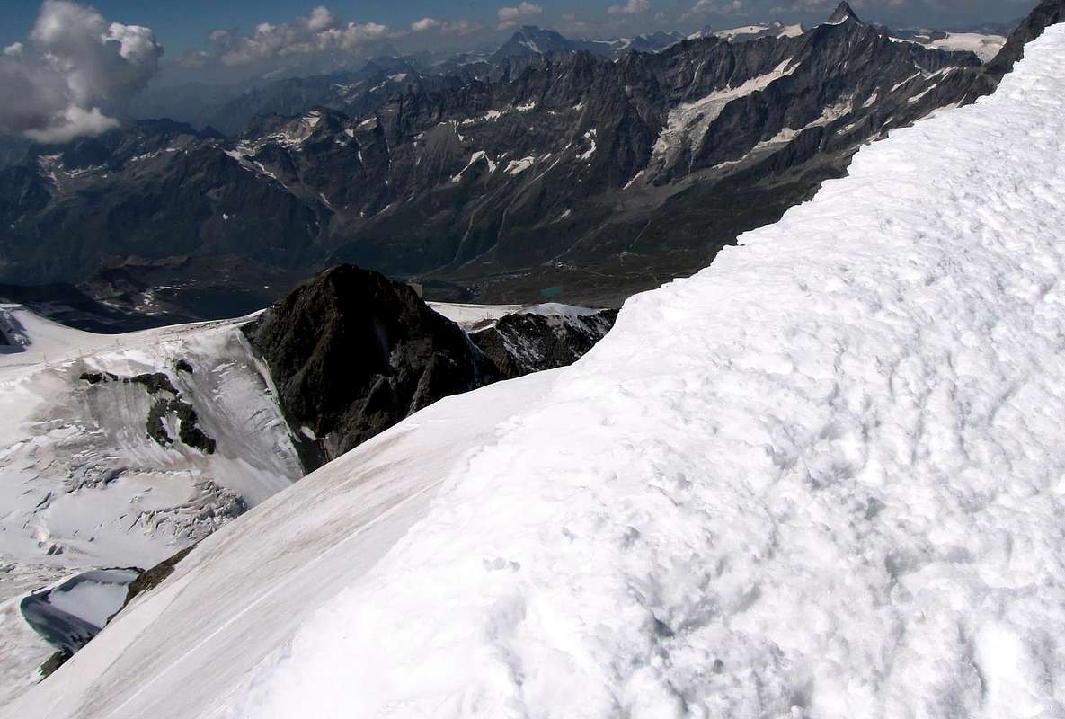
Northerner "Vue d'ensemle" from of Saint Théodule & Unterer Theodulgletscher & Kleinmatterhorngletscher: Klein Matterhorn, three Breithorns & Roccia Nera also Schwarzruken with Schwarztor , Pollux & Castor, Western & Eastern Lyskamms, Balmenhorn or Christ of the Summits, Schwarzhorn also Corno Nero, Ludwigshohe, Parrot & Dufour (3634m, the most elevated of the whole Mount Rosa Chain) and Nordend Points; the last with the of "Santa Caterina Ridge" to outline left,
by KoenVl.
Getting There
BY CAR:
From Torino, Milano, etc: Motorway A5. Exit at Chatillon.
SPECIFIC MAIN ROUTE to BREUIL/CERVINIA
From the exit of the motorway of Chatillon to continue on the SR406 along the Valtournenche Valley, after having overcome the Countries of Antey Saint André (1.074/5m); important deviations of the road to Torgnon Municipality in West ad in East to La Magdeleine Touristic Resort), Buisson (1.124m; Camping Cervino in surroundings; parking and Cableway to Chamois Resort;), Ussin-Saint Michel small Villages (1.305m, 1.289m), Maen's Loch (1.306m; Camping Glair), Maen, Maisonasse, Valtournanche(1.528m), Lake Blue, Breuil/Cervinia is reached (2.006m), where almost to center of the country it is situated the "Funivia" or Cableway (with ample parking lot in quota 2.037 meters), that reaches Plan Maison (2.548m) and to Testa Grigia nearby the Plateau Rosà (3.480m) and at Breithornplateau, from where the itinerary begins.
STRADA REGIONALE SPECIFICA per il BREUIL/CERVINIA
Dall'uscita del casello autostradale di Chatillon proseguire sulla SR406 lungo la Valtournenche, dopo aver superato i Paesi di Antey Saint André (1.074/5 m; importanti deviazioni stradali per Torgnon ad Occidente e per La Magdeleine ad Est), Buisson (1.124 m; Camping Cervino nei pressi; parking e Funivia per il Centro Turistico di Chamois), villaggetti di Ussin-Saint Michel (1.305 m, 1.289 m), Lago di Maen (1.306 m; Camping Glair), Maen, Maisonasse, Valtournanche(1.528 m), Lac Bleu si raggiunge Breuil Cervinia (2.006 m), dove quasi al centro del paese è situata la funivia (con ampio parcheggio a quota 2.037 metri), che porta a Plan Maison (2.548 m) e alla Testa Grigia al Plateau Rosà (3.480 m) ed al Breithornplateau, da dove inizia l'itinerario.
From Switzerland: through the Grand Saint Bernard Tunnel or the with same name pass and from Aosta's Town to Chatillon's Town by the Motorway A5 or through the Main National Route n°26.
From France: through Mont Blanc Tunnel or Petit Saint Bernard Passm through the respectively Main Roads to Morgex and Floor Valley. It isn't necessary to take Motorway A5, near Morgex's Town: you can drive on SS.26, in the direction of Aosta.
BY PLANE:
Aeroporto "Corrado Gex" Saint Christophe (Aosta).
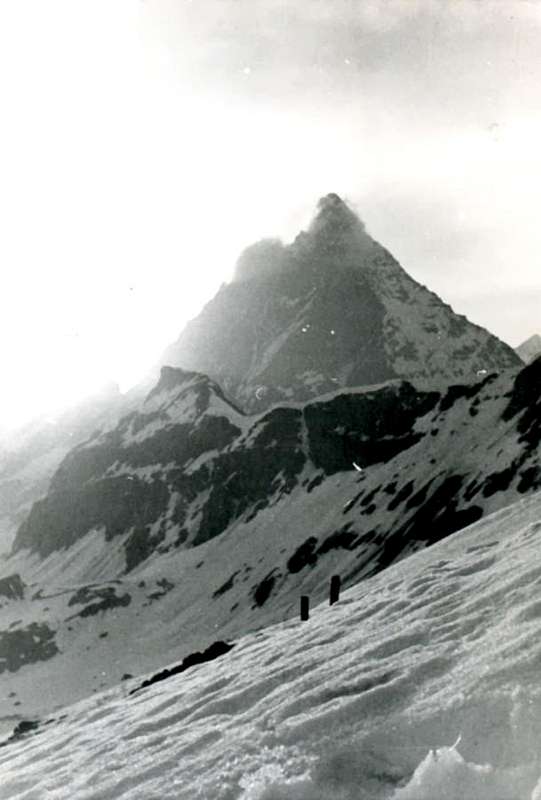
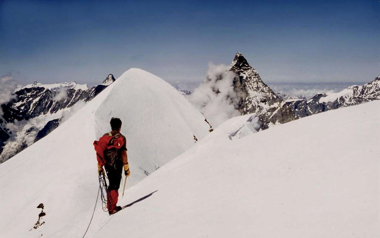
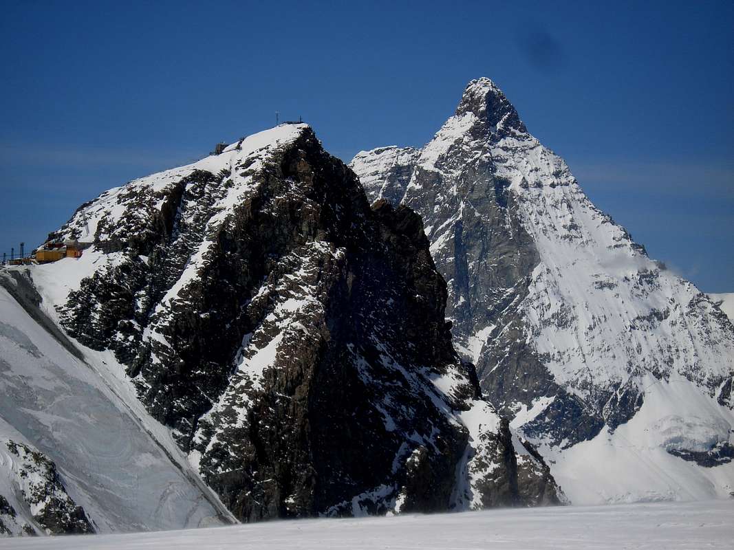
The Old & Ancient Matterhorn seen from the Young & Little Cervino, on Jun 1967, by Gianni Junod.
First Ascents
First on the Summit (through S-SW Slope or Standard Route): Bénedict Horace De Saussure and Mountain Guides J. M. Couttet, J. B. Erin and other five mountain guides; (Aug 13th, 1892).
In winter: H. Biehly, R. Helbling and F. Wagner; (Jan 06th, 1889).
W Face (Direct Route):
Gilberto Carnevali and Franco Goglio; (Dec, 08th, 1953). * First Replay: a group of roped climbers of the C.A.I., Aosta's Section; (Jun 25th, 1967).
W Face: A. Carpignano, N. Cottalorda and R. Montaldo; (Aug 17th, 1971).
W Slope and NW Crest: F. T. Wetheredg and Zermatt's Mountain Guides J. M. Biner and J. J. Truffer; (Jul 29th, 1877).
With west-southwestern View left/right: Northwest Crest, West Face and Northwest Edge or English Route, New Route 1967 on West Face and, to right or South, the Standard Route,by Gianni Junod.
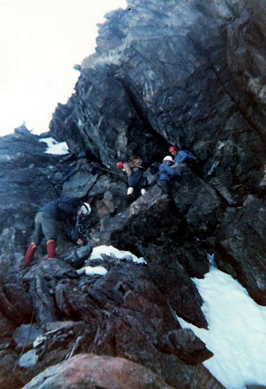
S-SW Wall of rocky Great Shoulder and NW Arete in final part: Ilario Antonio Garzotto, Fracasso Dino and Genola Piero (Guides), Faggion E (Carrier), Giuseppe Polo, Vittorio Manella, Giovanni De Paoli, Gianni Bortolotti, Vanni Florio, Gianni Junod, Tullio Omezzoli, Renato Faval; (Jun 25th, 1967). * * Surely: the rope, conducted by Garzotto and the Guides with, perhaps, some other mountain climbers among the twelve listed in his Diary of Mountain, because in the same trip three diversified itineraries (this Route, Direct "Via" on West Face and West Slope e N-NW Crest also "English Route") were crossed (you see Alpine Diary 1964-69 by Ilario Antonio Garzotto and photo B&W, traced by Gianni Junod).
W Arête: Berthie Neuhaus and Mountain Guides Oskar Supersaxo and Ambros Supersaxo, (Jul 27th, 1904).
N Wall: Oskar Eckenstein and Wunderlick; (Summer 1879). Little Northern Gully: Rolando Albertini and Cesare Roberto; (Aug 04th, 1973).
NE Wall: Gino Gandolfo and Valtournenche Mountain Guide Bruno Bich, (Jul 28th, 1948).
E-NE Face: Vittorio De Tuoni and Mountain Guide of Valtournenche Mario Barmasse; (Dec. 07th, 1986).
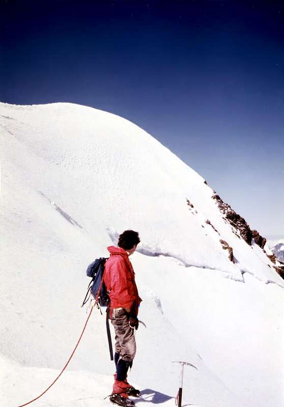
Great Tour Gobba di Rollin-Breithorn West-Central-West-Klein Matterhorn-Testa Grigia: Osvaldo Cardellina, Eugenia Comé, Marco Cossard, Camillo Roberto Ferronato, Giuseppe Lamazzi, Sandro Plat and Raffaella Pellizzari; (Aug 10th, 1980. * Replay: Osvaldo Cardellina, Christian Cardellina, Imperial Eusèbe and return with Robert Chester; (Aug 06th, 1986).
The Route RECOMMENDED
GREAT TOUR of Breithornplateau: from Testa Grigia (3.480m), through the Gobba of Rollin (3.902m) & Breithornpass (3.818m) to West Breithorn.
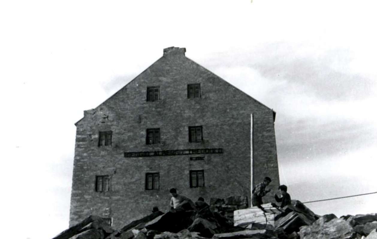
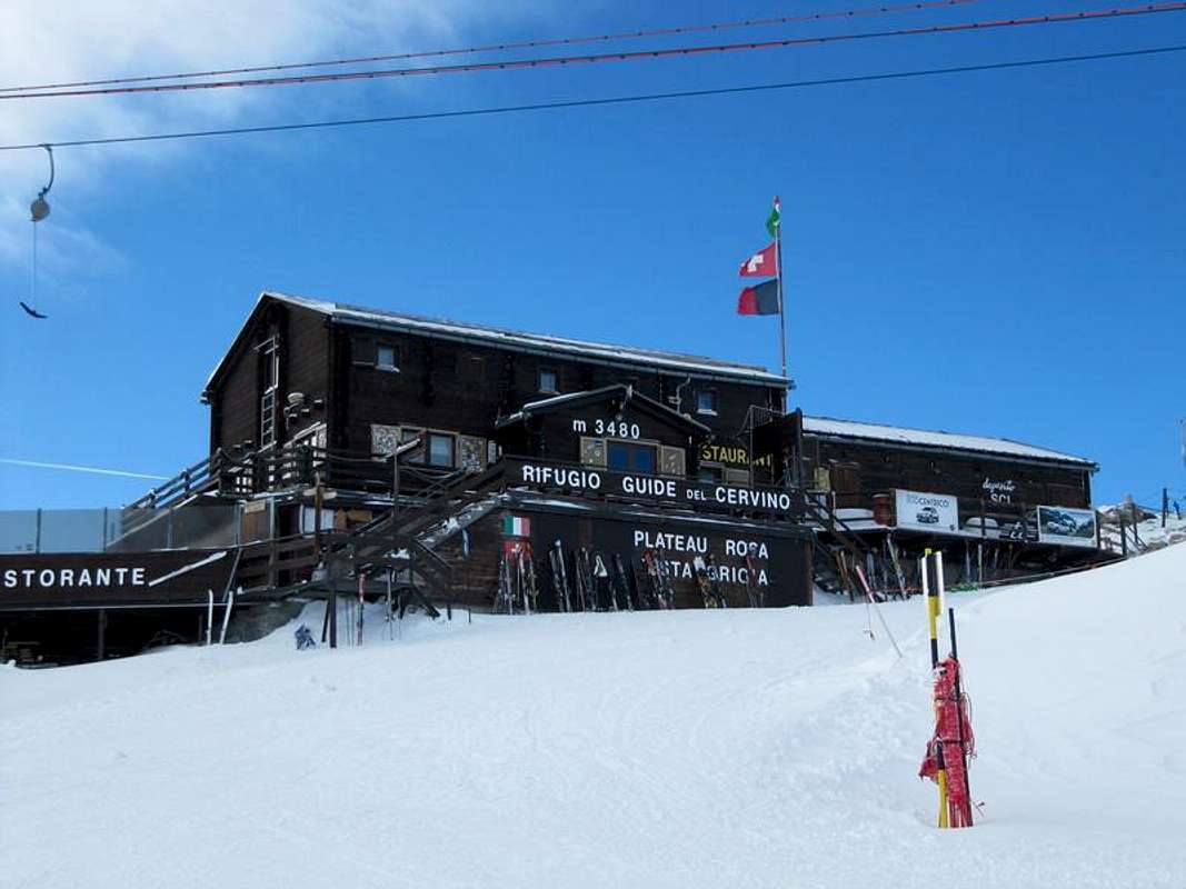
Before describing in systematic and classical way from the right to the left, or clockwise all the specific routes to the slope of the Klein Matterhorn , a recommended trip proposes him and such to allow to cross and to know the whole Basin of the Breithornplateau , with progressive ascension from the arrival of the "Funivia" to the Grey Head also Testa Grigia (3.480m; Shelter Guides of the Cervino) and from the neighbor Pass Septentrional of Aventine or Ventina (3.450m). From this last to almost integrally follow the crest of border Italian/Swiss, with by a few different from the Standard one of the Gobba of Rollin (3.902m). Old, or edged on the left (North), a first rocky band to quota 3.594 meters to continue on the crest watershed, here not very evident, reaching the following Hill Meridional of Aventine (3.690/700 meters around), sets among the North Breithornplateau and the Glacier of Midday Aventine. Reached the point of arrival of the Chair lift, that from the Plateau Rosa reaches on the crest quota 3.735 meters , and brusquely changing Southeast direction in East, to pass below the stump that immediately unites the arrival of the same one with that coming from the quota 3.809 meters to South of the Peak of the Little Cervino reaching really on Top of the Hump of Rollin. You crosses a long snowy tableland in plain forgery and him over it passes, finally, a small snowy hump to quota 3.852 meters, easily reaching the same one. From the come down Summit, through the Slope Northeast and climbed over the meaningless quota 3.854 meters , to the Breithornpass (3.818m); from this always on the border (a few virtual) of frontier to continue, same direction, along the Breithornplateau rejoining himself to the Normal Route for the scaling of the West Breithorn (4.165m); from this double crossing to the Central Breithorn (4.156m) through the small Saddle 4.075 meters . Then come down by the Breithorn "Occidentale", same "street", and gone up again terminal to the Klein Matterhorn (3.881m), through his Normal Route or Slope South-southwest, as well as, in last, come down by the same one with return to the point of departure to the Testa Grigia crossing, this time, the Northeast glacier toward Southwest (F+; 6h'30/7h'30; attention to calculate well, effecting the tour in day, the times of route of the various tappes in relationship to the last descent of the Cableway of Plan Maison, because the descent to the Breuil/Cervinia is long and weary (for personal experience); the closing of the same one generally happens among the hours 17'00 and 17'30, to inquire, IMMEDIATELY, himself to the morning before the run of slope.
***
GREAT TOUR of Breithornplateau: towards Westerner & Eastern Summit Round Trip among the Little Saddle 4.075m, by Ilario Antonio Garzotto, Camillo Roberto Ferronato & Osw.
Prima di descrivere in modo sistematico e classico dalla destra alla sinistra, ovvero in senso orario tutte le vie specifiche alla salita del Klein Matterhorn, si propone una gita consigliata e tale da permettere di percorrere e conoscere tutto il Bacino del Breithornplateau, con ascensione progressiva dall'arrivo della Funivia alla Testa Grigia (3.480 m; Rifugio Guide del Cervino) e dal viciniore Col Septentrional d'Aventine o di Ventina(3.450 m). Da questo ultimo seguire quasi integralmente la cresta di confine italo/svizzera, con via leggermente diversa dalla Normale della Gobba di Rollin (3.092 m). Superata, o contornata sulla sinistra (Nord), una prima fascia rocciosa a quota 3.594 m) proseguire sulla cresta spartiacque, qui non molto evidente, raggiungendo il successivo Col Meridional d'Aventine (3.690/700 metri circa), posto tra il Breithornplateau a Nord ed il Glacier d'Aventine a Mezzogiorno. Raggiunto il punto d'arrivo della Seggiovia, che dal Plateau Rosa perviene sulla cresta a quota 3.735 metri, e cambiando bruscamente direzione da Sudest in Est, passare al di sotto del troncone che unisce l'arrivo della medesima con quello proveniente dalla quota 3.809 metri subito a Sud della Vetta del Piccolo Cervino giungendo proprio in Cima alla Gobba di Rollin. Si percorre un lungo pianoro nevoso-glaciale in falso piano e si oltre passa, infine, una piccola gobba nevosa a quota 3.852 metri raggiungendo facilmente la stessa. Dalla Sommità discesa, tramite il Versante Nordest e scavalcata la insignificante quota 3.854 metri, al Breithornpass (3.818 m); da questo sempre sul confine (un pochino virtuale) di frontiera proseguire, stessa direzione, lungo il Breithornplateau ricongiungendosi alla Via Normale per la scalata del Breithorn Ovest (4.165 m); da questo doppia traversata al Breithorn Centrale (4.156 m) per mezzo della piccola Sella 4.075 metri. Quindi discesa dal Breithorn Occidentale, stessa via, e risalita terminale al Klein Matterhorn (3.881 m), per mezzo della sua Via Normale o Versante Sud-sudovest, nonché, da ultimo, discesa dal medesimo con ritorno al punto di partenza alla Testa Grigia attraversando, questa volta, il ghiacciaio da Nordest verso Sudovest (F+; 6h'30/7h'30; attenzione a calcolar bene, effettuando il tour in giornata, i tempi di percorrenza delle varie tappe in rapporto all'ultima discesa della Funivia di Plan Maison, perché la discesa al Breuil/Cervinia é lunga ed estenuante (per esperienza personale); generalmente la chiusura della medesima avviene tra le ore 17'00 e 17'30, informarsi, SUBITO, al mattino prima della corsa di salita).
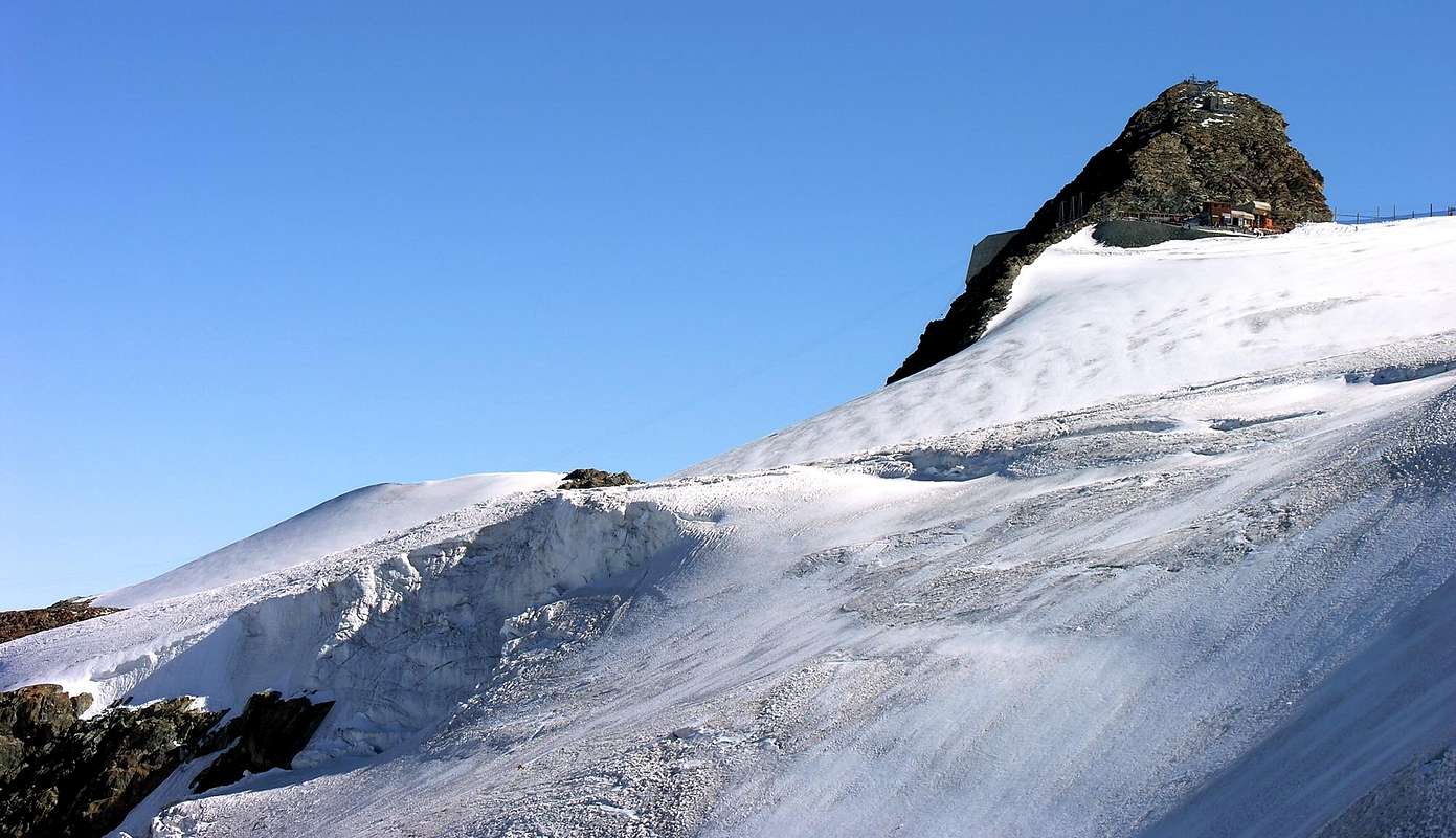
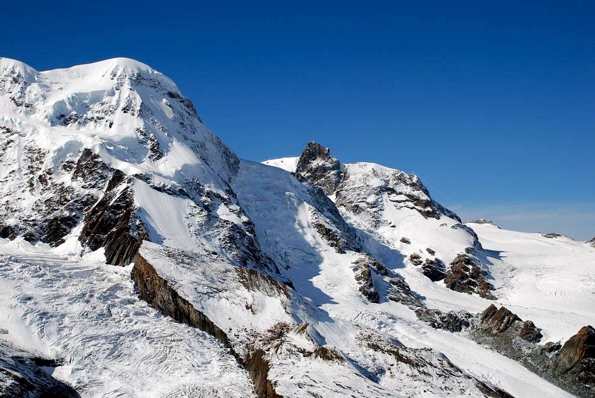
And, finally, to KLEIN MATTERHORN & Testa Grigia from Standard Route of Western Breithorn (4.165m), with Northeastern View, by Antonio Giani.
All Other Routes Description
KLEIN MATTERHORN from Western Breithorn (4.165m) with Northeastern View, by Antonio Giani.
Routes Clockwise Order Description
ROUTE A) - Normal Route from the Breithorn Pass and S-SW Slope: it is the route of the first mountaineers from the famous Naturalist of Geneva Horace Bénedict De Saussure with the Guides J.M. Couttet, J.B. Errin and other five Swiss Guides; through the same one the first absolute ascension of the mountain happened in also the January 1889, always by three Swiss mountaineers (you see "Saussure IV", page 415; "Uber Eis und Schnee" of Gottlieb Studer to Drink 1876 of them, to the pages 300/1; "Echo des Alpes 1882", pag. 48, "Jahrbuch des Schweizer Alpen Club" (since 1864 until 1923) SAC LII", pag. 66, "Guides des Alpes Valaisannes 1922" by Henri Dubi, pag. 8 and "Guides des Alpes Valaisannes 1930" to work by Marcel Kurz, pag. 80 with toponomastic notes of Léon Meyer). From the "Testa Grigia" (3.480m; Guides of Matterhorn Refuge); from and along the Glacier of the Plateu Rosà to address him to East on numerous traces toward the Breithorpass or Hill of the Breithorn (3.818m), of few to North of the Gobba di Rollin (= Hump of Rollin; 3.902m). From the Pass (500 meters around before) to turn to Northern and to cover Plateau Rosà Glacier towards the Saddle (3.796m) and trough the same (South-southwest) easily to reach the Summit climbing elementary little and rotten rocks (falling rocks for transit numerous mountaineers; 0h'45; 1h'20 from Plain Maison Superior Station).
VIA A) -Via Normale dal Colle del Breithorn e tramite il Versante S-SO: é la via dei primi salitori da parte del celebre Naturalista ginevrino Horace Bénedict De Saussure con le Guide J.M. Couttet, J.B. Errin ed altre cinque Guide svizzere; tramite la stessa avvenne anche la prima ascensione assoluta della montagna nel Gennaio 1889, sempre da parte di una cordata svizzera composta da tre alpinisti (vedi "Saussure IV", pagina 415, "Uber Eis und Schnee" di Gottlieb Studer Berne 1876, alle pagine 300/1, "Echo des Alpes 1882", pag. 48, "Jahrbuch des Schweizer Alpen Club" (dal 1864 al 1923) SAC LII", pag. 66, "Guide des Alpes Valaisannes 1922" di Henri Dubi, pag. 8 e "Guide des Alpes Valaisannes 1930" ad opera di Marcel Kurz, pag. 80 con note toponomastiche di Léon Meyer). Dalla Testa Grigia (3.480 m; Rifugio Guide del Cervino); dal e tramite il ghiacciaio del Plateau Rosà indirizzarsi ad Est su numerose tracce verso il Breithornpass o Colle del Breithorn (3.818 m), di poco a Settentrione della Gobba di Rollin (3.902 m). Dal Colle (500 metri~ prima) volgere a Settentrione e percorrere il Ghiacciaio del Plateau Rosà verso la Sella (3.796 m) e per la facile "groppa" Sud-sudovest raggiungere la vetta con qualche roccetta elementare e frantumata (caduta sassi per transito di alpinisti; 0h'45; 1h'20 dalla Stazione Superiore di Plain Maison).
KLEIN MATTERHORN from Ventina's Glacier with Southeastern View to South Slope or Normal Route, by Antonio Giani.
ROUTE B) - West Face Direct Route: the wide Western Wall of the Klein Matterhorn is unfolded by the left with the great Crest North-northwest "losing itself" gradually in the sweetest slant toward South-southwest, long which passes the Normal Route of slope to the mountain, to go to melt himself with the junction among the Plateau Rosa and the impending Glacier of the Breithorn or Breithornplateau. Ploughed in the mean of his wide triangular form by a glacial slant, that slips departing around from quota 3.700 meters about to the 3.400 meters around, where it is dissolved against the underlying fall of the seracs of the Plateau Rosa, introduces in his superior part a small rocky wall, tall few less than 200 meters, that what triangular, but more narrow cusp always and generally ploughed longitudinally by a frozen oblique little gully, it finishes in Peak. Through the approach common to the "Street of the English" or Route D)- in the median part of the Face, and where this mostly turns to Northeast to go himself in crest, and through this final rocky part has been traced a route from Gilberto Carnevali and Franco Goglio the 8 December of 1953, opening a Direct Route on the West Slope. To such intention you see "Alpes Valaisannes. Du Theodulpass au Mountain Moor, vol. III." Guide of the CAS or Swiss Club Alpino; Edit. in 1978 and besides Guide of the C.A.I. or Club Alpino Italian and T.C.I. or Italian Touring Club "Monte Rosa", to work of Gino Buscaini; Edit. 1991, to the page 167 with itinerary "9b) from West (by direct)." The same route should be Jun 25 th, 1967 been repeated by a rope of the Section of the C.A.I. of Aosta, as it is clearly deduced by the tracing personally effected by Gianni Junod in the photo, in black and white that it appears in this job (you see First Ascents); he is not given by to know, actually and at present, from what of the twelve mountain climbers present in some trip (always in listed First all together with intention of the traced New Variant or Route E)- ) that, probably separated in different ropes, they effected three well separate runs: one with the Garzotto and the Guides on the Variant New, one along the traditional one "English's Route" and the third one directly along the final West Wall, as drawn in the photo. From the "balcony-terraces" glacial to go himself thin against the final rocky wall and to cross it long his small central channel, or supporting himself on his flanks (probably AD and, more or less, with the same time of the "Route of the English" or Route E)-; itinerary exposed to fall of stones, for which the same considerations are worth effected speaking of the Route L)- or you seem East-northeast Wall).
VIA B) -Via Diretta sulla Faccia Ovest: la larga Parete Occidentale del Klein Matterhorn si dispiega dalla sinistra con la grande Cresta Nord-nordovest "perdendosi" gradualmente nei pendii più dolci verso Sud-sudovest, lungo i quali passa la Via Normale di salita alla montagna, per andare a fondersi con la giunzione tra il Plateau Rosa ed il soprastante Ghiacciaio del Breithorn o Breithornplateau. Solcata nel mezzo della sua estesa forma triangolare da un pendio glaciale, che scivola partendo da quota 3.700 metri circa ai 3.400 metri circa, dove si stempera contro la sottostante seraccata del Plateau Rosa, presenta nella sua parte superiore una piccola parete rocciosa, alta poco meno di 200 metri, che quale cuspide sempre triangolare, ma più ristretta e solcata longitudinalmente da un in genere ghiacciato canalino obliquo, termina in Vetta. Tramite l'avvicinamento comune alla "Via degli Inglesi" o Route D)- nella parte mediana della Faccia, e dove questa volge maggiormente a Nordest per portarsi in cresta, e per mezzo di questa parte rocciosa finale, è stata tracciata una via da parte di Gilberto Carnevali e Franco Goglio l'8 Dicembre del 1953, aprendo una via diretta sul Versante Ovest. A tale proposito vedi "Alpes Valaisannes. Du Theodulpass au Monte Moro, vol. III". Guida del C.A.S. o Club Alpino Svizzero; Edit. nel 1978 ed inoltre Guida del C.A.I. O Club Alpino Italiano e T.C.I. ovvero Touring Club Italiano "Monte Rosa", ad opera di Gino Buscaini; Edit. 1991, alla pagina 167 con itinerario "9b) da Ovest (via diretta)". La stressa via dovrebbe essere stata ripetuta il 25 Giugno 1967 da una cordata della Sezione del C.A.I. DI Aosta, come si evince chiaramente dalla tracciatura effettuata personalmente da Gianni Junod nella foto in bianco e nero, che appare in questo lavoro (vedi First Ascents); non è dato da sapere, effettivamente ad oggi, da parte di quali dei dodici alpinisti facenti parte della gita (sempre in First elencati tutti insieme a proposito della Nuova Variante tracciata o Route E)-) che, probabilmente divisi in diverse cordate, effettuarono tre percorsi ben distinti: uno con il Garzotto e le Guide sulla Nuova Variante, uno lungo la tradizionale "Via degli Inglesi" ed il terzo direttamente lungo la Parete Ovest finale, come disegnato nella fotografia. Dai "terrazzamenti" glaciali portarsi sin contro la parete rocciosa finale e percorrerla lungo il suo canalino centrale, oppure appoggiandosi sulle sue sponde (probabilmente AD e, più o meno, con lo stesso tempo della "Via Inglese" o Route D)- ; itinerario esposto a caduta di pietre, per il quale valgono le stesse considerazioni effettuate a proposito della Route L)- o Parete Est-nordest).
ROUTE C) - West Face: eighteen years later, precisely on August 17 (you/he should not be gone to mountain because for the tradition-superstition alpine door badly) of 1971, a new route has been traced from the mountain climbers A. Carpignano, N. Cottalorda and R. Montaldo; the same one overcomes the part most Northern of the small terminal wall and it goes up again it along an evident spur with a gradient of around 180/90 meters from the term of the glacial slant to the Peak. Surely introduces technical characteristics of more elevated difficulty in comparison to the preceding route and enough good and compact rock happens; through itinerary probably not yet repeated and surely, developing itself in crest, surer than the preceding one by along the "canalino" or icy small gully; (see RM of the C.A.I. 1973 page 120 and "Guida del Monte Rosa" by Gino Buscaini; Edit. 1991 page 167 with itinerary "9c) from West.). To attach as soon as to the left of the preceding Route B) - bringing himself against the second spur departing from the left or North; to go up again the first 120/30 metres with climb enough difficult (III°/III°+) reaching well a carving in sight. Same give to continue on the thread of crest for other 60 meters around reaching to a minuscule snowfield (III°/IV° with a brief passage of V°); from this always supporting on the left, shortly, the Crest is reached North-northwest, here which Edge Northwest) with which easily the Top is reached (from AD+ to D -; 2h'00/2h'30 from the base of the Plateau Rosa; in total 4h'00 from the Shelter of the Teodulo, time employed in the first ascension).
VIA C) -Faccia Ovest:diciotto anni dopo, precisamente il 17 Agosto (non si dovrebbe andare in montagna perché per la tradizione-superstizione alpinistica porta male) del 1971, é stata tracciata una nuova via da parte degli alpinisti A. Carpignano, N. Cottalorda con R. Montaldo; la stessa supera la parte più Settentrionale della piccola parete terminale e la risale lungo un evidente sperone con un dislivello di circa 180/90 metri dal termine del pendio glaciale alla Vetta. Presenta caratteristiche tecniche di difficoltà sicuramente più elevate rispetto alla precedente via ed avviene per mezzo di roccia abbastanza buona e compatta; itinerario probabilmente non ancora ripetuto e sicuramente, svolgendosi in cresta, più sicuro della precedente via lungo il canalino; (vedi RM del C.A.I. 1973 alla pagina 120 e "Guida del Monte Rosa" di Gino Buscaini; Edit. 1991 pagina 167 con itinerario "9c) da Ovest.). Attaccare appena a sinistra della precedente Route B)- portandosi contro il secondo sperone partendo dalla sinistra o Nord; risalire i primi 120/30 metri circa con arrampicata abbastanza difficile (III°/III°+) raggiungendo un intaglio bene in vista. Dallo stesso proseguire sul filo di cresta per altri 60 metri circa pervenendo ad un minuscolo nevaio (III°/IV° con un breve passaggio di V°); da questo appoggiando sempre sulla sinistra, in breve, si raggiunge la Cresta Nord-nordovest, qui più quale Spigolo Nordovest) con la quale facilmente si raggiunge la Cima (da AD+ a D-; 2h'00/2h'30 dalla base del Plateau Rosa; in totale 4h'00 dal Rifugio del Teodulo, tempo impiegato nella prima ascensione).
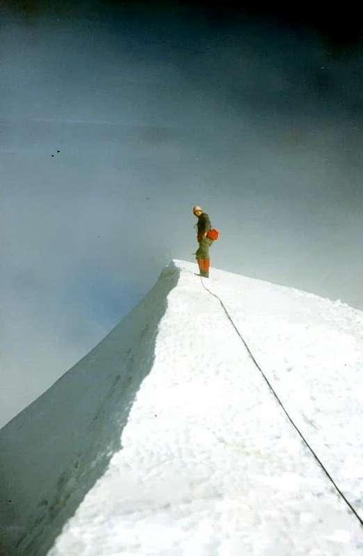
Gianni Junod on Summit of Piccolo Cervino, after the N-NW Crest or through the "English Route", on Jun 25th, 1967, by Ilario Antonio Garzotto.
ROUTE D) - West Slope and Ridge/Edge N-NW, said "English Route": from the Shelter of the Teodulo (3.316/7m) and the underlying homonym Hill or Saint Théodule, to go at first himself in light descent toward the Glacier de Saint Théodule and then with as many "sweet" climbed in direction of the "Low" Glacier of Plateau Rosa(à) on the route that brings to the Pass of the Breithorn (3.818m); reaches the height around of the Testa Grigia (= Grey Head; 3.480m), and immediately in East of the same one, to abandon this street, as soon as before a first zone with many crevasses and, reversing the direction of Northeast march Southeast, to reach the basal part of the wide West Slope, immediately on the right (South) of a characteristic and long rocky band that, horizontally it originates from the Crest, N-NW. Doubling it on his right whereas it exhausts him against the glacier, to begin to climb, with direction Northeast, the glacial-snowy slant; at first with moderate inclination and increasing, subsequently, progressively the same one (from 30° to 35° and also 40° in the final part), to reach the base of a great vertical and dark great rock, constituent the second rocky band with origin from the crest (New Route of the 1967 Garzotto & Company). To also double this on the right and, with a diagonal oblique from Northeast Southwest, to reach, always with run on snow or ice, with a terminal line of a little steep, on the ridge of crest near the great snowy shoulder to quota 3.762 meters of the CNS (= Paper National Switzerland) or among quota 3.750 meters and the following small saddle 3.742 meters for the Paper R.A.V.A (= Paper of the Autonomous Region of the Valley of Aosta) and in "L'Escursionista Valtournenche Monte Cervino Val d'Ayas ovest n°7"; besides 3.758 meters in "Guide of the Mount Rosa", by Gino Buscaini, Edit. C.A.I. 1991, Pages 167/8. From this shoulder, snow-capped, to continue on the thread of crest that, in the terminal line rocky edge becomes, for alternate easy rocks to brief lines snowy (possibility to find" verglass") easily the Peak is reached (PD/PD+, passages from the I° to the II°/II°+; 1h'45 from the base; in total from the Shelter Teodulo 2h'15/2h'45, according to the conditions both of the glacier that of the final crest).
VARIANT from TESTA GRIGIA
Arriving from the Testa Grigia, reached through the Cableway of Plan Maison-Lakes of Cimes Blanches, to begin with the route along the Glacier of the Plateau Rosa in direction of that of the Breithorn for the slope to this last Top; half Km around before the homonym Hill, to turn toward North going down toward the "Low" Glacier of the Plateau Rosà and, bringing himself at basic the of the West Slope of the Klein Matterhorn, to rejoin him to the precedent itinerary (dark or less the same time, but to pay to lot of attention to the crevasses, here numerous).
Klein Matterhorn N-NW Crest and "English Route", on June 25th, 1967, by Gianni Junod.
VIA D) -Versante Ovest e Cresta/Spigolo N-NO, detta "Via degli Inglesi": dal Rifugio del Teodulo (3.316/7 m) ed il sottostante omonimo Colle, o Saint Théodule, portarsi in leggera discesa dapprima verso il Glacier de Saint Théodule e poi con altrettanto "dolce" salita in direzione del "Basso" Ghiacciaio di Plateau Rosa(à) sulla via che porta al Colle del Breithorn (3.818 m); giunti all'altezza circa della Testa Grigia (3.480 m), e subito ad Oriente della medesima, abbandonare questa via, appena prima di una prima zona alquanto crepacciata ed, invertendo la direzione di marcia da Sudest a Nordest, raggiungere la parte basale del largo Versante Ovest, subito sulla destra (Sud) di una caratteristica e lunga fascia rocciosa che, orizzontalmente, proviene dalla Cresta N-NO cingendo alla base il versante. Doppiandola sulla sua destra laddov'essa si esaurisce contro il ghiacciaio, iniziare a salire, con direzione Nordest, il pendio glacio-nevoso; dapprima con moderata pendenza ed aumentando, in seguito, progressivamente la medesima (da 30° a 35° ed anche 40° nella parte finale), raggiungere la base di un grande roccione verticale e scuro, costituente la seconda fascia rocciosa con provenienza dalla cresta (Via Nuova del 1967 Garzotto & Company). Doppiare anche questo sulla destra e, con un diagonale obliquo da Sudovest a Nordest, pervenire, sempre con percorso su neve o ghiaccio, con un tratto terminale di poco più ripido, sul crinale di cresta presso la grande spalla innevata a quota 3.762 metri della CNS (= Carta Nazionale Svizzera) o tra quota 3.750 metri e la successiva piccola sella 3.742 metri per la Carta R.A.V.A (= Carta della Regione Autonoma della Valle d'Aosta) in "L'Escursionista Valtournenche Monte Cervino Val d'Ayas ovest n° 7"; inoltre 3.758 metri in "Guida del Monte Rosa", di Gino Buscaini, Edit. C.A.I. 1991, pagine 167/8. Da questa spalla, "incappucciata" in neve, proseguire sul filo di cresta che, nel tratto terminale diventa spigolo roccioso, per rocce facili alternate a brevi tratti innevati (possibilità di trovare "verglass") facilmente si raggiunge la Vetta (PD/PD+, passaggi dal I° al II°/II°+; 1h '45 dalla base; in totale dal Rifugio Teodulo 2h'15/2h'45, a seconda delle condizioni sia del ghiacciaio che della cresta finale).
VARIANTE dalla TESTA GRIGIA
Arrivando dalla Testa Grigia, raggiunta tramite la Funivia di Plan Maison-Laghi delle Cime Bianche, iniziare con la via lungo il Ghiacciaio del Plateau Rosa in direzione di quello del Breithorn per la salita a quest'ultima Cima; mezzo Km circa prima dell'omonimo Colle, voltare verso Settentrione scendendo verso il "Basso" Ghiacciaio del Plateau Rosà e, portandosi alla base del Versante Ovest del Klein Matterhorn, ricongiurgersi al precedente itinerario (più o meno lo stesso tempo, ma prestare molta attenzione ai crepacci, qui numerosi).
ROUTE E) - S-SW Wall of rocky Great Shoulder and NW Arete in terminal part: from the Alpine Diary 1964-1969 of Ilario Anthony Garzotto: ... "KLEIN MATTERHORN CREST N. O. WITH VARIANT (3.880 m) 24 - 25 June 1967 Fracasso Dino and Genola Piero (guides), Faggion E (carrier), Polo Giuseppe, Manella Vittorio, De Paoli Giovanni, Bortolotti Gianni, Florio Vanni, Junod Gianni, Omezzoli Tullio, Faval Renato and Garzotto Antonio. We depart from the Ref. of the Teodulo to the to integrally climb the crest, directs 5.00-instead there toward a group of rocks that you/they directly climb to the great shoulder of the crest, allowing us to avoid the snow it releases been very abundant. Said rocks they form a great well visible couloir from the PLATEAU - ROSA: we follow really this. A long fireplace with "verglass" is the first obstacle. They follow some plates of friable rock, a line of 4-5 meters overhanging (4°) they follow again other easy rocks and a line impending followed by a dihedral of 10-15 meters. frozen (the judgment of the guides: 4° sup.) what I overcome for first. We are on the shoulder. Brief standstill and we start over climbing. The real crest is not difficult - A. the 10.00 is in peak and at 12.00 o'clock to the shelter - The time is enough good." ...(3h'30 from the base; 5h'00 altogether from the Théodule Refuge; the "via" doesn't result to have been repeated and is to consider, as expressed in the Alpine Diary, an extemporaneous variation so that to avoid the tall snow and not yet transformed of beginning season).
TWO or THREE? DIFFERENT ROUTES in the same day for Ilario Antonio Garzotto and Gianni Junod; on Summit of Klein Matterhorn also Piccolo Cervino, in Jun 25th, 1967, by Gianni Junod & Ilario Antonio Garzotto.
VIA E) -Parete S-SO dello Spallone roccioso e Cresta NO nel finale:dal Diario Alpinistico 1964-1969 di Ilario Antonio Garzotto: ... "KLEIN MATTERHORN CRESTA N. O. CON VARIANTE (3.880 m) 24 - 25 giugno 1967 Fracasso Dino e Genola Piero (guide), Faggion E (portatore), Polo Giuseppe, Manella Vittorio, De Paoli Giovanni, Bortolotti Gianni, Florio Vanni, Junod Gianni, Omezzoli Tullio, Faval Renato e Garzotto Antonio. Partiamo dal Rif. del Teodulo alle 5.00 - Invece di salire la cresta integralmente, ci dirigiamo verso un gruppo di roccie che salgono direttamente allo spallone della cresta, permettendoci di evitare la neve molla ancora abbondante. Dette rocce formano un canalone ben visibile dal PLATEAU - ROSA: noi seguiamo proprio questo. Un lungo camino verglassato é il primo ostacolo. Seguono alcune placche di roccia friabile, un tratto di 4 - 5 m strapiombante (4°) seguono altre facili rocce e un tratto di nuovo strapiombante seguito da un diedro di 10 - 15 m ghiacciato (il giudizio delle guide: 4° sup.) che supero per primo. Siamo sulla spalla. Breve sosta e riprendiamo a salire. La cresta vera e propria non é difficile- Alle 10.00 siamo in vetta e alle 12.00 al rifugio- Il tempo é abbastanza buono." ... (3h'30 dalla base; 5h'00 in totale dal Rifugio del Teodulo; la via non risulta ripercorsa ed é da considerarsi, come espresso nel Diario Alpinistico, una variante estemporanea laonde evitare la neve alta e non ancora trasformata di inizio stagione).
ROUTE F) - Classic and Integral NW Arete: beautiful "street" proper of the classical mountaineering of exploration and of discovery proper of another epoch, that takes back the itinerary of July 1887 completing it, with slope from the base of the whole Crest Northwest, that has course North-northwest in reality; in fact, departing from the quota 3.225/30 meters around (slightly more to East 3.244 meters the beginning of the long rocky belt of base is rated, that from Northeast "it races" toward Southwest almost entirely encircling the West Slope of the mountain), where the crest dips him in the Glacier of the Unterer Theodulgletscher, they occur two precise changes of direction. The same goes up again with the first verse, then, mostly folding up to Midday, formed for road the quotas 3.668 meters and the following 3.750 meters, it reaches a small snowy saddle that the Paper of the "The excursionist n°7" quota in 3.742 meters; from this point the great crest assumes more the form of a rocky-snowy edge and, through the second direction or N-NW, it reaches the Peak (as he underlines in profile very well above in the Old B&W, by Gianni Junod with the same one, as well as in the underlying color photos of hansw, where the same one appears in the exact center of the portrait of the mountain, to left). Arriving from the Gandegghutte (3.036 meters on her "Paper R.A.V.A" and 3.229 meters on her "CNS"), as they made the first mountaineers, with brief descent on the path toward the Glacier of the Unterer to reach it to the quota of 2.850 meters around, to cross there it where the same him "throat" meeting with the Glacier de Saint Théodule and originating that some Oberer. From this point to go up again with moderate slant on the glacier immediately placing side by side to West the long rocky buttress that, departing from the shelter, it is fit to separate the two Glaciers of the Unterer (to East-northeast) and of the Oberer (to North-northwest), doubling it on the left and reaching at the end of the same one quota 3.179 meters "to enter" so in the Unterer and to cross contemplating it at the base of the North-northwest Crest, where this melts him with the glacier. To go up again to the right immediately on the glacial slant (West) of to thin rocky line (interesting and rather explicit The Squirt it n°1 to the page 102 of the "Old" Edition 1960 of the Guides of the C.A.I. "Mountain Rosa", by Saglio & Boffa) and with the slant in ice of 30° around to progress around for 70/80 meters up to where the same one him tightens among the aforesaid rocky line and the beginning of the long band basic of that it winds the West Slope. To go himself above this last and, through glacio-snowy slant in progressive increase of inclination, to easily cross the thread of crest; it is reached so a rockier line to the quota 3.668 meters, where the crest sends a second horizontal rocky band toward South, that finishes in the quota 3.685 meters. To abandon it on the right and to keep on climbing bringing himself against a big rocky jump that is overcome on his right (South; II° and II°+), or in the center with more binding difficulty rather; reached the summit (unfortunately the crest results here "contaminated" from pylons) it immediately is reached after the capped and triangular quota snowy 3.750 meters (or you see the considerations to the Route D)-) and, with brief descent the small saddle also it snowy 3.742 meters. With undulated and sinuous run he reaches the final part, where the great crest transforms him in slender Edge North-northwest, mixed of rocks and snow. Him he easily goes up again (I° and II°), but watching out in presence of ice shortly, reaching the Peak (2h'00/2h'30 from the base; 3h'30/4h'30 from the Gandegghutte ; suitable ascension for lovers of aerial slopes and pannings, as well as lacking of objective dangers; itinerary thick run for the just express motives).
VARIANTS of the APPROACH from TESTA GRIGIA or from THE'ODULJOCH
1) - departing from the Shelter of the Teodulo (3.316/7m), near the homonym Hill, to follow the Route A) - for a line a lot of brief, on the junction of the two Glaciers de Saint Théodule and of the Unterer. Leaving, then, this route on the right (Southeast) and with a long diagonal toward Northeast, to cross this last addressing himself at the base of the Crest North-northwest reaching it in his low final part; not to go down completely up to his base, on the contrary "tocut" above of around 70/80 meters and, with run first semicircular toward East and then Southeast, to insert him to the route coming from the Gandegghutte, avoiding so the first line up to the narrow passage between the thin rocky line and the beginning of the rocky band at the base of the West Slope, with relative smaller loss of gradient (to calculate from 0h'45/1h'00 in less in comparison to the departure from the Swiss hut; profit for the one that, arriving from Italy, he/she wants to effect the ascension departing from the crest watershed and of border).
2) - beginning from the Testa Grigia (3.480m; attainable with the "Funivia" Breuil-Plan Maison-station 2.814 meters, near the Lakes of the Cime Bianche), with near the Shelter Guides of the Cervino or Matterhorn (3.467m) to the Septentrional Hill of Aventine (3.450m), to address him to Northeast toward the Plateau Rosa and with progressive, but enough moderate descent, to cross approximately it in his half, being good attention for the numerous existing crevasses and at times covered by exiles bridges of snow; from this to come down, always toward North, to the underlying Glacier de Saint-Théodule and to begin to go down it through his series of seracs and holding in sight the quota 3.366 meters, in the middle of the same one. From this, through a line of glacier less steep and mostly turning toward Northeast, to rejoin him to the preceding Variation of the Shelter of the Teodulo (to calculate 0h'30/0h'45 in less in comparison to the itinerary of base; profit for the one who wants to effect the ascension in day exploiting the use of the Cableway).
VIA F) -Cresta NO, via classica e completa: bella salita propria dell'alpinismo classico caratterizzante un'altra epoca di esplorazione e di scoperta, che riprende l'itinerario del Luglio 1887 completandolo, con percorrimento dalla base dell'intera Cresta Nordovest, avente in realtà andamento Nord-nordovest; infatti, partendo dalla quota 3.225/30 metri circa (leggermente più ad Est viene quotato 3.244 metri l'inizio della lunga cintura rocciosa di base, che da Nordest "corre" verso Sudovest accerchiando quasi completamente il Versante Ovest della montagna), dove la cresta si immerge nel Ghiacciaio dell'Unterer Theodulgletscher, si verificano due precisi cambiamenti di direzionalità. La stessa risale con il primo verso, poi, piegando maggiormente a Mezzogiorno, formate per istrada le quote 3.668 metri e successiva 3.750 metri, raggiunge una selletta nevosa che la Carta de "L'Escursionista n°7" quota in 3.742 metri; da questo punto il crestone assume di più l'essenze di uno spigolo roccioso-nevoso e, tramite la seconda direzione ovvero N-NO, raggiunge la Vetta (come si evidenzia molto bene nel soprastante Vecchio B&N di Gianni Junod con la medesima di profilo, nonché nella sottostante fotocolor di hansw, dove la stessa appare nel centro esatto del ritratto della montagna, nella parte sinistra dello stesso). Arrivando dalla Gandegghutte (3.036 metri sulla "Carta R.A.V.A", e 3.229 metri sulla "CNS"), come fecero i primi salitori, con breve discesa sul sentiero verso il Ghiacciaio dell'Unterer raggiungerlo alla quota di 2.850 metri circa, attraversarlo là dov'esso si "strozza" confluendo con il Glacier de Saint Théodule ed originando quello dell'Oberer. Da questo punto risalire con pendii moderati sul ghiacciaio affiancando subito ad Occidente il lungo contrafforte roccioso che, partendo dal rifugio, é atto a separare i due Ghiacciai dell'Unterer (ad Est-nordest) e dell'Oberer (a Nord-nordovest), doppiandolo sulla sinistra ed arrivando al termine del medesimo alla quota 3.179 metri; "entrare" così nell'Unterer ed attraversarlo mirando alla base della Cresta N-NO, dove questa si fonde con il ghiacciaio. Risalire sui pendii glaciali subito a destra (Ovest) di una sottile linea rocciosa (interessante ed alquanto esplicito lo Schizzo n°1 alla pagina 102 della "Vecchia" Edizione 1960 della Guida del C.A.I."Monte Rosa", di Saglio & Boffa) e con il pendio in ghiaccio di 30° circa progredire per 70/80 metri circa fino a quando il medesimo si restringe tra la suddetta linea rocciosa e l'inizio della lunga fascia di base, avvolgente il Versante Ovest. Portarsi sovra quest'ultima e, per mezzo di pendii glacio-nevosi in progressivo aumento di pendenza, percorrere agevolmente il filo di cresta; si raggiunge così un tratto più roccioso alla quota 3.668 metri, dove la cresta invia una seconda fascia rocciosa orizzontale verso Sud, terminante nella quota 3.685 metri. Scartarla sulla destra, continuando a salire e portandosi contro un grosso rialzo roccioso che si supera sulla sua destra (Sud; II° e II°+), o nel centro con difficoltà alquanto più impegnative; raggiunta la sommità (purtroppo qui la cresta risulta "contaminata" da tralicci) si raggiunge subito appresso l'"incapucciata" e triangolare quota nevosa 3.750 metri (oppure vedi le condiderazioni alla Route D)-) e, con una discesina la piccola sella anch'essa nevosa 3.742 metri. Con percorso ondulatorio e sinuoso si perviene alla parte finale, ove la grande cresta si tramuta in esile Spigolo Nord-nordovest, frammisto di rocce e neve. Lo si risale facilmente (I° e II°), ma facendo attenzione in presenza di ghiaccio, raggiungendo brevemente la Vetta (2h'00/2h'30 dalla base; 3h'30/4h'30 dalla Gandegghutte; ascensione indicata per amanti di salite aeree e panoramiche, nonché scevre di pericoli oggettivi; spesso percorsa per i motivi testé espressi).
VARIANTI d'AVVICINAMENTO partendo dalla TESTA GRIGIA oppure dal COL de SAINT-THE'ODULE
1) - Partendo dal Rifugio del Teodulo (3.316/7 m), presso l'omonimo Colle, seguire la Route A)- per un tratto molto breve, sulla giunzione dei due Ghiacciai de Saint Théodule e dell'Unterer. Lasciando, poi, questa via sulla destra (Sudest) e con un lungo diagonale verso Nordest, attraversare questo ultimo indirizzandosi alla base della Cresta Nord-nordovest raggiungendola nella sua bassa parte finale; non scendere completamente fino alla sua base, bensì "tagliare" sopra di circa 70/80 metri e, con percorso semicircolare prima verso Est e poi a Sudest, inserirsi alla via proveniente dalla Gandegghutte, evitando così il primo tratto fino alla strettoia tra la sottile linea rocciosa e l'inizio della fascia rocciosa alla base del Versante Ovest, con relativa minore perdita di dislivello (calcolare da 0h'45/1h'00 in meno rispetto alla partenza dalla capanna svizzera; utile per chi, arrivando dall'Italia, vuole effettuare l'ascensione partendo dalla cresta spartiacque e di confine).
2)- Iniziando dalla Testa Grigia 3.480 m (raggiungibile con la Funivia Breuil-Plan Maison-Stazione 2.814 metri, presso i Laghi delle Cime Bianche), con vicino il Rifugio Guide del Cervino (3.467 m) al Col Septentrional d'Aventine (3.450 m), indirizzarsi a Nordest verso il Plateau Rosa e con progressiva, ma abbastanza moderata discesa, percorrerlo all'incirca nella sua metà, facendo bene attenzione ai numerosi crepacci esistenti ed a volte coperti da esili ponti di neve; da questo discendere, sempre verso Settentrione, al sottostante Glacier de Saint-Théodule ed iniziare a scenderlo lugo la sua serie di seracchi e tenendo in vista la quota 3.366 metri, in mezzo al medesimo. Da questa, tramite un tratto di ghiacciaio meno ripide e volgendo maggiormente verso Nordest, ricongiungersi alla precedente Variante del Rifugio del Teodulo (calcolare 0h'30/0h'45 in meno rispetto all'itinerario di base).
KLEIN MATTERHORN fom Northwestern View & from left: North Wall, N-NW Ridge, West Face and (to right or South) the South-southwest Slope also Standard Route by hansw.
ROUTE G) - Directly through North Wall: it is the street that goes up again the vast and tall one, over 700 meters. With beginning from the part most Southern of the Unterer Theodulgletscher (attainable, with a longer descent of the precedents itineraries, from the Shelter of the Teodulo (3.316/7m) or in crossed by the Gandegghutte (3.036m), transiting at first for the Oberer Theodulgletscher) to quota 3.150/200 meters around; (see "Die Penninischen Alpen 1891" by A. Lorria, pag. 72; "Guide des Alpes Valaisannes 1922" by Henri Dubi, pag. 8 e "Guide des Alpes Valaisannes 1930" to work of Marcel Kurz, pag. 81 with toponomastic remarks by Léon Meyer; "Guida del Monte Rosa 1960" by Silvio Saglio and Felice Boffa, pag. 108 and finally "Guida del Monte Rosa 1991" of Gino Buscaini, pag. 168). To climb on Northern Slope of the Great Shoulder "capped" from the snow of the Quota 3.750 meters or 3.758 meters or and again 3.762 meters (you see the considerations effected speaking of the Route D) - and besides the eloquent photo, here above, by hansw, where the run appears clear, evident and clean), sited on the Crest N-NW. It goes up again the long glacial slant of the same one interposed by a series of rocky bands. Climbed in 1879 for the first time from Oskar Eckenstein (the inventor of the first pair of ice harpoons or crampons) and Wunderlilick, which, however, they didn't leave a specific relationship of the effected run; very improbably they followed a more direct route and to the left along the great vertical wall, that directly brings to the Summit of the Klein Matterhorn (more to East; you see under the 1973 "Canalino" also Little Gully Nord itinerary), since is the disposition means that the technique of climb both on rock and on ice you would hardly have allowed him. Very probable, therefore, that the by has been traced in the most Western sector and, without run particularly forced, in direction of the Great aforesaid Shoulder; almost surely in the first ascension the most West side of the aforesaid glacial slant was used, because certainly less binding. Little by little that the slope happens more on the opposite side, the same one should offer, as easily intuibile, well greater difficulty being in increase both the number of the rocky bands that the inclination of the slant, that surely increases in steepness. In every case to ever think to a banal slope and surely and contrarily enough technique and binding (probably from AD to AD+, according to the conditions of the frozen slant and the presence of "verglass" on the rocky bands; to calculate, with the same considerations, from the 3h'00 at 4h'00; the itinerary doesn't result to have been repeated).
VIA G) -Direttamente dalla Parete Nord:é la via che risale il vasto ed alto, oltre 700 metri. Con inizio dalla parte più Meridionale dell'Unterer Theodulgletscher (raggiungibile, con una discesa più lunga dei precedenti itinerari, dal Rifugio del Teodulo (3.316/7m) oppure in attraversata dalla Gandegghutte (3.036 m), transitando dapprima per l'Oberer Theodulgletscher) a quota 3.150/200 metri circa; (vedi "Die Penninischen Alpen 1891" by A. Lorria, pagina 72; "Guide des Alpes Valaisannes 1922" di Henri Dubi, pag. 8 e "Guide des Alpes Valaisannes 1930" ad opera di Marcel Kurz, pag. 81 con note toponomastiche di Léon Meyer; "Guida del Monte Rosa 1960" di Silvio Saglio e Felice Boffa, pag. 108 e "Guida del Monte Rosa 1991" di Gino Buscaini, pag. 168). Intrapprendere a salire sul Versante Settentrionale della Grande Spalla "incapucciata" dalla neve della Quota 3.750 metri o 3.758 metri oppure ed ancora 3.762 metri (vedi le considerazioni effettuate a proposito della Route D)- ed inoltre la eloquente fotografia, qui sopra, ad opera di hansw, dove il percorso appare chiaro evidente e netto), sita sulla Cresta N-NO. Risale il lungo pendio glaciale della medesima inframmezzata da una serie di fasce rocciose. Salita nel 1879 per la prima volta da parte di Oskar Eckenstein (l'inventore del primo paio di ramponi da ghiaccio) e Wunderlilick, i quali, però, non lasciarono una specifica relazione del percorso effettuato; molto improbabilmente seguirono una via più diretta ed a sinistra lungo il grande muro verticale, che porta direttamente alla Sommità del Klein Matterhorn (più verso l'Est; vedi sotto l'itinerario del Canalino Nord del 1973), poiché sia i mezzi a disposizione che la tecnica d'arrampicata sia su roccia che su ghiaccio difficilmente l'avrebbe permesso. Molto plausibile, quindi, che la via sia stata tracciata nel settore più Occidentale e, senza percorso particolarmente obbligato, in direzione dello Spallone "incapucciato"; molto probabile, quindi, che la via sia stata tracciata nel settore più Occidentale e, senza percorso particolarmente obbligato, in direzione della Grande Spalla suddetta; quasi sicuramente nella prima ascensione fu utilizzato il lato più Occidentale del pendio glaciale in questione, perché certamente meno impegnativo. A poco a poco che la salita avvenga di più sul lato opposto, la medesima dovrebbe offrire, come facilmente intuibile, difficoltà ben maggiori essendo in aumento sia il numero delle fasce rocciose che l'inclinazione del pendio, sicuramente aumentante in ripidezza. In ogni caso aspettarsi una salita mai banale e sicuramente, ed al contrario, abbastanza tecnica ed impegnativa (probabilmente da AD a AD+, a seconda delle condizioni dei pendii ghiacciati e della presenza di "verglass" sulle fasce rocciose; calcolare, con le stesse considerazioni, dalle 3h'00 alle 4h'00; non risultano ripetizioni dell'itinerario).
KLEIN MATTERHORN Northerner Slopes & UNTERER THEODULGLETSCHER, by Lodewijk, Sebastian Hamm, hansw, Domiter Lori & Rafa Bartolome.
ROUTE H) - North Little Gully: after the realization of the first absolute slope of the Wall North, happened at 1879 or Route Eckenstein-Wunderlick (you see above Route G)-), and that of its natural continuation or Northeast Wall (* among the two go up a just accented, steep and rocky Edge North that he sinks on the suspended frozen slant and "to horse" among the Unterer and the Kleinmatterhorngletscher, losing himself on the same to quota 3.400 meters around) of 1948 (you see following Route I)-) it was not able whether to happen, to the beginning of the era of the piolet-traction, the search of a more route "push" and sophisticated. You will be realized in August of 1973 by the strong Guide of Valtournenche Rolando Albertini (it will die in the storm to the return from the Cervino after having realized the first winter slope of the West Wall of the same one or Matterhorn) together with Cesare Roberto; (you see "RM" or "Monthly Magazine of C.A.I. 1974", page 212 and " Monte Rosa, by Gino Buscaini, Edit. 1991, page 168 with Photo in B&N n° 10). To pass the terminal bergsrunde with the 1879 Route and to climb in diagonal (to the left or East of the same one) progressively in direction of the same edge reaching to the left immediately the rocks of a snowy small gully and frozen, that salt directly going out, after 330/40 meters around, on the carving among the quota 3.752 meters, on the North-northwest Ridge, and the Peak. To directly go up again it reaching after 160/70 meters around to rocky islet, that breaks it in two, revolving it on his right (West; frequent possibility to find "verglass"); continuous to for other four lengths of rope along the same that dark becomes dark and very narrow and increasing, besides, notably in steepness. More aloft and on his term the same opens to fan to end himself to the aforesaid carving on the Crest North-northwest; finally, through this last to reach shortly time to the Peak (D; crossed technical that requires experience and good person you snowy conditions; 4h'00/5h'00 from the attack; 6h'00/7h'00 with departure from the crest of border or Shelter of the Teodulo or from the Gandegghutte entirely in Switzerland; route doesn't result to have been repeated).
VIA H) -Canalino Nord:dopo la realizzazione della prima salita assoluta della Parete Nord, avvenuta nel 1879 (vedi sopra Route G)- ), e quella della sua continuazione naturale o Parete NE ( * tra le due sale un appena accentuato e roccioso Spigolo Nord che si sprofonda sui pendii ghiacciati sospesi ed a cavallo tra l'Unterer ed il Kleinmatterhorngletscher, perdendosi sugli stessi a quota 3.400 metri circa) del 1948 (vedi successiva Route I)- ) non poteva che avvenire, all'inizio dei prodromi dell'era del piolet-traction, la ricerca di una via più "spinta" e sofisticata. Sarà realizzata nell'Agosto del 1973 dalla forte Guida di Valtournenche Rolando Albertini (morirà nella bufera al ritorno dal Cervino subito dopo aver realizzato la prima salita invernale della Parete Ovest del medesimo o Matterhorn) insieme a Cesare Roberto; vedi "RM 1974, pagina 212 e "Monte Rosa" ad opera di Gino Buscaini, Edit. 1991, pagina 68 con Foto in B&N n°10). Passare la crepaccia terminale con la Via del 1879 e salire in diagonale (più a sinistra od Est della stessa) progressivamente in direzione di detto spigolo raggiungendo le rocce subito a sinistra di un canalino innevato e ghiacciato, che sale direttamente uscendo, dopo 330/40 metri circa, sull'intaglio tra la quota 3.752 metri della Cresta Nord-nordovest e la Vetta. Risalirlo direttamente raggiungendo dopo 160/70 metri circa un isolotto roccioso, che lo spezza in due, aggirandolo sulla sua destra (Ovest; possibilità frequenti di trovare "verglass"); proseguire per altre quattro lunghezze di corda lungo lo stesso che diventa sempre più stretto, angusto ed icassato, aumentando, inoltre, notevolmente in ripidezza. Più in alto e sul suo finire lo stesso si apre a mò di ventaglio per concludersi all'intaglio predetto sulla Cresta N-NO; tramite quest'ultima pervenire in breve tempo alla Vetta (D; percorso tecnico che richiede esperienza e buone condizioni di innevamento; 4h'00/5h'00 dall'attacco; 6h'00/7h'00 con partenza dalla cresta di confine o Rifugio del Teodulo o dalla Gandegghutte interamente in Svizzera; via ancora non ripetuta).
KLEIN MATTERHORN NE & E-NE Walls, by Antonio Giani.
ROUTE I) - NE Wall: he treats in practice of the continuation of the Wall Nortd (you see Route G) -) that it turns to the left here mostly climbing, or Northeast, introducing a physiognomy completely diversified; in fact from the slant, interrupted from rocky bands, more to West the Face takes an aspect more gloomy, dark and repulsive raising itself for over 800 meters from the conjunction of the two glaciers of the Unterer North Theodulgletscher and the Northeast Kleinmatterhorngletscher, more or less to the quota of level 3.000 meters that it settles the same ones. The terminal part hacks him, anticipated by a first almost vertical jump to form of forked tower, to manner of game culminating black tower in the Peak. A beautiful exploit of the strong Guide of the "Valtornenza" Bruno Bich, together with the mountain climber Gino Gandolfo, brought defeasible in the first postwar period with traditional means, to which the due comparison has not been assigned and deserved; it doesn't result, besides, to ever have been repeated. From the Shelter of the Teodulo or, departing from Switzerland, from the Gandegghutte to reach the junction of the two glaciers of the Unterer and the Kleinmatterhonn and to continue bringing himself behind the rocky spur in quota 3.032 meters the CNS or quota 3.095 meters the Paper n° 7 of the "L'Escursionista", doubling it on the left (East); to begin to go up again the fall in succession of seracs of the Kleinmatterhorngletscher with South direction and then, progressively, to South-southwest, arriving at the end of the glacial "terraces" to quota 3.400 meters around. From this point, on to wall almost to if stante and inside the torch, it begins the scaling in rock that gradient with of over 480 meters handed to the Top. At first to begin for to series of plates on good rock but with possibility to find covered her by snow, or also ice, and, subsequently, through smooth rocks to reach to ledge (1 nail; delicate); to cross to the left (East) the same one for to complete draught of rope with slope in oblique diagonal binding and difficult (5 pitons). To reach so the small frozen gully that originates from the carving between the Peak and the Quota 3.742 meters the Edge North; to cross the same, same direction of slope, reaching the great final wall. From here with another ledge, always oblique (4 pitons), to continue through very steep rocks with "verglass", with difficult climb and very exposed reaching a great plate (5 nails). Through steep dark rocks dark and and almost vertical, to overcome it in his mean in free climb and rather exposed (1 nail almost at the end); to finally reach the icy couloir, first crossed, looking for the best point to effect the exit in Peak (D+ with lines of MD -; passages of IV° and V° non homogeneous on good rock; climbed for experienced mountain climber and of good technical qualities in severe environment; you see "RM" or "Monthly Magazine of C.A.I. 1948", pages 512/3, the "Lo Scarpone 1948", page 17 and the relationships appeared in Guides of the Mountains of Italy of the C.A.I./T.C.I."Mount Rosa" by Silvio Saglio and Felice Boffa, Edit. 1960, to the page 108 with Squirt in B&N in page 102 and always "Monte Rosa" to work of Gino Buscaini, Edit. 1991, pages 168/9 with Photo in B&N n° 10; 5h'00/6h'00 from the base and 7h'00/8h'00 from the two shelters; the route doesn't result to have been repeated).
PICCOLO CERVINO East-northeast & Northeast Walls and, to right, the North Edge with the forked Tower,by OliettiPaolo.
VIA I) -Parete NE:trattasi in pratica della continuazione della Parete Nortd (vedi Route G)-) che qui volge maggiormente a sinistra salendo, o Nordest, presentando una fisionomia completamente diversificata; infatti dai pendii, inframezzati da fasce rocciose, più ad Ovest la Faccia prende un aspetto più tetragono, scuro e repulsivo innalzandosi per oltre 800 metri dalla congiunzione dei due giacciai del Unterer Theodulgletscher a Settentrione e del Kleinmatterhorngletscher a Nordest, più o meno alla quota di livello 3.000 metri saldante i medesimi. La parte terminale si staglia, anticipata da un primo salto quasi verticale a forma di torrione bifido, a guisa di ardita torre nera culminante nella Vetta. Un bell'exploit della forte Guida della "Valtornenza" Bruno Bich, insieme all'alpinista Gino Gandolfo, portata a termine nel primo dopoguerra con mezzi tradizionali, alla quale non é stato assegnato il riscontro dovuto e meritato; non risulta, tra l'altro, essere mai stata ripetuta. Dal Rifugio del Teodulo oppure, partendo dalla Svizzera, dalla Gandegghutte raggiungere la giunzione dei due ghiacciai dell'Unterer e del Kleinmatterhonn e proseguire portandosi a ridosso dello sperone roccioso in quota 3.032 metri della CNS o quota 3.095 metri della Carta n° 7 de "L'Escursionista", doppiandolo sulla sinistra (Est); iniziare a risalire la caduta in successione della seraccata del Kleinmatterhorngletscher con direzione a Sud e poi, progressivamente, a Sud-sudovest, arrivando al termine dei "terrazzamenti" glaciali a quota 3.400 metri circa. Da questo punto, su di una parete quasi a se stante ed all'interno della faccia, inizia la scalata in roccia che con un dslivello di oltre 480 metri porta alla Cima. Dapprima iniziare per una serie di "placconi" su buona roccia ma con possibilità di trovarli ricoperte da neve, od anche ghiaccio, e, successivamente, per mezzo di rocce lisce raggiungere una cengia (1 chiodo; delicato); attraversare a sinistra (Est) la medesima per un tiro completo di corda con salita in diagonale obliquo impegnativa e difficile (5 chiodi). Raggiungere così il canalino ghiacciato, proveniente dall'intaglio tra la Vetta e la Quota 3.742 metri sullo Spigolo Nord; attraversare lo stesso, stessa direzione di salita, raggiungendo il grande muro finale. Da qui con un'altra cengia, sempre obliqua (4 chiodi), proseguire per mezzo di rocce ripidissime con "verglass", con arrampicata difficile e molto esposta raggiungendo una grande placca (5 chiodi). Tramite rocce sempre più ripide e quasi verticali, superarla nel suo mezzo in arrampicata libera ed alquanto esposta (1 chiodo quasi al termine); raggiungere infine il canale, prima attraversato, cercando il punto migliore per effettuare l'uscita in Vetta (D+ con tratti di MD-; passaggi di IV° e V° disomogenei su ottima roccia; arrampicata per alpinisti esperti e di buone qualità tecniche in ambiente severo; vedi "RM 1948", pagine 512/3, "Lo Scarpone 1948", pagina 17 e le relazioni apparse in Guida dei Monti d'Italia del C.A.I./T.C.I."Monte Rosa" di Silvio Saglio e Felice Boffa, Edit. 1960, alla pagina 108 con Schizzo in B&N in pagina 102 e sempre "Monte Rosa" ad opera di Gino Buscaini, Edit. 1991, pagine 168/9 con Foto in B&N n°10; 5h'00/6h'00 dalla base e 7h'00/8h'00 dai due rifugi; la via non risulta essere stata ripetuta.
ROUTE L) - E-NE Wall: the great and ample Northern Slope, that is unfolded to form almost rounded off to half crown among the Glaciers of the West Unterer and of the Northeast Kleinmatterhorngletscher, concludes him toward East with a shorter, but also always steep, rocky wall, ploughed by two oblique couloirs with direction South-sudest/Nord-northwest, that falls on this last glacier. Atypical slope, effected on December 07 and therefore to the thresholds in the winter from the strong Guide Marco Barmasse of Valtournenche together with the client mountain climber Vittorio De Tuoni, becaus e it begins with a descent; in fact, from the exit to South of the Tunnel on the Southern Slope to few about ten meters from the Peak, the first mountaineers had to go themselves to the attack of the route with a descent for the first one of the two steep and great frozen channels or that of left or South. They reached I know basic the of the edge, that salt along the Wall East-northeast directly to the Summit to rates 3.600 meters around (probably 3.590 meters, as rated by it "Paper The excursionist n°7" and therefore with to gradient of 290 meters). As from RM or Seen again Monthly of the C.A.I. 1987 to the pages 4 and 79, with relationship also taken back in Guide of the Mountains of Italy C.A.I./T.C.I. "Monte Rosa", by Gino Buscaini, Edit. 1991, page 169 itinerary "9i) for East-north-east wall.", does the slope begin crossing around 80 meters in oblique to the right (North-northwest) through rocks difficult enough (III°+), done often cover from "verglass"; he continues, maintaining the thread of the dividing edge from the second and taller North channel, overcoming a series of plates that they actually follow him with the same characteristics to reach a lower case letter cave with rocks of greenish color (serpentine?; 80 meters around with passages of IV°) thin to a series of terraces and with a last draught of rope to reach the small niche. From this he reverses direction of slope, supporting at first himself on the rocks of left (South), for then to directly aim to the Peak through a flared dihedral (IV°+), that finishes against a small vertical terminal wall and over (IV°), old which the ample Peak is reached (3h'30/4h'30 from the base to which a good time must be added for the descent of the great gully; in total from the 5h'00 to the 6h'00; crossed technical that requires experience; the select date for the first ascension shelters from falls of stones and for the ice that the rocks glue and for the almost total lack of other mountain climbers on the Summit; the "via" doesn't result to have been repeated).
PICCOLO CERVINO South-southwest Slope or Standard Route, East-northeast Wall and, to right, the Northeast Face, by Antonio Giani.
VIA L) -Parete E-NE:il grande ed ampio Versante Settentrionale, che si dispiega a forma quasi arrotondata a mezza corona tra i Ghiacciai dell'Unterer ad Ovest e del Kleinmatterhorngletscher a Nordest, si conclude verso Oriente con una più corta, ma pur sempre ripida, parete rocciosa, solcata da due canaloni obliqui con direzione Sud-sudest/Nord-nordovest, precipitanti su quest'ultimo ghiacciaio. Salita atipica, effettuata il 07 Dicembre e quindi alle soglie dell’inverno dalla forte Guida di Valtournenche Marco Barmasse insieme al cliente alpinista Vittorio De Tuoni, perché inizia con una discesa; infatti, dall’uscita a Sud del Tunnel sul Versante Meridionale a poche decine di metri dalla Vetta, i primi salitori dovettero portarsi all'attacco della via con una calata per il primo dei due ripidi e grandi canali ghiacciati, ovvero quello di sinistra o Sud. Raggiunsero così la base dello spigolo, che sale lungo la Parete Est-nordest direttamente alla Sommità a quota 3.600 metri circa (verosibilmente 3.590 metri, come quotato dalla "Carta L’Escursionista n° 7" e quindi con un dislivello di 290 metri). Come da RM o Rivista Mensile del C.A.I. 1987 alle pagine 4 e 79, con relazione ripresa anche in Guida dei Monti d'Italia C.A.I./T.C.I. "Monte Rosa", di Gino Buscaini, Edit. 1991, pagina 169 itinerario "9i) per parete Est-Nord-Est.", la salita inizia percorrendo 80 metri circa in obliquo a destra (Nord-nordovest) tramite rocce abbastanza difficili (III°+), sovente ricoperte da "verglass"; si continua, mantenendo il filo dello spigolo divisorio dal secondo e più alto canale a Nord, superando una serie di placche susseguentesi con le stesse caratteristiche sino a raggiungere una minuscola grotta con rocce di colore verdastro (serpentiniti?; 80 metri circa con passaggi di IV°) insino ad una serie di terrazzamenti e con un ultimo tiro di corda raggiungere la piccola nicchia. Da questa si inverte direzione di salita, appoggiandosi dapprima sulle rocce di sinistra (Sud), per poi puntare direttamente alla Vetta tramite un diedro svasato (IV°+), terminante contro un piccolo muro terminale verticale ed oltre (IV°), superato il quale si raggiunge l'ampia Vetta (3h'30/4h'30 dalla base alle quali va aggiunta una buona ora per la discesa del grande canale; in totale dalle 5h'00 alle 6h'00; percorso tecnico che richiede esperienza; la data scelta per la prima ascensione mette al riparo da cadute di sassi e per il ghiaccio che incolla le rocce e per la quasi totale mancanza di altri alpinisti sulla Sommità; la via non risulta essere stata ripetuta).
Difficulties of various routes
The routes can be rated as EE/A/F for the Standard Route or South-southwest Slope, to A/PD/AD for the routes of West Face; from A/AD to A/AD+ (first ascent of 1879 of North Wall); finally to considere from AExpert/A/D to A/D+, for the other routes of Northerner walls.
L'itinerario è classificato EE/A/F per la Via Normale del Versante Sud-sudovest; A/PD/AD per gli itinerari varii della Faccia Ovest, mentre vanno considerati da A/AD ad A/AD+ (prima via del 1879); infine da A Exp./D a A Exp./D+ quelli delle pareti Settentrionali.


 11928 Hits
 82.48% Score
 15 Votes