
-
 13113 Hits
-
 87.76% Score
-
 25 Votes
|
|
Mountain/Rock |
|---|---|
|
|
36.82512°N / 3.84011°W |
|
|
Hiking, Scrambling |
|
|
Spring, Summer, Fall |
|
|
4967 ft / 1514 m |
|
|
Overview
 Almendron from the route to El Cielo Almendron from the route to El Cielo |
At 1514m Almendrón is a mid sized mountain located in the very south of Spain. It is part of the Sierra de Almijara, one of the southernmost mountain ranges of the country, which stertches north of the Andalusian coast between Velez Málaga and Almuñécar, which cutss off the coast from the plains between Alhama and Granada. The range is made up from limestone, a fact, which is only visible near the mountain tops and inside some of the profound canyon-like barrancos which cut into the range from the south. Everything else is hidden beneath thick layers of vegetation - pine forests and macchia-like bushes.
Almendrón is a good example for a mountain in the range. It is located on a ridge between two very pronounced canyons, the one of Rio Chillar to the west and Barranco de Cazadores to the east. The summit itself is rocky and very exposed and only a balancing act across a steep ledge above the Cillar Valley gets you to its top. The tricky section, however, only starts some 100m beneath the summit and up to this point booth ascent routes are strenuous but not difficult. They make use of deep cuts in the east face of the mountain, which turn shallow as you reach the slopes beneath the exposed summit block.
 Ledge to the summit Ledge to the summit |  Almendron summit Almendron summit |  La Puerta La Puerta |  Almendron north ridge Almendron north ridge |
While 1514m might not appear much, the climb to Almendrón's summit is a very strenuous affair. The climb starts at some 200m at the cave Cueva de Nerja and you have to bridge the gap of 1200 vertical metres. The routes are long and if you combine them into a loop you will be on your feet for about 10h. There is a way to cheat as the first 5km run along a potholed dirt road, which you can drive by car. This way you gain some 200m in elevation and 2h in time, still leaving enough for a serious day tour.
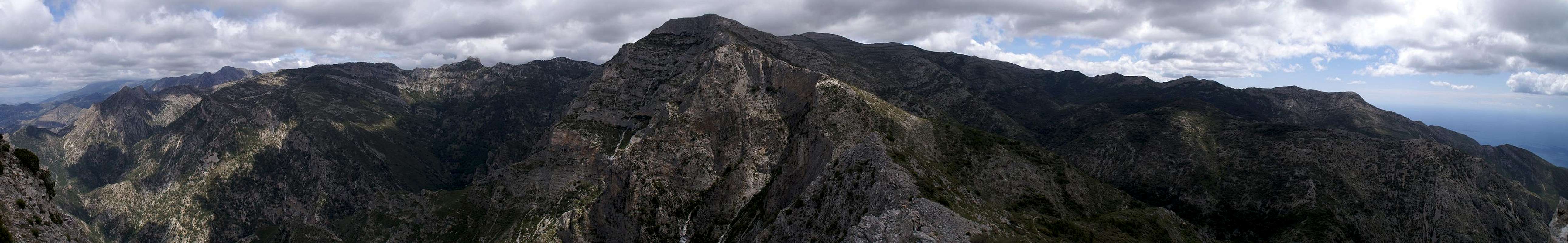
On top of the mountain you are awarded with great views across the Andalusian coast, Costa del Sol. On fine days the North African can be seen but the real attraction is Sierra de Almijara close by. Almendron towers above the Chillar Valley across which you can see the Almijara main ridge with Cerro de Lucero and Navachica, the highest mountains of the range. In the west, in the smaller Sierra de Tejeda, you will see Spain's westernmost continental 2000er, La Maroma, a big, flat-topped mountain with an impressive south face.
 Almendron from El Pinarillo Almendron from El Pinarillo |  La Puerta from El Cielo La Puerta from El Cielo |  Almendron from El Cielo Almendron from El Cielo |  Almendron from Cielo trailhead Almendron from Cielo trailhead |
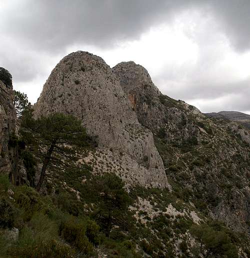
One forther attraction is a big tower at La Puerta, a saddle to the south of Almendrón. I don't have information on its accessibility but from what I have seen I would estimate the easiest route (from the north) to have a rating of an exposed UIAA III - IV.
Summit Panorama
  |
Getting There
 Almendron seen from the south
The trailhead to Almendrón, the parking lot at Cueva de Nerja or the picnic area El Pinarillo at the mouth of Barranco de Cazadores can be easily reached from the towns and villages along the Costa del Sol. Nerja has two exits on the motorway A7, which runs along the coast. Take the eastern of these exits and follow the signs to Maro / Cueva de Nerja.
Two or three roundabouts later you will head up into Maro village at the beginning of which you will find a parking lot on the left side of the road. Either park here or drive across it onto the dirt road,, which heads for the picnic area El Pinarillo 5km to the north at the mouth of the barranco. The road is very potholed, you have to take great care.
Red Tape
 Iris blossom on the Almendron slopes
Almendrón, like all of the surrounding mountains belongs to the Parque Natural de las Sierras de Tejeda, Alhama y Almijara. The usual restrictions apply. The ranges are used for farming and mining so you are free to use the web of dirt roads which covers them. Aside the roads you are requested to stay on the trails, which generally are well maintained.
Especially in spring the lower ranges are covered with millions of wild flowers. Please leave them in their places. Also, in the higher areas you are bound to find herds of Iberian Ibexes. The animals, especially the males, are so used to visitors that you can barely disturb them.
Accommodation
 Sierra de Almijara above the Chillar Valley
The Costa de la Sol is one of Europe's major vacation getaways and there are all types of accommodation to be found. Hotels, apartments, fincas can be booked from any tourist office all over Europe and there are many sites on the net which deal with the area.
The closest town is Nerja, 3km to the west of the trailhead in Maro. You can find all types of accommodation there. The closest campground is in Maro itself.
Weather conditions

Maps & Books
There is a good map of Sierra de Almijara, which, however, is hard to come by. It even shows Almendrón on its cover.- Sierra de Almijara Mapa Topographico
Editor: Miguel Angel Torres Delgado
1:25000
ISBN: 978-6-99-000430-3
As guidebook I can recommend the following one which is available in German and English
- Andalucia South / Andalusien Süd
Costa del Sol – Costa de la Luz – Sierra Nevada
Bernhard Plikat (translation: Gill Round)
Rother Verlag
ISBN 978-3-7633-4824-4 (English)
ISBN 978-3-7633-4147-4 (German)