


-
 3301 Hits
-
 77.48% Score
-
 8 Votes
|
|
Route |
|---|---|
|
|
45.65660°N / 7.27544°E |
|
|
Hiking |
|
|
Spring, Summer, Fall |
|
|
A long day |
|
|
E/F (Easy) |
|
|
Note
|
La montagna chiama i suoi figli, ed essi rispondono fedelmente al suo appello… Osvaldo Cardellina, Diario alpinistico, 1964-65 Page texts: @ OsvaldoCardellina "Osva", passed away on May 2, 2022. Page owners: Christian Cardellina e Osvaldo Cardellina. Any updates from September 12, 2022: Antonio Giani, page administrator, friend and climbing companion. Testi della pagina: @ OsvaldoCardellina "Osva", scomparso il 2 maggio 2022. Proprietari pagina: Christian Cardellina e Osvaldo Cardellina. Eventuali aggiornamenti dal 12 settembre 2022: Antonio Giani, amministratore della pagina, amico e compagno di salite. |
Panning Overview Marginalized
This small "Cima" is marginalized and out of touch. In fact it belongs to the Mont Emilius Group, but almost no one knows. Like the Arabic Phoenix, "everyone knows that is there, but no one knows where he is". The fault is also a little his because results small (2.338m), surly and hanging off and out to admire the Grivola. Almost envious, with a dark look over the Grand Eyvia and the other eye facing Ozein, Hamlet of Aymavilles. A "double-faced" in the balance between the Valley of Baltea and that of Cogne Commune.
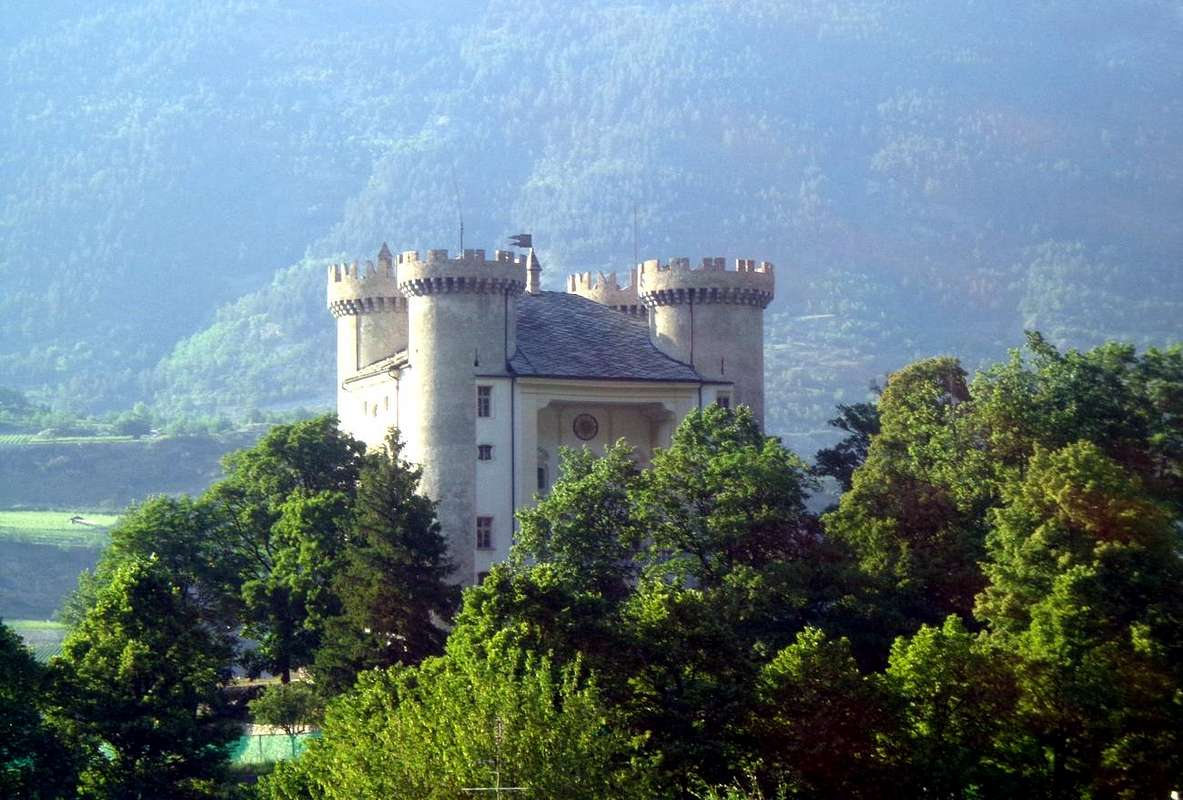
An Easy but quite long excursion leads from the junction of Dailleuy, just after the Ozein Fraction (1.369m, 1.480m), to Pastures of Rompérein Champchenille (1.867m, 2.212m), intermediate route in the direction of "La Pera" with skiing or snow rackets, in a nice and quite long Excursion that reaches the next Borbolet Dèsott, Damon or Borbolet Vlou, la Pierre (2.108m, 2.072m, 2.077/119m) Pastures, on-site "la Pira". By the latter easily and in a short time you get to Punta Vadaille or Vedailles (2.338m) above a rocky promontory of over 1.000 meters on the Grand'Eyvia Stream descending from Gran Paradiso (4.061m) and passing through the Cogne-Resort. An unusual view of the entire massif with superb views on the very close Grivola (3.969m), incidentally always in evidence on all routes to the "La Pera". The other itineraries, with routes from the plain of the Baltea to the low and medium hill below to it, as well as to allow a good to kick one's legs to make beautiful tours in the historical-cultural aspect in an area already well known is that by the Salassi and from the Romans more than 2000 years and offering well leftovers significant vestiges of Medieval castles, towers and civil construction. Also just as full of ideas it comes visiting religious sites with the remains of ancient Churches and votive Chapels, are still popular today. Regarding the Walks around the ancient settlements of Joventianus or Juventanum (Jovençan) and Aimus et Avilius (Aymavilles) or to the archeologic site of Pondel or Pont d'Ael with a Roman Bridge of III° Century BC we leave completely free choice according to the imagination of each one, remembering only that a dense network of trails connects these adjacent commons. Coordinating a beautiful Hike with a juicy Cultural Visit ...
![]()
![]()
An Easy but quite long excursion leads from the junction of Dailleuy, just after the Ozein Fraction (1.369m, 1.480m), to Pastures of Rompérein Champchenille (1.867m, 2.212m), intermediate route in the direction of "La Pera" with skiing or snow rackets, in a nice and quite long Excursion that reaches the next Borbolet Dèsott, Damon or Borbolet Vlou, la Pierre (2.108m, 2.072m, 2.077/119m) Pastures, on-site "la Pira". By the latter easily and in a short time you get to Punta Vadaille or Vedailles (2.338m) above a rocky promontory of over 1.000 meters on the Grand'Eyvia Stream descending from Gran Paradiso (4.061m) and passing through the Cogne-Resort. An unusual view of the entire massif with superb views on the very close Grivola (3.969m), incidentally always in evidence on all routes to the "La Pera". The other itineraries, with routes from the plain of the Baltea to the low and medium hill below to it, as well as to allow a good to kick one's legs to make beautiful tours in the historical-cultural aspect in an area already well known is that by the Salassi and from the Romans more than 2000 years and offering well leftovers significant vestiges of Medieval castles, towers and civil construction. Also just as full of ideas it comes visiting religious sites with the remains of ancient Churches and votive Chapels, are still popular today. Regarding the Walks around the ancient settlements of Joventianus or Juventanum (Jovençan) and Aimus et Avilius (Aymavilles) or to the archeologic site of Pondel or Pont d'Ael with a Roman Bridge of III° Century BC we leave completely free choice according to the imagination of each one, remembering only that a dense network of trails connects these adjacent commons. Coordinating a beautiful Hike with a juicy Cultural Visit ...
Questa piccola Cima risulta emarginata e pressocché fuori dal mondo. Infatti appartiene al Gruppo del Monte Emilius, ma par che quasi nessun ben lo sappia. Come l'Araba Fenice "tutti san che vi sia, dove sia nessun lo sà". La colpa é un pò anche sua perché risulta piccola (2.338 m) e scontrosa, restando in disparte ad ammirare la Grivola. Quasi invidiosa e con uno sguardo cupo sopra la Grand'Eyvia e l'altro occhio rivolto ad Ozein. Un "double-face" in bilico tra la Valle della Dora Baltea e quella di Cogne.
Una facile ma piuttosto lunga Escursione conduce dal bivio di Dailleuy, subito dopo la Frazione di Ozein (1.369 m, 1.480 m), agli Alpeggi di Rompérein e Champchenille (1.867 m, 2.212 m), itinerario intermedio in direzione della "La Pera" raggiungendo i successivi Alpeggi di Borbolet Dèsott e Damon o Vlou e di la Pera o la Pierre (2.108 m, 2.072 m, 2.077/119 m), in loco "la Pira". Da quest'ultima facilmente ed in breve tempo s'arriva alla Punta Vadaille o Vedailles sopra un salto roccioso d'oltre 1.000 metri sul Torrente Grand'Eyvia che scende dal Gran Paradiso (4.061 m) passando attraverso Cogne. Una vista inusuale su tutto il Massiccio con scorci superbi sulla vicinissima Grivola (3.969 m), daltronde sempre in grande evidenza su tutti gli itinerari verso la "La Pera". Gli altri itinerari, con percorsi dalla piana della Dora Baltea verso la bassa e la media collina sottostantemente alla medesima, consentono oltre che a una buona sgambata d'effettuare belle visite sotto l'aspetto storico-culturale in un'area già notevolmente conosciuta sia dai Salassi che dai Romani da oltre 2000 anni e che offre pure resti notevoli di vestigia Medioevali con castelli, torri e costruzioni civili. Inoltre altrettanto ricca di spunti si presenta la visita di luoghi religiosi con resti di antiche Chiese e Cappelle votive, ancora oggigiorno popolari. Per quanto concerne la Passeggiate intorno agli antichi insediamenti di Joventianus or Juventanum (Jovençan) ed Aimus et Avilius (Aymavilles) ed al sito archeologico di Pondel o Pont d'Ael con ponte romano del III° avanti Cristo lasciam completamente libera scelta secondo la fantasia d'ognuno, ricordando soltanto che una fitta ragnatela di sentieri collega questi limitrofi comuni. Coordinando bell'Escursione a Visita Culturale ...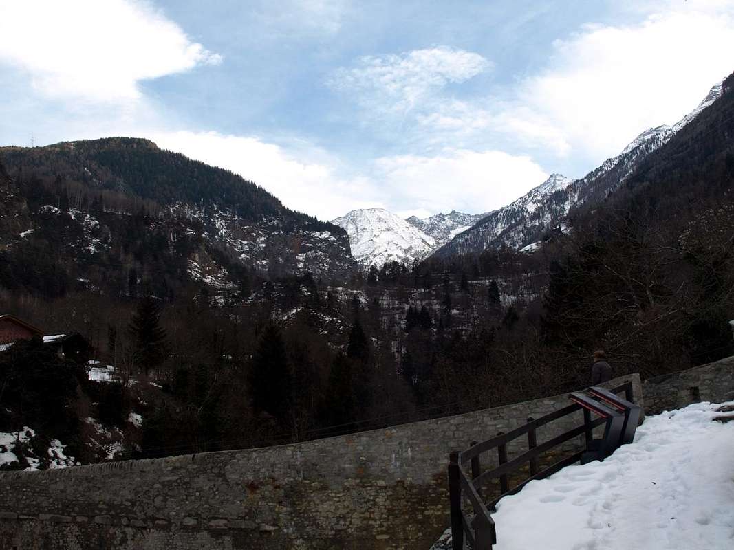
Getting There
BY CAR:
- From TORINO, MILANO, etc: Motorway A5. Exit at IVREA or Quincinetto (PIEDMONT).
- From IVREA Town: Charvensod, Gressan, Jovençan, Aymavilles Municipalities. From Aymavilles (646m) before through Main Road in Southwest towards the Cogne Valley until the junction 958 metres preceding Pondel Village; after with the alternative road in East-southeast to Ozein/Turlin Dessus Hamlets (1.369m, 1.536m) and dirt road to the South from the fork near Dailleuy Village (1.480m).
- From FRANCE: through the Mont Blanc Tunnel to Entrèves-crossroads to Vény/Ferret Valleys - Mountain Guides of Courmayeur - La Saxe Rock Gym - Courmayeur. By Little Saint Bernard Pass, closed since November until half May to La Thuile Valley - Pré Saint Didier - Courmayeur. It is not necessary to take Motorway A5: you can drive on SS.26, in the direction of AOSTA - IVREA - TURIN.
BY PLANE:
- Aeroporto "Corrado Gex" Saint Christophe (Aosta).
![]()
![]()
![]()
Approaches & Routes Description
1) - Ski touring trip to Pointe de la Pierre starting from Ozein Village (1.349m), Dailleuy resort (1.480m) and through the slope of the North-northwest Face:
on the Regional road by Aymavilles towards Cogne Valley, before reach Ozein Hamlet, (1.349m) with Parking in place near Belley 1.369m). From Ozein you can go on, along the road to Turlin Dessus and Low, till a fork on the right side, wherefrom starts the farm road, (concomitant with the path n° 1, leading to the mountain Pastures of Romperein (1.867m) and to the next of Champchenille (2.212m). This, of course if the road is free, normally in winter you have to start from Ozein and get this point along some short cuts, avoiding the 7 km of the road. From Champchenille, ascending on fine slopes, straight to the Summit, by ski (BSA; 3h'00/4h'00 from Dailleu also Dailleuy alternative).
2) - Circular Tour by people with snowshoes starting from the fork of Dailleuy (1.490m) passing Alpages Rompérein, Champchenille, Borbolet Low and La Ruì:
this tour can be carried out indifferently on one side or the other.
a) - In fact, reached the Pastures of Rompérein, you can continue to Southeast as in the previous itinerary and path 1 until Campchenille; from here, leaving to the left (East) the way for the "Pera", go down briefly with unnumbered path to Borbolet Alpe di Sotto (Low; 2.108m) and from there via a detour onto a farm dirt road to the nearby La Rui Alpage (1.923m). From the latter, with the farm road that reaches the High Pastures Bardoney and la Pierre, it descends again to those of Rompérein and Titeun (1.760m) closing the circle.
b) - Or from 1.706 meters junction, after the Alp isolated from the Premou (1.685m) and before the nearby Titeun Pasture, you continue with the trail n° 8 that comes from Ozein-Belley-Léonard-Chantal reaching La Ruì (F; 3h'00/4h'00 for both directions of travel).
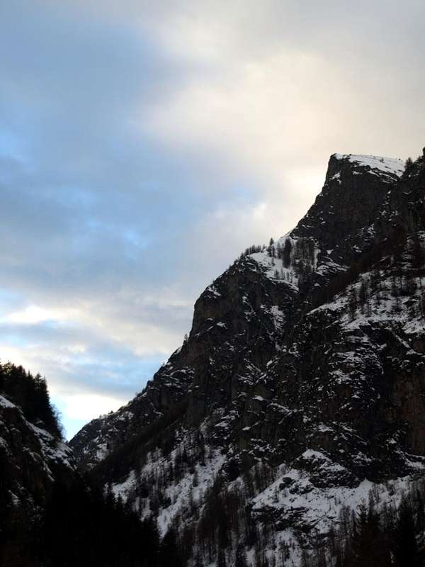
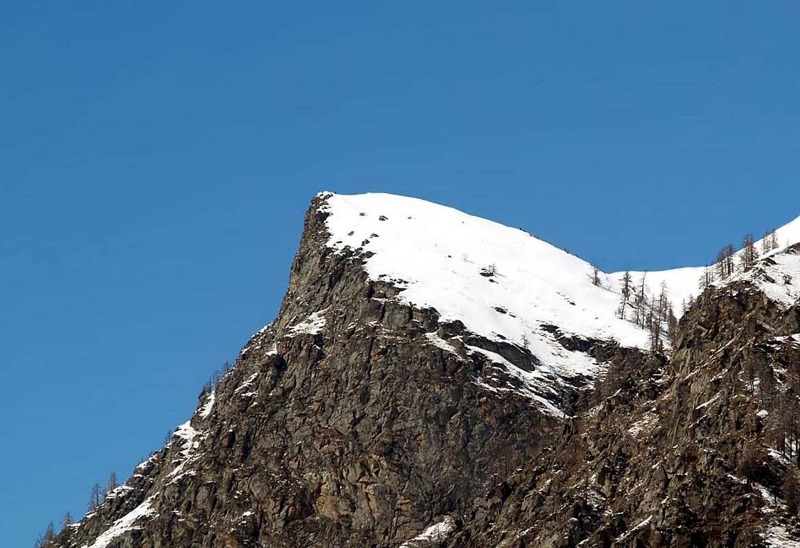
3) - Beautiful and long Excursion towards the Alpages of Barbolet Dèsott or Lower and Barbolet de Viou and that upper of la Pierre reaching the Pointe Vadaille:
through the preceding routes up to La Ruì or Lower Borbolet Alpages; from the both in South with trail n° 8 reach the most ancient Borbolet Viou or Damon Pasture and subsequent always very ancient of la Pierre highest Alpage (2.072m, 2.077m). From La Pierre Alp continue to fork 2.303 meters and from this, with path n° 8 in South, with small path always n° 8 and debris and traces at the end bypassing some easy and small rock in final part, to Pointe Vadaille or Vedailles (2.338m; E/F;0h'45/1h'00 by La Pierre Alp).
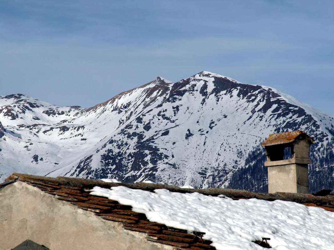
![]()
North-northwern Slope over la Pierre or "la Pira" & Bardoney Alpages
1) - Sci-Alpinistica alla Pointe Vadaille con partenza dal Villaggio d'Ozein (1.349 m) località Dailleuy (1.480 m) tramite il pendio del Versante Nord-nordovest :
Dal Villaggio di Ozein raggiungibile con la Strada Regionale che da Aymavilles raggiunge Cogne (1.349 m); parcheggio nella piazzetta presso la località Belley (1.369 m), continuare per la strada di Turlin Dessus e Dessous insino al bivio sulla destra dove inizia la strada poderale (concomitante con il sentiero n° 1; , che conduce all'Alpeggio di Rompérein (1.867 m), proseguire sino all'Alpe di Champchenille (2.212 m). Da questo punto si può salire anche per scorciatoie evitando i 7 km della strada poderale. Dall'Alpeggio di Champchenille puntare, su splendidi pendii prativi, seguendo la poderale alla Vetta, che si raggiunge sempre con gli sci (BSA; 3h'00/4h'00 dalla località di Dailleuy o anche Dailleu).
2) - Giro circolare con le racchette da neve partendo dal bivio di Dailleuy (1.490 m) e passando le Alpi Rompérein, Champchenille, Borbolet Dèsott fino a La Ruì:
questo tour può essere effettuato indifferentemente da un lato o dall'altro.
3) - Beautiful and long Excursion towards the Alpages of Barbolet Dèsott or Lower and Barbolet de Viou and that upper of la Pierre reaching the Pointe Vadaille:
through the preceding routes up to La Ruì or Lower Borbolet Alpages; from the both in South with trail n° 8 reach the most ancient Borbolet Viou or Damon Pasture and subsequent always very ancient of la Pierre highest Alpage (2.072m, 2.077m). From La Pierre Alp continue to fork 2.303 meters and from this, with path n° 8 in South, with small path always n° 8 and debris and traces at the end bypassing some easy and small rock in final part, to Pointe Vadaille or Vedailles (2.338m; E/F;0h'45/1h'00 by La Pierre Alp).
1) - Sci-Alpinistica alla Pointe Vadaille con partenza dal Villaggio d'Ozein (1.349 m) località Dailleuy (1.480 m) tramite il pendio del Versante Nord-nordovest :
Dal Villaggio di Ozein raggiungibile con la Strada Regionale che da Aymavilles raggiunge Cogne (1.349 m); parcheggio nella piazzetta presso la località Belley (1.369 m), continuare per la strada di Turlin Dessus e Dessous insino al bivio sulla destra dove inizia la strada poderale (concomitante con il sentiero n° 1; , che conduce all'Alpeggio di Rompérein (1.867 m), proseguire sino all'Alpe di Champchenille (2.212 m). Da questo punto si può salire anche per scorciatoie evitando i 7 km della strada poderale. Dall'Alpeggio di Champchenille puntare, su splendidi pendii prativi, seguendo la poderale alla Vetta, che si raggiunge sempre con gli sci (BSA; 3h'00/4h'00 dalla località di Dailleuy o anche Dailleu).
2) - Giro circolare con le racchette da neve partendo dal bivio di Dailleuy (1.490 m) e passando le Alpi Rompérein, Champchenille, Borbolet Dèsott fino a La Ruì:
questo tour può essere effettuato indifferentemente da un lato o dall'altro.
a) - Infatti, raggiunto l'Alpeggio di Rompérein, si può continuare verso Sudest come per il precedente itinerario e sentiero n° 1 fino a Campchenille; da qui, lasciando a sinistra (Est) la via della "Pera", si scende brevemente con sentiero non numerato all'Alpe di Borbolet di Sotto (2.108 m) e da questa tramite deviazione sulla poderale alla vicina di La Ruì (1.923 m). Da quest'ultima, con la strada poderale che raggiunge gli Alpeggi di Bardoney e la Pierre, si scende nuovamente a quelle di Rompérein e Titeun (1.760 m) chiudendo il cerchio.
b) - Oppure dal bivio 1.706 metri, dopo l'Alpeggio isolato di la Premou (1.685m) nonché prima di quello vicino di Titeun, si continua con il sentiero n° 8 che proviene da Ozein-Belley-Léonard-Chantal raggiungendo La Ruì (F; 3h'00/4h'00 per entrambi i sensi di marcia).
3) - Bella e lunga Escursione in direzione delle varie Alpi di Barbolet Dèsott o di Sotto e Barbolet de Viou e quella di la Pierre raggiungendo la Pointe Vadaille:
tramite i precedenti itinerari insino all'Alpe La Ruì oppure ai viciniori Alpeggi del più recente Borbolet di Sotto; da entrambi e verso Mezzogiorno con il sentiero n° 8 raggiungere il più antico Borbolet Viou o di Sopra ed il successivo sempre antico di la Pierre (2.072 m, 2.077 m). Dall'Alpe La Pierre raggiungere la meta continuando verso Sud, con piccolo sentiero sempre n° 8 e tracce detritiche nel finale zigzagando fra qualche facile roccetta, alla Punta Vadaille o Vedailles (2.338 m; E/F;0h'45/1h'00 dall'Alpeggio di La Pierre).
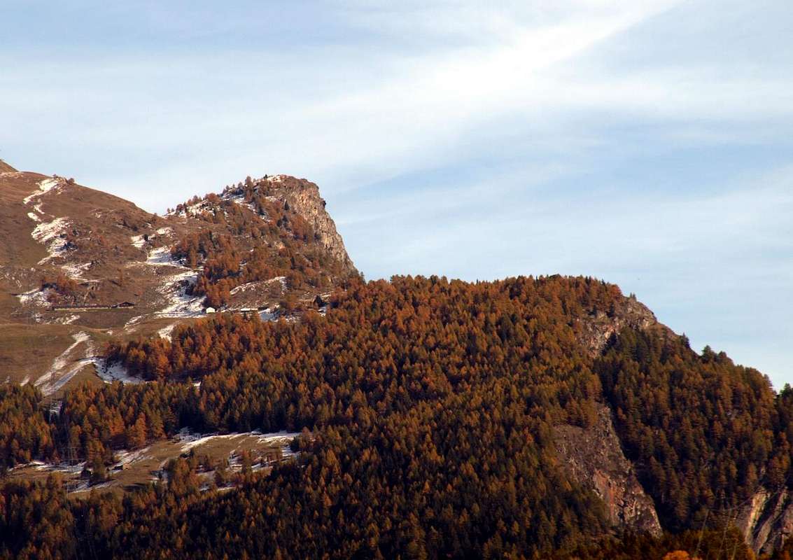
![]()
South-southeastern Face above the Grand'Eyvia Torrent in Cogne Valley
L'itinerario è classificato E oppure EE/BSA (Buoni Sciatori Alpinisti) in inverno tramite Sci-Alpinismo od in Racchette da neve.
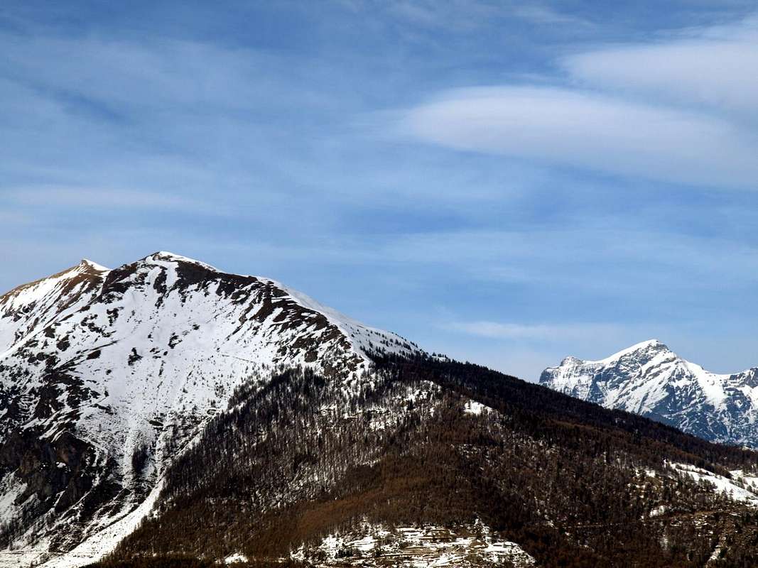
![]()
By Ozein to the North
Hiking gear or in winter with ski and snowshoes (better with ARVA; in case of dangerous snow stop at Champchenille).
Da Escursionismo oppure in inverno tramite Sci oppure in Racchette da neve (meglio con ARVA; in caso di neve pericolosa fermarsi a Champchenille).
3) - Bella e lunga Escursione in direzione delle varie Alpi di Barbolet Dèsott o di Sotto e Barbolet de Viou e quella di la Pierre raggiungendo la Pointe Vadaille:
tramite i precedenti itinerari insino all'Alpe La Ruì oppure ai viciniori Alpeggi del più recente Borbolet di Sotto; da entrambi e verso Mezzogiorno con il sentiero n° 8 raggiungere il più antico Borbolet Viou o di Sopra ed il successivo sempre antico di la Pierre (2.072 m, 2.077 m). Dall'Alpe La Pierre raggiungere la meta continuando verso Sud, con piccolo sentiero sempre n° 8 e tracce detritiche nel finale zigzagando fra qualche facile roccetta, alla Punta Vadaille o Vedailles (2.338 m; E/F;0h'45/1h'00 dall'Alpeggio di La Pierre).

Essential Gear
This route can be considered E or EE/BSA (Experts Hikers or Good Skiers-Montaineers) in winter by Ski-Mountaineering or Snowshoeing.L'itinerario è classificato E oppure EE/BSA (Buoni Sciatori Alpinisti) in inverno tramite Sci-Alpinismo od in Racchette da neve.
By Ozein to the North
Hiking gear or in winter with ski and snowshoes (better with ARVA; in case of dangerous snow stop at Champchenille).
Da Escursionismo oppure in inverno tramite Sci oppure in Racchette da neve (meglio con ARVA; in caso di neve pericolosa fermarsi a Champchenille).
Campings
Remember that free camping is forbidden (except for emergency reasons, over 2.500m, from darkness until dawn).
Mountain Condition
- Meteo: you can find all the needed informations at the official site of the Valle d'Aosta Region:
- Valle d'Aosta Meteo
Books and Maps
- "Guida del Monte Emilius", di Osvaldo Cardellina Editore in collaborazione con il Club Alpino Italiano Sezione di Aosta, Dicembre 1978.
- "Guida dei Monti d'Italia – Emilius Rosa dei Banchi Parco del Mont Avic" di Giulio Berutto e Lino Fornelli - Club Alpino Italiano/Touring Club Italiano, Marzo 2005.
- "Guida delle Alpi Occidentali" di Giovanni Bobba e Luigi Vaccarone C.A.I. Sezione di Torino Volume II (parte II), 25 Maggio 1896.
- "80 itinerari di Escursionismo Alpinismo e Sci Alpinismo in Valle d'Aosta", di Osvaldo Cardellina, Ed. Musumeci, Giugno 1977 (in Italian); seconda Ed. Luglio 1981; terza Ed. Luglio 1984; (in French), prima Ed. Febbraio 1978; seconda Ed. Marzo 1980.
 |
 |
 |
- Kompass "Gran Paradiso Valle d'Aosta Sentieri e Rifugi" Carta turistica 1:50.000.
- L'Escursionista "Conca di Aosta-Pila-Monte Emilius" Carta dei sentieri (n° 4) 1:25.000.
- Hapax "Les Sentiers Comunità Montana Monte Emilius", Luglio 2000 1:25.000.
- Enrico Editore Ivrea-Aosta "Gruppo del Gran Paradiso" 1:50.000.
- I.G.C. Istituto Geografico Centrale, Torino "Carta delle Passeggiate ed Escursioni in V.D.A. Conca di Pila-Gressan, 1:20.000.
Important Information
- REGIONE AUTONOMA VALLE D'AOSTA the official site.
- FONDAZIONE MONTAGNA SICURA Villa Cameron, località Villard de la Palud n° 1 Courmayeur (AO) Tel: 39 0165 897602 - Fax: 39 0165 897647.
- A.I.NE.VA. (Associazione Interregionale Neve e Valanghe).
Useful numbers
- Protezione Civile Valdostana località Aeroporto n° 7/A Saint Christophe (Ao) Tel. 0165-238222.
- Bollettino Valanghe Tel. 0165-776300.
- Bollettino Meteo Tel. 0165-44113.
- Unità Operativa di Soccorso Sanitario Tel. 118.