An interesting comparison between the driest year (2014) and the wettest year (2011) in Yosemite national park

An interesting comparison between the driest year (2014) and the wettest year (2011) in Yosemite national park

Page Type Page Type: Article
Activities Activities: Hiking, Mountaineering, Bouldering, Big Wall

The wettest year (2011) vs the driest year (2014) in Yosemite national park

On September 5th, 2011, a friend of mine and I climbed Mt. Conness in the eastern part of the Yosemite national park. The year 2011 was the wettest year on record in the north of Sierra-Nevada range. The scenery was spectacular. I don’t think anybody had ever seen that much snow in the month of September in Yosemite national park. You can see my album here.

On the other hand the year 2014 was one of the driest years (if not the driest) on record in California. In order to get some sense of the difference between 2011 and 2014, you can look at the amount of snowfall in several spots in northern Sierra-Nevada range. For example the average amount of annual snowfall on top of Squaw valley ski area is about 450”. In 2010/2011 that was 810”, and in 2013/2014 it was 297.5”. In fact in Squaw valley in the past 20 years, 2011 was the only year with snowfall higher than 700”, and 2014 was the only year with snowfall lower than 300”.

I (along with 2 friends) decided to go to Mt. Conness one more time on September 1st, 2014, to compare the sceneries.

One of the starting points to climb Mt. Conness is near the Saddlebag lake. Since we got there at around 2PM, and we wanted to come back before dark, we decided to just get to the Conness ridgeline . First we took a taxi boat to get to the other side of Saddlebag lake to start the hike. When you are on the boat you can see Mt. Dana (13053’) and Mt. North Peak (12242’). The elevation of Saddlebag lake is 10060’. Here are some photos from 2011 and 2014:


Saddlebag lake
Saddlebag lake (September 1, 2014)
    
saddlebag lake
Saddlebag lake (September 5, 2011)


Mt. Dana
Mt. Dana from Saddlebag lake (September 1, 2014)
   
Mt. Dana
Mt. Dana from Saddlebag lake (September 5, 2011)


North Peak
North Peak from Saddlebag lake (September 1, 2014)
   
North peak
North Peak from Saddlebag lake (September 5, 2011)


It is interesting to see Mt. North Peak with so much snow in September 2011, and with almost no snow in September 2014.

When you get off the boat you can start your hike. After a very short time you will see another lake called greenstone. You can take the trail going to the left side of the lake.


Mt. Conness and North Peak
Conness and North Peak (September 1, 2014)
 
Mt. Conness and North peak
Conness and North Peak (September 5, 2011)


North Peak
North Peak and Greenstone lake (September 1, 2014)
 
North peak and Greenstone lake
North Peak and greenstone lake (September 5, 2011)


After you pass Greenstone lake you will see a waterfall. You should hike up from the right side of the waterfall then Mt. Conness will be visible again.


Waterfall
The waterfall (September 1, 2014)
 
waterfall
The waterfall (September 5, 2011)


Besides the glaciers and the impressive rock walls of Mt. Conness, what makes this mountain unique in the Sierra-Nevada range is the number of lakes you can see around it (more than 20).


Mt. Conness
Mt. Conness (September 1, 2014)
 
Mt. Conness
Mt. Conness (September 5, 2011)


Mt. Conness and Conness lake
Mt. Conness and the lower Conness lake (September 1, 2014)
 
Mt. Conness
Mt. Conness and the lower Conness lake (September 5, 2011)


Something that caught my attention was the rocks on the other side of the lower Conness lake. Apparently something has changed in the past 3 years. I need to figure it out.

From the left side of the lower Conness lake you can start hiking/climbing the mountain to get to the Conness ridgeline.


Mt. Conness
On the way to Conness ridgeline (September 1, 2014)
 
Mt. Conness
On the way to Conness ridgeline (September 5, 2011)


North Peak
North Peak (September 1, 2014)
 
North peak and Conness lakes
North Peak (September 5, 2011)


Looking South
Looking south (September 1, 2014)
 
looking south
Looking south (September 5, 2011)


Mt. Lyell and Mt. Maclure
Mt. Lyell and Mt. Maclure in the distance (September 1, 2014)
 
Mt. Lyell and Mt. Maclure
Mt. Lyell and Mt. Maclure in the distance (September 5, 2011)


Mt. Lyell and Mt. Maclure
Mt. Lyell and Mt. Maclure (September 1, 2014)


As you see there is a big difference between 2011 and 2014 as far as snow cover is concerned. In a typical year in the month of September the snow cover is kind of like 2014. The year 2011 was exceptional. I remember on 4th of July 2011 some of the runs in Squaw valley ski area were open which is very unusual.

I didn't take any picture from Yosemite valley. Unfortunately, all the waterfalls except Vernal falls and Nevada falls are dry.


Comments

Post a Comment
Viewing: 1-17 of 17
nader

nader - Sep 23, 2014 5:56 pm - Voted 10/10

This is amazing

What a difference!

kamran

kamran - Sep 23, 2014 11:53 pm - Hasn't voted

Re: This is amazing

Yes, it is really amazing. Since 2011 we have had 3 years of drought. A rainy season is badly needed in California.

Matt Lemke

Matt Lemke - Sep 24, 2014 12:40 am - Voted 10/10

A new camera...

was purchased between 2011 and 2014 ;)

Excellent article!

kamran

kamran - Sep 24, 2014 9:33 am - Hasn't voted

Re: A new camera...

Thank you Matt.
I actually did purchase a new camera!:)

JRB

JRB - Oct 12, 2014 7:24 am - Voted 10/10

The trips can be so different from year to year

We experienced the same situation on the High Divide on the Olympic Pennisula in both 2009 and 2012. Completely different conditions from dry alpine ridge to 4 feet of snow. Mother Nature makes things interesting. I enjoyed your article. Thanks

kamran

kamran - Oct 12, 2014 2:45 pm - Hasn't voted

Re: The trips can be so different from year to year

Thanks for visiting this page.
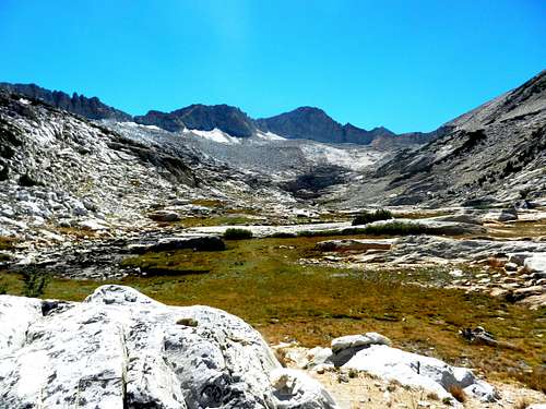
You are absolutely right. However, we may see big differences from year to year when we compare the situations in the Spring or early Summer. It is unusual to see this much difference in late Summer (September) before new storms hit.

phydeux

phydeux - Oct 25, 2014 11:08 am - Hasn't voted

Nice comparson

Great shots. It'd be interesting if someone had some shots from fall 2005; the 2004-2005 winter produced about 2.5X the normal rainfall/snowfall, and much of the Sierra Nevada was socked in for much of the summer. Telescope Peak (Death Valley) still had snow on it in fall 2005(!). Yosemite Valley - had a co-weisititfor th first time recently, and they were bummed the falls didn't have any water!

kamran

kamran - Oct 25, 2014 1:55 pm - Hasn't voted

Re: Nice comparson

Thanks for your comments.
You are right. The precipitation in 2004-2005 was high, but it was mostly in southern Sierra Nevada range. In the northern part including Yosemite national park it was not as much.

SkiOrClimb - Nov 3, 2014 4:03 pm - Hasn't voted

Cool Post

A couple things:
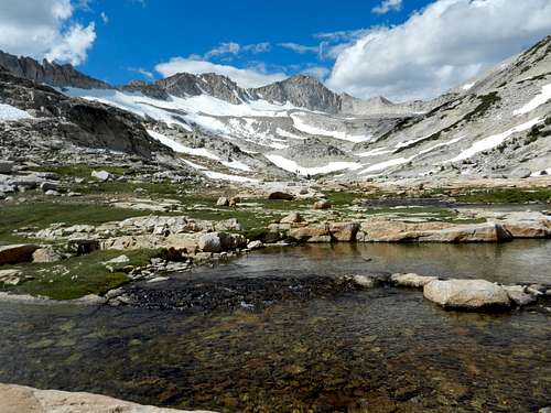
1. Quibbling with your superlative use. 2011 was not the wettest year on record. 82-83 was by far the biggest year for snow-water content (e.g. "the wettest") in the Central-Northern Sierra. 2011 wasn't even the biggest year in terms of measured snowfall. See: http://www.thestormking.com/Weather/Sierra_Snowfall/sierra_snowfall.html It was only the fifth biggest in terms of snow on the ground at once. Where it was biggest, was in terms of snow on the ground in mid-June and other points later in the year--the most since Central/Southern Pacific started keeping track at Norden in 1868. That's because it was a huge year, and then stayed snowy and cold way longer into the spring than usual.
2. It'd be interesting to see a comparison between 2014 (or better, 2013 because it stopped snowing sooner last year) and an "average" year--if such a thing exists in CA.

Thanks for throwing up the photo comparison. I was up in that area in late May/early June and skied North Peak on May 31. Fun times.

kamran

kamran - Nov 4, 2014 5:22 am - Hasn't voted

Re: Cool Post

Thanks for the explanation and for the link.
please take a look at the following link:
http://www.iceagenow.com/Squaw_Valley-Most_snow_in_recorded_history.htm
I think I know the source of the discrepancies. When I say 2011, I mean 2010/2011 snow season which starts on October 1, 2010 and ends on September 30, 2011. I think in the bar diagram in your link, 2011 starts on January 1 and ends on December 31, 2011.

SkiOrClimb - Nov 10, 2014 3:15 pm - Hasn't voted

Re: Cool Post

Squaw's records only go back to 1958, if that. That was the year the resort opened. The accuracy of their measurement is dubious as well, given that ski resorts notoriously overstate their snowfall numbers for marketing purposes.

The Central Sierra Snow Lab, and the railroad before that, is the acknowledged keystone for historic data used by water managers and such. And, no, the bars in that graph are for the water year, which runs October 1-September 30--so it is actually a direct comparison.

Alex Wood

Alex Wood - Nov 10, 2014 4:00 am - Hasn't voted

Thanks

Thanks for taking the time to put this together. Awesome photos from both years.

kamran

kamran - Nov 10, 2014 11:09 am - Hasn't voted

Re: Thanks

Thank you for visiting this page, and thank you for your comments.

ktnbs

ktnbs - Sep 20, 2015 4:43 pm - Hasn't voted

most cool

to look at and compare

kamran

kamran - Sep 20, 2015 5:17 pm - Hasn't voted

Re: most cool

Thanks for your comment.

MoapaPk

MoapaPk - Oct 2, 2015 4:38 pm - Hasn't voted
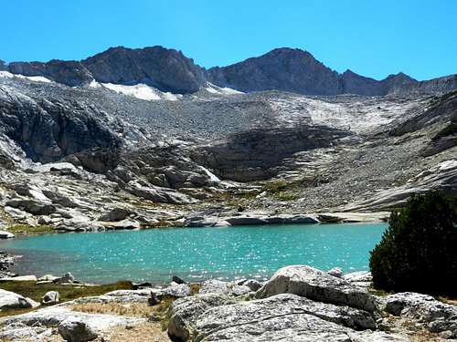
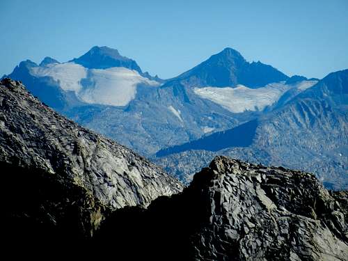
2011 and 2015

I was there in Sept both years. The retreat of the Conness Glacier is sobering.

kamran

kamran - Oct 2, 2015 8:15 pm - Hasn't voted

Re: 2011 and 2015

Yes, and it is really sad.

Viewing: 1-17 of 17