
|
|
Area/Range |
|---|---|
|
|
16.03196°S / 69.16718°W |
|
|
Hiking |
|
|
Spring, Summer, Fall, Winter |
|
|
13451 ft / 4100 m |
|
|
Overview
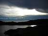
Isla del Sol (Island of the Sun) is located on the South-Eastern side of Lake Titicaca. It gives a great feeling being in the Andes... by the Mediterranean see !The bottom of the Island is at 3800m (altitude of the lake) and the top would reach almost 4100m. The islands is made of hills rather than peaks, therefore it doesn't have specific summit to climb. It is 10 kms long and 4 kms wide.
This place gives a great opportunity to hike on the path of pre-inca civilization, meet with true Aymara population (kids will probably make fun of you using this ancient language), and enjoy a perfect 360° view over Lake Titicaca, the Cordillera Real (Bolivian side) and the Peruvian shores.


Getting There
The only way to reach the island is by boat. No bridge luckily !Take a bus from La Paz to the village of Copacabana (around 3h / 3$), by the lake. Early enough to arrive before 1pm, as the boat leaves at 1:30pm.
It then takes 1h30 to reach the Island and the village of Yumani (3$).
There is another boat at 8:30am.

Hiking on the Island

Undoubtedly, the best thing to do there is hike.
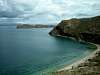
There is a trail going around the island, leaving from the village of Yumani.
Yumani is located at the Southern tip of the Island.
A trail goes along the Western shore and one the Eastern shore.
I reckon it is best to go on the West side to go, and return on the East side.
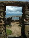
There is 8kms to reach the Northern tip of the Island where you can see the pre-inca ruins of Chincana.
It is a great place for a little lunch.
Then the trails goes to Challapampa, a simple village. Note that the boat arriving from Copacabana also stop there.
You can start walking from there, if you haven't spent the night before in
Yumani.
After Challapampa you will reach the cute village of Challa.
Possibility to sleep there as well, if necessary.
Final step, the trail goes back up to Yumani.
Lodging and Planning


No camping is allowed on the island, as it is a protected area.
You will even have to pay a fee of 10 Bols (1,25 USD) to enter the northern part of the island.
A good (and basic) hostal is Templo del Sol (3$ per person with breakfast).
You can have dinner there for 2$ (excellent lake trout !!)
It is located at the very top of Yumani. The boat will drop you at the bottom of the Inca staircase.
Keep going up until you reach the last couple of Hostals (around 300m higher up). It's there !
Kids can show you around, but will except a tiny fee. They are kind and helpful, and a tip in Bolivia is a lot for them.
In all cases take a sleeping bag, as nights are cold, and hostals don't have thousands of blankets.
The way we did it :
Day 1 :
Early in the morning bus from La Paz to Copacabana
Lunch in Copacabana
Boat at 1:30pm to Isla del Sol.
Late afternoon and evening, relaxing at the Hostal enjoying the view on the Cordillera Real
Day 2 :
Hiking around the Island, clockwise if you go with the Western Trail to Chincana and return on the Eastern trail.
Night at the same Hostal. You just need water and some snack or fruit.
Day 3 :
Boat back to Copacabana, and chilling out there, as there is a cool atmosphere.
Night there, and return to La Paz the next day.
Book & Weather
Two guidebooks can be recommended :Peru and Bolivia Trekking Guide (Bradt)
Trekking in the Central Andes (Lonely Planet)
And for Weather check forecast in : Challapampa

Eleutheros - Jun 21, 2007 5:17 pm - Voted 10/10
CoordinatesLocation???
Andino - Jun 22, 2007 3:21 am - Hasn't voted
Re: CoordinatesAdded ;o)
Crotch - Jul 30, 2007 8:08 pm - Hasn't voted
Getting ThereYou can also hike from Copacabana to Yampupata and hire a boat for 70 Bolivianos (about $9 USD) for the 20 minute crossing to Isla Del Sol (Yumani). The hike is pleasant, passes through some quant agrarian coastal villages, and supports the economy of the towns outside of Copacabana. If you want to avoid breathing diesel fumes there are some places along the hike to Yampupata where you can hire a local villager to row you across to Isla Del Sol.