
-
 22324 Hits
-
 84.82% Score
-
 19 Votes
|
|
Area/Range |
|---|---|
|
|
42.45475°N / 71.09159°W |
|
|
Hiking, Bouldering |
|
|
Spring, Summer, Fall, Winter |
|
|
317 ft / 97 m |
|
|
The Fells - Overview
A few rocks, some modest hills and promontories, interspersed with a moderate decorum of streams, ponds, and marshes, and inserted into thinly mixed hardwood and evergreen woodlands, are all that make up the Middlesex Fells Reserveration in Eastern Massachusetts; what makes these 2500 plus acres remarkable, however, is its location. Cut squarely in half by I-93 it is only a five minute drive from downtown Boston, and yet it gives the casual visitor a wide variety of outdoor activities to choose from on a daily basis, year-round.

|

|
|---|
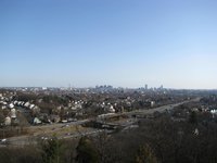
Like the Blue Hills south of Boston, the slightly rugged terrain that makes up “The Fells” ring around Metro Boston's northern reaches, taking up a big chunk of land (3 times larger than NYC’s Central Park) right the interior of the thickly settled 128 Beltway, which surrounds the City on three sides. Located mainly in the blue-collared towns of Medford and Stoneham, with parts abutting into Malden, Melrose, and the very un-blue-collared Winchester, the Fells function more like a sampling of rural environs for local denizens, as opposed to your typical urban park. There no sweeping overlooks nor precarious waterfalls to marvel at, no great river to follow along, no great peak or obstacle to surmount, but due to its proximity to population centers the Fells offer opportunities for hiking, biking, jogging, running, boating (on Spot Pond), fishing, even some casual cragging or bouldering on some anonymous rock faces, and in the winter, snowshoeing and cross country skiing. Built at the northern and southern ends of the Fells are two lookout towers which offer a 360 degree vista of the area, including a most impressive view of the Boston skyline. Unknown to all but those who live in the neighboring towns, the Fells, along with the Blue Hills to the south, are a perfect distraction for a visitor to Boston with a few hours to spare.

|

|
|---|
Getting There
The Fells lie between exits 33 and 35 on I-93 north of Boston. Unless you know the backroads the best way to reach the Fells is via I-93. There are several access points for the Reservation.Coming from the north take Exit 35 (Winchester Highlands). To access Bear Hill take a right off the exit than an IMMEDIATE left into a sideroad besides an industrial park. Otherwise take a left, cross under the highway, then take a right onto North Border Road. At the intersection with Main Street (MA-28) stay straight then bear right onto Woodland Road for the eastern half of the Reservation; the visitor center, boat launch, and a local zoo (The Stone Zoo) are all on Woodland Road. Taking a right on the MA-28 intersection will take you onto Fellsway West, which parallels I-93 and provides access to the Sheepfold trailhead. Staying on Fellsway West will eventually take you to Roosevelt Circle and Exit 33.
Fellsway East can be accessed via the same exit. From Woodland Rd drive past the Stone Zoo and take a left on either Pond Street or Ravine Rd, then take a right (south) onto Fellsway East.
Coming from the South (Boston) take Exit 33. You will enter a large two-lane rotary, known as Roosevelt Circle. Follow signs for MA-28 Fellsway North to access the Fellsway as well as Sheepfold. Staying on the rotary until your second legal right will take you onto South Border Road. To access Woodland Road take the Fellsway North, then bear right, following signs for Elm Street. Follow Elm Street to another rotary, which intersects with the southern terminus of Woodland Road.
Exit-34 does not exist southbound but can take it as a cutoff going north to get on the Fellsway right before the North Border Road intersection. Take a right, right off the highway, for Woodland Rd and Fellsway East.
Exit 35, Winchester Highlands, is not available for northbound drivers.
Driving Map to the Fells:
Driving Map

The Reservation is also accessible via public transportation. From Boston take the Orange Line Oak Grove outbound train. Getting off at Wellington Station and taking bus #100 will take you to Roosevelt Circle. Oak Grove Station is a 10-15 minute walk along several roads to the Reservation as well. Click here for details.
Points of Interest
PDF Trail MapThere are no epic thru-hike trails to be found in the Fells, but that doesn't limit your options. The park has a complex network of "Roads" (resembling carriage roads and closed to automobile travel), bike paths, and hiking trails that criss-cross each other back and forth. A trail map would be handy; they are available for sale at the Visitor Center and local bookstores, in addition to locations in several parking area kiosks (for viewing only). You don't necessarily need to have a destination in mind when visiting the Fells. Just park your car, find a path, and follow the assorted trails to your heart's content. You can always retrace your path, and if you forget it the park is small enough for you to follow a trail that goes in a general direction to find your way back to a road. The well-marked Mountain Bike Path circumnavigates the park and provides an excellent point of reference. However, I've provided below a general guideline of sights and points of interest.
Bear Hill - 317'
What are we here at Summitpost but peakbaggers who are, for the most part, suckers for highpoints? Well Bear Hill, located in the northern end of the Reservation, is the highest point of the Fells. It is most easily accessed via the Winchester Highlands exit (see preceding section). A wide and well marked trail resembling a dirt road leaves the impromptu parking area. This is Bear Hill Rd (like all other roads in the park, no autos). Almost immediately the road bears right, while a trail bears left going directly up a visible cleft on the north face of Bear Hill. Follow the trail to the top. A lookout tower next to a fenced off water treatment plant gives excellent views of the 128 area and not so excellent views of the treatment plant.

|

|

|
|---|
Winthrop Hill - 291'
Continuing south along the Bear Hill Trail or Bear Hill Road will quickly take you a few minutes later up towards Winthrop Hill. Follow the road through the woods to an open incline area to your right. This is the obvious hill, and take a right onto an obvious sidetrail. You quickly arrive at the semi-open summit of Winthrop Hill, a pleasant area with partial views and plenty of places to have a seat. Winthrop Hill can also be accessed via the Sheepfold parking lot.

|
|---|
Pine Hill - 243'
Located right off I-93 on South Border Rd (See directions above), Pine Hill is near the southern terminus of the park and offers another lookout closer to Boston and right next to the denser neighborhoods in Medford. Park at the Bellevue Pond parking lot on South Border Road (often very crowded on weekends). There are several paths that lead to the top of the hill and the lookout tower. The views into Boston are nice, but overall the area is somewhat unpleasant due to a proponderance of broken glass and other forms of litter.
|

|

|

|
|---|
Spot Pond
Non-motorized boats are allowed on this large backup reservoir. All Boats must be rented from Spot Pont Boating on Woodland Rd, near the Stone Zoo.
Boat Rentals
Skyline Trail
One of the more popular trails in the park, the Skyline Trail traverses the hills and ridges of the western portion of the Reservation. Access along South Border Road parking areas and Sheepfold.
Winchester Reservoirs
Several trails and loops bypass and encircle North, Middle, and South Reservoirs in the western section. Actual access to the reservoirs are prohibited; make sure to follow all signs and warnings.
Fells Reservoirs
Accessed from Woodland Rd. The Rock Circuit Trail and Hemlock Pool Rd take you to this reservoir on the eastern side of the park. Observe all posted signs.

|

|
|---|
Black and White Rocks
The Fells aren't much of a destination for serious rock climbers but the Black or White Rocks do offer some easy routes for local climbers. They are part of the Rock Circuit Loop, which can be accessed from either Woodland Rd. or East Border Rd. There are about six or seven crags, with routes ranging from 5.2 to 5.10.
More info
The Cascade
See Nartreb's page for The Cascades, which, when frozen over, offer the best ice climbing near Boston, relatively speaking of course. The Cascades can be accessed from Washington St, an offshoot off the Fellsway East (take a left if coming from the North, right if from the South), between Gould and Shadow St's.
Photo Courtesy of Nartreb

|
|---|
Long Pond
A small pond on the western part of the Reservation. Parking area is several miles up South Border Rd. A nature trail with interpretation signs highlight the area, along with the pond, of course.

|
|---|
Since the Fells are pretty much a few minutes down the road from me I have understandly neglected it for years and most likely have only skimmed the surface of the the places, paths, and resources in the reservation. Many other trails and features are left unmentioned on this page. If you feel that something is missing and ought to be highlighted please let me know. I will be happy to add it.

|
|---|
Red Tape
Parking is free and open from sunrise to sunset. Otherwise it's gated.There are some areas off limits to visitors. Observe all posted signs and warnings.
Generally, treat the Fells as a city park. For the most part the park is safe and family-friendly, but it's proximity to more urban areas does draws a variety of visitors from all spectrums of life. Lock your car at parking lots and don't leave valuables inside in plain sight. Be aware that though there are plenty of visitors the park is spread out enough so that you may occasionally find yourself temporarily alone. I am unfamiliar with any actual incidents of crime in the park, but if you are uncomfortable with hiking/biking/running etc alone in general, treat the Fells with more care than you would do with, for example, a National Forest trail several hours away from any city.
The Fells are VERY popular with dog owners; be aware of this if you are uncomfortable with dogs or other pets in public. Park regulations dictate that all dogs must be leashed, though enforcement seems lax.
When to Visit
Year-round. The Fells can be crowded on weekends from spring to fall. Winter offers the visitor a great opportunity to walk, snowshoe, or skin the park.

|

|

|
|---|
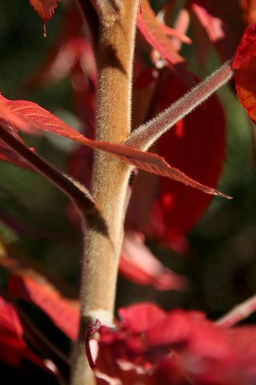
Flora
Pictures courtesy of Nartreb

|
|
|---|
External Links
Official DCR WebsiteFriends of the Fells - Lots of detailed information on history, background, nature, flora/fauna, trails, activities, etc.
Zoo New England - Located within the Reservation, a good place to take the kids
Fells1 - Mar 8, 2010 9:36 am - Voted 9/10
Spot Pond BoatingGreat website! Lot of information, but some of it is incomplete. It is true that, "Non-motorized boats are allowed on this large backup reservoir. Boat Launch area is located on Woodland Rd, next to the Stone Zoo." But, as a reservoir the state has to be very carefully not to introduce any of the many invasive plants and animals. The only boats allowed on Spot Pond are rentals from Spot Boat Boating www.outdoorrec.com/spot-pond.html. Spot Pond Boat is located about 1/2 mile south of the Stone Zoo between the Botume House Visitor Center a 4 Woodland Road and the Spot Pond Pump station (with a tall brick smoke stack).
Fells1 - Mar 8, 2010 9:50 am - Voted 9/10
Getting There by TUnlike the Blue Hills you don't have to have a car to get to the Middlesex Fells. Take an Orange Line train to the Oak Grove stop and get off on the Washington Street (east) side. Walk north (away from Boston) up Washington Street. Bear left at the "Y" intersection where Pleasant Street goes left. Just after the intersection turn right up Goodyear Avenue. Goodyear Avenue ends at the Gate-58 entrance to the Fells. There are over 50 miles of trails and fire roads in the 2500 acre Fells. It is easy to get a little lost. Trail maps are for sale at many locations in the Boston area. There's list at www.fells.org.
Castlereagh - Mar 8, 2010 9:30 pm - Hasn't voted
addedThanks! I added a link for the boat rentals and Orange Line info on the page.