
-
 1991 Hits
-
 75.81% Score
-
 6 Votes
|
|
Mountain/Rock |
|---|---|
|
|
38.55707°N / 110.72762°W |
|
|
Emery |
|
|
Hiking |
|
|
Spring, Fall, Winter |
|
|
5300 ft / 1615 m |
|
|
Overview
To the west of Goblin Valley, there are three "Wild Horse" mesas. Little Wild Horse Mesa can be accessed via a high clearance county road. Middle Wild Horse Mesa has a bunch of old mining tracks that one can hike (and see easily on aerial imagery). But the tough one is Big Wild Horse Mesa. This is the high band of cliffs immediately to the west of the state park that appears to be unassailable at first glance. However, there is one route to the summit that can be accessed off the park's bike trail network. It's actually very simple, but because I don't think many know about it, I thought I would make a post here.
Getting There
Just drive into Goblin Valley State Park and head to the mountain bike trail parking lot.
Note: There is an OHV track that reaches the southern part of Big Wild Horse Mesa and the "Rough Point" summit, but it is not possible to access this highest plateau from that direction.
Route

Finding the correct path is easy once you know what you're looking for. As you start to hike (or ride) the bike trails, look for this obvious weakness in the cliffs to the west/southwest. You'll see it right away. The bike trails follow the path of least resistance overall, though you'll eventually need to set off cross country. If you were riding, proceed on foot at this point to avoid stray tracks.

As you get close, the route becomes even more obvious. Just enter the main drainage and proceed up. Straight line distance from the parking lot to this spot is one mile, though traveling distance will be more depending on exactly which trails and routes you take.

As you proceed up the gully, the obstacles get bigger and bigger and finally you'll hit a dryfall you won't be able to get past. At some point, you'll need to hop out onto the slope at the right and aim for the rock circled in this photo. Exactly where you do this is up to you, as there are a couple options - including one just past the rock. Once you bypass the two biggest dryfalls, just re-enter the gully and scramble to the top. The total vertical climb is around 300 feet.
At no point did I encounter any serious exposure. The gully is very well protected, and the landscape where you exit to the right isn't terribly steep. However, due to loose dirt, there were a few places where someone could potentially fall far enough to get injured.
Once on top, you can wander north or south for miles, taking in views in every direction. Make sure to remember the way down! It's the only path without sheer cliffs. I built a cairn at the upper entrance to the gully, and took a GPS point: N 38.559838, W 110.725838
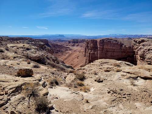
In addition to views of the Valleys of Goblins from very high up, you'll get scenery like this to the west that you can be sure almost nobody ever experiences.
Red Tape
2023 update: the entire hike, including most of the summit plateau, are now within the boundaries of Goblin Valley State Park. There is a $20-25 entry fee (depending on season) that is good for two days. If hiking the first mile, make sure to give right away to mountain bikers, as you'll be on their trails. Make extra sure to have pets leashed up for this same reason.
When to Climb
Any time is fine, though summer will be brutally hot. Winter temperatures can be perfect, though this not a route to try if conditions are icy.
Camping
Goblin Valley's campground has water and showers (no electricity) for $35 per night. There is also plenty of dispersed camping all over the area.
External Links
Add External Links text here.