
-
 10873 Hits
-
 82.48% Score
-
 15 Votes
|
|
Mountain/Rock |
|---|---|
|
|
45.71701°N / 122.0016°W |
|
|
Skamania |
|
|
Hiking, Scrambling |
|
|
Summer, Fall |
|
|
3763 ft / 1147 m |
|
|
Overview
Tired of the crowds on the popular gorge trails? Bored with the wide, well-maintained well-graded trails to the most popular mountains and viewpoints? – Well, Birkenfeld Mountain is for YOU!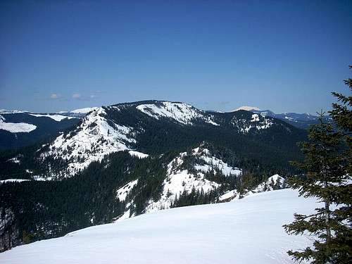
The PCT skirts the east side of South Birkenfeld (AKA Birkenfeld Ridge) and old logging roads skirt the edges of the mountain but there are no currently maintained trails on the main peak or it’s sister to the south and as such, you likely will have this mountain all to yourself. Combining the above with the difficulty getting close by road (4WD helpful but not absolutely necessary but higher than normal clearance may be needed) or the considerable distance and elevation gain involved in getting to the peak from the Columbia River level trailheads make this a sure bet for solitude.
Information is sparse but it appears the mountain was named for early timber pioneer Wilhelm Birkenfeld, an owner of the Carson Lumber Mill in the early 1900's. (As a side note, the huge 100 year old steam engine that powered his mill and, among many other things, cut the planks for many of the aircraft carriers of WWII is on display at the Skamania County Historical Museum in Stevenson, WA.) The mountain was in the process of being logged in September of 1902 when the great Yacolt Burn swept over it, burning most of the forest covering the peak. Logging continued farther south until another fire in September of 1929 finished off the rest of the marketable timber and ended forever the era of steam powered logging in the area and only salvage logging continued for a few years afterwards.
Relics of that bygone era still litter the flanks of the peak and provide entertainment and mystery for off-trail hikers. For example, for many years a story has persisted that an old steam locomotive is lost in the woods somewhere in the area. Such a find would be interesting indeed and here are a few photos of what this hiker thinks may be the source of the rumor:
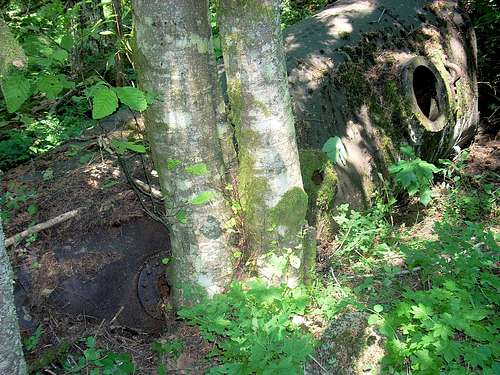
Possible source of the lost locomotive story located on the slopes of the peak.
And here is another treasure located near the above:
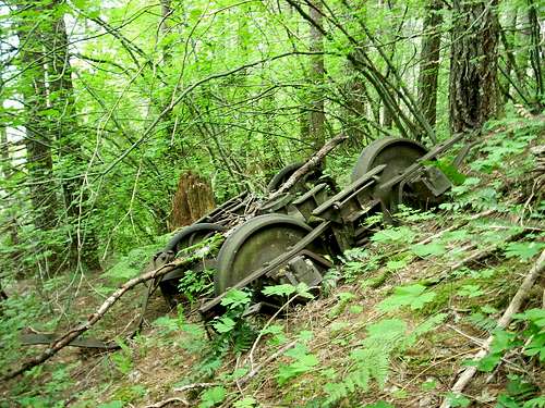
A rare find considering this is a 25% slope!
Getting There
There are several ways to get to the summit of the main peak:The Three Corner Rock approach via the PCT from the NW: Follow the directions to get to TCR (On the Three Corner Rock page) and then go SE on the PCT toward Birkenfeld. See the map once you get close.
The Table Mountain/PCT approach from the south:
This is the most difficult and longest approach but gives you the option of adding Table Mountain to your trek for an epic day of enjoyment on the trails. Take any of the several trailheads accessing Table Mountain from the south. The two closest are near Greenleaf Slough. (See map on the Table Mountain page.) Once at the main junction with the PCT and the Table Mountain Trail, either continue on the PCT to the pass where the powerline crosses north of Table Mountain, or climb up and over Table Mountain and take the bootpath trail north from the summit to the same powerline crossing a mile north of the summit. From there, hike up the ATV trail heading north to South Birkenfeld as described in “The 4WD approach from the SE.”
Accessing the closest Table Mountain trailhead would make this a minimum of 4,000’ vertical and ~15.3 miles for the round trip. Crossing over the top of Table and returning via the PCT would keep the distance about the same but add at least 500’ vertical to the trip – twice that if the return went back over the top of Table.
The 4WD approach from the SE:
From Washington State Route 14, 1.5 miles east of the Bridge of the Gods, turn north about 100 feet east of MP 43. Turn left in 3/10 miles. (Don't turn on the Skamania Lodge entrance road but on SW Foster Creek Road, about 100 feet past the lodge driveway) After another 7/10 miles go left uphill onto Ryan Allen Road. In a short distance, turn left onto Red Bluff Road. Follow Red Bluff 7/10 miles and turn left at the junction with CG2020. Stay on this rough gravel road for the next ~6.3 miles until you get to the 5-way junction (see map.) This is a very rough road that will require 4WD in a couple of spots in the best of conditions. (In wet conditions, even 4WD is difficult.)
Update, Nov. 1, 2017: Extensive logging operations are ongoing to the east and north of the road so beware of possible log trucks as you drive in. The good news is that the road has been much improved and a regular 2WD car can handle the route. However, many new logging spur roads complicate route finding. If you take a wrong turn, you will find out soon enough as you will run into a dead end or a gate and have to backtrack. Have fun!
At the 5-way junction, take a hard right and go another 5/10 mile and turn right at the junction with CG 2028 (As of 10/08 there is a sign that says 044 and the CG 2028 sign is gone). The trailhead is on the left in 1/10 mile. The trail may be marked with a ribbon – (stick to the ridgeline and you will see the faint track of a long abandoned trail.) There are more ribbons along the route but they are intermittent – stay close to the ridgeline and use your best tracking skills! Use the attached map. (Note: some maps give conflicting numbers to the roads radiating out from the five-way junction - the map on this page is consistant with the signs in place as of 10/08/2008.)
To access South Birkenfeld, continue on the main logging road past the junction with CG2028(044)for another 1.5 miles and park at the pass where the power line crosses. Take the ATV trail north up the hill for 1/10 mile, cross the PCT, and follow the bootpath up and over South Birkenfeld. After summiting South Birkenfeld and reaching the saddle, continue north, follow the PCT for a short distance (~750 feet) and find the bootpath on the east side of the ridge. Follow this hard-to-follow old trail to the summit of the main peak while it weaves in and out of the forest and the brush. You can make a loop out of this by using the logging road to return to your vehicle making this hike ~3.9 miles and ~1,200’ vertical.
Persistent lingering snow will make the CG 2020 road access problematical some years, but usually it's doable by late March or April - most years. (The all-time record for snow occurred in 2008 and the road was still blocked just short of the five-way junction as of July 1 - but that's rare, indeed.)