
|
|
Area/Range |
|---|---|
|
|
18.09234°N / 76.6008°W |
|
|
Hiking |
|
|
Spring, Winter |
|
|
7402 ft / 2256 m |
|
|
Overview: The Blues and the Crows
The Nature Conservancy (TNC) is currently working in the Blue and John Crow Mountain ranges in Jamaica and they have provided the following information which wholly describes the differing areas.
Although the two mountain ranges - the Blue and the John Crow - are geographically side by side, their geology, soil and vegetation are vastly different. The Río Grande Valley separates the two ranges.
The Blue Mountains rise sharply within nine miles (15 kilometers) of the coast and are characterized by steep-sided valleys and deeply gorged rivers. The Grand Ridge, which forms the spine of the ridge, extends 10 miles (16 kilometers) and includes Blue Mountain Peak, the highest point in Jamaica (7,402 feet; 2,256 meters).
In contrast, the John Crow Mountains rise gently from the east to a maximum height of 3,740 feet (1,140 meters), and end abruptly in a steep escarpment to the west.
From Frommers:
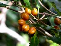
The mountainsides are covered with coffee fields, producing a blended brew that's among the leading exports of Jamaica. But for the nature enthusiast, the mountains reveal an astonishingly complex series of ecosystems that change radically as you climb from sea level to fog-shrouded peaks.
The Blue Mountains, Jamaica's highest peaks, form a virtual botanical Garden of Eden. Steep and exhausting, and invariably hot and muggy, the trails and hikes are not as hazardous -- or frightening -- as, say, the Alpine peaks of Switzerland and Austria. The foothills of the Blue Mountains begin on the outskirts of Kingston.
To the east of the Blue Mountains, moving toward the sea, are the John Crow Mountains, another vast area of scenic beauty, although the trails here are more overgrown than the more trodden paths of the Blue Mountains. The most dedicated hikers can go, in 3 days, from the Grand Ridge of the Blue Mountains to Port Antonio on the coast. But they need a machete to hack their way and blaze a trail.
Check out my Blue Mountain Peak page HERE
Getting There
From Frommers:If you're not a hiker, the easiest way to tour the Blue Mountains is by car, although you'll miss the most remote or difficult-to-reach beauty spots. You can, however, get quite a dramatic preview via the road. The main route into the Blue Mountains is the B1, which begins on the western outskirts of Kingston. Follow signposts to the hamlet of The Cooperage, the gateway to the mountains.
Though improved, this narrow road is still difficult; landslides do occur during the rainy season. Many drivers prefer a four-wheel-drive vehicle. Also watch for oncoming trucks -- the macho drivers won't give an inch. And remember that the last gas station (called "petrol" here) is on the outskirts of Papine, in northeast Kingston. You'll need to fill up there. Public transport in the mountains is hopelessly unreliable.
The following information is taken from my Blue Mountain Peak page - the "Getting There" section:

Hiking the trails to Blue Mountain Peak can be done from either the south side of the Island from Kingston or the north side from Port Antonio although entering the mountains from Kingston is much more common. Unless you’re staying at a hotel in Port Antonio that has information about hiking the mountain, good luck finding many (or any) locals who have made the journey or know how to get you to where you need to be. I started my Blue Mountain Peak adventure from Kingston and even still had trouble finding a cab driver who knew how to drive to Mavis Bank where many hikers begin their trek.
To get to the mountains from Kingston, Hire a JUTA taxi driver who knows his way around the mountains. You’ll head north out of the city on Old Hope Road which is paved and relatively well kept until you get to the one-way bridge in the small foothills village of Gordon Town. From here you’ll make a right and head over the bridge – this is when you’ll notice the neglect of the roads. Potholes, dips that lead to cliff ledges and old, rusted car wrecks along the side of the road are sure get your heart going as this is where the adventure truly begins – and I forgot to mention that you’ll be traveling along this one way mountain road at about 80 kilometers an hour, way too fast if you ask me. Expect the rest of the ride in the foothills to take another 30 minutes or so until you come to the town of Mavis Bank which sits in the Yallahs River Valley in the upper foothills.
From Mavis Bank, where you typically meet up with your guide, you’ll make the hour long, five mile drive up the narrow, steep, winding road through the upper foothills to the trailhead at Penlyne Castle near Abbey Green Coffee Plantation which sits at 4500 feet. “Abbey Green is a completely different world, where wind whistles through eucalyptus trees and mists billow over the mountainside only to evaporate in the sun.”* If you’re trekking the mountain alone and haven’t made plans to hire a guide and jeep be sure to ONLY attempt the road from Mavis Bank in a vehicle with four wheel drive – you won’t make it far without a Jeep or Land Rover.
“On the way up, you'll turn left through Hagley Gap – a one-street village where you can buy provisions and get a hot meal – after which you'll traverse one of the least road-like roads in Jamaica, with huge gullies carved through the clay by coursing water and a constant scree of small boulders in your path.”* Once at the trailhead, which is the beginning of a service road for trucks and jeeps in the upper reaches of the coffee plantation you’ll feel completely alone unless other hikers are coming to the area at the same time.
*Quotes from Rough Guides*
Blue and John Crow Mountains National Park

Similarly, UNESCO, the United Nations Educational Scientific and Cultural Organization and the Jamaica Conservation and Development Trust provide information about the park:
The Blue and John Crow Mountains National Park (BJCMNP) is located in the eastern end of the island of Jamaica. It extends over a planimetric area of 495.2 km2 and represents 4.5% of Jamaica's land surface.
When topography is taken into consideration, the area is 78,212 hectares (193,292 acres). The mountains of the Park dominate the skyline of eastern Jamaica, and incorporate much of the hinterland of the parishes of Portland, St. Thomas, St. Andrew and a small section of south-east St. Mary. The steep mountain slopes form the upper sections of ten (10) of the island's twenty-six (26) watershed management units. The highest point in the island - Blue Mountain Peak (2,256 meters) is located in the southern region of the Park. The BJCMNP is actually composed of three mountain ranges - the Port Royal, Blue, and John Crow Mountains, divided by the Buff Bay and Rio Grande Valleys on the north side of the ranges.
The BJCMNP contains the largest contiguous tract of closed broad-leaf forest in Jamaica, and its upper and lower montane rain-forests are recognized globally for their high biological diversity and threatened status. The core, Preservation Zone of the Park consists of closed primary forest with broadleaf trees and makes up 53.2% of the Park. 40% consists of modified forest, timber plantations and ruinate or degraded woodlands and these areas along with about 4% agricultural and residential make up the Preservation Zone Buffer and Recovery Zones. Outside these areas, a 1 km-wide band is considered the Buffer Zone, in which Park management works with the rural communities to promote environmentally sustainable livelihoods and sustained, appropriate management of the area's natural and cultural resources.
The Park is also essential for:
• absorbing carbon dioxide and producing oxygen - cleansing the air and reducing global warming
• Necessary for conserving the highly erodible soil of the area - preventing soil erosion and landslides
• Vital for providing water - the Park supplies over 40% of the population of Jamaica with domestic water, in addition to water for agricultural, industrial and commercial usage
• A component of the socio-cultural traditions of the Maroons and rural Jamaican communities. These traditions include food, craft, language, music and dance, are all highlighted at Misty Bliss - an annual festival at Holywell - the Park's main recreation area.
Plants and Animals of the Mountains
Animals:At least 150 resident and migratory bird species live in these mountains. Migratory species include the worm-eating warbler and the Swainson's warbler. The Jamaican blackbird, yellow-billed parrot, and ring-tailed pigeon are three of the 28 bird species found nowhere else on Earth.
These mountains also are prime habitat for tree frogs, giant swallowtail butterflies and the Jamaican hutia (a large rodent; also called the coney), the island's only land mammal. The hutia is similar in size to a groundhog.
Plants:
Trees such as mahogany, cedar, mahoe and broadleaf make up Jamaica's largest remaining intact, closed canopy rain forest.
(From UNESCO) The forests of the mountains are:
• The last of two known habitats of the Giant Swallowtail Butterfly (Papilio homerus) - the largest butterfly in the Western Hemisphere
• Important habitat for many Jamaican birds, including all the endemic species such as the endangered Jamaican Blackbird (Neospar nigerrimus) and winter habitat for many migratory birds
• A refuge for Jamaican wildlife including the Jamaican Boa (Epicrates subflavus) and the Jamaican Hutia (Geocapromys brownii)
• Home to numerous endemic orchids, bromeliads, fern and other plants (including many on the IUCN Red List)
Camping
M. Timothy O'Keefe writes:The Jamaican Forestry Department offers cabins and dormitories in the Blue Mountains, but permits must be paid for and picked up in advance at the Kingston office. You cannot simply show up at the site and pay. JATCHA can make the reservations and have the permits waiting for you. No linens, blankets or kitchen utensils are at any of the forest camps.
Camping and cabin reservations for all but Whitfield Hall can be made by calling the forestry department at 876/924-2667 or 876/924-2668.
Hollywell National Recreation Park offers tent camping and several cabins with fireplace, small kitchen and full bathroom. (This site is often called Holywell National Recreation Area.)
Clydesdale is an old coffee plantation/pine nursery at 3,700 feet with a bunk bed dormitory that can sleep 30 and more. Flush toilets, showers and a fire pit for cooking.
The walk from Clydesdale to the public Cinchona Botanical Gardens takes about an hour, where tent camping is available.
On the hike up Blue Mountain Peak, most people overnight at the privately owned Whitfield Hall Hostel, which may also permit you to tent camp; 876/927-0986.
About 1 to 1-1/2 hours beyond Whitfield Hall on the way to the peak is the Portland Gap forestry hut at 5,200 feet. The hut is rustic and you sleep on the floor. It also has running water, an outhouse and space for about 30 tents. Given a choice between Whitfield Hall (which does supply linens, etc.) and the forest hut, there is no choice unless you like the hermit life.
At Blue Mountain Peak itself is a rough, graffiti-covered forest hut often used by partying groups from Kingston on weekends. Water may not be readily available, and it gets quite cold at the peak from December through February. Tent camping is permitted.
Map of the Blue Mountains
 Map of the Blue Mountains